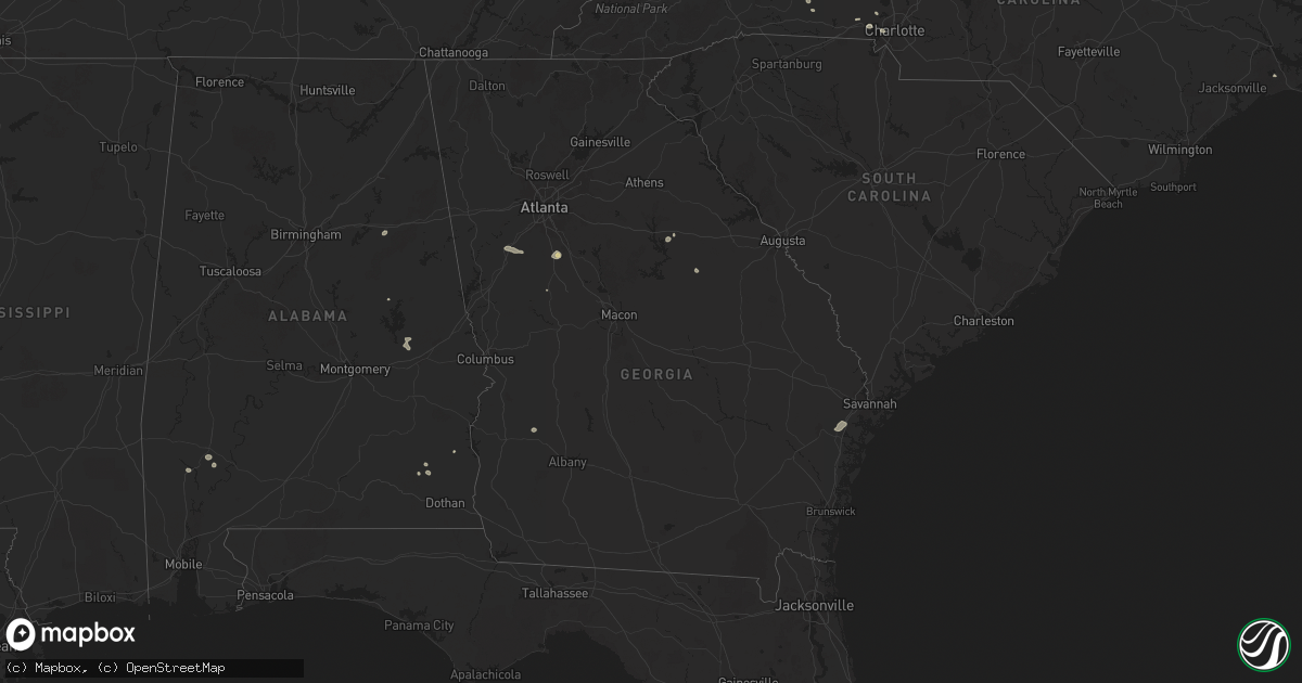
Hail Map in Georgia on August 1, 2025
Get this storm
August 1 map
$229
one time, instant access
Download today. No call, no setup
Keep the $229
Bought the map and want the full workflow? Apply the entire $229 to a subscription within 7 days. None of it is wasted.
Every map, not just this one
This buys you this map. Subscription and you get every map we run, in the markets you choose from a few cities to whole states to nationwide. Plus real-time alerts the moment a storm fires.
Contact data
Name, contact info, occupancy, even credit band for addresses in the footprint. You go from where it hit to who to call.
Become the source they trust
Unlimited branding weather history reports on demand. You already have the documented answer ready for the property owner, and you are the one who showed up with it.
Property data and RoofTrace estimates
Pull up any address you have got, its value and the exact code rules for that jurisdiction, straight from One Click Code. Then RoofTrace estimates the squares, pitch, and roof value, priced the way you price.
Storm reports in Georgia
Georgia
| Date | Description |
|---|---|
| 08/01/20256:59 PM CDT | A tree reported down on one lane of old poor robin road near the intersection with newington highway. |
| 08/01/20253:54 PM CDT | A tree resulted in a power outage along terrace blvd via the georgia power outage map. |
| 08/01/20253:53 PM CDT | A tree and power line were down along sustella ave. |
| 08/01/20253:40 PM CDT | Social media picture of the top of a large oak tree snapped off. The damage was in the backyard of a home along harris trail road. |
| 08/01/20253:39 PM CDT | Broadcast media shared viewer photos from the piercefield neighborhood of richmond hill... Ga. Photos showed numerous large tree branches down. One flag pole was blown |
| 08/01/20253:30 PM CDT | One tree down along highway 17 near the city limits of richmond hill... Ga. |
| 07/31/202511:02 PM CDT | The tybee south weatherflow observed a 52 kt wind gust. |
All States Impacted by Hail Map on August 1, 2025
Cities Impacted by Hail Map on August 1, 2025
- Dodson, MT
- Harlem, MT
- Hays, MT
- Lake City, CO
- Dawson, GA
- Parrott, GA
- Henrietta, TX
- Ellenboro, NC
- Casar, NC
- Munford, AL
- Lawndale, NC
- Talladega, AL
- Tobaccoville, NC
- Pfafftown, NC
- Winston Salem, NC
- Rural Hall, NC
- Patrick, SC
- West, MS
- Tow, TX
- Burnet, TX
- Yadkinville, NC
- Lewisville, NC
- Maben, MS
- Lampasas, TX
- Shelby, NC
- Mathiston, MS
- Harmony, NC
- Mocksville, NC
- Eros, LA
- Newnan, GA
- La Jara, CO
- Abbeville, AL
- Loring, MT
- Sharpsburg, GA
- Camp Hill, AL
- Tallassee, AL
- Boncarbo, CO
- Hobson, MT
- Killeen, TX
- Corsicana, TX
- Sanford, CO
- Antonito, CO
- Maiden, NC
- Lincolnton, NC
- Notasulga, AL
- Statesville, NC
- Buffalo, SD
- Stanford, MT
- Capulin, CO
- Briggs, TX
- Kempner, TX
- Trinidad, CO
- Weston, CO
- Kerens, TX
- Troutman, NC
- Conway, SC
- Lubbock, TX
- Hampton, GA
- Griffin, GA
- Brownfield, TX
- Havelock, NC
- Reva, SD
- Mason, TX
- Locust Grove, GA
- Longs, SC
- Mooresville, NC
- Brady, TX
- Wheatland, WY
- Morganton, NC
- Dallas, NC
- Wetmore, CO
- Gastonia, NC
- McAdenville, NC
- Belmont, NC
- Cramerton, NC
- Lowell, NC
- Fleming, GA
- Richmond Hill, GA
- Midway, GA
- Penrose, CO
- Pueblo, CO
- Prairie City, SD
- Sherrills Ford, NC
- Salisbury, NC
- Linwood, NC
- Kellyton, AL
- Alexander City, AL
- Stanley, NC
- Cubero, NM
- Lexington, NC
- Elizabeth, CO
- Elbert, CO
- Franktown, CO
- Big Timber, MT
- Mount Holly, NC
- Groesbeck, TX
- Charlotte, NC
- Columbus, MT
- Lodge Grass, MT
- Bessemer City, NC
- Absarokee, MT
- Newell, SD
- Model, CO
- Moccasin, MT
- Seagraves, TX
- Walsenburg, CO
- Bennett, CO
- Junction, TX
- Zebulon, GA
- Fowler, CO
- Augusta, MT
- Greensboro, GA
- Cheyenne, WY
- Lamesa, TX
- Mud Butte, SD
- Fort Hood, TX
- Guernsey, WY
- Thornton, TX
- Fort Lupton, CO
- Casper, WY
- Eldorado, TX
- Ocate, NM
- Datil, NM
- Bison, SD
- Miami, NM
- Meadow, SD
- Guadalupita, NM
- Albin, WY
- Pine Bluffs, WY
- Burns, WY
- White Plains, GA
- Matheson, CO
- Immokalee, FL
- Clinton, SC
- Sparta, GA
- Belton, TX
- Temple, TX
- Whitmire, SC
- Limon, CO
- Magdalena, NM
- Skipperville, AL
- Ozark, AL
- Hudson, CO
- Orofino, ID
- Glenrock, WY
- Morrill, NE
- Crow Agency, MT
- Saint Xavier, MT
- Mitchell, GA
- Lemmon, SD
- Lodgepole, SD
- Hugo, CO
- Fe Warren Afb, WY
- Buffalo, MT
- Rocky Ford, CO
- Overton, TX
- Kilgore, TX
- Faith, SD
- Shawmut, MT
- Saluda, SC
- Bushnell, NE
- Somes Bar, CA
- Garryowen, MT
- Warthen, GA
- Pachuta, MS
- Harrison, NE
- Troup, TX
- Midwest, WY
- Rosebud, TX
- Wagon Mound, NM
- Reagan, TX
- Lott, TX
- Jacksonville, TX
- Fort Jones, CA
- Grand Saline, TX
- Valmora, NM
- Custer, MT
- Carpenter, WY
- Karval, CO
- Ramah, CO
- Haswell, CO
- Arlington, CO
- Kit Carson, CO
- Dupree, SD
- Moore, MT
- Union Center, SD
- Sand Coulee, MT
- Great Falls, MT
- Trementina, NM
- Saint George, SC
- Grover, CO
- Lewistown, MT
- Las Vegas, NM
- Klamath River, CA
- Hilger, MT
- Gillette, WY
- Mims, FL
- Harleyville, SC
- Henderson, TX
- Hereford, CO
- Eads, CO
- Deadwood, SD
- Rusk, TX
- Pickton, TX
- Lead, SD
- Murchison, TX
- White Owl, SD
- Howes, SD
- Hill City, SD
- Leroy, AL
- Happy Camp, CA
- Cross Plains, TX
- Brownsboro, TX
- McGregor, TX
- Huntington, TX
- Winnsboro, TX
- Saint Stephens, AL
- Bruneau, ID
- Quitman, TX
- Scroggins, TX
- Padroni, CO
- Sterling, CO
- Peetz, CO
- Iliff, CO
- Fleming, CO
- Crook, CO
- Birney, MT
- Pittsburg, TX
- Leesburg, TX
- Gilmer, TX
- Cherry Creek, SD
- Atwood, CO
- Sedgwick, CO
- Haxtun, CO
- Wild Horse, CO
- Grove Hill, AL
- La Junta, CO
- Jackson, AL
- Two Dot, MT
- Weston, WY
- Akron, CO
- Cheyenne Wells, CO
- Sheridan Lake, CO
- Las Animas, CO
- Otis, CO
- Cameron, TX
- Milesville, SD
- Sundance, WY
- Yuma, CO
- Ovid, CO
- Julesburg, CO
- Devils Tower, WY
- Dix, NE
- Potter, NE
- Burkett, TX
- Sidney, NE
- Kimball, NE
- Winnett, MT
- Como, TX
- Cleveland, TN
- Holyoke, CO
- Eckley, CO
- Paoli, CO
- Wray, CO
- Venango, NE
- Amherst, CO
- Colorado City, TX
- Hermleigh, TX
- Geyser, MT
- Vaughn, NM
- Sturgis, SD
- Champion, NE
- Zortman, MT
- Lloyd, MT
- Snyder, TX
- Kim, CO
- Powderly, TX
- Arthur City, TX
- Santa Rosa, NM
- Klondike, TX
- Ogallala, NE
- Beulah, WY
- Raynesford, MT
- Chinook, MT
- Spearfish, SD
- Alzada, MT
- Grand View, ID
- Cumby, TX
- Lemoyne, NE
- Blossom, TX
- Detroit, TX
- Hammond, MT
- Springfield, CO
- Keystone, NE
- Commerce, TX
- Whitewood, SD
- Big Sandy, MT
- Geraldine, MT
- Paris, TX
- Terrell, TX
- Stapleton, NE
- Hugo, OK
- Yeso, NM
- Kaufman, TX
- Wall, SD
- Paxton, NE
- Belle Fourche, SD
- Nemo, SD
- Lincoln, NM
- Hayes Center, NE
- Zavalla, TX
- Ekalaka, MT
- Sulphur Springs, TX
- Brashear, TX
- Palisade, NE
- Newcastle, WY
- Merkel, TX
- Philip, SD
- Culbertson, NE
- Hawley, TX
- Oneill, NE
- Chappell, NE
- North Platte, NE
- Brady, NE
- Loma, MT
- Fort Benton, MT
- Malta, MT
- Billings, MT
- Cuervo, NM


