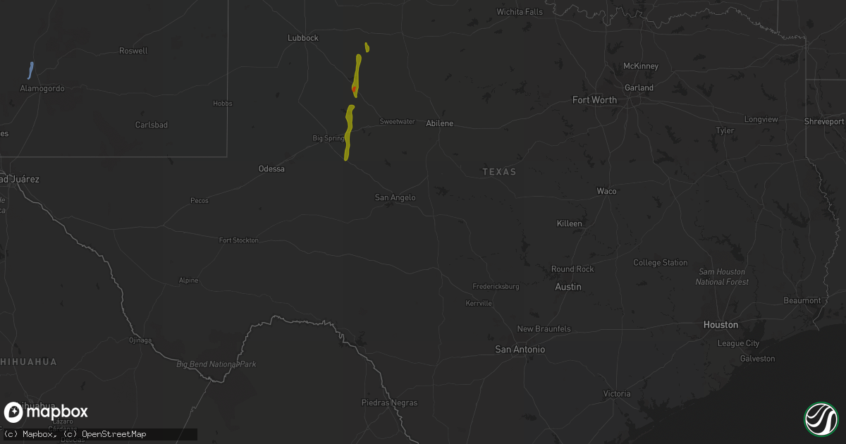
Hail Map in Texas on August 1, 2020
Get this storm
August 1 map
$229
one time, instant access
Download today. No call, no setup
Keep the $229
Bought the map and want the full workflow? Apply the entire $229 to a subscription within 7 days. None of it is wasted.
Every map, not just this one
This buys you this map. Subscription and you get every map we run, in the markets you choose from a few cities to whole states to nationwide. Plus real-time alerts the moment a storm fires.
Contact data
Name, contact info, occupancy, even credit band for addresses in the footprint. You go from where it hit to who to call.
Become the source they trust
Unlimited branding weather history reports on demand. You already have the documented answer ready for the property owner, and you are the one who showed up with it.
Property data and RoofTrace estimates
Pull up any address you have got, its value and the exact code rules for that jurisdiction, straight from One Click Code. Then RoofTrace estimates the squares, pitch, and roof value, priced the way you price.
Storm reports in Texas
Texas
| Date | Description |
|---|---|
| 08/01/20206:10 PM CDT | A local report indicates 60 MPH wind near 2 ENE COAHOMA |
| 08/01/20204:42 PM CDT | Video of a landspout near petronila via social media. Time estimated off of radar. |
| 08/01/20204:13 PM CDT | Measured by the west texas mesonet |
| 08/01/20203:11 AM CDT | At 810 PM CDT, severe thunderstorms were located along a line extending from Lasara Elementary School to Laguna Seca, moving southeast at 15 to 20 mph. HAZARD...60 mph wind gusts and nickel size hail. SOURCE...Radar indicated. IMPACT...Expect damage to roofs, siding, and trees. Locations impacted include... Harlingen, Raymondville, La Feria, Elsa, Edcouch, Santa Rosa, Lyford, La Villa, Palm Valley and Los Indios. |
| 08/01/202012:25 AM CDT | At 525 PM CDT, a severe thunderstorm was located near J B Thomas Reservoir, or 17 miles northwest of Colorado City, moving south at 20 mph. HAZARD...60 mph wind gusts and quarter size hail. SOURCE...Radar indicated. IMPACT...Hail damage to vehicles is expected. Expect wind damage to roofs, siding, and trees. Locations impacted include... Colorado City, Colorado City Airport, Lake Colorado City, Lake Colorado City State Park, Champion Creek Reservoir, Westbrook, Vincent and Cuthbert.This includes Interstate 20 between mile markers 191 and 216. |
| 07/31/202011:40 PM CDT | At 440 PM CDT, a severe thunderstorm was located near Fluvanna, or 9 miles south of Lake Alan Henry, moving south at 20 mph. HAZARD...60 mph wind gusts and quarter size hail. SOURCE...Radar indicated. IMPACT...Hail damage to vehicles is expected. Expect wind damage to roofs, siding, and trees. Locations impacted include... Snyder, Fluvanna, J B Thomas Reservoir, Randalls Corner, Winston Field, Ira and Knapp. |
| 07/31/202011:20 PM CDT | At 420 PM CDT, a severe thunderstorm was located over Spur, moving south at 25 mph. HAZARD...60 mph wind gusts and quarter size hail. SOURCE...Radar indicated. IMPACT...Hail damage to vehicles is expected. Expect wind damage to roofs, siding, and trees. Locations impacted include... Spur, Jayton and Girard. |
| 07/31/202010:41 PM CDT | At 340 PM CDT, a severe thunderstorm was located 12 miles southeast of Kalgary, or 15 miles south of White River Lake, moving south at 25 mph. HAZARD...60 mph wind gusts and quarter size hail. SOURCE...Radar indicated. IMPACT...Hail damage to vehicles is expected. Expect wind damage to roofs, siding, and trees. Locations impacted include... Lake Alan Henry and Justiceburg. |
| 07/31/20208:30 PM CDT | A large metal awning from a local convenient gas station severly damaged and partially blown off. Estimated winds of at least 60 to 70 mph. |
| 07/31/20208:30 PM CDT | A large metal awning from a local convenient gas station severly damaged and partially blown off. Estimated winds of at least 60 to 70 mph at the intersection if bass b |
All States Impacted by Hail Map on August 1, 2020
Cities Impacted by Hail Map on August 1, 2020
- Clines Corners, NM
- Ribera, NM
- Moriarty, NM
- Woodward, OK
- Tularosa, NM
- Chambersburg, PA
- Waynesboro, PA
- Greencastle, PA
- Quincy, PA
- Hoxie, KS
- Healy, KS
- Garden City, KS
- Park, KS
- Grainfield, KS
- Dighton, KS
- Gove, KS
- Cimarron, KS
- Whipple, OH
- Reno, OH
- Marietta, OH
- Williamstown, WV
- Kaycee, WY
- Casper, WY
- Hyattville, WY
- Manderson, WY
- Tie Siding, WY
- Livermore, CO
- Buford, WY
- Red Feather Lakes, CO
- Bellvue, CO
- Snyder, TX
- Fluvanna, TX
- Justiceburg, TX
- Spur, TX
- Westbrook, TX
- Sterling City, TX
- Colorado City, TX
- Ira, TX
- Big Spring, TX
- Coahoma, TX
- La Feria, TX
- Edcouch, TX
- Harlingen, TX
- La Villa, TX
- Santa Rosa, TX
- Show Low, AZ
- Forest Lakes, AZ
- Heber, AZ
- Sedona, AZ
- Mayer, AZ
- Camp Verde, AZ
- Cochise, AZ
- Patagonia, AZ
- Ten Sleep, WY
- Big Pool, MD
- Hedgesville, WV
- Clear Spring, MD
- Chase, KS
- Bushton, KS
- Ellinwood, KS
- Mercedes, TX
- Magdalena, NM
- Willcox, AZ
- Chester, OK
- Rexford, KS
- Colby, KS
- Hereford, AZ
- Oakley, KS
- Custer, SD
- Benson, AZ
- Sylvia, KS
- Claflin, KS
- Kersey, CO
- Payson, AZ
- Columbia, NC
- Pima, AZ
- Clifton, AZ
- Sistersville, WV
- Pine, AZ
- Laramie, WY
- Plevna, KS
- Elgin, AZ
- Sierra Vista, AZ
- Mercersburg, PA
- Spencer, WV
- Spivey, KS
- Edinburg, TX
- Peridot, AZ
- Harman, WV
- Holly Springs, NC
- Fuquay Varina, NC
- Sanford, NC
- New Hill, NC
- Berkeley Springs, WV
- Morenci, AZ
- Concho, AZ
- Rio Rico, AZ
- Waynoka, OK
- Fort Supply, OK
- Rodeo, NM
- Smithfield, NC
- Princeton, NC
- Safford, AZ
- Rio Grande City, TX
- Saint David, AZ
- Corpus Christi, TX
- Emerson, IA
- Wendell, NC
- Como, NC
- Randolph, VA
- Clatonia, NE
- Ingalls, KS
- Springerville, AZ
- Elfrida, AZ
- Raymondville, TX
- Elsa, TX


