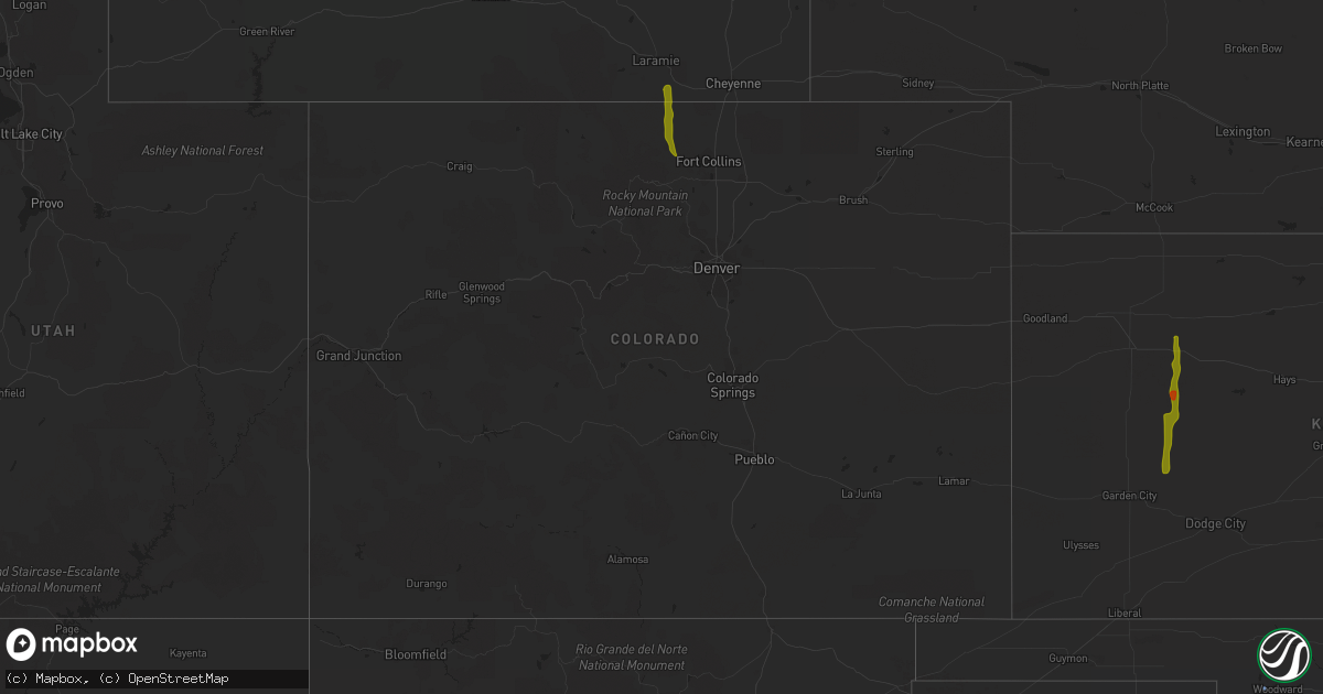
Hail Map in Colorado on August 1, 2020
Get this storm
August 1 map
$229
one time, instant access
Download today. No call, no setup
Keep the $229
Bought the map and want the full workflow? Apply the entire $229 to a subscription within 7 days. None of it is wasted.
Every map, not just this one
This buys you this map. Subscription and you get every map we run, in the markets you choose from a few cities to whole states to nationwide. Plus real-time alerts the moment a storm fires.
Contact data
Name, contact info, occupancy, even credit band for addresses in the footprint. You go from where it hit to who to call.
Become the source they trust
Unlimited branding weather history reports on demand. You already have the documented answer ready for the property owner, and you are the one who showed up with it.
Property data and RoofTrace estimates
Pull up any address you have got, its value and the exact code rules for that jurisdiction, straight from One Click Code. Then RoofTrace estimates the squares, pitch, and roof value, priced the way you price.
Storm reports in Colorado
Colorado
| Date | Description |
|---|---|
| 08/01/20203:31 PM CDT | Asos station kdro durango la plata cnty airport. |
| 08/01/20201:45 AM CDT | At 645 PM MDT, a severe thunderstorm was located 5 miles east of Red Feather Lakes, or 26 miles northwest of Fort Collins, moving south at 25 mph. HAZARD...60 mph wind gusts and quarter size hail. SOURCE...Radar indicated. IMPACT...Expect damage to roofs, siding, and trees. Hail damage to vehicles is expected. Locations impacted include... Buckhorn Mountain, Mishawaka and Red Feather Lakes. |
| 07/31/20207:58 PM CDT | A local report indicates 1.00 inch wind near 5 NW MISHOWAKA |
| 07/31/20207:58 PM CDT | Hail was 1.5 to 1.75 inches in diameter. Delayed report. |
| 07/31/20207:44 PM CDT | Delayed report. |
| 07/31/20207:41 PM CDT | Delayed report. |
All States Impacted by Hail Map on August 1, 2020
Cities Impacted by Hail Map on August 1, 2020
- Clines Corners, NM
- Ribera, NM
- Moriarty, NM
- Woodward, OK
- Tularosa, NM
- Chambersburg, PA
- Waynesboro, PA
- Greencastle, PA
- Quincy, PA
- Hoxie, KS
- Healy, KS
- Garden City, KS
- Park, KS
- Grainfield, KS
- Dighton, KS
- Gove, KS
- Cimarron, KS
- Whipple, OH
- Reno, OH
- Marietta, OH
- Williamstown, WV
- Kaycee, WY
- Casper, WY
- Hyattville, WY
- Manderson, WY
- Tie Siding, WY
- Livermore, CO
- Buford, WY
- Red Feather Lakes, CO
- Bellvue, CO
- Snyder, TX
- Fluvanna, TX
- Justiceburg, TX
- Spur, TX
- Westbrook, TX
- Sterling City, TX
- Colorado City, TX
- Ira, TX
- Big Spring, TX
- Coahoma, TX
- La Feria, TX
- Edcouch, TX
- Harlingen, TX
- La Villa, TX
- Santa Rosa, TX
- Show Low, AZ
- Forest Lakes, AZ
- Heber, AZ
- Sedona, AZ
- Mayer, AZ
- Camp Verde, AZ
- Cochise, AZ
- Patagonia, AZ
- Ten Sleep, WY
- Big Pool, MD
- Hedgesville, WV
- Clear Spring, MD
- Chase, KS
- Bushton, KS
- Ellinwood, KS
- Mercedes, TX
- Magdalena, NM
- Willcox, AZ
- Chester, OK
- Rexford, KS
- Colby, KS
- Hereford, AZ
- Oakley, KS
- Custer, SD
- Benson, AZ
- Sylvia, KS
- Claflin, KS
- Kersey, CO
- Payson, AZ
- Columbia, NC
- Pima, AZ
- Clifton, AZ
- Sistersville, WV
- Pine, AZ
- Laramie, WY
- Plevna, KS
- Elgin, AZ
- Sierra Vista, AZ
- Mercersburg, PA
- Spencer, WV
- Spivey, KS
- Edinburg, TX
- Peridot, AZ
- Harman, WV
- Holly Springs, NC
- Fuquay Varina, NC
- Sanford, NC
- New Hill, NC
- Berkeley Springs, WV
- Morenci, AZ
- Concho, AZ
- Rio Rico, AZ
- Waynoka, OK
- Fort Supply, OK
- Rodeo, NM
- Smithfield, NC
- Princeton, NC
- Safford, AZ
- Rio Grande City, TX
- Saint David, AZ
- Corpus Christi, TX
- Emerson, IA
- Wendell, NC
- Como, NC
- Randolph, VA
- Clatonia, NE
- Ingalls, KS
- Springerville, AZ
- Elfrida, AZ
- Raymondville, TX
- Elsa, TX


