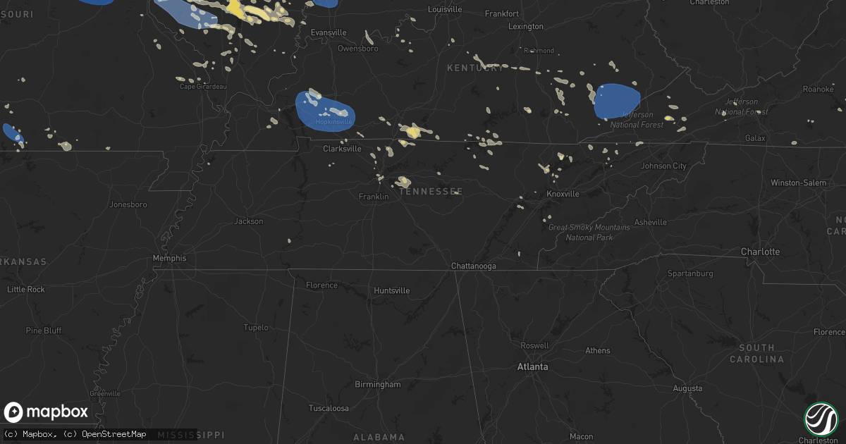
Hail Map in Tennessee on July 29, 2023
Get this storm
July 29 map
$229
one time, instant access
Download today. No call, no setup
Keep the $229
Bought the map and want the full workflow? Apply the entire $229 to a subscription within 7 days. None of it is wasted.
Every map, not just this one
This buys you this map. Subscription and you get every map we run, in the markets you choose from a few cities to whole states to nationwide. Plus real-time alerts the moment a storm fires.
Contact data
Name, contact info, occupancy, even credit band for addresses in the footprint. You go from where it hit to who to call.
Become the source they trust
Unlimited branding weather history reports on demand. You already have the documented answer ready for the property owner, and you are the one who showed up with it.
Property data and RoofTrace estimates
Pull up any address you have got, its value and the exact code rules for that jurisdiction, straight from One Click Code. Then RoofTrace estimates the squares, pitch, and roof value, priced the way you price.
Storm reports in Tennessee
Tennessee
| Date | Description |
|---|---|
| 07/29/20236:25 PM CDT | Multiple tree and power line reports across the county. Tree partially blocking roadway near harmony rd and tillery rd. Time estimated from radar. |
| 07/29/20236:15 PM CDT | Multiple reports of trees down across the county. Report of tree down blocking the road near turkey cove lane and parkside drive. |
| 07/29/20235:50 PM CDT | Dispatch reported multiple trees and powerlines down across the county... And trees and lines across some roadways. Time estimated from radar. |
| 07/29/20235:45 PM CDT | Dispatch reported multiple trees down in the jacksboro area. Time estimated from radar. |
| 07/29/20235:31 PM CDT | Twitter report of a tree down off cut off road in walterhill. Time estimated by radar. |
| 07/29/20235:20 PM CDT | Dispatch reported multiple trees and a few powerlines down across the county. Time estimated from radar. |
| 07/29/20235:18 PM CDT | Twitter pictures of tree/limbs down near the nashville zoo. Time estimated via radar. |
| 07/29/20235:00 PM CDT | Several trees down near south fentress park with highway 127 blocked and closed. Roof damage to clarkrange baptist church. |
| 07/29/20234:57 PM CDT | Several trees down throughout the county with multiple trees down in the edgar evans state park / center hill dam area. Minor metal roof damage to the marina as well. T |
| 07/29/20234:54 PM CDT | Report of of numerous trees and limbs down. Time estimated via radar. |
| 07/29/20234:51 PM CDT | A few trees were uprooted with 3 to 4 damaged power poles along saundersville road... Resulting in power outages. Time estimated by radar. |
| 07/29/20234:50 PM CDT | Corrects previous tstm wnd dmg report from 3 ne green hill. A small but intense microburst struck far north mount juliet. Dozens of trees were snapped and uprooted in a |
| 07/29/20234:45 PM CDT | Dispatch reported several trees and powerlines down county wide. Time estimated from radar. |
| 07/29/20234:40 PM CDT | Dispatch reported numerous trees and powerlines down across the county. Time estimated from radar. |
| 07/29/20234:20 PM CDT | Dispatch reported numerous trees down across the county. Time estimated from radar. |
| 07/29/20234:15 PM CDT | Dispatch reported numerous trees and lines down across the county. Time estimated from radar. |
| 07/29/20234:15 PM CDT | Report of multiple stoplights/lines down in kingsport near wilcox dr and east center street. Time estimated from radar. |
| 07/29/20233:45 PM CDT | Report of tree down blocking road near ellistown rd and shipe rd. Time estimated from radar. |
| 07/29/20233:30 PM CDT | Tspotter report of a downed tree at a residence in the new deal area. Pictures shared also show that the tree destroyed a fence. Time estimated based on radar. |
| 07/29/20233:28 PM CDT | Facebook report of flagpole snapped and several tree tops blown off in the oak grove area. |
| 07/29/20233:20 PM CDT | Dispatch reported tree down and some power outages. Time estimated from radar. |
| 07/29/20233:20 PM CDT | Multiple trees down across the county. Time estimated from radar. |
| 07/29/20232:40 PM CDT | Dispatch reported multiple trees down across the county. Time estimated from radar. |
| 07/29/20232:15 PM CDT | Dispatch reported multiple trees and powerlines down in kingston and harriman. Time estimated from radar. |
| 07/28/202311:10 PM CDT | Tspotter photos of roof blown off barn on old smithville highway north. |
All States Impacted by Hail Map on July 29, 2023
Cities Impacted by Hail Map on July 29, 2023
- Waterloo, IA
- Winthrop, IA
- Independence, IA
- Jesup, IA
- Dunkerton, IA
- Rowley, IA
- Fairbank, IA
- Brandon, IA
- Mount Auburn, IA
- Walker, IA
- Vinton, IA
- La Porte City, IA
- Atkins, IA
- Cedar Rapids, IA
- Center Point, IA
- Shellsburg, IA
- Quasqueton, IA
- Fairfax, IA
- Palo, IA
- Urbana, IA
- Durango, IA
- Bernard, IA
- Hopkinton, IA
- Coggon, IA
- Worthington, IA
- Central City, IA
- Robins, IA
- Delhi, IA
- Manchester, IA
- Marion, IA
- Ryan, IA
- Langworthy, IA
- Springville, IA
- Monticello, IA
- Alburnett, IA
- Farley, IA
- Dubuque, IA
- Earlville, IA
- Epworth, IA
- Peosta, IA
- Toddville, IA
- Dyersville, IA
- Anamosa, IA
- Cascade, IA
- Masonville, IA
- Prairieburg, IA
- Delaware, IA
- Hiawatha, IA
- Akron, CO
- Yuma, CO
- Joes, CO
- Cope, CO
- Tucson, AZ
- Cleveland, GA
- Clermont, GA
- Dahlonega, GA
- Murrayville, GA
- Dawsonville, GA
- Cartersville, GA
- Sutton, NE
- McCool Junction, NE
- York, NE
- Henderson, NE
- Grafton, NE
- Guide Rock, NE
- Edgar, NE
- Nelson, NE
- Superior, NE
- Bradshaw, NE
- Clay Center, NE
- Saronville, NE
- Oak, NE
- Geneva, NE
- Ong, NE
- Fairmont, NE
- Stromsburg, NE
- Benedict, NE
- Waco, NE
- Davenport, NE
- Shickley, NE
- Deshler, NE
- Ruskin, NE
- Hardy, NE
- Ohiowa, NE
- Strang, NE
- Carleton, NE
- Exeter, NE
- Bruning, NE
- Milligan, NE
- Tobias, NE
- Western, NE
- Gresham, NE
- Milford, NE
- Seward, NE
- Utica, NE
- Dorchester, NE
- Beaver Crossing, NE
- Crete, NE
- Friend, NE
- Cordova, NE
- Hebron, NE
- Belvidere, NE
- Daykin, NE
- Fairbury, NE
- Wilber, NE
- Alexandria, NE
- Swanton, NE
- Plymouth, NE
- De Witt, NE
- Jansen, NE
- Goehner, NE
- Pleasant Dale, NE
- Denton, NE
- Martell, NE
- Hallam, NE
- Cortland, NE
- Clatonia, NE
- Beatrice, NE
- Pickrell, NE
- Gilead, NE
- Steele City, NE
- Odell, NE
- Diller, NE
- Endicott, NE
- Blue Springs, NE
- Wymore, NE
- Sprague, NE
- Roca, NE
- Firth, NE
- Filley, NE
- Adams, NE
- Hickman, NE
- Bennet, NE
- Liberty, NE
- Virginia, NE
- Panama, NE
- Lincoln, NE
- Crab Orchard, NE
- Tecumseh, NE
- Douglas, NE
- Sterling, NE
- Palmyra, NE
- Burr, NE
- Unadilla, NE
- Syracuse, NE
- Cook, NE
- Elk Creek, NE
- Lewiston, NE
- Steinauer, NE
- Burchard, NE
- Talmage, NE
- Johnson, NE
- Auburn, NE
- Table Rock, NE
- Humboldt, NE
- Brock, NE
- Pawnee City, NE
- Brownville, NE
- Julian, NE
- Du Bois, NE
- Peru, NE
- Nebraska City, NE
- Dawson, NE
- Stella, NE
- Nemaha, NE
- Salem, NE
- Verdon, NE
- Shubert, NE
- Falls City, NE
- Rock Port, MO
- Fairfax, MO
- Craig, MO
- Rulo, NE
- Mound City, MO
- Forest City, MO
- Hiawatha, KS
- Sabetha, KS
- Morrill, KS
- White Cloud, KS
- Maitland, MO
- Oregon, MO
- Fillmore, MO
- Saint Joseph, MO
- Robinson, KS
- Wathena, KS
- Highland, KS
- Amazonia, MO
- Savannah, MO
- Troy, KS
- Cosby, MO
- Elwood, KS
- Barneston, NE
- Easton, MO
- Stewartsville, MO
- Agency, MO
- Clarksdale, MO
- Helena, MO
- Rosendale, MO
- Union Star, MO
- Maysville, MO
- Amity, MO
- Gower, MO
- Faucett, MO
- Denton, KS
- Bendena, KS
- Rushville, MO
- Dearborn, MO
- De Kalb, MO
- Atchison, KS
- Weston, MO
- Leavenworth, KS
- Platte City, MO
- Camden Point, MO
- Osborn, MO
- Edgerton, MO
- Winston, MO
- Smithville, MO
- Weatherby, MO
- Cameron, MO
- Trimble, MO
- Plattsburg, MO
- Lathrop, MO
- Turney, MO
- Excelsior Springs, MO
- Kearney, MO
- Holt, MO
- Liberty, MO
- Kingston, MO
- Gallatin, MO
- Hamilton, MO
- Altamont, MO
- Kidder, MO
- Polo, MO
- Lawson, MO
- Rayville, MO
- Cowgill, MO
- Richmond, MO
- Hardin, MO
- Braymer, MO
- Norborne, MO
- Breckenridge, MO
- Ludlow, MO
- Jamesport, MO
- Carrollton, MO
- Dawn, MO
- Bogard, MO
- Lock Springs, MO
- Chillicothe, MO
- Mooresville, MO
- Utica, MO
- Tina, MO
- Hale, MO
- Brunswick, MO
- Triplett, MO
- De Witt, MO
- Bosworth, MO
- Sumner, MO
- Slater, MO
- Dalton, MO
- Miami, MO
- Meadville, MO
- Wheeling, MO
- Mendon, MO
- Salisbury, MO
- Keytesville, MO
- Glasgow, MO
- Chula, MO
- Brookfield, MO
- Rothville, MO
- Laclede, MO
- Marceline, MO
- Linneus, MO
- New Cambria, MO
- Bucklin, MO
- Armstrong, MO
- Fayette, MO
- Clifton Hill, MO
- Callao, MO
- Huntsville, MO
- Bevier, MO
- Excello, MO
- Higbee, MO
- Rocheport, MO
- Columbia, MO
- Harrisburg, MO
- Macon, MO
- Sturgeon, MO
- Moberly, MO
- Cairo, MO
- Clark, MO
- Ashland, MO
- Hallsville, MO
- Centralia, MO
- Jacksonville, MO
- Madison, MO
- Holliday, MO
- Freedom, NH
- Madison, NH
- Brownfield, ME
- Porter, ME
- Ashley, IL
- Mount Vernon, IL
- Dix, IL
- Marissa, IL
- Saint Libory, IL
- Mascoutah, IL
- Ewing, IL
- Belle Rive, IL
- Ina, IL
- Carmi, IL
- Enfield, IL
- Nashville, IL
- Hoyleton, IL
- Waltonville, IL
- Woodlawn, IL
- Whigham, GA
- Cairo, GA
- McLeansboro, IL
- Pelham, GA
- Bonnie, IL
- Du Bois, IL
- Dahlgren, IL
- Springerton, IL
- New Harmony, IN
- Hartville, MO
- Bradfordsville, KY
- Gravel Switch, KY
- Macedonia, IL
- Opdyke, IL
- Carrier Mills, IL
- Marion, IL
- Lenzburg, IL
- Addieville, IL
- Keenes, IL
- Polk, NE
- Centralia, IL
- Scheller, IL
- Walnut Hill, IL
- Okawville, IL
- Oakdale, IL
- Whittington, IL
- Wayne City, IL
- Fulton, MO
- Thompson, MO
- Paris, MO
- Rush Hill, MO
- Mexico, MO
- Kingdom City, MO
- Auxvasse, MO
- Perry, MO
- Santa Fe, MO
- Laddonia, MO
- Benton City, MO
- Goffstown, NH
- Manchester, NH
- Farber, MO
- Vandalia, MO
- Martinsburg, MO
- Williamsburg, MO
- Montgomery City, MO
- Steedman, MO
- Wellsville, MO
- Portland, MO
- Rhineland, MO
- New Florence, MO
- Middletown, MO
- Warrenton, MO
- Truxton, MO
- Jonesburg, MO
- Bellflower, MO
- High Hill, MO
- Hermann, MO
- Hawk Point, MO
- Troy, MO
- Wright City, MO
- Silex, MO
- Moscow Mills, MO
- Truesdale, MO
- Foristell, MO
- Busy, KY
- Bulan, KY
- Hyden, KY
- Hazard, KY
- Bonnyman, KY
- Wooton, KY
- Krypton, KY
- Hindman, KY
- Combs, KY
- Carrie, KY
- Delphia, KY
- Smilax, KY
- Linefork, KY
- Viper, KY
- Partridge, KY
- Cornettsville, KY
- Slemp, KY
- Happy, KY
- Neon, KY
- Deane, KY
- Seco, KY
- Vicco, KY
- Sassafras, KY
- Whitesburg, KY
- Letcher, KY
- Jenkins, KY
- Jeff, KY
- Millstone, KY
- Thornton, KY
- Yeaddiss, KY
- Eolia, KY
- Ermine, KY
- Jeremiah, KY
- Mayking, KY
- Benham, KY
- Premium, KY
- Pine Top, KY
- Mallie, KY
- Redfox, KY
- Scuddy, KY
- Cumberland, KY
- Lynch, KY
- Hallie, KY
- Blackey, KY
- Gordon, KY
- Roxana, KY
- Littcarr, KY
- Isom, KY
- Helton, KY
- Wendover, KY
- Evarts, KY
- Stinnett, KY
- Putney, KY
- Chappell, KY
- Baxter, KY
- Mozelle, KY
- Bledsoe, KY
- Big Laurel, KY
- Essie, KY
- Warbranch, KY
- Totz, KY
- Dwarf, KY
- Emmalena, KY
- Morrison, MO
- Bland, MO
- Mount Sterling, MO
- Owensville, MO
- Gerald, MO
- Washington, MO
- Leslie, MO
- Rosebud, MO
- Berger, MO
- New Haven, MO
- Union, MO
- Beaufort, MO
- Clarence, MO
- Boyds, MD
- Clarksburg, MD
- Damascus, MD
- Gaithersburg, MD
- Germantown, MD
- Mount Airy, MD
- Dickerson, MD
- Barnesville, MD
- Sullivan, MO
- Villa Ridge, MO
- Saint Clair, MO
- Saint Peters, MO
- Saint Charles, MO
- O'Fallon, MO
- Wentzville, MO
- Lake Saint Louis, MO
- Old Monroe, MO
- Maryland Heights, MO
- Saint Louis, MO
- Glen Echo, MD
- Potomac, MD
- Cabin John, MD
- Bethesda, MD
- Washington, DC
- Chevy Chase, MD
- Earth City, MO
- Hazelwood, MO
- Bridgeton, MO
- Florissant, MO
- Chesterfield, MO
- Saint Ann, MO
- Alexandria, VA
- Falls Church, VA
- Arlington, VA
- Annandale, VA
- McLean, VA
- Capitol Heights, MD
- Oxon Hill, MD
- Clinton, MD
- Suitland, MD
- Andrews Air Force Base, MD
- Upper Marlboro, MD
- Fort Washington, MD
- Temple Hills, MD
- District Heights, MD
- Naval Anacost Annex, DC
- Bowie, MD
- Annapolis, MD
- Edgewater, MD
- Gambrills, MD
- Odenton, MD
- Crownsville, MD
- Crofton, MD
- Davidsonville, MD
- Riva, MD
- Shady Side, MD
- Galesville, MD
- West River, MD
- Harwood, MD
- Fort Myer, VA
- Ballwin, MO
- East Saint Louis, IL
- Lovejoy, IL
- Madison, IL
- East Carondelet, IL
- Granite City, IL
- Venice, IL
- Fairview Heights, IL
- Lebanon, IL
- Belleville, IL
- O'Fallon, IL
- Troy, IL
- Dupo, IL
- Collinsville, IL
- Caseyville, IL
- Millstadt, IL
- Freeburg, IL
- Scott Air Force Base, IL
- Waterloo, IL
- Valmeyer, IL
- Columbia, IL
- Smithton, IL
- New Athens, IL
- Red Bud, IL
- Hecker, IL
- Flora, IL
- Clay City, IL
- Chestertown, MD
- Worton, MD
- Millington, MD
- Still Pond, MD
- Kennedyville, MD
- Stevensville, MD
- Claiborne, MD
- Mcdaniel, MD
- Wittman, MD
- Saint Michaels, MD
- Bozman, MD
- Sherwood, MD
- Royal Oak, MD
- Neavitt, MD
- New Baden, IL
- Trenton, IL
- Albers, IL
- Bartelso, IL
- Waynesville, NC
- Model, CO
- Aurora, MO
- Marionville, MO
- Galena, MD
- Massey, MD
- Clayton, DE
- Townsend, DE
- Crumpton, MD
- Chester, IL
- Walsh, IL
- Coulterville, IL
- Pinckneyville, IL
- Ellis Grove, IL
- Evansville, IL
- Steeleville, IL
- Du Quoin, IL
- Percy, IL
- Sparta, IL
- Tilden, IL
- Tamaroa, IL
- Cutler, IL
- Baldwin, IL
- Rehoboth Beach, DE
- Brooklyn, CT
- Marine, IL
- Edwardsville, IL
- Saint Jacob, IL
- Brussels, IL
- Golden Eagle, IL
- Sainte Genevieve, MO
- Fairfield, IL
- Girdler, KY
- Hinkle, KY
- Cannon, KY
- Barbourville, KY
- Rogersville, MO
- Albany, KY
- Byrdstown, TN
- Clanton, AL
- Jemison, AL
- Nokesville, VA
- Gainesville, VA
- Bristow, VA
- Bedford, NH
- New Bloomfield, MO
- Ashburn, VA
- Leesburg, VA
- Farmington, MO
- Forest, MS
- Allensville, KY
- Ceres, VA
- Glen Arm, MD
- Abingdon, MD
- Hydes, MD
- Phoenix, MD
- Kingsville, MD
- Gunpowder, MD
- Edgewood, MD
- Joppa, MD
- Nottingham, MD
- White Marsh, MD
- Upper Falls, MD
- Fallston, MD
- Fork, MD
- Baldwin, MD
- Perry Hall, MD
- Eidson, TN
- Rogersville, TN
- Sneedville, TN
- Pelahatchie, MS
- Pall Mall, TN
- Ten Mile, TN
- Kingston, TN
- Rockwood, TN
- Booneville, KY
- Ricetown, KY
- McKee, KY
- Port Tobacco, MD
- La Plata, MD
- Jackson, KY
- Carterville, IL
- Bluford, IL
- Iuka, IL
- Salem, IL
- Dante, VA
- Bee, VA
- Cleveland, VA
- Monticello, KY
- Springfield, TN
- Greenbrier, TN
- Vest, KY
- Rocky Top, TN
- Jacksboro, TN
- Caryville, TN
- Morton, MS
- Brandon, MS
- Cottontown, TN
- Cross Plains, TN
- New Tazewell, TN
- Sharps Chapel, TN
- Speedwell, TN
- Tebbetts, MO
- Bonnots Mill, MO
- Jefferson City, MO
- Hartsburg, MO
- Holts Summit, MO
- La Vergne, TN
- Mount Juliet, TN
- Lebanon, TN
- Hermitage, TN
- Crawford, TN
- Allred, TN
- Rickman, TN
- Grand Tower, IL
- Wolf Lake, IL
- Carlyle, IL
- Jackson, MO
- Portland, TN
- Westmoreland, TN
- Bethpage, TN
- Mulkeytown, IL
- Spickard, MO
- Kingman, AZ
- Hackberry, AZ
- La Follette, TN
- Scottsville, KY
- Adolphus, KY
- Duffield, VA
- Goodlettsville, TN
- Joelton, TN
- Whites Creek, TN
- Cape Girardeau, MO
- Mokane, MO
- Winfield, MO
- Castlewood, VA
- Lebanon, VA
- Somerset, KY
- Burnside, KY
- Millersville, MO
- Marble Hill, MO
- Thorsby, AL
- Saint Paul, VA
- Kyles Ford, TN
- Springfield, KY
- Lebanon, KY
- Johnston City, IL
- West Frankfort, IL
- Thompsonville, IL
- Pittsburg, IL
- Magee, MS
- Mendenhall, MS
- Alto Pass, IL
- Jakin, GA
- Donalsonville, GA
- Annville, KY
- Tyner, KY
- Knoxville, TN
- Heiskell, TN
- Arnold, MO
- Gray, KY
- Lake, MS
- Andersonville, TN
- Maynardville, TN
- Liberty, KY
- Pinola, MS
- Stanford, KY
- Crab Orchard, KY
- Birchleaf, VA
- Clinchco, VA
- Haysi, VA
- Glen Carbon, IL
- Verona, MO
- Christopher, IL
- Sesser, IL
- Benton, IL
- Royalton, IL
- Jamestown, TN
- Altenburg, MO
- Pulaski, MS
- Nashville, TN
- Bowman, ND
- Irvine, KY
- Alma, IL
- Laurel, MD
- Richmond, KY
- Atkins, VA
- Auburn, KY
- Jamestown, MO
- Centertown, MO
- Raton, NM
- Woodburn, KY
- Bowling Green, KY
- Johnsonville, IL
- Carbondale, IL
- Newark, DE
- Woodstown, NJ
- Bear, DE
- New Castle, DE
- Pennsville, NJ
- Salem, NJ
- Xenia, IL
- Hendersonville, TN
- White House, TN
- Lily, KY
- London, KY
- Corbin, KY
- Burkesville, KY
- Tompkinsville, KY
- Columbiana, AL
- Shelby, AL
- Versailles, MO
- Walsenburg, CO
- Lorton, VA
- Fort Belvoir, VA
- Crane, MO
- Springfield, VA
- Elkville, IL
- Parksville, KY
- White Plains, MD
- Waldorf, MD
- Max Meadows, VA
- Draper, VA
- Harriman, TN
- Nicholasville, KY
- Russellville, TN
- Whitesburg, TN
- Accokeek, MD
- Batchtown, IL
- Foley, MO
- Harrogate, TN
- Tazewell, TN
- Breese, IL
- Aviston, IL
- Germantown, IL
- Livingston, TN
- Mooresburg, TN
- Maryville, IL
- West Blocton, AL
- Alvaton, KY
- Fountain Run, KY
- Franklin, KY
- Billings, MO
- Manchester, KY
- Hiram, ME
- Sedalia, CO
- Ashford, AL
- Thaxton, VA
- Geff, IL
- Rinard, IL
- Cisne, IL
- Sims, IL
- Hilham, TN
- Allons, TN
- Ava, IL
- Campbell Hill, IL
- Burfordville, MO
- Fairfax, VA
- Bryans Road, MD
- Vienna, VA
- Clifton, VA
- Great Falls, VA
- Burke, VA
- Dunn Loring, VA
- Woodbridge, VA
- Fairfax Station, VA
- Indian Head, MD
- Weogufka, AL
- Phenix City, AL
- Mountain Grove, MO
- Stuart, VA
- Galatia, IL
- Carthage, MO
- Jasper, MO
- Golden City, MO
- Surgoinsville, TN
- Gate City, VA
- Church Hill, TN
- Abingdon, VA
- Junction City, KY
- Kite, KY
- Topmost, KY
- Greenback, TN
- Maryville, TN
- Herrin, IL
- Energy, IL
- Windsor, KY
- Philadelphia, TN
- Wallins Creek, KY
- Harlan, KY
- Gordon, AL
- Jamestown, KY
- Russell Springs, KY
- Barnhill, IL
- Bristol, VA
- Sextons Creek, KY
- Clarksville, TN
- Mount Airy, NC
- West Alton, MO
- Monroe, TN
- Buckhorn, KY
- Sizerock, KY
- Thousandsticks, KY
- Bear Branch, KY
- Oneida, KY
- Glade Valley, NC
- Gamaliel, KY
- Freistatt, MO
- Mill Shoals, IL
- Crossville, IL
- Burnt Prairie, IL
- Norwood, MO
- Ava, MO
- Anna, IL
- Lake George, CO
- Festus, MO
- Mount Vernon, KY
- Berea, KY
- Sentinel Butte, ND
- Beach, ND
- Fairfield, ND
- Ludlow, SD
- East Bridgewater, MA
- Brockton, MA
- South Easton, MA
- West Bridgewater, MA
- Sand Coulee, MT
- Belt, MT
- Great Falls, MT
- Mount Carmel, IL
- Patoka, IN
- Owensville, IN
- Hazleton, IN
- Princeton, IN
- Francisco, IN
- Decker, IN
- Fort Branch, IN
- Fredonia, KY
- Princeton, KY
- Dawson Springs, KY
- Gainesville, MO
- Brixey, MO
- Squires, MO
- Noble, MO
- Zanoni, MO
- Wasola, MO
- Thornfield, MO
- Hardenville, MO
- Crofton, KY
- Saint Charles, KY
- White Plains, KY
- Cerulean, KY
- Hopkinsville, KY
- Rockvale, CO
- Canon City, CO
- Wetmore, CO
- Florence, CO
- Orchard, CO
- Grassy Butte, ND
- Killdeer, ND
- Dunn Center, ND
- Medora, ND
- Belfield, ND
- New England, ND
- Amidon, ND
- Rhame, ND
- Geyser, MT
- Geraldine, MT
- Highwood, MT
- Elkton, KY
- Pembroke, KY
- Eddyville, KY
- Herndon, KY
- Trenton, KY
- Cadiz, KY
- Oak Grove, KY
- Gracey, KY
- Solomons, MD
- Lexington Park, MD
- Great Mills, MD
- Callaway, MD
- California, MD
- Patuxent River, MD
- Saint Inigoes, MD
- Drayden, MD
- Ridge, MD
- Dameron, MD
- Valley Lee, MD
- Scotland, MD
- Park Hall, MD
- Lusby, MD
- Bennett, CO
- Halliday, ND
- Scranton, ND
- Reva, SD
- Prairie City, SD
- Mud Butte, SD
- Faith, SD
- Buffalo, SD
- Newell, SD
- Enning, SD
- Union Center, SD
- White Owl, SD
- Moccasin, MT
- Moore, MT
- Lewistown, MT
- Hobson, MT
- Grass Range, MT
- Wall, SD
- Howes, SD
- Wasta, SD
- Forest Grove, MT
- Winnett, MT
- Quinn, SD
- Philip, SD
- Colorado City, CO
- Penrose, CO
- Pueblo, CO
- Beulah, CO
- Rye, CO
- Avondale, CO
- Walnut Ridge, AR
- Beech Grove, AR
- Bono, AR
- Ararat, NC
- Dobson, NC
- Oak Ridge, TN
- Union Star, KY
- Lynch Station, VA
- Irvington, KY
- Pamplin, VA
- Appomattox, VA
- Marion, NC
- Denton, MT
- Statesville, NC
- Marietta, SC
- Cleveland, SC
- Cumberland Furnace, TN
- Cumberland City, TN
- Vanleer, TN
- Boston, KY
- Lebanon Junction, KY
- Shepherdsville, KY
- Dillwyn, VA
- Fordland, MO
- Bruner, MO
- Lucedale, MS
- Thayer, MO
- Mammoth Spring, AR
- Koshkonong, MO
- Sonoita, AZ
- Vail, AZ
- Rousseau, KY
- Springfield, MO
- West Plains, MO
- Hurt, VA
- Penhook, VA
- Union Hall, VA
- Sandy Level, VA
- Caret, VA
- Guffey, CO
- Buena Vista, GA
- Americus, GA
- Plains, GA
- Shellman, GA
- Ellaville, GA
- Chestnut Mound, TN
- Elmwood, TN
- Georgetown, DE
- Elberfeld, IN
- Lynnville, IN
- Oakland City, IN
- Chatham, VA
- Keeling, VA
- Sparta, MO
- Ozark, MO
- Chadwick, MO
- Oldfield, MO
- Sturgis, KY
- Norris, TN
- Gretna, VA
- Elkin, NC
- Columbia, AL
- Headland, AL
- Webb, AL
- East Bend, NC
- Higden, AR
- Bridgeville, DE
- Seaford, DE
- Edgemont, AR
- Shirley, AR
- Hustle, VA
- Port Royal, VA
- Dale, IN
- Lancaster, KY
- Batesville, AR
- Marcella, AR
- Locust Grove, AR
- Kinmundy, IL
- Ferrum, VA
- Mountain Home, AR
- Lynchburg, MO
- Monett, MO
- Mount Vernon, MO
- Camden, MS
- Williamsburg, KY
- Doniphan, MO
- Gatewood, MO
- Preston, GA
- Richland, GA
- Weston, GA
- Graff, MO
- Boonville, NC
- Dewey, AZ
- Prescott Valley, AZ
- Reliance, TN
- Aurora, NE
- Tiptonville, TN
- Ridgely, TN
- Bryantown, MD
- Equality, IL
- Harrisburg, IL
- Kell, IL
- Junction, IL
- Louisville, IL
- Noble, IL
- Honaker, VA
- Chandler, IN
- Evansville, IN
- Calvert City, KY
- Mistletoe, KY
- Buckingham, VA
- Scottsville, VA
- Howardsville, VA
- Salem, KY
- Siloam, NC
- Irvington, IL
- Richview, IL
- Harned, KY
- Garfield, KY
- Vernon Hill, VA
- Java, VA
- Pocahontas, AR
- Golden Gate, IL
- Occoquan, VA
- Pomfret, MD
- Philpot, KY
- Grandview, IN
- Lewisport, KY
- Maceo, KY
- Opelika, AL
- Salem, AL
- Pippa Passes, KY
- Bone Gap, IL
- Albion, IL
- Texico, IL
- Seale, AL
- Warsaw, VA
- Hardinsburg, KY
- Webster, KY
- Thurmond, NC
- Roaring Gap, NC
- Haubstadt, IN
- Oakman, AL
- Sparta, TN
- Mayfield, KY
- Stearns, KY
- Pinnacle, NC
- Millsboro, DE
- Showell, MD
- Frankford, DE
- Delmar, DE
- Whaleyville, MD
- Willards, MD
- Laurel, DE
- Bishopville, MD
- Berlin, MD
- Loretto, KY
- Altha, FL
- Fountain, FL
- Canton, MS
- Dawson, GA
- State Road, NC
- Cynthiana, IN
- Stephensport, KY
- Marbury, MD
- Bunnell, FL
- Antioch, TN
- Mauckport, IN
- Central, IN
- Battletown, KY
- Columbus, NC
- Mill Spring, NC
- Cartersville, VA
- Cumberland, VA
- Powhatan, VA
- Buncombe, IL
- Gladstone, VA
- Bradleyville, MO
- Garrison, MO
- Sandgap, KY
- Nixa, MO
- Denton, MD
- Lake City, AR
- Woodford, VA
- Spotsylvania, VA
- Fredericksburg, VA
- Ellery, IL
- Henry, VA
- East Flat Rock, NC
- Flat Rock, NC
- Hendersonville, NC
- Bowersville, GA
- Hartwell, GA
- Mountain View, AR
- Benton, KY
- Symsonia, KY
- Huddleston, VA
- Kadoka, SD
- Ingomar, MT
- Carthage, TN
- Winifred, MT
- Berthold, ND
- Des Lacs, ND
- Matheson, CO
- Reeder, ND
- Cunningham, TN
- Stanley, ND
- Calhan, CO
- Tecumseh, MO
- Zahl, ND
- Seymour, MO
- Plaza, ND
- Grenora, ND
- Long Valley, SD
- Fairburn, GA
- White River, SD
- Palermo, ND
- Cobden, IL
- Makanda, IL
- Clarkridge, AR
- Corydon, IN
- Decatur, GA
- Ellenwood, GA
- Mansfield, MO
- Browns, IL
- Ross, ND
- Wilder, TN
- Macon, GA
- Wanblee, SD
- Oak Ridge, MO
- Atlanta, GA
- Smyrna, GA
- Marietta, GA
- Parshall, ND
- Garrison, ND
- Roseglen, ND
- Clinton, TN
- Marshfield, MO
- Strafford, MO
- Naylor, MO
- Hinsdale, MT
- Richland, MT
- Opheim, MT
- Peerless, MT
- Larslan, MT
- Glentana, MT
- Scobey, MT
- Wolf Point, MT
- Frazer, MT
- Poplar, MT
- Brockton, MT
- Flaxville, MT
- Homestead, MT
- Medicine Lake, MT
- Froid, MT
- Richardton, ND
- Hebron, ND
- New Leipzig, ND
- Glen Ullin, ND
- Elgin, ND
- Carson, ND
- Dagmar, MT
- Antelope, MT
- Reserve, MT
- Musselshell, MT
- Wood River, NE
- Williston, ND
- Bainville, MT
- Westby, MT
- Benton, TN
- Vonore, TN
- Savannah, TN
- Prim, AR
- Almont, ND
- New Salem, ND
- Taylor, ND
- Flasher, ND


