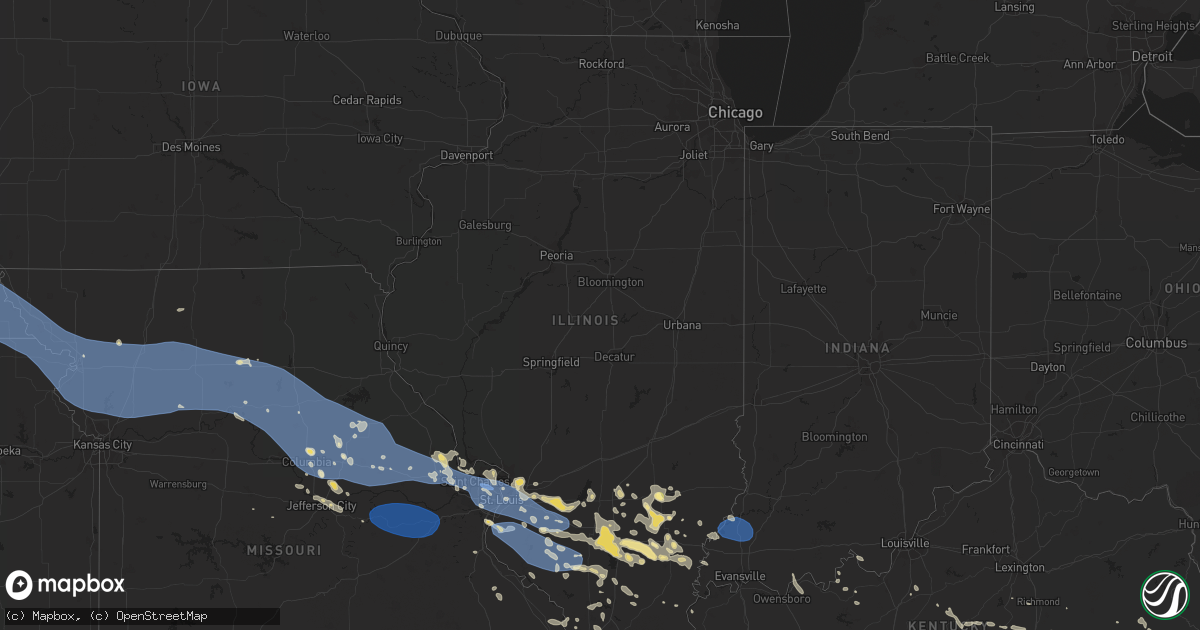
Hail Map in Illinois on July 29, 2023
Get this storm
July 29 map
$229
one time, instant access
Download today. No call, no setup
Keep the $229
Bought the map and want the full workflow? Apply the entire $229 to a subscription within 7 days. None of it is wasted.
Every map, not just this one
This buys you this map. Subscription and you get every map we run, in the markets you choose from a few cities to whole states to nationwide. Plus real-time alerts the moment a storm fires.
Contact data
Name, contact info, occupancy, even credit band for addresses in the footprint. You go from where it hit to who to call.
Become the source they trust
Unlimited branding weather history reports on demand. You already have the documented answer ready for the property owner, and you are the one who showed up with it.
Property data and RoofTrace estimates
Pull up any address you have got, its value and the exact code rules for that jurisdiction, straight from One Click Code. Then RoofTrace estimates the squares, pitch, and roof value, priced the way you price.
Storm reports in Illinois
Illinois
| Date | Description |
|---|---|
| 07/29/20236:42 PM CDT | Large tree down on road. Also minor wind damage to canopy near ridgway. |
| 07/29/20236:42 PM CDT | Trees and power lines down. Power outages widespread. |
| 07/29/20236:32 PM CDT | Large tree down. Also limbs down elsewhere in county. Measured gust 54 mph at round knob. |
| 07/29/20236:26 PM CDT | Large tree branch broken off. |
| 07/29/20236:10 PM CDT | Large tree down on barn. |
| 07/29/20236:00 PM CDT | Tree down on power line. |
| 07/29/20235:50 PM CDT | Trees... Limbs... And power lines down. |
| 07/29/20235:50 PM CDT | Large tree fell on a power line. |
| 07/29/20235:45 PM CDT | Tree down on a home. Also tree limbs down throughout the county. |
| 07/29/20235:45 PM CDT | Trees... Limbs... And power lines down. |
| 07/29/20235:45 PM CDT | Trees... Limbs... And power lines down. |
| 07/29/20235:45 PM CDT | Trees down countywide... Including west frankfort... Buckner... And benton. Tree down on van and camper in thompsonville. |
| 07/29/20235:40 PM CDT | Trees down and unknown damage to home near state route 37 and england rd. |
| 07/29/20235:40 PM CDT | Trees... Limbs... And power lines down. |
| 07/29/20235:39 PM CDT | Large trees down... Wind estimated 70 to 80 mph. |
| 07/29/20235:35 PM CDT | Trees... Limbs... And power lines down. |
| 07/29/20235:32 PM CDT | Multiple trees and large tree limbs down across town... Some on cars and several structures. |
| 07/29/20235:31 PM CDT | Large tree limbs down crab orchard campground. |
| 07/29/20235:29 PM CDT | Road sign blown across road. |
| 07/29/20235:28 PM CDT | Late report. Several trees down along with up to 6 inch limbs. |
| 07/29/20235:25 PM CDT | Tree down on a road in a park near gorham. |
| 07/29/20235:25 PM CDT | Photo powerlines downed by a large tree limb with several limbs littering the ground. Time estimated by radar. |
| 07/29/20235:20 PM CDT | Tree down on a house. |
| 07/29/20235:09 PM CDT | Multiple trees... Power lines... And power poles down across county. Much of county is without power. |
| 07/29/20235:09 PM CDT | Trees and power lines down. |
| 07/29/20235:00 PM CDT | Reports of trees and limbs down scattered about the town. |
| 07/29/20234:55 PM CDT | Report of four broken power poles within the city. |
| 07/29/20234:52 PM CDT | Corrects previous non-tstm wnd dmg report from 2 wnw steeleville. Several power poles down. |
| 07/29/20234:50 PM CDT | Ham radio relayed report of 4 inch diameter tulip tree being blown down. |
| 07/29/20234:50 PM CDT | Time estimate from radar. |
| 07/29/20234:47 PM CDT | Large tree branches down. |
| 07/29/20234:41 PM CDT | A local report indicates 73 MPH wind near 2 SE Swansea |
| 07/29/20234:40 PM CDT | Cwop report. |
| 07/29/20234:37 PM CDT | A local report indicates 63 MPH wind near Scott Afb |
| 07/29/20234:32 PM CDT | Observation relayed by st. Clair county skywarn. |
| 07/29/20234:30 PM CDT | Tree limbs down and roof damage. |
| 07/29/20234:28 PM CDT | 6 ft diameter tree snapped. Time estimated by radar. |
| 07/29/20234:27 PM CDT | Trees down. |
| 07/29/20234:26 PM CDT | Large tree snapped. Photos from social media. Time estimate from radar. |
| 07/29/20234:25 PM CDT | Trees down... Power poles snapped... And power lines down in fairview heights and ofallon il. A partial roof collapse in ofallon. |
| 07/29/20234:25 PM CDT | Large tree branches down. |
| 07/29/20234:25 PM CDT | Trees and limbs down. |
| 07/29/20234:24 PM CDT | 12 inch diameter tree limb blown down. Time estimated by radar. |
| 07/29/20234:22 PM CDT | A few 2 inch tree limbs down in the area. Spotter also noted a powerline was down a block away from their residence. Time estimated by radar. |
| 07/29/20234:22 PM CDT | Tree limbs down in the east alton area. Lost power in the area. Time estimated by radar. |
| 07/29/20234:21 PM CDT | Partial roof collapse... Potentially related to a downed tree branch. Time estimated from radar. |
| 07/29/20234:21 PM CDT | 6 inch tree limb down at wood river ave and first street. 4 inch tree limbs down along washington ave. Time estimated from radar. |
| 07/29/20234:21 PM CDT | Partial roof collapse from wind. Time estimated from radar. |
| 07/29/20234:20 PM CDT | Line down. |
| 07/29/20234:18 PM CDT | Trees and limbs down. |
| 07/29/20234:17 PM CDT | Cwop report. |
| 07/29/20234:17 PM CDT | Observation from the monroe county fairground near waterloo il. |
| 07/29/20234:15 PM CDT | Estimated 50-60 mph gusts. |
| 07/29/20234:13 PM CDT | A local report indicates 62 MPH wind near 2 W New Handover |
| 07/29/20234:10 PM CDT | Trees and limbs down. |
| 07/29/20234:10 PM CDT | Road signs down. |
| 07/29/20234:10 PM CDT | Wind gusts estimated near 60 mph. Time estimated by radar. |
| 07/29/20234:10 PM CDT | Trees down. |
| 07/29/20234:10 PM CDT | 5 to 8 inch tree limbs down near bethel road. Time estimated by radar. |
| 07/29/20234:07 PM CDT | 3-inch tree limbs broken; power poles broken. Time estimated by radar. |
| 07/29/20234:07 PM CDT | Large tree down. Photo sent in via social media. Time estimated by radar. |
| 07/29/20234:05 PM CDT | Trees and limbs down. |
| 07/29/20233:57 PM CDT | 6 in tree limb down. |
| 07/29/20233:53 PM CDT | Trees down on route 16 west of fieldon. |
All States Impacted by Hail Map on July 29, 2023
Cities Impacted by Hail Map on July 29, 2023
- Waterloo, IA
- Winthrop, IA
- Independence, IA
- Jesup, IA
- Dunkerton, IA
- Rowley, IA
- Fairbank, IA
- Brandon, IA
- Mount Auburn, IA
- Walker, IA
- Vinton, IA
- La Porte City, IA
- Atkins, IA
- Cedar Rapids, IA
- Center Point, IA
- Shellsburg, IA
- Quasqueton, IA
- Fairfax, IA
- Palo, IA
- Urbana, IA
- Durango, IA
- Bernard, IA
- Hopkinton, IA
- Coggon, IA
- Worthington, IA
- Central City, IA
- Robins, IA
- Delhi, IA
- Manchester, IA
- Marion, IA
- Ryan, IA
- Langworthy, IA
- Springville, IA
- Monticello, IA
- Alburnett, IA
- Farley, IA
- Dubuque, IA
- Earlville, IA
- Epworth, IA
- Peosta, IA
- Toddville, IA
- Dyersville, IA
- Anamosa, IA
- Cascade, IA
- Masonville, IA
- Prairieburg, IA
- Delaware, IA
- Hiawatha, IA
- Akron, CO
- Yuma, CO
- Joes, CO
- Cope, CO
- Tucson, AZ
- Cleveland, GA
- Clermont, GA
- Dahlonega, GA
- Murrayville, GA
- Dawsonville, GA
- Cartersville, GA
- Sutton, NE
- McCool Junction, NE
- York, NE
- Henderson, NE
- Grafton, NE
- Guide Rock, NE
- Edgar, NE
- Nelson, NE
- Superior, NE
- Bradshaw, NE
- Clay Center, NE
- Saronville, NE
- Oak, NE
- Geneva, NE
- Ong, NE
- Fairmont, NE
- Stromsburg, NE
- Benedict, NE
- Waco, NE
- Davenport, NE
- Shickley, NE
- Deshler, NE
- Ruskin, NE
- Hardy, NE
- Ohiowa, NE
- Strang, NE
- Carleton, NE
- Exeter, NE
- Bruning, NE
- Milligan, NE
- Tobias, NE
- Western, NE
- Gresham, NE
- Milford, NE
- Seward, NE
- Utica, NE
- Dorchester, NE
- Beaver Crossing, NE
- Crete, NE
- Friend, NE
- Cordova, NE
- Hebron, NE
- Belvidere, NE
- Daykin, NE
- Fairbury, NE
- Wilber, NE
- Alexandria, NE
- Swanton, NE
- Plymouth, NE
- De Witt, NE
- Jansen, NE
- Goehner, NE
- Pleasant Dale, NE
- Denton, NE
- Martell, NE
- Hallam, NE
- Cortland, NE
- Clatonia, NE
- Beatrice, NE
- Pickrell, NE
- Gilead, NE
- Steele City, NE
- Odell, NE
- Diller, NE
- Endicott, NE
- Blue Springs, NE
- Wymore, NE
- Sprague, NE
- Roca, NE
- Firth, NE
- Filley, NE
- Adams, NE
- Hickman, NE
- Bennet, NE
- Liberty, NE
- Virginia, NE
- Panama, NE
- Lincoln, NE
- Crab Orchard, NE
- Tecumseh, NE
- Douglas, NE
- Sterling, NE
- Palmyra, NE
- Burr, NE
- Unadilla, NE
- Syracuse, NE
- Cook, NE
- Elk Creek, NE
- Lewiston, NE
- Steinauer, NE
- Burchard, NE
- Talmage, NE
- Johnson, NE
- Auburn, NE
- Table Rock, NE
- Humboldt, NE
- Brock, NE
- Pawnee City, NE
- Brownville, NE
- Julian, NE
- Du Bois, NE
- Peru, NE
- Nebraska City, NE
- Dawson, NE
- Stella, NE
- Nemaha, NE
- Salem, NE
- Verdon, NE
- Shubert, NE
- Falls City, NE
- Rock Port, MO
- Fairfax, MO
- Craig, MO
- Rulo, NE
- Mound City, MO
- Forest City, MO
- Hiawatha, KS
- Sabetha, KS
- Morrill, KS
- White Cloud, KS
- Maitland, MO
- Oregon, MO
- Fillmore, MO
- Saint Joseph, MO
- Robinson, KS
- Wathena, KS
- Highland, KS
- Amazonia, MO
- Savannah, MO
- Troy, KS
- Cosby, MO
- Elwood, KS
- Barneston, NE
- Easton, MO
- Stewartsville, MO
- Agency, MO
- Clarksdale, MO
- Helena, MO
- Rosendale, MO
- Union Star, MO
- Maysville, MO
- Amity, MO
- Gower, MO
- Faucett, MO
- Denton, KS
- Bendena, KS
- Rushville, MO
- Dearborn, MO
- De Kalb, MO
- Atchison, KS
- Weston, MO
- Leavenworth, KS
- Platte City, MO
- Camden Point, MO
- Osborn, MO
- Edgerton, MO
- Winston, MO
- Smithville, MO
- Weatherby, MO
- Cameron, MO
- Trimble, MO
- Plattsburg, MO
- Lathrop, MO
- Turney, MO
- Excelsior Springs, MO
- Kearney, MO
- Holt, MO
- Liberty, MO
- Kingston, MO
- Gallatin, MO
- Hamilton, MO
- Altamont, MO
- Kidder, MO
- Polo, MO
- Lawson, MO
- Rayville, MO
- Cowgill, MO
- Richmond, MO
- Hardin, MO
- Braymer, MO
- Norborne, MO
- Breckenridge, MO
- Ludlow, MO
- Jamesport, MO
- Carrollton, MO
- Dawn, MO
- Bogard, MO
- Lock Springs, MO
- Chillicothe, MO
- Mooresville, MO
- Utica, MO
- Tina, MO
- Hale, MO
- Brunswick, MO
- Triplett, MO
- De Witt, MO
- Bosworth, MO
- Sumner, MO
- Slater, MO
- Dalton, MO
- Miami, MO
- Meadville, MO
- Wheeling, MO
- Mendon, MO
- Salisbury, MO
- Keytesville, MO
- Glasgow, MO
- Chula, MO
- Brookfield, MO
- Rothville, MO
- Laclede, MO
- Marceline, MO
- Linneus, MO
- New Cambria, MO
- Bucklin, MO
- Armstrong, MO
- Fayette, MO
- Clifton Hill, MO
- Callao, MO
- Huntsville, MO
- Bevier, MO
- Excello, MO
- Higbee, MO
- Rocheport, MO
- Columbia, MO
- Harrisburg, MO
- Macon, MO
- Sturgeon, MO
- Moberly, MO
- Cairo, MO
- Clark, MO
- Ashland, MO
- Hallsville, MO
- Centralia, MO
- Jacksonville, MO
- Madison, MO
- Holliday, MO
- Freedom, NH
- Madison, NH
- Brownfield, ME
- Porter, ME
- Ashley, IL
- Mount Vernon, IL
- Dix, IL
- Marissa, IL
- Saint Libory, IL
- Mascoutah, IL
- Ewing, IL
- Belle Rive, IL
- Ina, IL
- Carmi, IL
- Enfield, IL
- Nashville, IL
- Hoyleton, IL
- Waltonville, IL
- Woodlawn, IL
- Whigham, GA
- Cairo, GA
- McLeansboro, IL
- Pelham, GA
- Bonnie, IL
- Du Bois, IL
- Dahlgren, IL
- Springerton, IL
- New Harmony, IN
- Hartville, MO
- Bradfordsville, KY
- Gravel Switch, KY
- Macedonia, IL
- Opdyke, IL
- Carrier Mills, IL
- Marion, IL
- Lenzburg, IL
- Addieville, IL
- Keenes, IL
- Polk, NE
- Centralia, IL
- Scheller, IL
- Walnut Hill, IL
- Okawville, IL
- Oakdale, IL
- Whittington, IL
- Wayne City, IL
- Fulton, MO
- Thompson, MO
- Paris, MO
- Rush Hill, MO
- Mexico, MO
- Kingdom City, MO
- Auxvasse, MO
- Perry, MO
- Santa Fe, MO
- Laddonia, MO
- Benton City, MO
- Goffstown, NH
- Manchester, NH
- Farber, MO
- Vandalia, MO
- Martinsburg, MO
- Williamsburg, MO
- Montgomery City, MO
- Steedman, MO
- Wellsville, MO
- Portland, MO
- Rhineland, MO
- New Florence, MO
- Middletown, MO
- Warrenton, MO
- Truxton, MO
- Jonesburg, MO
- Bellflower, MO
- High Hill, MO
- Hermann, MO
- Hawk Point, MO
- Troy, MO
- Wright City, MO
- Silex, MO
- Moscow Mills, MO
- Truesdale, MO
- Foristell, MO
- Busy, KY
- Bulan, KY
- Hyden, KY
- Hazard, KY
- Bonnyman, KY
- Wooton, KY
- Krypton, KY
- Hindman, KY
- Combs, KY
- Carrie, KY
- Delphia, KY
- Smilax, KY
- Linefork, KY
- Viper, KY
- Partridge, KY
- Cornettsville, KY
- Slemp, KY
- Happy, KY
- Neon, KY
- Deane, KY
- Seco, KY
- Vicco, KY
- Sassafras, KY
- Whitesburg, KY
- Letcher, KY
- Jenkins, KY
- Jeff, KY
- Millstone, KY
- Thornton, KY
- Yeaddiss, KY
- Eolia, KY
- Ermine, KY
- Jeremiah, KY
- Mayking, KY
- Benham, KY
- Premium, KY
- Pine Top, KY
- Mallie, KY
- Redfox, KY
- Scuddy, KY
- Cumberland, KY
- Lynch, KY
- Hallie, KY
- Blackey, KY
- Gordon, KY
- Roxana, KY
- Littcarr, KY
- Isom, KY
- Helton, KY
- Wendover, KY
- Evarts, KY
- Stinnett, KY
- Putney, KY
- Chappell, KY
- Baxter, KY
- Mozelle, KY
- Bledsoe, KY
- Big Laurel, KY
- Essie, KY
- Warbranch, KY
- Totz, KY
- Dwarf, KY
- Emmalena, KY
- Morrison, MO
- Bland, MO
- Mount Sterling, MO
- Owensville, MO
- Gerald, MO
- Washington, MO
- Leslie, MO
- Rosebud, MO
- Berger, MO
- New Haven, MO
- Union, MO
- Beaufort, MO
- Clarence, MO
- Boyds, MD
- Clarksburg, MD
- Damascus, MD
- Gaithersburg, MD
- Germantown, MD
- Mount Airy, MD
- Dickerson, MD
- Barnesville, MD
- Sullivan, MO
- Villa Ridge, MO
- Saint Clair, MO
- Saint Peters, MO
- Saint Charles, MO
- O'Fallon, MO
- Wentzville, MO
- Lake Saint Louis, MO
- Old Monroe, MO
- Maryland Heights, MO
- Saint Louis, MO
- Glen Echo, MD
- Potomac, MD
- Cabin John, MD
- Bethesda, MD
- Washington, DC
- Chevy Chase, MD
- Earth City, MO
- Hazelwood, MO
- Bridgeton, MO
- Florissant, MO
- Chesterfield, MO
- Saint Ann, MO
- Alexandria, VA
- Falls Church, VA
- Arlington, VA
- Annandale, VA
- McLean, VA
- Capitol Heights, MD
- Oxon Hill, MD
- Clinton, MD
- Suitland, MD
- Andrews Air Force Base, MD
- Upper Marlboro, MD
- Fort Washington, MD
- Temple Hills, MD
- District Heights, MD
- Naval Anacost Annex, DC
- Bowie, MD
- Annapolis, MD
- Edgewater, MD
- Gambrills, MD
- Odenton, MD
- Crownsville, MD
- Crofton, MD
- Davidsonville, MD
- Riva, MD
- Shady Side, MD
- Galesville, MD
- West River, MD
- Harwood, MD
- Fort Myer, VA
- Ballwin, MO
- East Saint Louis, IL
- Lovejoy, IL
- Madison, IL
- East Carondelet, IL
- Granite City, IL
- Venice, IL
- Fairview Heights, IL
- Lebanon, IL
- Belleville, IL
- O'Fallon, IL
- Troy, IL
- Dupo, IL
- Collinsville, IL
- Caseyville, IL
- Millstadt, IL
- Freeburg, IL
- Scott Air Force Base, IL
- Waterloo, IL
- Valmeyer, IL
- Columbia, IL
- Smithton, IL
- New Athens, IL
- Red Bud, IL
- Hecker, IL
- Flora, IL
- Clay City, IL
- Chestertown, MD
- Worton, MD
- Millington, MD
- Still Pond, MD
- Kennedyville, MD
- Stevensville, MD
- Claiborne, MD
- Mcdaniel, MD
- Wittman, MD
- Saint Michaels, MD
- Bozman, MD
- Sherwood, MD
- Royal Oak, MD
- Neavitt, MD
- New Baden, IL
- Trenton, IL
- Albers, IL
- Bartelso, IL
- Waynesville, NC
- Model, CO
- Aurora, MO
- Marionville, MO
- Galena, MD
- Massey, MD
- Clayton, DE
- Townsend, DE
- Crumpton, MD
- Chester, IL
- Walsh, IL
- Coulterville, IL
- Pinckneyville, IL
- Ellis Grove, IL
- Evansville, IL
- Steeleville, IL
- Du Quoin, IL
- Percy, IL
- Sparta, IL
- Tilden, IL
- Tamaroa, IL
- Cutler, IL
- Baldwin, IL
- Rehoboth Beach, DE
- Brooklyn, CT
- Marine, IL
- Edwardsville, IL
- Saint Jacob, IL
- Brussels, IL
- Golden Eagle, IL
- Sainte Genevieve, MO
- Fairfield, IL
- Girdler, KY
- Hinkle, KY
- Cannon, KY
- Barbourville, KY
- Rogersville, MO
- Albany, KY
- Byrdstown, TN
- Clanton, AL
- Jemison, AL
- Nokesville, VA
- Gainesville, VA
- Bristow, VA
- Bedford, NH
- New Bloomfield, MO
- Ashburn, VA
- Leesburg, VA
- Farmington, MO
- Forest, MS
- Allensville, KY
- Ceres, VA
- Glen Arm, MD
- Abingdon, MD
- Hydes, MD
- Phoenix, MD
- Kingsville, MD
- Gunpowder, MD
- Edgewood, MD
- Joppa, MD
- Nottingham, MD
- White Marsh, MD
- Upper Falls, MD
- Fallston, MD
- Fork, MD
- Baldwin, MD
- Perry Hall, MD
- Eidson, TN
- Rogersville, TN
- Sneedville, TN
- Pelahatchie, MS
- Pall Mall, TN
- Ten Mile, TN
- Kingston, TN
- Rockwood, TN
- Booneville, KY
- Ricetown, KY
- McKee, KY
- Port Tobacco, MD
- La Plata, MD
- Jackson, KY
- Carterville, IL
- Bluford, IL
- Iuka, IL
- Salem, IL
- Dante, VA
- Bee, VA
- Cleveland, VA
- Monticello, KY
- Springfield, TN
- Greenbrier, TN
- Vest, KY
- Rocky Top, TN
- Jacksboro, TN
- Caryville, TN
- Morton, MS
- Brandon, MS
- Cottontown, TN
- Cross Plains, TN
- New Tazewell, TN
- Sharps Chapel, TN
- Speedwell, TN
- Tebbetts, MO
- Bonnots Mill, MO
- Jefferson City, MO
- Hartsburg, MO
- Holts Summit, MO
- La Vergne, TN
- Mount Juliet, TN
- Lebanon, TN
- Hermitage, TN
- Crawford, TN
- Allred, TN
- Rickman, TN
- Grand Tower, IL
- Wolf Lake, IL
- Carlyle, IL
- Jackson, MO
- Portland, TN
- Westmoreland, TN
- Bethpage, TN
- Mulkeytown, IL
- Spickard, MO
- Kingman, AZ
- Hackberry, AZ
- La Follette, TN
- Scottsville, KY
- Adolphus, KY
- Duffield, VA
- Goodlettsville, TN
- Joelton, TN
- Whites Creek, TN
- Cape Girardeau, MO
- Mokane, MO
- Winfield, MO
- Castlewood, VA
- Lebanon, VA
- Somerset, KY
- Burnside, KY
- Millersville, MO
- Marble Hill, MO
- Thorsby, AL
- Saint Paul, VA
- Kyles Ford, TN
- Springfield, KY
- Lebanon, KY
- Johnston City, IL
- West Frankfort, IL
- Thompsonville, IL
- Pittsburg, IL
- Magee, MS
- Mendenhall, MS
- Alto Pass, IL
- Jakin, GA
- Donalsonville, GA
- Annville, KY
- Tyner, KY
- Knoxville, TN
- Heiskell, TN
- Arnold, MO
- Gray, KY
- Lake, MS
- Andersonville, TN
- Maynardville, TN
- Liberty, KY
- Pinola, MS
- Stanford, KY
- Crab Orchard, KY
- Birchleaf, VA
- Clinchco, VA
- Haysi, VA
- Glen Carbon, IL
- Verona, MO
- Christopher, IL
- Sesser, IL
- Benton, IL
- Royalton, IL
- Jamestown, TN
- Altenburg, MO
- Pulaski, MS
- Nashville, TN
- Bowman, ND
- Irvine, KY
- Alma, IL
- Laurel, MD
- Richmond, KY
- Atkins, VA
- Auburn, KY
- Jamestown, MO
- Centertown, MO
- Raton, NM
- Woodburn, KY
- Bowling Green, KY
- Johnsonville, IL
- Carbondale, IL
- Newark, DE
- Woodstown, NJ
- Bear, DE
- New Castle, DE
- Pennsville, NJ
- Salem, NJ
- Xenia, IL
- Hendersonville, TN
- White House, TN
- Lily, KY
- London, KY
- Corbin, KY
- Burkesville, KY
- Tompkinsville, KY
- Columbiana, AL
- Shelby, AL
- Versailles, MO
- Walsenburg, CO
- Lorton, VA
- Fort Belvoir, VA
- Crane, MO
- Springfield, VA
- Elkville, IL
- Parksville, KY
- White Plains, MD
- Waldorf, MD
- Max Meadows, VA
- Draper, VA
- Harriman, TN
- Nicholasville, KY
- Russellville, TN
- Whitesburg, TN
- Accokeek, MD
- Batchtown, IL
- Foley, MO
- Harrogate, TN
- Tazewell, TN
- Breese, IL
- Aviston, IL
- Germantown, IL
- Livingston, TN
- Mooresburg, TN
- Maryville, IL
- West Blocton, AL
- Alvaton, KY
- Fountain Run, KY
- Franklin, KY
- Billings, MO
- Manchester, KY
- Hiram, ME
- Sedalia, CO
- Ashford, AL
- Thaxton, VA
- Geff, IL
- Rinard, IL
- Cisne, IL
- Sims, IL
- Hilham, TN
- Allons, TN
- Ava, IL
- Campbell Hill, IL
- Burfordville, MO
- Fairfax, VA
- Bryans Road, MD
- Vienna, VA
- Clifton, VA
- Great Falls, VA
- Burke, VA
- Dunn Loring, VA
- Woodbridge, VA
- Fairfax Station, VA
- Indian Head, MD
- Weogufka, AL
- Phenix City, AL
- Mountain Grove, MO
- Stuart, VA
- Galatia, IL
- Carthage, MO
- Jasper, MO
- Golden City, MO
- Surgoinsville, TN
- Gate City, VA
- Church Hill, TN
- Abingdon, VA
- Junction City, KY
- Kite, KY
- Topmost, KY
- Greenback, TN
- Maryville, TN
- Herrin, IL
- Energy, IL
- Windsor, KY
- Philadelphia, TN
- Wallins Creek, KY
- Harlan, KY
- Gordon, AL
- Jamestown, KY
- Russell Springs, KY
- Barnhill, IL
- Bristol, VA
- Sextons Creek, KY
- Clarksville, TN
- Mount Airy, NC
- West Alton, MO
- Monroe, TN
- Buckhorn, KY
- Sizerock, KY
- Thousandsticks, KY
- Bear Branch, KY
- Oneida, KY
- Glade Valley, NC
- Gamaliel, KY
- Freistatt, MO
- Mill Shoals, IL
- Crossville, IL
- Burnt Prairie, IL
- Norwood, MO
- Ava, MO
- Anna, IL
- Lake George, CO
- Festus, MO
- Mount Vernon, KY
- Berea, KY
- Sentinel Butte, ND
- Beach, ND
- Fairfield, ND
- Ludlow, SD
- East Bridgewater, MA
- Brockton, MA
- South Easton, MA
- West Bridgewater, MA
- Sand Coulee, MT
- Belt, MT
- Great Falls, MT
- Mount Carmel, IL
- Patoka, IN
- Owensville, IN
- Hazleton, IN
- Princeton, IN
- Francisco, IN
- Decker, IN
- Fort Branch, IN
- Fredonia, KY
- Princeton, KY
- Dawson Springs, KY
- Gainesville, MO
- Brixey, MO
- Squires, MO
- Noble, MO
- Zanoni, MO
- Wasola, MO
- Thornfield, MO
- Hardenville, MO
- Crofton, KY
- Saint Charles, KY
- White Plains, KY
- Cerulean, KY
- Hopkinsville, KY
- Rockvale, CO
- Canon City, CO
- Wetmore, CO
- Florence, CO
- Orchard, CO
- Grassy Butte, ND
- Killdeer, ND
- Dunn Center, ND
- Medora, ND
- Belfield, ND
- New England, ND
- Amidon, ND
- Rhame, ND
- Geyser, MT
- Geraldine, MT
- Highwood, MT
- Elkton, KY
- Pembroke, KY
- Eddyville, KY
- Herndon, KY
- Trenton, KY
- Cadiz, KY
- Oak Grove, KY
- Gracey, KY
- Solomons, MD
- Lexington Park, MD
- Great Mills, MD
- Callaway, MD
- California, MD
- Patuxent River, MD
- Saint Inigoes, MD
- Drayden, MD
- Ridge, MD
- Dameron, MD
- Valley Lee, MD
- Scotland, MD
- Park Hall, MD
- Lusby, MD
- Bennett, CO
- Halliday, ND
- Scranton, ND
- Reva, SD
- Prairie City, SD
- Mud Butte, SD
- Faith, SD
- Buffalo, SD
- Newell, SD
- Enning, SD
- Union Center, SD
- White Owl, SD
- Moccasin, MT
- Moore, MT
- Lewistown, MT
- Hobson, MT
- Grass Range, MT
- Wall, SD
- Howes, SD
- Wasta, SD
- Forest Grove, MT
- Winnett, MT
- Quinn, SD
- Philip, SD
- Colorado City, CO
- Penrose, CO
- Pueblo, CO
- Beulah, CO
- Rye, CO
- Avondale, CO
- Walnut Ridge, AR
- Beech Grove, AR
- Bono, AR
- Ararat, NC
- Dobson, NC
- Oak Ridge, TN
- Union Star, KY
- Lynch Station, VA
- Irvington, KY
- Pamplin, VA
- Appomattox, VA
- Marion, NC
- Denton, MT
- Statesville, NC
- Marietta, SC
- Cleveland, SC
- Cumberland Furnace, TN
- Cumberland City, TN
- Vanleer, TN
- Boston, KY
- Lebanon Junction, KY
- Shepherdsville, KY
- Dillwyn, VA
- Fordland, MO
- Bruner, MO
- Lucedale, MS
- Thayer, MO
- Mammoth Spring, AR
- Koshkonong, MO
- Sonoita, AZ
- Vail, AZ
- Rousseau, KY
- Springfield, MO
- West Plains, MO
- Hurt, VA
- Penhook, VA
- Union Hall, VA
- Sandy Level, VA
- Caret, VA
- Guffey, CO
- Buena Vista, GA
- Americus, GA
- Plains, GA
- Shellman, GA
- Ellaville, GA
- Chestnut Mound, TN
- Elmwood, TN
- Georgetown, DE
- Elberfeld, IN
- Lynnville, IN
- Oakland City, IN
- Chatham, VA
- Keeling, VA
- Sparta, MO
- Ozark, MO
- Chadwick, MO
- Oldfield, MO
- Sturgis, KY
- Norris, TN
- Gretna, VA
- Elkin, NC
- Columbia, AL
- Headland, AL
- Webb, AL
- East Bend, NC
- Higden, AR
- Bridgeville, DE
- Seaford, DE
- Edgemont, AR
- Shirley, AR
- Hustle, VA
- Port Royal, VA
- Dale, IN
- Lancaster, KY
- Batesville, AR
- Marcella, AR
- Locust Grove, AR
- Kinmundy, IL
- Ferrum, VA
- Mountain Home, AR
- Lynchburg, MO
- Monett, MO
- Mount Vernon, MO
- Camden, MS
- Williamsburg, KY
- Doniphan, MO
- Gatewood, MO
- Preston, GA
- Richland, GA
- Weston, GA
- Graff, MO
- Boonville, NC
- Dewey, AZ
- Prescott Valley, AZ
- Reliance, TN
- Aurora, NE
- Tiptonville, TN
- Ridgely, TN
- Bryantown, MD
- Equality, IL
- Harrisburg, IL
- Kell, IL
- Junction, IL
- Louisville, IL
- Noble, IL
- Honaker, VA
- Chandler, IN
- Evansville, IN
- Calvert City, KY
- Mistletoe, KY
- Buckingham, VA
- Scottsville, VA
- Howardsville, VA
- Salem, KY
- Siloam, NC
- Irvington, IL
- Richview, IL
- Harned, KY
- Garfield, KY
- Vernon Hill, VA
- Java, VA
- Pocahontas, AR
- Golden Gate, IL
- Occoquan, VA
- Pomfret, MD
- Philpot, KY
- Grandview, IN
- Lewisport, KY
- Maceo, KY
- Opelika, AL
- Salem, AL
- Pippa Passes, KY
- Bone Gap, IL
- Albion, IL
- Texico, IL
- Seale, AL
- Warsaw, VA
- Hardinsburg, KY
- Webster, KY
- Thurmond, NC
- Roaring Gap, NC
- Haubstadt, IN
- Oakman, AL
- Sparta, TN
- Mayfield, KY
- Stearns, KY
- Pinnacle, NC
- Millsboro, DE
- Showell, MD
- Frankford, DE
- Delmar, DE
- Whaleyville, MD
- Willards, MD
- Laurel, DE
- Bishopville, MD
- Berlin, MD
- Loretto, KY
- Altha, FL
- Fountain, FL
- Canton, MS
- Dawson, GA
- State Road, NC
- Cynthiana, IN
- Stephensport, KY
- Marbury, MD
- Bunnell, FL
- Antioch, TN
- Mauckport, IN
- Central, IN
- Battletown, KY
- Columbus, NC
- Mill Spring, NC
- Cartersville, VA
- Cumberland, VA
- Powhatan, VA
- Buncombe, IL
- Gladstone, VA
- Bradleyville, MO
- Garrison, MO
- Sandgap, KY
- Nixa, MO
- Denton, MD
- Lake City, AR
- Woodford, VA
- Spotsylvania, VA
- Fredericksburg, VA
- Ellery, IL
- Henry, VA
- East Flat Rock, NC
- Flat Rock, NC
- Hendersonville, NC
- Bowersville, GA
- Hartwell, GA
- Mountain View, AR
- Benton, KY
- Symsonia, KY
- Huddleston, VA
- Kadoka, SD
- Ingomar, MT
- Carthage, TN
- Winifred, MT
- Berthold, ND
- Des Lacs, ND
- Matheson, CO
- Reeder, ND
- Cunningham, TN
- Stanley, ND
- Calhan, CO
- Tecumseh, MO
- Zahl, ND
- Seymour, MO
- Plaza, ND
- Grenora, ND
- Long Valley, SD
- Fairburn, GA
- White River, SD
- Palermo, ND
- Cobden, IL
- Makanda, IL
- Clarkridge, AR
- Corydon, IN
- Decatur, GA
- Ellenwood, GA
- Mansfield, MO
- Browns, IL
- Ross, ND
- Wilder, TN
- Macon, GA
- Wanblee, SD
- Oak Ridge, MO
- Atlanta, GA
- Smyrna, GA
- Marietta, GA
- Parshall, ND
- Garrison, ND
- Roseglen, ND
- Clinton, TN
- Marshfield, MO
- Strafford, MO
- Naylor, MO
- Hinsdale, MT
- Richland, MT
- Opheim, MT
- Peerless, MT
- Larslan, MT
- Glentana, MT
- Scobey, MT
- Wolf Point, MT
- Frazer, MT
- Poplar, MT
- Brockton, MT
- Flaxville, MT
- Homestead, MT
- Medicine Lake, MT
- Froid, MT
- Richardton, ND
- Hebron, ND
- New Leipzig, ND
- Glen Ullin, ND
- Elgin, ND
- Carson, ND
- Dagmar, MT
- Antelope, MT
- Reserve, MT
- Musselshell, MT
- Wood River, NE
- Williston, ND
- Bainville, MT
- Westby, MT
- Benton, TN
- Vonore, TN
- Savannah, TN
- Prim, AR
- Almont, ND
- New Salem, ND
- Taylor, ND
- Flasher, ND


