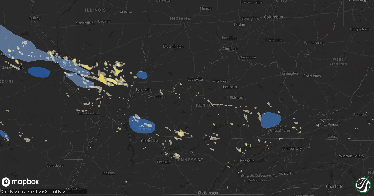
Hail Map in Kentucky on July 29, 2023
Get this storm
July 29 map
$229
one time, instant access
Download today. No call, no setup
Keep the $229
Bought the map and want the full workflow? Apply the entire $229 to a subscription within 7 days. None of it is wasted.
Every map, not just this one
This buys you this map. Subscription and you get every map we run, in the markets you choose from a few cities to whole states to nationwide. Plus real-time alerts the moment a storm fires.
Contact data
Name, contact info, occupancy, even credit band for addresses in the footprint. You go from where it hit to who to call.
Become the source they trust
Unlimited branding weather history reports on demand. You already have the documented answer ready for the property owner, and you are the one who showed up with it.
Property data and RoofTrace estimates
Pull up any address you have got, its value and the exact code rules for that jurisdiction, straight from One Click Code. Then RoofTrace estimates the squares, pitch, and roof value, priced the way you price.
Storm reports in Kentucky
Kentucky
| Date | Description |
|---|---|
| 07/29/20236:58 PM CDT | Tree through roof of apartment. Also tree limb on power line near hendron. |
| 07/29/20236:50 PM CDT | Trees down on roads. |
| 07/29/20236:40 PM CDT | Large limbs down. |
| 07/29/20235:38 PM CDT | Tree down on the 400 block of fox lane. |
| 07/29/20235:38 PM CDT | A tree blew down which brought a light pole down on the 200 block of stephens ridge road. |
| 07/29/20235:38 PM CDT | A tree fell on half acre road near the sewer plant. |
| 07/29/20233:27 PM CDT | County dispatch reported a tree downed into power lines along ky-1643. Time estimated from radar. |
| 07/29/20233:26 PM CDT | Corrects previous tstm wnd dmg report from 1 n varilla. Wril reported a snapped power pole on ky-987 near the intersection of baker hill rd |
| 07/29/20233:26 PM CDT | Wril reported a snapped power pole on ky-987 near the intersection of baker hill rd |
| 07/29/20233:16 PM CDT | County dispatch reported trees blown down into power lines along ky-3001 in front of the harlan country club. Time estimated from radar. |
| 07/29/20233:12 PM CDT | Picture on social media shows several large limbs down in yard along baker street. Time estimated from radar. |
| 07/29/20233:09 PM CDT | County dispatch reported several trees blown down into power lines in the holiday acres trailer park. Time estimated from radar. |
| 07/29/20233:06 PM CDT | Corrects previous tstm wnd dmg report from rosspoint. Pictures on social media shows half a large deciduous tree blown down into power lines along engle drive. Time est |
| 07/29/20233:04 PM CDT | Amateur radio operator reports downed tree on ky-413 leading to a power outage in the rosspoint area of baxter. Event time estimated from radar. |
| 07/29/20233:03 PM CDT | A member of the public shared a picture of a large tree snapped and fallen across ky-588 about halfway between roxana and blackey. The tree trunk was still suspended in |
| 07/29/20233:02 PM CDT | Trees were down on multiple county roads. |
| 07/29/20232:49 PM CDT | Wxkq relayed a social media report showing a large tree down on the camp branch side of thornton in the vicinity of tim hall timber trucking. Time estimated from radar. |
| 07/29/20232:48 PM CDT | Scattered trees and power lines down including on walker street. Some city vehicles were damaged from the falling trees. |
| 07/29/20232:45 PM CDT | County dispatch reported a tree blown down and blocking 1 lane of us-421 around mm 11. Time estimated from radar. |
| 07/29/20232:36 PM CDT | Knott county dispatch relayed a report of a down tree into the powerlines near the intersection of hwy 160 and hwy 899. Time estimated from radar. |
| 07/29/20232:35 PM CDT | Kytc district 12 reported that ky-160 near the ky-899 intersection was closed due to a tree fall. Power and telephone lines were involved. Event time estimated from rad |
| 07/29/20232:31 PM CDT | County dispatch reported tree blown down blocking one lane of davidson fork rd. |
| 07/29/20232:27 PM CDT | Magoffin county dispatch relayed a report of a down tree near mile marker 4 on south river road. Time estimated from radar. |
| 07/29/20232:26 PM CDT | County dispatch reported a beech tree blown down onto a powerline blocking both lanes of traffic on dryhill rd. Time estimate from radar. |
| 07/29/20232:22 PM CDT | County dispatch reported a power pole split by fallen tree along us-421 near mm 26. Time estimated by radar. |
| 07/29/20232:18 PM CDT | Off-duty nws estimated winds of 60 mph in hazard. |
| 07/29/20232:18 PM CDT | Social media report of metal awning damage near the 300 block of main street in hazard. Time estimated from radar. |
| 07/29/20232:15 PM CDT | County dispatch reported powerlines blown down along whitaker fork rd. Time estimated from radar. |
| 07/29/20232:14 PM CDT | County dispatch reported powerlines blown down near the intersection of oakhurst avenue and brown street. Time estimate from radar. |
| 07/29/20232:13 PM CDT | County dispatch reported power lines blown down along browns fork rd. Time estimated from radar. |
| 07/29/20232:13 PM CDT | County dispatch reported a tree blown down in the 4300 block of ky-15 n in the vicinity of bonnyman. Time estimated from radar. |
| 07/29/20232:10 PM CDT | County dispatch reported a tree blown down on coal harbor lane. Time estimated from radar. |
| 07/29/20232:10 PM CDT | County dispatch reported powerlines blown down in the 2300 block of big willard rd. Near busy. Time estimated from radar. |
| 07/29/20232:04 PM CDT | County dispatch received multiple reports of a tree blown down on big cave road |
| 07/29/20231:51 PM CDT | County dispatch reported 2 trees blown down on renfro creek rd. One tree was large and laid across the entire highway near the intersection with hurricane school rd. Th |
| 07/29/20231:42 PM CDT | Breathitt county dispatch reported a tree down at the intersection of knack branch and stray branch rd. Time estimated via radar. |
| 07/29/20231:24 PM CDT | Estill county dispatch relayed a report of tree down on millers creek rd near the railroad crossing. Time estimated from radar. |
| 07/29/20231:19 PM CDT | Individual on social media shared picture of large limb broken off a tree in the 3100 block of tipton ridge rd. Time estimated. |
| 07/29/20237:01 AM CDT | Magoffin county dispatch relayed a report of a down tree near mile marker 2 on litteral fork rd. Time estimated from radar. |
| 07/28/20239:30 PM CDT | Trees down along highway 376. Time estimated by radar. |
| 07/28/20239:30 PM CDT | Trees down along highway 376 |
| 07/28/20239:10 PM CDT | Tree down blocking west main street in auburn... Ky. |
| 07/28/20238:55 PM CDT | Trees down on homes on radio station road and saint rose road. There is damage to a barn and roof off of a house on saint rose road in lebanon. Timing is best guess fro |
| 07/28/20238:15 PM CDT | At least a few trees down... Including one on a house. Power outages. |
| 07/28/20238:10 PM CDT | Measured at kentucky mesonet site. |
| 07/28/20237:45 PM CDT | Kentucky mesonet site. |
| 07/28/20237:39 PM CDT | A local report indicates 60 MPH wind near 6 SW Fryer |
All States Impacted by Hail Map on July 29, 2023
Cities Impacted by Hail Map on July 29, 2023
- Waterloo, IA
- Winthrop, IA
- Independence, IA
- Jesup, IA
- Dunkerton, IA
- Rowley, IA
- Fairbank, IA
- Brandon, IA
- Mount Auburn, IA
- Walker, IA
- Vinton, IA
- La Porte City, IA
- Atkins, IA
- Cedar Rapids, IA
- Center Point, IA
- Shellsburg, IA
- Quasqueton, IA
- Fairfax, IA
- Palo, IA
- Urbana, IA
- Durango, IA
- Bernard, IA
- Hopkinton, IA
- Coggon, IA
- Worthington, IA
- Central City, IA
- Robins, IA
- Delhi, IA
- Manchester, IA
- Marion, IA
- Ryan, IA
- Langworthy, IA
- Springville, IA
- Monticello, IA
- Alburnett, IA
- Farley, IA
- Dubuque, IA
- Earlville, IA
- Epworth, IA
- Peosta, IA
- Toddville, IA
- Dyersville, IA
- Anamosa, IA
- Cascade, IA
- Masonville, IA
- Prairieburg, IA
- Delaware, IA
- Hiawatha, IA
- Akron, CO
- Yuma, CO
- Joes, CO
- Cope, CO
- Tucson, AZ
- Cleveland, GA
- Clermont, GA
- Dahlonega, GA
- Murrayville, GA
- Dawsonville, GA
- Cartersville, GA
- Sutton, NE
- McCool Junction, NE
- York, NE
- Henderson, NE
- Grafton, NE
- Guide Rock, NE
- Edgar, NE
- Nelson, NE
- Superior, NE
- Bradshaw, NE
- Clay Center, NE
- Saronville, NE
- Oak, NE
- Geneva, NE
- Ong, NE
- Fairmont, NE
- Stromsburg, NE
- Benedict, NE
- Waco, NE
- Davenport, NE
- Shickley, NE
- Deshler, NE
- Ruskin, NE
- Hardy, NE
- Ohiowa, NE
- Strang, NE
- Carleton, NE
- Exeter, NE
- Bruning, NE
- Milligan, NE
- Tobias, NE
- Western, NE
- Gresham, NE
- Milford, NE
- Seward, NE
- Utica, NE
- Dorchester, NE
- Beaver Crossing, NE
- Crete, NE
- Friend, NE
- Cordova, NE
- Hebron, NE
- Belvidere, NE
- Daykin, NE
- Fairbury, NE
- Wilber, NE
- Alexandria, NE
- Swanton, NE
- Plymouth, NE
- De Witt, NE
- Jansen, NE
- Goehner, NE
- Pleasant Dale, NE
- Denton, NE
- Martell, NE
- Hallam, NE
- Cortland, NE
- Clatonia, NE
- Beatrice, NE
- Pickrell, NE
- Gilead, NE
- Steele City, NE
- Odell, NE
- Diller, NE
- Endicott, NE
- Blue Springs, NE
- Wymore, NE
- Sprague, NE
- Roca, NE
- Firth, NE
- Filley, NE
- Adams, NE
- Hickman, NE
- Bennet, NE
- Liberty, NE
- Virginia, NE
- Panama, NE
- Lincoln, NE
- Crab Orchard, NE
- Tecumseh, NE
- Douglas, NE
- Sterling, NE
- Palmyra, NE
- Burr, NE
- Unadilla, NE
- Syracuse, NE
- Cook, NE
- Elk Creek, NE
- Lewiston, NE
- Steinauer, NE
- Burchard, NE
- Talmage, NE
- Johnson, NE
- Auburn, NE
- Table Rock, NE
- Humboldt, NE
- Brock, NE
- Pawnee City, NE
- Brownville, NE
- Julian, NE
- Du Bois, NE
- Peru, NE
- Nebraska City, NE
- Dawson, NE
- Stella, NE
- Nemaha, NE
- Salem, NE
- Verdon, NE
- Shubert, NE
- Falls City, NE
- Rock Port, MO
- Fairfax, MO
- Craig, MO
- Rulo, NE
- Mound City, MO
- Forest City, MO
- Hiawatha, KS
- Sabetha, KS
- Morrill, KS
- White Cloud, KS
- Maitland, MO
- Oregon, MO
- Fillmore, MO
- Saint Joseph, MO
- Robinson, KS
- Wathena, KS
- Highland, KS
- Amazonia, MO
- Savannah, MO
- Troy, KS
- Cosby, MO
- Elwood, KS
- Barneston, NE
- Easton, MO
- Stewartsville, MO
- Agency, MO
- Clarksdale, MO
- Helena, MO
- Rosendale, MO
- Union Star, MO
- Maysville, MO
- Amity, MO
- Gower, MO
- Faucett, MO
- Denton, KS
- Bendena, KS
- Rushville, MO
- Dearborn, MO
- De Kalb, MO
- Atchison, KS
- Weston, MO
- Leavenworth, KS
- Platte City, MO
- Camden Point, MO
- Osborn, MO
- Edgerton, MO
- Winston, MO
- Smithville, MO
- Weatherby, MO
- Cameron, MO
- Trimble, MO
- Plattsburg, MO
- Lathrop, MO
- Turney, MO
- Excelsior Springs, MO
- Kearney, MO
- Holt, MO
- Liberty, MO
- Kingston, MO
- Gallatin, MO
- Hamilton, MO
- Altamont, MO
- Kidder, MO
- Polo, MO
- Lawson, MO
- Rayville, MO
- Cowgill, MO
- Richmond, MO
- Hardin, MO
- Braymer, MO
- Norborne, MO
- Breckenridge, MO
- Ludlow, MO
- Jamesport, MO
- Carrollton, MO
- Dawn, MO
- Bogard, MO
- Lock Springs, MO
- Chillicothe, MO
- Mooresville, MO
- Utica, MO
- Tina, MO
- Hale, MO
- Brunswick, MO
- Triplett, MO
- De Witt, MO
- Bosworth, MO
- Sumner, MO
- Slater, MO
- Dalton, MO
- Miami, MO
- Meadville, MO
- Wheeling, MO
- Mendon, MO
- Salisbury, MO
- Keytesville, MO
- Glasgow, MO
- Chula, MO
- Brookfield, MO
- Rothville, MO
- Laclede, MO
- Marceline, MO
- Linneus, MO
- New Cambria, MO
- Bucklin, MO
- Armstrong, MO
- Fayette, MO
- Clifton Hill, MO
- Callao, MO
- Huntsville, MO
- Bevier, MO
- Excello, MO
- Higbee, MO
- Rocheport, MO
- Columbia, MO
- Harrisburg, MO
- Macon, MO
- Sturgeon, MO
- Moberly, MO
- Cairo, MO
- Clark, MO
- Ashland, MO
- Hallsville, MO
- Centralia, MO
- Jacksonville, MO
- Madison, MO
- Holliday, MO
- Freedom, NH
- Madison, NH
- Brownfield, ME
- Porter, ME
- Ashley, IL
- Mount Vernon, IL
- Dix, IL
- Marissa, IL
- Saint Libory, IL
- Mascoutah, IL
- Ewing, IL
- Belle Rive, IL
- Ina, IL
- Carmi, IL
- Enfield, IL
- Nashville, IL
- Hoyleton, IL
- Waltonville, IL
- Woodlawn, IL
- Whigham, GA
- Cairo, GA
- McLeansboro, IL
- Pelham, GA
- Bonnie, IL
- Du Bois, IL
- Dahlgren, IL
- Springerton, IL
- New Harmony, IN
- Hartville, MO
- Bradfordsville, KY
- Gravel Switch, KY
- Macedonia, IL
- Opdyke, IL
- Carrier Mills, IL
- Marion, IL
- Lenzburg, IL
- Addieville, IL
- Keenes, IL
- Polk, NE
- Centralia, IL
- Scheller, IL
- Walnut Hill, IL
- Okawville, IL
- Oakdale, IL
- Whittington, IL
- Wayne City, IL
- Fulton, MO
- Thompson, MO
- Paris, MO
- Rush Hill, MO
- Mexico, MO
- Kingdom City, MO
- Auxvasse, MO
- Perry, MO
- Santa Fe, MO
- Laddonia, MO
- Benton City, MO
- Goffstown, NH
- Manchester, NH
- Farber, MO
- Vandalia, MO
- Martinsburg, MO
- Williamsburg, MO
- Montgomery City, MO
- Steedman, MO
- Wellsville, MO
- Portland, MO
- Rhineland, MO
- New Florence, MO
- Middletown, MO
- Warrenton, MO
- Truxton, MO
- Jonesburg, MO
- Bellflower, MO
- High Hill, MO
- Hermann, MO
- Hawk Point, MO
- Troy, MO
- Wright City, MO
- Silex, MO
- Moscow Mills, MO
- Truesdale, MO
- Foristell, MO
- Busy, KY
- Bulan, KY
- Hyden, KY
- Hazard, KY
- Bonnyman, KY
- Wooton, KY
- Krypton, KY
- Hindman, KY
- Combs, KY
- Carrie, KY
- Delphia, KY
- Smilax, KY
- Linefork, KY
- Viper, KY
- Partridge, KY
- Cornettsville, KY
- Slemp, KY
- Happy, KY
- Neon, KY
- Deane, KY
- Seco, KY
- Vicco, KY
- Sassafras, KY
- Whitesburg, KY
- Letcher, KY
- Jenkins, KY
- Jeff, KY
- Millstone, KY
- Thornton, KY
- Yeaddiss, KY
- Eolia, KY
- Ermine, KY
- Jeremiah, KY
- Mayking, KY
- Benham, KY
- Premium, KY
- Pine Top, KY
- Mallie, KY
- Redfox, KY
- Scuddy, KY
- Cumberland, KY
- Lynch, KY
- Hallie, KY
- Blackey, KY
- Gordon, KY
- Roxana, KY
- Littcarr, KY
- Isom, KY
- Helton, KY
- Wendover, KY
- Evarts, KY
- Stinnett, KY
- Putney, KY
- Chappell, KY
- Baxter, KY
- Mozelle, KY
- Bledsoe, KY
- Big Laurel, KY
- Essie, KY
- Warbranch, KY
- Totz, KY
- Dwarf, KY
- Emmalena, KY
- Morrison, MO
- Bland, MO
- Mount Sterling, MO
- Owensville, MO
- Gerald, MO
- Washington, MO
- Leslie, MO
- Rosebud, MO
- Berger, MO
- New Haven, MO
- Union, MO
- Beaufort, MO
- Clarence, MO
- Boyds, MD
- Clarksburg, MD
- Damascus, MD
- Gaithersburg, MD
- Germantown, MD
- Mount Airy, MD
- Dickerson, MD
- Barnesville, MD
- Sullivan, MO
- Villa Ridge, MO
- Saint Clair, MO
- Saint Peters, MO
- Saint Charles, MO
- O'Fallon, MO
- Wentzville, MO
- Lake Saint Louis, MO
- Old Monroe, MO
- Maryland Heights, MO
- Saint Louis, MO
- Glen Echo, MD
- Potomac, MD
- Cabin John, MD
- Bethesda, MD
- Washington, DC
- Chevy Chase, MD
- Earth City, MO
- Hazelwood, MO
- Bridgeton, MO
- Florissant, MO
- Chesterfield, MO
- Saint Ann, MO
- Alexandria, VA
- Falls Church, VA
- Arlington, VA
- Annandale, VA
- McLean, VA
- Capitol Heights, MD
- Oxon Hill, MD
- Clinton, MD
- Suitland, MD
- Andrews Air Force Base, MD
- Upper Marlboro, MD
- Fort Washington, MD
- Temple Hills, MD
- District Heights, MD
- Naval Anacost Annex, DC
- Bowie, MD
- Annapolis, MD
- Edgewater, MD
- Gambrills, MD
- Odenton, MD
- Crownsville, MD
- Crofton, MD
- Davidsonville, MD
- Riva, MD
- Shady Side, MD
- Galesville, MD
- West River, MD
- Harwood, MD
- Fort Myer, VA
- Ballwin, MO
- East Saint Louis, IL
- Lovejoy, IL
- Madison, IL
- East Carondelet, IL
- Granite City, IL
- Venice, IL
- Fairview Heights, IL
- Lebanon, IL
- Belleville, IL
- O'Fallon, IL
- Troy, IL
- Dupo, IL
- Collinsville, IL
- Caseyville, IL
- Millstadt, IL
- Freeburg, IL
- Scott Air Force Base, IL
- Waterloo, IL
- Valmeyer, IL
- Columbia, IL
- Smithton, IL
- New Athens, IL
- Red Bud, IL
- Hecker, IL
- Flora, IL
- Clay City, IL
- Chestertown, MD
- Worton, MD
- Millington, MD
- Still Pond, MD
- Kennedyville, MD
- Stevensville, MD
- Claiborne, MD
- Mcdaniel, MD
- Wittman, MD
- Saint Michaels, MD
- Bozman, MD
- Sherwood, MD
- Royal Oak, MD
- Neavitt, MD
- New Baden, IL
- Trenton, IL
- Albers, IL
- Bartelso, IL
- Waynesville, NC
- Model, CO
- Aurora, MO
- Marionville, MO
- Galena, MD
- Massey, MD
- Clayton, DE
- Townsend, DE
- Crumpton, MD
- Chester, IL
- Walsh, IL
- Coulterville, IL
- Pinckneyville, IL
- Ellis Grove, IL
- Evansville, IL
- Steeleville, IL
- Du Quoin, IL
- Percy, IL
- Sparta, IL
- Tilden, IL
- Tamaroa, IL
- Cutler, IL
- Baldwin, IL
- Rehoboth Beach, DE
- Brooklyn, CT
- Marine, IL
- Edwardsville, IL
- Saint Jacob, IL
- Brussels, IL
- Golden Eagle, IL
- Sainte Genevieve, MO
- Fairfield, IL
- Girdler, KY
- Hinkle, KY
- Cannon, KY
- Barbourville, KY
- Rogersville, MO
- Albany, KY
- Byrdstown, TN
- Clanton, AL
- Jemison, AL
- Nokesville, VA
- Gainesville, VA
- Bristow, VA
- Bedford, NH
- New Bloomfield, MO
- Ashburn, VA
- Leesburg, VA
- Farmington, MO
- Forest, MS
- Allensville, KY
- Ceres, VA
- Glen Arm, MD
- Abingdon, MD
- Hydes, MD
- Phoenix, MD
- Kingsville, MD
- Gunpowder, MD
- Edgewood, MD
- Joppa, MD
- Nottingham, MD
- White Marsh, MD
- Upper Falls, MD
- Fallston, MD
- Fork, MD
- Baldwin, MD
- Perry Hall, MD
- Eidson, TN
- Rogersville, TN
- Sneedville, TN
- Pelahatchie, MS
- Pall Mall, TN
- Ten Mile, TN
- Kingston, TN
- Rockwood, TN
- Booneville, KY
- Ricetown, KY
- McKee, KY
- Port Tobacco, MD
- La Plata, MD
- Jackson, KY
- Carterville, IL
- Bluford, IL
- Iuka, IL
- Salem, IL
- Dante, VA
- Bee, VA
- Cleveland, VA
- Monticello, KY
- Springfield, TN
- Greenbrier, TN
- Vest, KY
- Rocky Top, TN
- Jacksboro, TN
- Caryville, TN
- Morton, MS
- Brandon, MS
- Cottontown, TN
- Cross Plains, TN
- New Tazewell, TN
- Sharps Chapel, TN
- Speedwell, TN
- Tebbetts, MO
- Bonnots Mill, MO
- Jefferson City, MO
- Hartsburg, MO
- Holts Summit, MO
- La Vergne, TN
- Mount Juliet, TN
- Lebanon, TN
- Hermitage, TN
- Crawford, TN
- Allred, TN
- Rickman, TN
- Grand Tower, IL
- Wolf Lake, IL
- Carlyle, IL
- Jackson, MO
- Portland, TN
- Westmoreland, TN
- Bethpage, TN
- Mulkeytown, IL
- Spickard, MO
- Kingman, AZ
- Hackberry, AZ
- La Follette, TN
- Scottsville, KY
- Adolphus, KY
- Duffield, VA
- Goodlettsville, TN
- Joelton, TN
- Whites Creek, TN
- Cape Girardeau, MO
- Mokane, MO
- Winfield, MO
- Castlewood, VA
- Lebanon, VA
- Somerset, KY
- Burnside, KY
- Millersville, MO
- Marble Hill, MO
- Thorsby, AL
- Saint Paul, VA
- Kyles Ford, TN
- Springfield, KY
- Lebanon, KY
- Johnston City, IL
- West Frankfort, IL
- Thompsonville, IL
- Pittsburg, IL
- Magee, MS
- Mendenhall, MS
- Alto Pass, IL
- Jakin, GA
- Donalsonville, GA
- Annville, KY
- Tyner, KY
- Knoxville, TN
- Heiskell, TN
- Arnold, MO
- Gray, KY
- Lake, MS
- Andersonville, TN
- Maynardville, TN
- Liberty, KY
- Pinola, MS
- Stanford, KY
- Crab Orchard, KY
- Birchleaf, VA
- Clinchco, VA
- Haysi, VA
- Glen Carbon, IL
- Verona, MO
- Christopher, IL
- Sesser, IL
- Benton, IL
- Royalton, IL
- Jamestown, TN
- Altenburg, MO
- Pulaski, MS
- Nashville, TN
- Bowman, ND
- Irvine, KY
- Alma, IL
- Laurel, MD
- Richmond, KY
- Atkins, VA
- Auburn, KY
- Jamestown, MO
- Centertown, MO
- Raton, NM
- Woodburn, KY
- Bowling Green, KY
- Johnsonville, IL
- Carbondale, IL
- Newark, DE
- Woodstown, NJ
- Bear, DE
- New Castle, DE
- Pennsville, NJ
- Salem, NJ
- Xenia, IL
- Hendersonville, TN
- White House, TN
- Lily, KY
- London, KY
- Corbin, KY
- Burkesville, KY
- Tompkinsville, KY
- Columbiana, AL
- Shelby, AL
- Versailles, MO
- Walsenburg, CO
- Lorton, VA
- Fort Belvoir, VA
- Crane, MO
- Springfield, VA
- Elkville, IL
- Parksville, KY
- White Plains, MD
- Waldorf, MD
- Max Meadows, VA
- Draper, VA
- Harriman, TN
- Nicholasville, KY
- Russellville, TN
- Whitesburg, TN
- Accokeek, MD
- Batchtown, IL
- Foley, MO
- Harrogate, TN
- Tazewell, TN
- Breese, IL
- Aviston, IL
- Germantown, IL
- Livingston, TN
- Mooresburg, TN
- Maryville, IL
- West Blocton, AL
- Alvaton, KY
- Fountain Run, KY
- Franklin, KY
- Billings, MO
- Manchester, KY
- Hiram, ME
- Sedalia, CO
- Ashford, AL
- Thaxton, VA
- Geff, IL
- Rinard, IL
- Cisne, IL
- Sims, IL
- Hilham, TN
- Allons, TN
- Ava, IL
- Campbell Hill, IL
- Burfordville, MO
- Fairfax, VA
- Bryans Road, MD
- Vienna, VA
- Clifton, VA
- Great Falls, VA
- Burke, VA
- Dunn Loring, VA
- Woodbridge, VA
- Fairfax Station, VA
- Indian Head, MD
- Weogufka, AL
- Phenix City, AL
- Mountain Grove, MO
- Stuart, VA
- Galatia, IL
- Carthage, MO
- Jasper, MO
- Golden City, MO
- Surgoinsville, TN
- Gate City, VA
- Church Hill, TN
- Abingdon, VA
- Junction City, KY
- Kite, KY
- Topmost, KY
- Greenback, TN
- Maryville, TN
- Herrin, IL
- Energy, IL
- Windsor, KY
- Philadelphia, TN
- Wallins Creek, KY
- Harlan, KY
- Gordon, AL
- Jamestown, KY
- Russell Springs, KY
- Barnhill, IL
- Bristol, VA
- Sextons Creek, KY
- Clarksville, TN
- Mount Airy, NC
- West Alton, MO
- Monroe, TN
- Buckhorn, KY
- Sizerock, KY
- Thousandsticks, KY
- Bear Branch, KY
- Oneida, KY
- Glade Valley, NC
- Gamaliel, KY
- Freistatt, MO
- Mill Shoals, IL
- Crossville, IL
- Burnt Prairie, IL
- Norwood, MO
- Ava, MO
- Anna, IL
- Lake George, CO
- Festus, MO
- Mount Vernon, KY
- Berea, KY
- Sentinel Butte, ND
- Beach, ND
- Fairfield, ND
- Ludlow, SD
- East Bridgewater, MA
- Brockton, MA
- South Easton, MA
- West Bridgewater, MA
- Sand Coulee, MT
- Belt, MT
- Great Falls, MT
- Mount Carmel, IL
- Patoka, IN
- Owensville, IN
- Hazleton, IN
- Princeton, IN
- Francisco, IN
- Decker, IN
- Fort Branch, IN
- Fredonia, KY
- Princeton, KY
- Dawson Springs, KY
- Gainesville, MO
- Brixey, MO
- Squires, MO
- Noble, MO
- Zanoni, MO
- Wasola, MO
- Thornfield, MO
- Hardenville, MO
- Crofton, KY
- Saint Charles, KY
- White Plains, KY
- Cerulean, KY
- Hopkinsville, KY
- Rockvale, CO
- Canon City, CO
- Wetmore, CO
- Florence, CO
- Orchard, CO
- Grassy Butte, ND
- Killdeer, ND
- Dunn Center, ND
- Medora, ND
- Belfield, ND
- New England, ND
- Amidon, ND
- Rhame, ND
- Geyser, MT
- Geraldine, MT
- Highwood, MT
- Elkton, KY
- Pembroke, KY
- Eddyville, KY
- Herndon, KY
- Trenton, KY
- Cadiz, KY
- Oak Grove, KY
- Gracey, KY
- Solomons, MD
- Lexington Park, MD
- Great Mills, MD
- Callaway, MD
- California, MD
- Patuxent River, MD
- Saint Inigoes, MD
- Drayden, MD
- Ridge, MD
- Dameron, MD
- Valley Lee, MD
- Scotland, MD
- Park Hall, MD
- Lusby, MD
- Bennett, CO
- Halliday, ND
- Scranton, ND
- Reva, SD
- Prairie City, SD
- Mud Butte, SD
- Faith, SD
- Buffalo, SD
- Newell, SD
- Enning, SD
- Union Center, SD
- White Owl, SD
- Moccasin, MT
- Moore, MT
- Lewistown, MT
- Hobson, MT
- Grass Range, MT
- Wall, SD
- Howes, SD
- Wasta, SD
- Forest Grove, MT
- Winnett, MT
- Quinn, SD
- Philip, SD
- Colorado City, CO
- Penrose, CO
- Pueblo, CO
- Beulah, CO
- Rye, CO
- Avondale, CO
- Walnut Ridge, AR
- Beech Grove, AR
- Bono, AR
- Ararat, NC
- Dobson, NC
- Oak Ridge, TN
- Union Star, KY
- Lynch Station, VA
- Irvington, KY
- Pamplin, VA
- Appomattox, VA
- Marion, NC
- Denton, MT
- Statesville, NC
- Marietta, SC
- Cleveland, SC
- Cumberland Furnace, TN
- Cumberland City, TN
- Vanleer, TN
- Boston, KY
- Lebanon Junction, KY
- Shepherdsville, KY
- Dillwyn, VA
- Fordland, MO
- Bruner, MO
- Lucedale, MS
- Thayer, MO
- Mammoth Spring, AR
- Koshkonong, MO
- Sonoita, AZ
- Vail, AZ
- Rousseau, KY
- Springfield, MO
- West Plains, MO
- Hurt, VA
- Penhook, VA
- Union Hall, VA
- Sandy Level, VA
- Caret, VA
- Guffey, CO
- Buena Vista, GA
- Americus, GA
- Plains, GA
- Shellman, GA
- Ellaville, GA
- Chestnut Mound, TN
- Elmwood, TN
- Georgetown, DE
- Elberfeld, IN
- Lynnville, IN
- Oakland City, IN
- Chatham, VA
- Keeling, VA
- Sparta, MO
- Ozark, MO
- Chadwick, MO
- Oldfield, MO
- Sturgis, KY
- Norris, TN
- Gretna, VA
- Elkin, NC
- Columbia, AL
- Headland, AL
- Webb, AL
- East Bend, NC
- Higden, AR
- Bridgeville, DE
- Seaford, DE
- Edgemont, AR
- Shirley, AR
- Hustle, VA
- Port Royal, VA
- Dale, IN
- Lancaster, KY
- Batesville, AR
- Marcella, AR
- Locust Grove, AR
- Kinmundy, IL
- Ferrum, VA
- Mountain Home, AR
- Lynchburg, MO
- Monett, MO
- Mount Vernon, MO
- Camden, MS
- Williamsburg, KY
- Doniphan, MO
- Gatewood, MO
- Preston, GA
- Richland, GA
- Weston, GA
- Graff, MO
- Boonville, NC
- Dewey, AZ
- Prescott Valley, AZ
- Reliance, TN
- Aurora, NE
- Tiptonville, TN
- Ridgely, TN
- Bryantown, MD
- Equality, IL
- Harrisburg, IL
- Kell, IL
- Junction, IL
- Louisville, IL
- Noble, IL
- Honaker, VA
- Chandler, IN
- Evansville, IN
- Calvert City, KY
- Mistletoe, KY
- Buckingham, VA
- Scottsville, VA
- Howardsville, VA
- Salem, KY
- Siloam, NC
- Irvington, IL
- Richview, IL
- Harned, KY
- Garfield, KY
- Vernon Hill, VA
- Java, VA
- Pocahontas, AR
- Golden Gate, IL
- Occoquan, VA
- Pomfret, MD
- Philpot, KY
- Grandview, IN
- Lewisport, KY
- Maceo, KY
- Opelika, AL
- Salem, AL
- Pippa Passes, KY
- Bone Gap, IL
- Albion, IL
- Texico, IL
- Seale, AL
- Warsaw, VA
- Hardinsburg, KY
- Webster, KY
- Thurmond, NC
- Roaring Gap, NC
- Haubstadt, IN
- Oakman, AL
- Sparta, TN
- Mayfield, KY
- Stearns, KY
- Pinnacle, NC
- Millsboro, DE
- Showell, MD
- Frankford, DE
- Delmar, DE
- Whaleyville, MD
- Willards, MD
- Laurel, DE
- Bishopville, MD
- Berlin, MD
- Loretto, KY
- Altha, FL
- Fountain, FL
- Canton, MS
- Dawson, GA
- State Road, NC
- Cynthiana, IN
- Stephensport, KY
- Marbury, MD
- Bunnell, FL
- Antioch, TN
- Mauckport, IN
- Central, IN
- Battletown, KY
- Columbus, NC
- Mill Spring, NC
- Cartersville, VA
- Cumberland, VA
- Powhatan, VA
- Buncombe, IL
- Gladstone, VA
- Bradleyville, MO
- Garrison, MO
- Sandgap, KY
- Nixa, MO
- Denton, MD
- Lake City, AR
- Woodford, VA
- Spotsylvania, VA
- Fredericksburg, VA
- Ellery, IL
- Henry, VA
- East Flat Rock, NC
- Flat Rock, NC
- Hendersonville, NC
- Bowersville, GA
- Hartwell, GA
- Mountain View, AR
- Benton, KY
- Symsonia, KY
- Huddleston, VA
- Kadoka, SD
- Ingomar, MT
- Carthage, TN
- Winifred, MT
- Berthold, ND
- Des Lacs, ND
- Matheson, CO
- Reeder, ND
- Cunningham, TN
- Stanley, ND
- Calhan, CO
- Tecumseh, MO
- Zahl, ND
- Seymour, MO
- Plaza, ND
- Grenora, ND
- Long Valley, SD
- Fairburn, GA
- White River, SD
- Palermo, ND
- Cobden, IL
- Makanda, IL
- Clarkridge, AR
- Corydon, IN
- Decatur, GA
- Ellenwood, GA
- Mansfield, MO
- Browns, IL
- Ross, ND
- Wilder, TN
- Macon, GA
- Wanblee, SD
- Oak Ridge, MO
- Atlanta, GA
- Smyrna, GA
- Marietta, GA
- Parshall, ND
- Garrison, ND
- Roseglen, ND
- Clinton, TN
- Marshfield, MO
- Strafford, MO
- Naylor, MO
- Hinsdale, MT
- Richland, MT
- Opheim, MT
- Peerless, MT
- Larslan, MT
- Glentana, MT
- Scobey, MT
- Wolf Point, MT
- Frazer, MT
- Poplar, MT
- Brockton, MT
- Flaxville, MT
- Homestead, MT
- Medicine Lake, MT
- Froid, MT
- Richardton, ND
- Hebron, ND
- New Leipzig, ND
- Glen Ullin, ND
- Elgin, ND
- Carson, ND
- Dagmar, MT
- Antelope, MT
- Reserve, MT
- Musselshell, MT
- Wood River, NE
- Williston, ND
- Bainville, MT
- Westby, MT
- Benton, TN
- Vonore, TN
- Savannah, TN
- Prim, AR
- Almont, ND
- New Salem, ND
- Taylor, ND
- Flasher, ND


