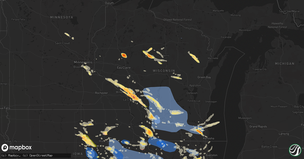
Hail Map in Wisconsin on July 28, 2023
Get this storm
July 28 map
$229
one time, instant access
Download today. No call, no setup
Keep the $229
Bought the map and want the full workflow? Apply the entire $229 to a subscription within 7 days. None of it is wasted.
Every map, not just this one
This buys you this map. Subscription and you get every map we run, in the markets you choose from a few cities to whole states to nationwide. Plus real-time alerts the moment a storm fires.
Contact data
Name, contact info, occupancy, even credit band for addresses in the footprint. You go from where it hit to who to call.
Become the source they trust
Unlimited branding weather history reports on demand. You already have the documented answer ready for the property owner, and you are the one who showed up with it.
Property data and RoofTrace estimates
Pull up any address you have got, its value and the exact code rules for that jurisdiction, straight from One Click Code. Then RoofTrace estimates the squares, pitch, and roof value, priced the way you price.
Storm reports in Wisconsin
Wisconsin
| Date | Description |
|---|---|
| 07/28/20236:55 PM CDT | Corrects location of previous hail report from ogema. A photo was received via a tv partner of a hailstone and a tape measure. The largest axis of the hail was 2 inches |
| 07/28/20236:55 PM CDT | A photo was received via a tv partner of a hailstone and a tape measure. The largest axis of the hail was 2 inches in diameter. |
| 07/28/20236:52 PM CDT | A local report indicates 2.75 inch wind near Bangor |
| 07/28/20236:47 PM CDT | Large branches down and several trees split or snapped off. |
| 07/28/20236:45 PM CDT | Verified by picture. |
| 07/28/20236:33 PM CDT | A local report indicates 2.75 inch wind near 3 E Holmen |
| 07/28/20236:33 PM CDT | A local report indicates 1.75 inch wind near Holmen |
| 07/28/20236:29 PM CDT | Corrects previous tstm wnd dmg report from 1 ne nelson. Powerlines blown down. Riverland energy cooperative reports 618 people without power. |
| 07/28/20236:25 PM CDT | A local report indicates 2.00 inch wind near 1 NE Medford |
| 07/28/20236:25 PM CDT | A local report indicates 2.50 inch wind near 1 W Medford |
| 07/28/20236:24 PM CDT | Golfball sizze hail at the fairgrounds. |
| 07/28/20236:24 PM CDT | Golfball size hail at the fairgrounds. |
| 07/28/20236:13 PM CDT | Quarter size hail has been falling for 10 minutes. |
| 07/28/20236:12 PM CDT | Spiky hail. Most hail stones were 2 in diameter but the largest was 3 in from spike to spike. |
| 07/28/20236:11 PM CDT | A local report indicates 1.75 inch wind near 3 NE Bloomer |
| 07/28/20236:08 PM CDT | Report from mping: quarter |
| 07/28/20233:56 PM CDT | Two public reports of estimated quarter to half dollar sized hail that fell on the south side of iola. Time estimated based on combination of reports and radar. |
| 07/28/202310:16 AM CDT | Report relayed via broadcast media. Multiple tree limbs around 10 inches in diameter down on vehicle. Estimated wind gusts around 60 mph. Time estimated based on radar. |
| 07/27/202311:00 PM CDT | A local report indicates 60 MPH wind near 1.5 N Muskego |
| 07/27/202310:55 PM CDT | 11in tree snapped on 69th st. |
| 07/27/202310:55 PM CDT | Awos station k57c east troy. |
| 07/27/202310:46 PM CDT | Split tree and another tree down. Time estimated from radar. |
| 07/27/202310:38 PM CDT | Trees down. Time estimated from radar. |
| 07/27/202310:36 PM CDT | Multiple trees down on hardscrabble rd. |
| 07/27/202310:35 PM CDT | Tree fell and took down power pole. Time estimated from radar. |
| 07/27/202310:30 PM CDT | Many 4-6 inch diameter branches down along grand ave s of hwy 60. Power pole damaged. Time estimated from radar. |
| 07/27/202310:30 PM CDT | Estimated 60-70 mph wind gust at wfo mkx. |
| 07/27/202310:25 PM CDT | 4 in tree branch snapped. |
| 07/27/202310:16 PM CDT | Corrects previous tstm wnd dmg report from fort atkinson. Report relayed via broadcast media. Multiple tree limbs around 10 inches in diameter down on vehicle. Estimate |
| 07/27/202310:05 PM CDT | Tree down on house. Time estimated from radar. |
| 07/27/20239:55 PM CDT | Tree down on woodland drive. Time estimated from radar. |
| 07/27/20239:55 PM CDT | Awos station keft monroe. |
| 07/27/20239:51 PM CDT | Estimated 8 inch diameter tree down on hwy 73 a half mile north of hwy d. |
| 07/27/20239:47 PM CDT | Asos station kmsn madison-dane county airport. |
| 07/27/20239:33 PM CDT | Corrects time in previous tstm wnd dmg report from sauk city. Report relayed via broadcast media. Large tree limb around 8 inches in diameter fell on house. Estimated w |
| 07/27/20239:32 PM CDT | Extensive damage reported to barns and trees. Nearby airport recorded 77mph wind gust. |
| 07/27/20239:30 PM CDT | Large tree down adjacent to a house on lake wisconsin. |
| 07/27/20239:25 PM CDT | Lone rock airport observation 67 kt/77 mph. |
| 07/27/20239:20 PM CDT | A local report indicates 1.75 inch wind near 2 ESE Sextonville |
| 07/27/20239:20 PM CDT | Several large trees down along the northern portions of lake wisconsin. Time estimated from radar. |
| 07/27/20239:16 PM CDT | A local report indicates 1.00 inch wind near 1 E Sextonville |
| 07/27/20239:00 PM CDT | Multiple trees down in the city. |
| 07/27/20238:46 PM CDT | A local report indicates 72 MPH wind near 1 E Wonewoc |
| 07/27/20238:41 PM CDT | Multiple trees down. |
| 07/27/20238:40 PM CDT | Reports from mping and through twitter. |
| 07/27/20238:40 PM CDT | Report relayed from social media. |
| 07/27/20238:39 PM CDT | Trees down and reports of power outages. |
| 07/27/20238:36 PM CDT | Picture via facebook. |
| 07/27/20238:35 PM CDT | Awos station kvok volk field. |
| 07/27/20238:33 PM CDT | Report relayed via broadcast media. Large tree limb around 8 inches in diameter fell on house. Estimated wind gust around 60 mph. Time estimated based on radar. |
| 07/27/20238:31 PM CDT | Trees down and power outages reported. |
| 07/27/20238:30 PM CDT | Multiple mature trees downed across hwy 21 between arkdale and necedah. |
| 07/27/20238:30 PM CDT | Mature pine trees downed. Power outages. |
| 07/27/20238:30 PM CDT | Mesonet station nehw3 necedah. |
| 07/27/20238:17 PM CDT | Half dollar sized hail relayed from broadcast media. |
| 07/27/20238:09 PM CDT | Trees down in warrens area. |
| 07/27/20238:04 PM CDT | Multiple reports of large trees downed or uprooted. |
| 07/27/20237:55 PM CDT | A local report indicates 1.50 inch wind near Bangor |
| 07/27/20237:53 PM CDT | Report from mping: 3-inch tree limbs broken; power poles broken. |
| 07/27/20237:52 PM CDT | Corrects previous hail report from bangor. |
| 07/27/20237:52 PM CDT | Social media photo with rulers for reference. |
| 07/27/20237:52 PM CDT | A local report indicates 2.75 inch wind near Bangor |
| 07/27/20237:51 PM CDT | Public report of around ping pong ball to possibly golf ball sized hail. Time estimated based on report and radar. |
| 07/27/20237:50 PM CDT | Law enforcement reports baseball size hail on neshonoc rd. |
| 07/27/20237:50 PM CDT | Report from mping: ping pong ball |
| 07/27/20237:50 PM CDT | Large tree down on house. |
| 07/27/20237:50 PM CDT | Photo from social media. |
| 07/27/20237:50 PM CDT | Report from mping: ping pong ball |
| 07/27/20237:47 PM CDT | Several trees blown down. One was blocking the road. |
| 07/27/20237:47 PM CDT | Corrects previous tstm wnd dmg report from west salem. Large branches down and several trees split or snapped off. |
| 07/27/20237:47 PM CDT | Several large trees and branches blown down near the high school parking lot. |
| 07/27/20237:46 PM CDT | A local report indicates 2.00 inch wind near 1 WSW West Salem |
| 07/27/20237:46 PM CDT | A local report indicates 2.50 inch wind near 1 W West Salem |
| 07/27/20237:46 PM CDT | Tennis ball hail broke windows. |
| 07/27/20237:46 PM CDT | Healthy tree split in half along with several large branches blown down in the area. |
| 07/27/20237:45 PM CDT | Verified by picture. |
| 07/27/20237:45 PM CDT | A local report indicates 1.00 inch wind near Darlington |
| 07/27/20237:45 PM CDT | Corrects previous hail report from 1 nw west salem. Verified by picture. |
| 07/27/20237:45 PM CDT | A local report indicates 1.00 inch wind near 4 E Holmen |
| 07/27/20237:41 PM CDT | A local report indicates 65 MPH wind near 1 NNW Onalaska |
| 07/27/20237:40 PM CDT | Several trees down. |
| 07/27/20237:39 PM CDT | Report from mping: 1-inch tree limbs broken; shingles blown off. |
| 07/27/20237:39 PM CDT | Powerlines blown down. Riverland energy cooperative reports 618 people without power. |
| 07/27/20237:35 PM CDT | Public report from social media of estimated quarter sized hail. |
| 07/27/20237:33 PM CDT | A local report indicates 2.75 inch wind near 3 E Holmen |
| 07/27/20237:33 PM CDT | A local report indicates 1.75 inch wind near Holmen |
| 07/27/20237:33 PM CDT | Corrects previous hail report from 3 e holmen. |
| 07/27/20237:33 PM CDT | Corrects previous hail report from holmen. |
| 07/27/20237:30 PM CDT | Mesonet station brvw3 i-94 eb. |
| 07/27/20237:30 PM CDT | A local report indicates 1.75 inch wind near 4 NE New Amsterdam |
| 07/27/20237:30 PM CDT | A local report indicates 2.00 inch wind near 4 NW Stevenstown |
| 07/27/20237:27 PM CDT | Via mping. |
| 07/27/20237:25 PM CDT | Picture via twitter. |
| 07/27/20237:25 PM CDT | Report from mping: quarter |
| 07/27/20237:21 PM CDT | A local report indicates 1.75 inch wind near Galesville |
| 07/27/20237:19 PM CDT | Measured and confirmed with photo. |
| 07/27/20237:12 PM CDT | Golf ball to hen egg size hail in platteville. |
All States Impacted by Hail Map on July 28, 2023
Cities Impacted by Hail Map on July 28, 2023
- Homestead, FL
- Miami, FL
- Jeffersonville, KY
- Mount Sterling, KY
- Augusta, KY
- Brooksville, KY
- Morehead, KY
- Van Buren, IN
- Marion, IN
- Sharpsburg, KY
- Owingsville, KY
- Bloomingburg, OH
- Marathon, WI
- Jeffersonville, OH
- West Liberty, KY
- Georgetown, OH
- Maysville, KY
- Dover, KY
- Sugar Grove, OH
- Mount Orab, OH
- La Fontaine, IN
- Kokomo, IN
- Ewing, KY
- Flemingsburg, KY
- Hillsboro, KY
- Wallingford, KY
- Hamersville, OH
- Bethel, OH
- Germantown, KY
- Midland, OH
- Blanchester, OH
- Sidney, OH
- Pemberton, OH
- Port Jefferson, OH
- Waynesville, OH
- Oregonia, OH
- Morrow, OH
- Wilmington, OH
- Clarksville, OH
- Cory, IN
- Jackson Center, OH
- Lewistown, OH
- Quincy, OH
- London, OH
- Mount Sterling, OH
- South Solon, OH
- Washington Court House, OH
- Salt Lick, KY
- Goshen, OH
- Loveland, OH
- Cincinnati, OH
- Williamsburg, OH
- Fayetteville, OH
- Batavia, OH
- Gadsden, AL
- Foster, KY
- Rapid City, SD
- Cheyenne, WY
- Fe Warren Afb, WY
- Carr, CO
- Nunn, CO
- Superior, NE
- Nelson, NE
- Hardy, NE
- Ault, CO
- Ruskin, NE
- Saint Paul, MN
- Republic, KS
- Mankato, KS
- Webber, KS
- Sterling, VA
- Ashburn, VA
- Poolesville, MD
- Belleville, KS
- Courtland, KS
- Nickerson, NE
- Hooper, NE
- Fremont, NE
- Arlington, NE
- Hampton, MN
- Hastings, MN
- Valley, NE
- Scandia, KS
- Chapman, NE
- Grand Island, NE
- Phillips, NE
- Aurora, NE
- Bennington, NE
- Elkhorn, NE
- Alden, IA
- Dows, IA
- Galt, IA
- Omaha, NE
- New Auburn, WI
- Bloomer, WI
- Cannon Falls, MN
- Boys Town, NE
- Marquette, NE
- Giltner, NE
- Sutton, NE
- Harvard, NE
- Saronville, NE
- Beloit, KS
- Jewell, KS
- Belgrade, MT
- Bozeman, MT
- Wilsall, MT
- White Sulphur Springs, MT
- Boulder, CO
- Longmont, CO
- Lagrange, WY
- Iowa Falls, IA
- Geneva, NE
- Ong, NE
- Edgar, NE
- Shickley, NE
- Geneva, IA
- Hampton, IA
- Bradford, IA
- Ackley, IA
- Aplington, IA
- Wellsburg, IA
- Holland, IA
- Parkersburg, IA
- Steamboat Rock, IA
- Grundy Center, IA
- Northport, AL
- Sandy Hook, KY
- Butte, MT
- Selma, AL
- Waverly, WV
- Williamstown, WV
- Parkersburg, WV
- Woodland Park, CO
- Ripley, WV
- Hamden, OH
- Burns, WY
- Medford, WI
- Concord, PA
- Doylesburg, PA
- Southside, WV
- Leon, WV
- Haddam, KS
- Little River, AL
- Elbert, CO
- Gay, WV
- Foreston, MN
- Milaca, MN
- Scandinavia, WI
- Iola, WI
- Amherst Junction, WI
- Prescott, AZ
- Foley, MN
- Pierz, MN
- Rice, MN
- Royalton, MN
- Waynesboro, MS
- Winchester, VA
- Clear Brook, VA
- Tuscaloosa, AL
- Duncanville, AL
- Greenwood, WI
- Loyal, WI
- Vermillion, MN
- Cleveland, GA
- Thomasville, AL
- Mapleton Depot, PA
- Seligman, AZ
- Ogdensburg, WI
- Nelsonville, WI
- Winfield, AL
- Wirtz, VA
- Boones Mill, VA
- Stevens Point, WI
- Custer, WI
- Manawa, WI
- Jamestown, KS
- Norway, KS
- Sweet Water, AL
- Elkfork, KY
- Glen Elder, KS
- Camden, AL
- Pine Apple, AL
- Little Hocking, OH
- Coolville, OH
- Cutler, OH
- Quitman, MS
- Adamsville, AL
- Hurricane, WV
- Scott Depot, WV
- Bunker Hill, WV
- Kearneysville, WV
- Inwood, WV
- Hillsdale, WY
- Sautee Nacoochee, GA
- Ferrum, VA
- Henry, VA
- Flat Rock, MI
- Kiowa, CO
- Henderson, NE
- Martha, KY
- Jackson, AL
- Saint Paul Park, MN
- Minneapolis, MN
- Burnsville, MN
- Farmington, MN
- Cottage Grove, MN
- Inver Grove Heights, MN
- Rosemount, MN
- New Straitsville, OH
- Junction City, OH
- Logan, OH
- Alderson, WV
- Summersville, WV
- Great Falls, VA
- Potomac, MD
- Germantown, MD
- Leesburg, VA
- Herndon, VA
- Isonville, KY
- Cairo, WV
- Cottondale, AL
- Biglerville, PA
- Gettysburg, PA
- Aspers, PA
- Campton, KY
- Beattyville, KY
- Big Springs, WV
- Big Bend, WV
- Purlear, NC
- West Jefferson, NC
- Millers Creek, NC
- Sunburg, MN
- Murray City, OH
- Glouster, OH
- Milton, WV
- Ona, WV
- Vienna, WV
- Marietta, OH
- Belpre, OH
- Memphis, MI
- Allenton, MI
- Winslow, NE
- Shippensburg, PA
- Waynesboro, PA
- Chambersburg, PA
- Fayetteville, PA
- Jachin, AL
- Ward, AL
- Keaton, KY
- Flatgap, KY
- Rockhill Furnace, PA
- Shirleysburg, PA
- Orbisonia, PA
- Shenandoah Junction, WV
- Shepherdstown, WV
- Harpers Ferry, WV
- Petroleum, WV
- Agenda, KS
- Gainesville, GA
- Murrayville, GA
- Malta, OH
- Saint Marys, WV
- Newport, OH
- Oak, NE
- Williamsburg, PA
- Dawsonville, GA
- Cotopaxi, CO
- Jackson, KY
- Pine Ridge, KY
- Rogers, KY
- Ranson, WV
- Charles Town, WV
- Washington, VA
- Bentonville, VA
- Ponderosa, NM
- Attalla, AL
- Fleming, OH
- Waterford, OH
- White Post, VA
- Boyce, VA
- Hayden, AL
- Cleveland, AL
- Whitehall, MT
- Central City, CO
- Black Hawk, CO
- Northfork, WV
- Switchback, WV
- Elkhorn, WV
- Glen Fork, WV
- Ravencliff, WV
- Harrisville, WV
- Berea, WV
- Auburn, WV
- Pounding Mill, VA
- Nederland, CO
- Mount Nebo, WV
- Tryon, NC
- Easley, SC
- Pickens, SC
- Vincent, OH
- Burr Oak, KS
- Concordia, KS
- Dickerson, MD
- Barnesville, MD
- Ijamsville, MD
- Damascus, MD
- Clarksburg, MD
- Mount Airy, MD
- Monrovia, MD
- Beallsville, MD
- Boyds, MD
- Wellston, OH
- Stockport, OH
- Helen, GA
- Golden, CO
- Rollinsville, CO
- Clanton, AL
- Jemison, AL
- New Milton, WV
- Troy, WV
- Coxs Mills, WV
- Jefferson, NC
- Woodville, VA
- Castleton, VA
- Clermont, GA
- Ames, NE
- New Baltimore, MI
- Macomb, MI
- McIntosh, AL
- Tibbie, AL
- Gainestown, AL
- Hico, WV
- Newland, NC
- Pennock, MN
- Murdock, MN
- Amherst, WI
- Oak Park, MN
- Waverly, IA
- Tripoli, IA
- Readlyn, IA
- Denver, IA
- Fennimore, WI
- Stitzer, WI
- Stetsonville, WI
- Athens, WI
- Livingston, WI
- Platteville, WI
- Belmont, WI
- Rewey, WI
- Mineral Point, WI
- Strang, NE
- Bruning, NE
- Carleton, NE
- Davenport, NE
- Simpson, KS
- Glasco, KS
- Barnard, KS
- Lincoln, NE
- Darlington, WI
- Roca, NE
- Arcadia, WI
- Cochrane, WI
- Fountain City, WI
- Bennet, NE
- Panama, NE
- Hickman, NE
- Douglas, NE
- Adams, NE
- Palmyra, NE
- Dodge, WI
- Trempealeau, WI
- Galesville, WI
- Ettrick, WI
- Lincoln, KS
- Holmen, WI
- Onalaska, WI
- Warrenville, IL
- Naperville, IL
- West Salem, WI
- Wheaton, IL
- Mindoro, WI
- Winfield, IL
- Carol Stream, IL
- West Chicago, IL
- Hazel Green, WI
- Dubuque, IA
- Gladbrook, IA
- Reinbeck, IA
- La Crosse, WI
- Bangor, WI
- Morrison, IA
- Rockland, WI
- Cashton, WI
- Sparta, WI
- Glendale Heights, IL
- Glen Ellyn, IL
- Riley, KS
- Manhattan, KS
- Leonardville, KS
- Ogden, KS
- Junction City, KS
- Fort Riley, KS
- Saint George, KS
- Paradise, KS
- Natoma, KS
- Waldo, KS
- Mountain, WI
- Mukwonago, WI
- East Troy, WI
- Suring, WI
- Alburnett, IA
- Marion, IA
- Shellsburg, IA
- Hiawatha, IA
- Robins, IA
- Center Point, IA
- Palo, IA
- Cedar Rapids, IA
- Vinton, IA
- Urbana, IA
- Toddville, IA
- Walker, IA
- Coggon, IA
- Prairieburg, IA
- La Porte City, IA
- Independence, IA
- Monticello, IA
- Quasqueton, IA
- Anamosa, IA
- Fairfax, IA
- Atkins, IA
- Jesup, IA
- Rowley, IA
- Mount Auburn, IA
- Dunkerton, IA
- Fairbank, IA
- Ryan, IA
- Masonville, IA
- Brandon, IA
- Springville, IA
- Central City, IA
- Waterloo, IA
- Winthrop, IA
- Epworth, IA
- Delhi, IA
- Peosta, IA
- Worthington, IA
- Durango, IA
- Manchester, IA
- Dyersville, IA
- Cascade, IA
- Earlville, IA
- Langworthy, IA
- Farley, IA
- Hopkinton, IA
- Bernard, IA
- Delaware, IA
- Waterford, WI
- Zwingle, IA
- East Dubuque, IL
- La Motte, IA
- Gillett, WI
- Lena, WI
- Toledo, IA
- Tama, IA
- Oconto Falls, WI
- Burlington, WI
- Union, IA
- Conrad, IA
- Eldora, IA
- Whitten, IA
- Edgar, WI
- Clemons, IA
- Marshalltown, IA
- State Center, IA
- Albion, IA
- Liscomb, IA
- Beaman, IA
- New Providence, IA
- Haverhill, IA
- Laurel, IA
- Melbourne, IA
- Garwin, IA
- Ferguson, IA
- Gilman, IA
- Montour, IA
- Le Grand, IA
- Westby, WI
- La Farge, WI
- Hillsboro, WI
- Ontario, WI
- Osborne, KS
- Elroy, WI
- Mauston, WI
- Lyndon Station, WI
- Wamego, KS
- Tecumseh, NE
- Cook, NE
- Burr, NE
- Sterling, NE
- Tipton, KS
- La Valle, WI
- Reedsburg, WI
- Wakeeney, KS
- Bellevue, IA
- Onslow, IA
- Baldwin, IA
- Center Junction, IA
- Oxford Junction, IA
- Olin, IA
- Ely, IA
- Maquoketa, IA
- Martelle, IA
- Mount Vernon, IA
- Lisbon, IA
- Morley, IA
- Wyoming, IA
- Monmouth, IA
- Stanwood, IA
- Mechanicsville, IA
- Iowa City, IA
- Lost Nation, IA
- Clarence, IA
- North Liberty, IA
- Swisher, IA
- West Branch, IA
- Tipton, IA
- Solon, IA
- Grand Mound, IA
- Durant, IA
- New Liberty, IA
- Delmar, IA
- Lowden, IA
- West Liberty, IA
- Bennett, IA
- Dixon, IA
- Atalissa, IA
- Calamus, IA
- Moscow, IA
- Muscatine, IA
- Wheatland, IA
- Wilton, IA
- Stockton, IA
- Camp Douglas, WI
- Warrens, WI
- Tomah, WI
- Kendall, WI
- Hustler, WI
- New Lisbon, WI
- Necedah, WI
- Nekoosa, WI
- Adams, WI
- Arkdale, WI
- Friendship, WI
- Hancock, WI
- Coloma, WI
- Wilton, WI
- Wonewoc, WI
- North Freedom, WI
- Grand Marsh, WI
- Baraboo, WI
- Westfield, WI
- Rock Springs, WI
- Oxford, WI
- Wisconsin Dells, WI
- Redgranite, WI
- Wautoma, WI
- Endeavor, WI
- Montello, WI
- Briggsville, WI
- Bancroft, WI
- Neshkoro, WI
- Wild Rose, WI
- Plainfield, WI
- Almond, WI
- Pine River, WI
- Plain, WI
- Cazenovia, WI
- Packwaukee, WI
- Hillpoint, WI
- Loganville, WI
- Portage, WI
- Prairie Du Sac, WI
- Spring Green, WI
- Sauk City, WI
- Preston, IA
- Spragueville, IA
- Taylor Ridge, IL
- Andalusia, IL
- Welton, IA
- Moline, IL
- Davenport, IA
- Milan, IL
- De Witt, IA
- Blue Grass, IA
- Eldridge, IA
- Montpelier, IA
- Rock Island, IL
- Walcott, IA
- Buffalo, IA
- Coal Valley, IL
- Long Grove, IA
- Donahue, IA
- Pleasant Valley, IA
- Charlotte, IA
- Bryant, IA
- Low Moor, IA
- Goose Lake, IA
- Sabula, IA
- Camanche, IA
- Teeds Grove, IA
- Bettendorf, IA
- East Moline, IL
- Le Claire, IA
- Miles, IA
- McCausland, IA
- Princeton, IA
- Clinton, IA
- Gratiot, WI
- Elizabeth, IL
- Galena, IL
- Benton, WI
- Cuba City, WI
- Scales Mound, IL
- Hanover, IL
- Apple River, IL
- Shullsburg, WI
- Stockton, IL
- Warren, IL
- Lena, IL
- Nora, IL
- Kent, IL
- Winslow, IL
- Pearl City, IL
- South Wayne, WI
- Browntown, WI
- McConnell, IL
- Shannon, IL
- Freeport, IL
- Orangeville, IL
- Monroe, WI
- Davis, IL
- Dakota, IL
- Rock City, IL
- Cedarville, IL
- Baileyville, IL
- Ridott, IL
- Forreston, IL
- Mount Morris, IL
- Pecatonica, IL
- German Valley, IL
- Leaf River, IL
- Winnebago, IL
- Byron, IL
- Durand, IL
- Rockford, IL
- Dalton, WI
- Merrimac, WI
- Cambria, WI
- Pardeeville, WI
- Poynette, WI
- Wyocena, WI
- Rio, WI
- Lime Ridge, WI
- Lone Rock, WI
- Richland Center, WI
- Avoca, WI
- Mazomanie, WI
- Dodgeville, WI
- Arena, WI
- Lodi, WI
- Markesan, WI
- Randolph, WI
- Friesland, WI
- Fall River, WI
- Doylestown, WI
- Ridgeway, WI
- Waunakee, WI
- Dane, WI
- Deforest, WI
- Black Earth, WI
- Barneveld, WI
- Columbus, WI
- Cross Plains, WI
- Madison, WI
- Mount Horeb, WI
- Blue Mounds, WI
- Highland, WI
- Arlington, WI
- Middleton, WI
- Morrisonville, WI
- Verona, WI
- Carbon Cliff, IL
- Colona, IL
- Silvis, IL
- Orion, IL
- Cordova, IL
- Port Byron, IL
- Rapids City, IL
- Hampton, IL
- Osco, IL
- Fulton, IL
- Cambridge, IL
- Albany, IL
- Geneseo, IL
- Hillsdale, IL
- Erie, IL
- Thomson, IL
- Mount Carroll, IL
- Lyndon, IL
- Savanna, IL
- Rock Falls, IL
- Morrison, IL
- Prophetstown, IL
- Sterling, IL
- Chadwick, IL
- Atkinson, IL
- Tampico, IL
- Fenton, IL
- Dixon, IL
- Beaver Dam, WI
- Fox Lake, WI
- Kingston, WI
- Juneau, WI
- Linden, WI
- Holton, KS
- Netawaka, KS
- Wetmore, KS
- Whiting, KS
- Muscotah, KS
- Powhattan, KS
- Horton, KS
- Hiawatha, KS
- Everest, KS
- Fairview, KS
- Windsor, WI
- Hollandale, WI
- Sun Prairie, WI
- Marshall, WI
- Oregon, WI
- Belleville, WI
- New Glarus, WI
- Reeseville, WI
- Cottage Grove, WI
- Deerfield, WI
- Blanchardville, WI
- Mcfarland, WI
- Stoughton, WI
- Waterloo, WI
- Albany, WI
- Brooklyn, WI
- Lowell, WI
- Watertown, WI
- Evansville, WI
- Cambridge, WI
- Johnson Creek, WI
- Lake Mills, WI
- Sheffield, IL
- Deer Grove, IL
- Harmon, IL
- Annawan, IL
- Hooppole, IL
- Walnut, IL
- Mineral, IL
- Milledgeville, IL
- Tucson, AZ
- Albion, IN
- Ligonier, IN
- Cope, CO
- Joes, CO
- Akron, CO
- Yuma, CO
- Edgerton, WI
- Fort Atkinson, WI
- Jefferson, WI
- Marengo, IL
- Garden Prairie, IL
- Belvidere, IL
- Genoa, IL
- Huntley, IL
- Elgin, IL
- Algonquin, IL
- Hampshire, IL
- Gilberts, IL
- Lake In The Hills, IL
- Carpentersville, IL
- Union, IL
- Dundee, IL
- Oskaloosa, IA
- Eddyville, IA
- Bussey, IA
- Ottumwa, IA
- Chillicothe, IA
- Kirkville, IA
- Minooka, IL
- Morris, IL
- Shorewood, IL
- Channahon, IL
- Elwood, IL
- Joliet, IL
- Wilmington, IL
- Helenville, WI
- Whitewater, WI
- Elkhorn, WI
- Palmyra, WI
- Eagle, WI
- Sullivan, WI
- Dousman, WI
- Rochester, WI
- Kansasville, WI
- Union Grove, WI
- Franksville, WI
- Hales Corners, WI
- Waukesha, WI
- Muskego, WI
- New Berlin, WI
- Oconomowoc, WI
- North Prairie, WI
- Franklin, WI
- Big Bend, WI
- Knoxville, IA
- Tracy, IA
- Harvey, IA
- Agency, IA
- Quinter, KS
- Park, KS
- Gove, KS
- Oakley, KS
- Montpelier, IN
- Keystone, IN
- Hartford City, IN
- Kinsman, IL
- Verona, IL
- Seneca, IL
- Mazon, IL
- Dwight, IL
- Gardner, IL
- Ransom, IL
- Winona, KS
- Gillette, WY
- Weston, WY
- Moorcroft, WY
- Devils Tower, WY
- Hot Springs, SD
- Edgemont, SD
- Custer, SD
- Merrill, WI
- Lee, IL
- Tomahawk, WI
- Roberts, MT
- Red Lodge, MT
- Dekalb, IL
- Rolling Prairie, IN
- La Porte, IN
- Cherry Valley, IL
- Monroe Center, IL
- Harrison, NE
- Hixton, WI
- Taylor, WI
- Westminster, MD
- Fredericksburg, IA
- Sumner, IA
- Clutier, IA
- Cartersville, GA
- Hudson, IA
- Buckingham, IA
- Wilber, NE
- Hallam, NE
- Black River Falls, WI
- Sheffield, IA
- Kirkland, AZ
- Etna Green, IN
- Warsaw, IN
- Garrison, IA
- Dysart, IA
- Clarkston, GA
- Atlanta, GA
- Decatur, GA
- Scottdale, GA
- Stone Mountain, GA
- Tucker, GA
- Beverly Shores, IN
- Chesterton, IN
- Michigan City, IN
- Hubbard, IA
- Ogema, WI
- Westboro, WI
- Monkton, MD
- White Hall, MD
- Sparks Glencoe, MD
- Parkton, MD
- Alma, WI
- Cedar Falls, IA
- Syracuse, IN
- Randolph, KS
- Olsburg, KS
- Watkins, IA
- Blairstown, IA
- Holtwood, PA
- Airville, PA
- Madison, AL
- Downers Grove, IL
- Clarendon Hills, IL
- Westmont, IL
- Oak Brook, IL
- Prospect Heights, IL
- Arlington Heights, IL
- Palatine, IL
- Mount Prospect, IL
- Rolling Meadows, IL
- Kingsford Heights, IN
- Hamlet, IN
- Walkerton, IN
- Union Mills, IN
- Townsend, WI
- White Lake, WI
- Wanatah, IN
- Otter Lake, MI
- Columbiaville, MI
- Melrose, WI
- Ohiowa, NE
- Milligan, NE
- Crown King, AZ
- Osseo, WI
- Strum, WI
- Traer, IA
- Hawkeye, IA
- Rochester, IN
- Macy, IN
- Roscoe, MT
- Millersburg, IN
- Topeka, IN
- Rixeyville, VA
- Loves Park, IL
- Roselle, IL
- Waukegan, IL
- Zion, IL
- Martinsdale, MT
- Elburn, IL
- Meservey, IA
- Belmond, IA
- Goodell, IA
- Sherrill, IA
- Potosi, WI
- Dunlap, IA
- Moorhead, IA
- Woodbine, IA
- Monroeville, IN
- Hoagland, IN
- Saginaw, MI
- Berne, IN
- Saint Charles, IL
- Geneva, IL
- Wayne, IL
- Bartlett, IL
- Kirkland, IL
- Esmond, IL
- Lindenwood, IL
- Clay Center, KS
- North Webster, IN
- Cromwell, IN
- Kimmell, IN
- Larwill, IN
- Pierceton, IN
- Columbia City, IN
- Poplar Grove, IL
- Portsmouth, IA
- Wabash, IN
- Peru, IN
- New Hampton, IA
- Newton, IA
- Logan, IA
- Persia, IA
- Shelby, IA
- Janesville, IA
- Shell Rock, IA
- Drummond, MT
- Gold Creek, MT
- Helmville, MT
- Hazleton, IA
- Church Hill, TN
- Pima, AZ
- Vassar, MI
- Marion, WI
- Virginia, NE
- Beatrice, NE
- Blue Springs, NE
- Mount Lemmon, AZ
- Colfax, WI
- South Amana, IA
- Homestead, IA
- Mayville, MI
- Caro, MI
- Knox, IN
- Kewanna, IN
- Windsor Mill, MD
- Davey, NE
- Argos, IN
- Leesburg, IN
- Milford, IN
- West Union, IA
- Milwaukee, WI
- Saint Francis, WI
- Cudahy, WI
- Keystone, IA
- Pylesville, MD
- Street, MD
- New Park, PA
- Jarrettsville, MD
- Stewartstown, PA
- Frankenmuth, MI
- Culver, IN
- Grovertown, IN
- Clatonia, NE
- Hebron, NE
- Belvidere, NE
- Alexandria, NE
- Deer Trail, CO
- Van Horne, IA
- Rosholt, WI
- Hoffman Estates, IL
- Barrington, IL
- Victor, IA
- Brooklyn, IA
- Filley, NE
- Pickrell, NE
- Vail, AZ
- Boscobel, WI
- Harvard, IL
- Capron, IL
- Goshen, IN
- Jackson, MS
- Martell, NE
- Ladysmith, WI
- Libertyville, IL
- Gurnee, IL
- Lake Zurich, IL
- Vernon Hills, IL
- Mundelein, IL
- Amissville, VA
- Wood Dale, IL
- Itasca, IL
- Lombard, IL
- Bloomingdale, IL
- Medinah, IL
- Elk Grove Village, IL
- Addison, IL
- Tippecanoe, IN
- New Oxford, PA
- York Springs, PA
- Norwalk, WI
- Sykesville, MD
- Stockholm, WI
- Nelson, WI
- Wabasha, MN
- Reads Landing, MN
- Kellogg, MN
- Coon Valley, WI
- Pepin, WI
- Lake City, MN
- Clinton, WI
- South Beloit, IL
- Beloit, WI
- Withee, WI
- Rockford, IA
- Rockwell, IA
- Elberon, IA
- Belle Plaine, IA
- Vining, IA
- Chelsea, IA
- Marengo, IA
- Bourbon, IN
- Sabetha, KS
- Liberty, NE
- Lewiston, NE
- Burchard, NE
- Albin, WY
- Rhodes, IA
- Lookout, WV
- Bay City, MI
- Reese, MI
- Munger, MI
- Denver, IN
- South Elgin, IL
- Hanover Park, IL
- Rudd, IA
- Westmoreland, KS
- Bowdon, GA
- Graham, AL
- Rutherfordton, NC
- Columbus, NC
- Mill Spring, NC
- Grinnell, IA
- Malcom, IA
- Latimer, IA
- Coulter, IA
- Somerset, WI
- Hudson, WI
- Sylvan Grove, KS
- Hunter, KS
- Exeter, NE
- Woodbine, MD
- Gaithersburg, MD
- Reston, VA
- Wiggins, CO
- Oak Creek, WI
- Caledonia, WI
- Greendale, WI
- South Milwaukee, WI
- Alpharetta, GA
- Pine Bluffs, WY
- Mason City, IA
- Nappanee, IN
- Rockville, MD
- Firth, NE
- Randolph, MN
- Hanna, IN
- Corunna, IN
- Kendallville, IN
- Swaledale, IA
- Clear Lake, IA
- Mount Hope, WI
- Lancaster, WI
- Nora Springs, IA
- Twelve Mile, IN
- Clay Center, NE
- Grafton, NE
- Elrod, AL
- Middlebury, IN
- North Branch, MI
- Attica, MI
- Fostoria, MI
- Lapeer, MI
- Warren, IN
- Lineville, AL
- Hanover, PA
- Glenwood, WV
- Noxapater, MS
- Philadelphia, MS
- Skull Valley, AZ
- Monterey, IN
- Plymouth, IN
- Ora, IN
- North Judson, IN
- Benson, AZ
- Baltimore, MD
- Wausau, WI
- Brokaw, WI
- Axtell, KS
- New Hartford, IA
- New Richmond, WI
- Lucas, KS
- Hayden, AZ
- Kearny, AZ
- Woodstock, GA
- Brookfield, WI
- Orrtanna, PA
- East Berlin, PA
- Madison, VA
- Sperryville, VA
- Kellogg, IA
- Bolton, MS
- Dewar, IA
- Evansdale, IA
- Mayetta, KS
- Norway, IA
- Newhall, IA
- Elgin, IA
- Quarryville, PA
- Drumore, PA
- New Providence, PA
- Armstrong, IL
- New Windsor, MD
- Union Bridge, MD
- Brush, CO
- Bowersville, GA
- Akron, IN
- Kingston, IL
- Reisterstown, MD
- Upperco, MD
- Centerville, PA
- Titusville, PA
- Saint David, AZ
- Potomac, IL
- Rossville, IL
- Henning, IL
- Woodstock, IL
- Wonder Lake, IL
- Batavia, IL
- Deerfield, IL
- Northbrook, IL
- Highland Park, IL
- Sturtevant, WI
- Kenosha, WI
- Millington, MI
- Decorah, IA
- Cary, IL
- Wauconda, IL
- Lucerne, IN
- Dougherty, IA
- Marble Rock, IA
- Charles City, IA
- Torrington, WY
- Floyd, IA
- Wadley, AL
- Davis Junction, IL
- Dover, PA
- Thomasville, PA
- Fort Jennings, OH
- Cloverdale, OH
- Columbus Grove, OH
- Bailey, MS
- De Kalb, MS
- Landrum, SC
- Felton, PA
- Finksburg, MD
- Fallston, MD
- Fawn Grove, PA
- Phoenix, MD
- Hampstead, MD
- Emmett, KS
- Brogue, PA
- Red Lion, PA
- Jeffersonton, VA
- Warrenton, VA
- Cooksville, MD
- Triangle, VA
- Johnstown, CO
- Baxter, IA
- Alexander, IA
- Rowan, IA
- Clifton, KS
- Radcliffe, IA
- Decatur, IN
- Craigville, IN
- Lisle, IL
- Wasco, IL
- Edgewater, MD
- Luray, KS
- Rockton, IL
- Morrowville, KS
- Linn, KS
- Kingsville, MD
- White Marsh, MD
- Perry Hall, MD
- Delavan, WI
- Clermont, IA
- Burlington, IL
- Maple Park, IL
- Sycamore, IL
- Crystal Lake, IL
- Muscoda, WI
- Cortland, NE
- Oxford, IA
- Gordo, AL
- New Paris, IN
- Winamac, IN
- Shabbona, IL
- Hinckley, IL
- Clare, IL
- Malta, IL
- Waterman, IL
- Rochelle, IL
- Mentone, IN
- Smithwick, SD
- Oelrichs, SD
- Sundance, WY
- Walton, IN
- Miami, IN
- Bunker Hill, IN
- Galveston, IN
- Grissom Arb, IN
- Converse, IN
- Amboy, IN
- Swayzee, IN
- Greentown, IN
- Pine Ridge, SD
- Butler, IN
- Leo, IN
- Auburn, IN
- Grabill, IN
- Saint Joe, IN
- Spencerville, IN
- Garrett, IN
- Hicksville, OH
- Sherwood, OH
- Edgerton, OH
- Mark Center, OH
- Ney, OH
- Stryker, OH
- Defiance, OH
- Evansport, OH
- Bryan, OH
- Napoleon, OH
- Wauseon, OH
- Liberty Center, OH
- Ridgeville Corners, OH
- Archbold, OH
- Harlan, IN
- Cecil, OH
- Antwerp, OH
- Holgate, OH
- Huntertown, IN
- Malinta, OH
- McClure, OH
- Weston, OH
- Grelton, OH
- Grand Rapids, OH
- Portland, IN
- Pennville, IN
- Bryant, IN
- Monroe, IN
- Geneva, IN
- Bluffton, IN
- Willshire, OH
- Spencerville, OH
- Mendon, OH
- Ohio City, OH
- Coldwater, OH
- Fort Recovery, OH
- Celina, OH
- Rockford, OH
- Saint Marys, OH
- Salamonia, IN
- Ridgeville, IN
- New Bremen, OH
- Montezuma, OH
- Saint Henry, OH
- Maria Stein, OH
- Chickasaw, OH
- Minster, OH
- New Weston, OH
- Burkettsville, OH
- Union City, OH
- Rossburg, OH
- Union City, IN
- Petroleum, IN
- Redkey, IN
- Dunkirk, IN
- Dunning, NE
- Arnold, NE
- Stapleton, NE
- Purdum, NE
- Thedford, NE
- Halsey, NE
- Brewster, NE
- Taylor, NE
- Anselmo, NE
- Burwell, NE
- Sargent, NE
- Merna, NE
- Comstock, NE
- Broken Bow, NE
- Elyria, NE
- Ord, NE
- Greeley, NE
- North Loup, NE
- Scotia, NE
- Ashton, NE
- Miller, NE
- Lexington, NE
- Oconto, NE
- Westerville, NE
- Callaway, NE
- Litchfield, NE
- Ansley, NE
- Cozad, NE
- Overton, NE
- Sumner, NE
- Mason City, NE
- Eddyville, NE
- Brady, NE
- Arcadia, NE
- Loup City, NE
- Gothenburg, NE
- Seneca, NE
- Sherrard, IL
- Millersburg, OH
- Chadron, NE
- Hay Springs, NE
- Coshocton, OH
- Kimbolton, OH
- Newcomerstown, OH
- Parnell, IA
- North English, IA
- Ludlow, IL
- Rankin, IL
- Elliott, IL
- Melvin, IL
- Gibson City, IL
- Loda, IL
- Paxton, IL
- Chariton, IA
- Stonington, IL
- Taylorville, IL
- Glendo, WY
- Jay Em, WY
- Hill City, KS
- Denver, MO
- Worth, MO
- Fremont, IA
- Dewey, IL
- Rantoul, IL
- Johnstown, NE
- Danville, IL
- Valentine, NE
- Avilla, IN
- South Haven, MI
- Winnett, MT
- Macomb, IL
- Gotham, WI
- Pioneer, OH
- Montpelier, OH
- Edon, OH
- Upland, IN
- Baroda, MI
- Alvordton, OH
- Waterloo, IN
- Hamilton, IN
- Camden, MI
- Elkhart, IN
- Albia, IA
- Lovilia, IA
- West Unity, OH
- Morenci, MI
- Fayette, OH
- Lovington, IL
- Elm Grove, WI
- Thorntown, IN
- Park Ridge, IL
- Des Plaines, IL
- Streamwood, IL
- Bridger, MT
- Cortland, IL
- Somonauk, IL
- Steward, IL
- Conesville, OH
- Dresden, OH
- Bird City, KS
- Kouts, IN
- Valparaiso, IN
- Bingham, NE
- Ashby, NE
- Ellsworth, NE
- Lemont, IL
- Willowbrook, IL
- Ashland, OH
- Perrysville, OH
- Schaumburg, IL
- Fithian, IL
- Ogden, IL
- Rexford, KS
- Colby, KS
- Bassett, NE
- Canton, IL
- Laotto, IN
- Herndon, KS
- West Lafayette, IN
- Lafayette, IN
- Martin, SD
- Wanblee, SD
- Collyer, KS
- Blue River, WI
- Norwich, OH
- Zanesville, OH
- Adamsville, OH
- Fostoria, OH
- Bensenville, IL
- Monument, KS
- Yarmouth, IA
- Morning Sun, IA
- Liberty Center, IN
- Dalton City, IL
- Argenta, IL
- Leighton, IA
- Cedar, IA
- South Bend, IN
- North Liberty, IN
- Lusk, WY
- Lakeville, IN
- Shelby, OH
- Crestline, OH
- Galion, OH
- Mansfield, OH
- Plano, IA
- Mystic, IA
- Huntington, IN
- Williamsburg, IA
- La Place, IL
- Hammond, IL
- Earl Park, IN
- Farmersburg, IA
- Garnavillo, IA
- Lagro, IN
- Pella, IA
- Brook, IN
- Kentland, IN
- Goodland, IN
- Stephenson, VA
- Sand Creek, MI
- Jasper, MI
- Amboy, IL
- Franklin Grove, IL
- West Brooklyn, IL
- Westpoint, IN
- Roann, IN
- Waldron, MI
- Sugarcreek, OH
- Loudonville, OH
- Lucas, OH
- New Carlisle, IN
- Galien, MI
- Hudson, MI
- New Richmond, IN
- Romney, IN
- Denton, KS
- Monroe, IA
- Otley, IA
- Urbana, IL
- Oakwood, IL
- Muncie, IL
- Saint Joseph, IL
- Swanton, OH
- Delta, OH
- Colfax, IN
- Darlington, IN
- Willard, OH
- Eau Claire, MI
- San Jose, IL
- Emden, IL
- Linkwood, MD
- Cambridge, MD
- Tuscola, IL
- Denton, MD
- Harrington, DE
- Montgomery, MI
- Bainbridge, IN
- Roachdale, IN
- Downing, MO
- Lancaster, MO
- Gordon, NE
- Westville, IN
- Mayer, AZ
- Manteno, IL
- Mishawaka, IN
- Fort Wayne, IN
- Schererville, IN
- Dyer, IN
- Saint John, IN
- New Virginia, IA
- New Buffalo, MI
- Mill Creek, IN
- Rome City, IN
- Atwood, IN
- Winona Lake, IN
- Churubusco, IN
- Burket, IN
- Wawaka, IN
- Claypool, IN
- Ainsworth, IA
- Crawfordsville, IA
- Washington, IA
- Mchenry, IL
- Sheldon, IL
- Bloomfield, IA
- Cantril, IA
- Milton, IA
- Pulaski, IA
- Wellman, IA
- South English, IA
- Ladora, IA
- Willow Springs, IL
- Bismarck, IL
- State Line, IN
- Alvin, IL
- West Lebanon, IN
- Covington, IN
- Williamsport, IN
- Vona, CO
- Crawfordsville, IN
- Ladoga, IN
- Whitehouse, OH
- Maumee, OH
- Waterville, OH
- Monclova, OH
- Stockton, MO
- Humansville, MO
- Berrien Springs, MI
- Saint Joseph, MI
- Wakarusa, IN
- Bremen, IN
- Saint Francis, KS
- Brookfield, IL
- Riverside, IL
- Moravia, IA
- Palco, KS
- Lanark, IL
- Luray, MO
- Keosauqua, IA
- Mount Sterling, IA
- Arbela, MO
- Hamilton, IA
- Greencastle, IN
- Brazil, IN
- Cornville, AZ
- Godfrey, IL
- Sciota, IL
- Blandinsville, IL
- Ellis, KS
- Deep River, IA
- Millersburg, IA
- Keota, IA
- Guernsey, IA
- Church Creek, MD
- Collison, IL
- Poneto, IN
- Holmesville, OH
- Sugar Grove, IL
- Montgomery, IL
- Plainfield, IL
- Bolingbrook, IL
- Oswego, IL
- Romeoville, IL
- Bristol, IL
- Aurora, IL
- Oral, SD
- Sussex, WI
- Pewaukee, WI
- Wheeling, IL
- Ainsworth, NE
- Prairie City, IA
- Runnells, IA
- Compton, IL
- La Harpe, IL
- Dallas City, IL
- Winkelman, AZ
- Cincinnati, IA
- Exline, IA
- Centerville, IA
- Lebanon, IN
- Cissna Park, IL
- Gas City, IN
- Hartsburg, IL
- Healy, KS
- Viola, WI
- Amelia, NE
- Wood Lake, NE
- Lynnville, IA
- Killduff, IA
- Sully, IA
- Paw Paw, MI
- Lawton, MI
- Mediapolis, IA
- East New Market, MD
- Rhodesdale, MD
- Vienna, MD
- Truro, IA
- Hazard, NE
- Amherst, NE
- Pleasanton, NE
- Wolbach, NE
- Elba, NE
- Ravenna, NE
- Farwell, NE
- Rockville, NE
- Saint Paul, NE
- Riverdale, NE
- Odessa, NE
- Elm Creek, NE
- Kearney, NE
- Gibbon, NE
- Dannebrog, NE
- Boelus, NE
- Cairo, NE
- Wilcox, NE
- Funk, NE
- Holdrege, NE
- Loomis, NE
- Shelton, NE
- Axtell, NE
- Bertrand, NE
- Minden, NE
- Alma, NE
- Saint Libory, NE
- Heartwell, NE
- Palmer, NE
- Wood River, NE
- Alda, NE
- Doniphan, NE
- Hildreth, NE
- Kenesaw, NE
- Fullerton, NE
- Archer, NE
- Clarks, NE
- Central City, NE
- Juniata, NE
- Holstein, NE
- Republican City, NE
- Hastings, NE
- Trumbull, NE
- Campbell, NE
- Upland, NE
- Ayr, NE
- Glenvil, NE
- Bladen, NE
- Roseland, NE
- Naponee, NE
- Franklin, NE
- Riverton, NE
- Bloomington, NE
- Red Cloud, NE
- Inavale, NE
- Blue Hill, NE
- Orleans, NE
- Atlanta, NE
- Inland, NE
- Hampton, NE
- Bradshaw, NE
- Stromsburg, NE
- Guide Rock, NE
- Hordville, NE
- Lawrence, NE
- Polk, NE
- Fairfield, NE
- Deweese, NE
- Benedict, NE
- York, NE
- Tiffin, OH
- Rib Lake, WI
- Bluford, IL
- Opdyke, IL
- Hinsdale, IL
- Maxwell, NE
- Clay City, IN
- Centerpoint, IN
- Demorest, GA
- Bucyrus, OH
- Alton, IL
- Bethalto, IL
- Whitehall, WI
- Jim Falls, WI
- Cornell, WI
- Oakdale, IL
- Darien, IL
- Woodridge, IL
- Sandusky, OH
- Donovan, IL
- Exeland, WI
- Waucoma, IA
- Granton, WI
- Neillsville, WI
- Wharton, OH
- Fairchild, WI
- Augusta, WI
- Crete, IL
- New Philadelphia, OH
- Stone Creek, OH
- Baltic, OH
- Brookville, IN
- Bland, MO
- Chippewa Falls, WI
- Addieville, IL
- Okawville, IL
- Nashville, IL
- Moorefield, NE
- Mason City, IL
- Eustis, NE
- Big Rock, IL
- Sandwich, IL
- Paw Paw, IL
- Avon Lake, OH
- Avon, OH
- Lyons, OH
- Prentice, WI
- Tiro, OH
- New Washington, OH
- Oldenburg, IN
- Batesville, IN
- Shelbyville, IL
- Beecher City, IL
- Lakewood, IL
- Cowden, IL
- Stewardson, IL
- Mode, IL
- Grainfield, KS
- Camargo, IL
- Villa Grove, IL
- Mondovi, WI
- Upper Sandusky, OH
- Woodman, WI
- Elmore, OH
- Fairmont, NE
- Independence, WI
- Eleva, WI
- Oberlin, KS
- Kansas, OH
- Maplewood, OH
- Hines, IL
- La Grange Park, IL
- Broadview, IL
- Maywood, IL
- Westchester, IL
- Toledo, OH
- Eau Claire, WI
- Hebron, IN
- Crown Point, IN
- Republic, OH
- Baldwin, IL
- Ossian, IA
- Sabina, OH
- Jamestown, OH
- Decatur, IL
- Blair, WI
- Brighton, IL
- Ogallah, KS
- Villa Park, IL
- Tower Hill, IL
- Oconee, IL
- Lebanon, IL
- O'Fallon, IL
- Mount Vernon, IL
- Norwalk, OH
- Cambridge, NE
- Russellville, IN
- Irvine, KY
- Crookston, NE
- Bellevue, OH
- Monroeville, OH
- Bellville, OH
- McGregor, IA
- Atwood, IL
- De Graff, OH
- Trenton, IL
- Metamora, IN
- Couderay, WI
- Radisson, WI
- Shipshewana, IN
- Montfort, WI
- Attica, OH
- Sumner, MI
- Momence, IL
- Kankakee, IL
- Bradley, IL
- Lockport, IL
- Crest Hill, IL
- Manhattan, IL
- New Lenox, IL
- Frankfort, IL
- Monee, IL
- Peotone, IL
- Beecher, IL
- Grant Park, IL
- Bourbonnais, IL
- Coal City, IL
- Pembroke Township, IL
- Saint Anne, IL
- Aroma Park, IL
- Bonfield, IL
- South Holland, IL
- Dolton, IL
- Thornton, IL
- Riverdale, IL
- Hammond, IN
- Harvey, IL
- Whiting, IN
- Calumet City, IL
- Chicago, IL
- East Chicago, IN
- Munster, IN
- Lansing, IL
- Gary, IN
- Highland, IN
- Griffith, IN
- Merrillville, IN
- Hobart, IN
- Chicago Heights, IL
- Glenwood, IL
- Blue Island, IL
- Lake Station, IN
- Newark, IL
- Yorkville, IL
- Millbrook, IL
- Plano, IL
- Sheridan, IL
- Millington, IL
- Leland, IL
- Auburn, IA
- Baring, MO
- Ursa, IL
- Mendon, IL
- Pawnee, IL
- Edinburg, IL
- Argonne, WI


