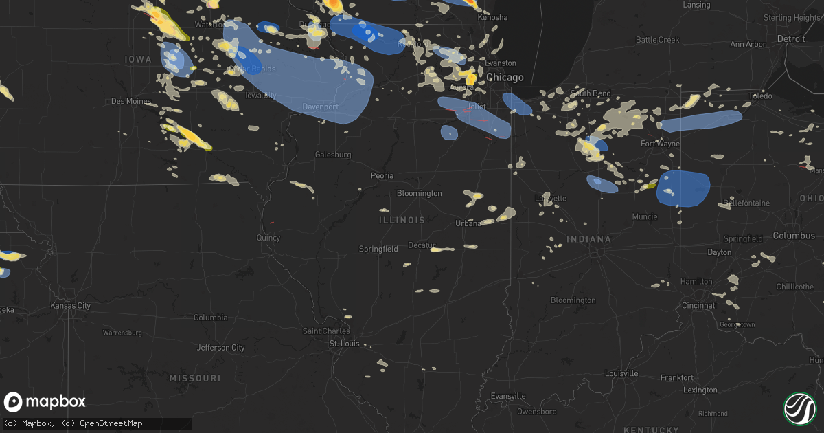
Hail Map in Illinois on July 28, 2023
Get this storm
July 28 map
$229
one time, instant access
Download today. No call, no setup
Keep the $229
Bought the map and want the full workflow? Apply the entire $229 to a subscription within 7 days. None of it is wasted.
Every map, not just this one
This buys you this map. Subscription and you get every map we run, in the markets you choose from a few cities to whole states to nationwide. Plus real-time alerts the moment a storm fires.
Contact data
Name, contact info, occupancy, even credit band for addresses in the footprint. You go from where it hit to who to call.
Become the source they trust
Unlimited branding weather history reports on demand. You already have the documented answer ready for the property owner, and you are the one who showed up with it.
Property data and RoofTrace estimates
Pull up any address you have got, its value and the exact code rules for that jurisdiction, straight from One Click Code. Then RoofTrace estimates the squares, pitch, and roof value, priced the way you price.
Storm reports in Illinois
Illinois
| Date | Description |
|---|---|
| 07/28/20239:14 AM CDT | Several 2 inch diameter tree limbs down. Time estimated using radar. |
| 07/27/202311:35 PM CDT | Multiple reports of downed trees and tree limbs in the momence area. Time estimated from radar. |
| 07/27/202311:34 PM CDT | Multiple trees uprooted. Time estimated from radar. |
| 07/27/202311:33 PM CDT | Large tree limb downed onto a car in thornton. Time estimated from radar. |
| 07/27/202311:33 PM CDT | Significant damage to a residence on the south side of momence. Possible tornado damage. |
| 07/27/202311:23 PM CDT | Trees and power lines downed in bradley. Time estimated from radar. |
| 07/27/202311:22 PM CDT | Tree branch downed onto il-115 southwest of kankakee. Time estimated by radar. |
| 07/27/202311:22 PM CDT | Possible radar tds just south of peotone. |
| 07/27/202311:22 PM CDT | Corrects previous tstm wnd dmg report from 2 wsw kankakee. Tree downed onto il-115 southwest of kankakee. Time estimated by radar. |
| 07/27/202311:16 PM CDT | Power pole downed in lockport. Time estimated from radar. |
| 07/27/202311:16 PM CDT | Roof partially torn off frankfort fire station. Possible tornado damage. |
| 07/27/202311:15 PM CDT | Several reports of downed trees and branches in the tall grass subdivision. Time estimated from radar. |
| 07/27/202311:15 PM CDT | Power pole snapped. Time estimated from radar. |
| 07/27/202311:14 PM CDT | Peak gust measured by mesonet station up781 elwod1. |
| 07/27/202311:05 PM CDT | Several trees approximately 12 inches in diameter uprooted near the intersection of main st. And cook st. In braidwood. |
| 07/27/202311:00 PM CDT | Measured on personal weather station. |
| 07/27/202311:00 PM CDT | Estimated 60-70mph gust. |
| 07/27/202310:57 PM CDT | Multiple reports of large trees downed in channahon. Time estimated from radar. |
| 07/27/202310:57 PM CDT | Multiple reports of tree damage in shorewood. Time estimated from radar. |
| 07/27/202310:55 PM CDT | Peak gust measured by mesonet station dvi02735 3 wnw mazon. |
| 07/27/202310:54 PM CDT | Private weather station kilveron5 recorded 71mph gust. |
| 07/27/202310:53 PM CDT | Roof partially torn off church in minooka. Possible tornado damage. |
| 07/27/202310:52 PM CDT | Utility pole downed. Time estimated from radar. |
| 07/27/202310:49 PM CDT | Multiple reports of large trees downed in yorkville. Time estimated from radar. |
| 07/27/202310:47 PM CDT | Many large branches up to 8 inches in diameter across central and eastern naperville. |
| 07/27/202310:45 PM CDT | Multiple trees down and several large branches down around plattville. Pictures via social media. |
| 07/27/202310:44 PM CDT | Large tree snapped at the base along with several large branches. Time estimated from radar. |
| 07/27/202310:40 PM CDT | Large tree branches down on house. Picture via social media. |
| 07/27/202310:40 PM CDT | Pictures received of a barn with part of its roof blown off... Damage to barn door... And a small storage tank knocked over. Time estimated from radar. |
| 07/27/202310:40 PM CDT | 8 inch tree snapped near sheriff office... 2-3 inch tree limbs down. Time estimated from radar. |
| 07/27/202310:37 PM CDT | 15-20 inch diameter tree snapped in millbrook. Time estimated by radar. |
| 07/27/202310:36 PM CDT | Trees downed onto crimmins rd. Time estimated from radar. |
| 07/27/202310:35 PM CDT | Trained spotter estimated wind gusts up to 60 mph in mount prospect. |
| 07/27/202310:34 PM CDT | Peak gust measured on personal weather station kilsandw47. |
| 07/27/202310:33 PM CDT | Relayed via spotter network. |
| 07/27/202310:30 PM CDT | A local report indicates 1.00 inch wind near 1 S Sycamore |
| 07/27/202310:25 PM CDT | Trained spotter estimated 70 mph wind gusts just west of somonauk. |
| 07/27/202310:16 PM CDT | Peak gust measured on personal weather station kilgenev45. |
| 07/27/202310:07 PM CDT | Multiple downed tree branches and power lines in mendota. Time estimated by radar. |
| 07/27/202310:06 PM CDT | Photo shared via social media shows numerous large branches downed on il-251 north of mendota. Time estimated by radar. |
| 07/27/202310:04 PM CDT | Large limbs down. |
| 07/27/202310:04 PM CDT | Picture of tree down on home relayed via social media. Time estimated from radar. |
| 07/27/202310:00 PM CDT | Trees and wires downed in dixon. Time estimated from radar. |
| 07/27/20239:52 PM CDT | Several large tree branches and limbs downed in polo. Time estimated from radar. |
| 07/27/20239:50 PM CDT | Tree on a house and a propane tank just s/se of polo at sterling rd and route 26. |
| 07/27/20239:50 PM CDT | Personal weather station measured a 59mph gust. |
| 07/27/20239:50 PM CDT | Corrects previous tstm wnd dmg report from 5 e harmon. Tree downed onto a house and a propane tank south of polo at sterling rd and route 26. |
| 07/27/20239:45 PM CDT | Multiple power lines and tree limbs down between geneseo and annawan. |
| 07/27/20239:33 PM CDT | 8 to 12 inch diameter tree limb down on neighbors property. Time of the event was estimated using radar. |
| 07/27/20239:26 PM CDT | Report from mping: 1-inch tree limbs broken; shingles blown off. |
| 07/27/20239:25 PM CDT | Tree down on coyne center rd near trailer park... Time estimated from radar. |
| 07/27/20239:23 PM CDT | Scattering of trees downed. |
| 07/27/20239:22 PM CDT | Time estimated from radar. |
| 07/27/20239:19 PM CDT | Two... 2 inch diameter tree limbs down. Time of the event estimated using radar. |
| 07/27/20239:14 PM CDT | Report from mping: 1-inch tree limbs broken; shingles blown off. |
| 07/27/20239:10 PM CDT | Reports of several trees down and damage to siding of a home in the candlewick lake subdivision. Time estimated from radar. |
| 07/27/20239:10 PM CDT | Measured at poplar grove airport. |
| 07/27/20239:00 PM CDT | Several trees down within the county... With trees down over wires in galena. Time estimated from radar. |
| 07/27/20238:56 PM CDT | Several 5 inch diameter tree limbs down near intersection of harlem and empire... Time estimated from radar. |
| 07/27/20238:51 PM CDT | A local report indicates 60 MPH wind near Freeport |
| 07/27/20238:51 PM CDT | Report from mping: trees uprooted or snapped; roof blown off... Time estimated from radar. |
| 07/27/20238:38 PM CDT | Large tree branch blown down on a boat. |
| 07/27/20238:28 PM CDT | A local report indicates 80 MPH wind near 2 S Mc Connell |
| 07/27/20238:05 PM CDT | Just west of carol stream. |
| 07/27/20238:02 PM CDT | Report from mping: quarter |
| 07/27/20238:00 PM CDT | Picture from twitter. |
| 07/27/20237:55 PM CDT | In wheaton near college ave metra. |
| 07/27/20237:50 PM CDT | Just west of central dupage hospital. |
| 07/27/20237:47 PM CDT | Quarter size hail near il-59 and washington in west chicago. |
| 07/27/20237:43 PM CDT | Minor leaf damage and car dents. |
| 07/27/20237:30 PM CDT | Report from mping: half dollar |
All States Impacted by Hail Map on July 28, 2023
Cities Impacted by Hail Map on July 28, 2023
- Homestead, FL
- Miami, FL
- Jeffersonville, KY
- Mount Sterling, KY
- Augusta, KY
- Brooksville, KY
- Morehead, KY
- Van Buren, IN
- Marion, IN
- Sharpsburg, KY
- Owingsville, KY
- Bloomingburg, OH
- Marathon, WI
- Jeffersonville, OH
- West Liberty, KY
- Georgetown, OH
- Maysville, KY
- Dover, KY
- Sugar Grove, OH
- Mount Orab, OH
- La Fontaine, IN
- Kokomo, IN
- Ewing, KY
- Flemingsburg, KY
- Hillsboro, KY
- Wallingford, KY
- Hamersville, OH
- Bethel, OH
- Germantown, KY
- Midland, OH
- Blanchester, OH
- Sidney, OH
- Pemberton, OH
- Port Jefferson, OH
- Waynesville, OH
- Oregonia, OH
- Morrow, OH
- Wilmington, OH
- Clarksville, OH
- Cory, IN
- Jackson Center, OH
- Lewistown, OH
- Quincy, OH
- London, OH
- Mount Sterling, OH
- South Solon, OH
- Washington Court House, OH
- Salt Lick, KY
- Goshen, OH
- Loveland, OH
- Cincinnati, OH
- Williamsburg, OH
- Fayetteville, OH
- Batavia, OH
- Gadsden, AL
- Foster, KY
- Rapid City, SD
- Cheyenne, WY
- Fe Warren Afb, WY
- Carr, CO
- Nunn, CO
- Superior, NE
- Nelson, NE
- Hardy, NE
- Ault, CO
- Ruskin, NE
- Saint Paul, MN
- Republic, KS
- Mankato, KS
- Webber, KS
- Sterling, VA
- Ashburn, VA
- Poolesville, MD
- Belleville, KS
- Courtland, KS
- Nickerson, NE
- Hooper, NE
- Fremont, NE
- Arlington, NE
- Hampton, MN
- Hastings, MN
- Valley, NE
- Scandia, KS
- Chapman, NE
- Grand Island, NE
- Phillips, NE
- Aurora, NE
- Bennington, NE
- Elkhorn, NE
- Alden, IA
- Dows, IA
- Galt, IA
- Omaha, NE
- New Auburn, WI
- Bloomer, WI
- Cannon Falls, MN
- Boys Town, NE
- Marquette, NE
- Giltner, NE
- Sutton, NE
- Harvard, NE
- Saronville, NE
- Beloit, KS
- Jewell, KS
- Belgrade, MT
- Bozeman, MT
- Wilsall, MT
- White Sulphur Springs, MT
- Boulder, CO
- Longmont, CO
- Lagrange, WY
- Iowa Falls, IA
- Geneva, NE
- Ong, NE
- Edgar, NE
- Shickley, NE
- Geneva, IA
- Hampton, IA
- Bradford, IA
- Ackley, IA
- Aplington, IA
- Wellsburg, IA
- Holland, IA
- Parkersburg, IA
- Steamboat Rock, IA
- Grundy Center, IA
- Northport, AL
- Sandy Hook, KY
- Butte, MT
- Selma, AL
- Waverly, WV
- Williamstown, WV
- Parkersburg, WV
- Woodland Park, CO
- Ripley, WV
- Hamden, OH
- Burns, WY
- Medford, WI
- Concord, PA
- Doylesburg, PA
- Southside, WV
- Leon, WV
- Haddam, KS
- Little River, AL
- Elbert, CO
- Gay, WV
- Foreston, MN
- Milaca, MN
- Scandinavia, WI
- Iola, WI
- Amherst Junction, WI
- Prescott, AZ
- Foley, MN
- Pierz, MN
- Rice, MN
- Royalton, MN
- Waynesboro, MS
- Winchester, VA
- Clear Brook, VA
- Tuscaloosa, AL
- Duncanville, AL
- Greenwood, WI
- Loyal, WI
- Vermillion, MN
- Cleveland, GA
- Thomasville, AL
- Mapleton Depot, PA
- Seligman, AZ
- Ogdensburg, WI
- Nelsonville, WI
- Winfield, AL
- Wirtz, VA
- Boones Mill, VA
- Stevens Point, WI
- Custer, WI
- Manawa, WI
- Jamestown, KS
- Norway, KS
- Sweet Water, AL
- Elkfork, KY
- Glen Elder, KS
- Camden, AL
- Pine Apple, AL
- Little Hocking, OH
- Coolville, OH
- Cutler, OH
- Quitman, MS
- Adamsville, AL
- Hurricane, WV
- Scott Depot, WV
- Bunker Hill, WV
- Kearneysville, WV
- Inwood, WV
- Hillsdale, WY
- Sautee Nacoochee, GA
- Ferrum, VA
- Henry, VA
- Flat Rock, MI
- Kiowa, CO
- Henderson, NE
- Martha, KY
- Jackson, AL
- Saint Paul Park, MN
- Minneapolis, MN
- Burnsville, MN
- Farmington, MN
- Cottage Grove, MN
- Inver Grove Heights, MN
- Rosemount, MN
- New Straitsville, OH
- Junction City, OH
- Logan, OH
- Alderson, WV
- Summersville, WV
- Great Falls, VA
- Potomac, MD
- Germantown, MD
- Leesburg, VA
- Herndon, VA
- Isonville, KY
- Cairo, WV
- Cottondale, AL
- Biglerville, PA
- Gettysburg, PA
- Aspers, PA
- Campton, KY
- Beattyville, KY
- Big Springs, WV
- Big Bend, WV
- Purlear, NC
- West Jefferson, NC
- Millers Creek, NC
- Sunburg, MN
- Murray City, OH
- Glouster, OH
- Milton, WV
- Ona, WV
- Vienna, WV
- Marietta, OH
- Belpre, OH
- Memphis, MI
- Allenton, MI
- Winslow, NE
- Shippensburg, PA
- Waynesboro, PA
- Chambersburg, PA
- Fayetteville, PA
- Jachin, AL
- Ward, AL
- Keaton, KY
- Flatgap, KY
- Rockhill Furnace, PA
- Shirleysburg, PA
- Orbisonia, PA
- Shenandoah Junction, WV
- Shepherdstown, WV
- Harpers Ferry, WV
- Petroleum, WV
- Agenda, KS
- Gainesville, GA
- Murrayville, GA
- Malta, OH
- Saint Marys, WV
- Newport, OH
- Oak, NE
- Williamsburg, PA
- Dawsonville, GA
- Cotopaxi, CO
- Jackson, KY
- Pine Ridge, KY
- Rogers, KY
- Ranson, WV
- Charles Town, WV
- Washington, VA
- Bentonville, VA
- Ponderosa, NM
- Attalla, AL
- Fleming, OH
- Waterford, OH
- White Post, VA
- Boyce, VA
- Hayden, AL
- Cleveland, AL
- Whitehall, MT
- Central City, CO
- Black Hawk, CO
- Northfork, WV
- Switchback, WV
- Elkhorn, WV
- Glen Fork, WV
- Ravencliff, WV
- Harrisville, WV
- Berea, WV
- Auburn, WV
- Pounding Mill, VA
- Nederland, CO
- Mount Nebo, WV
- Tryon, NC
- Easley, SC
- Pickens, SC
- Vincent, OH
- Burr Oak, KS
- Concordia, KS
- Dickerson, MD
- Barnesville, MD
- Ijamsville, MD
- Damascus, MD
- Clarksburg, MD
- Mount Airy, MD
- Monrovia, MD
- Beallsville, MD
- Boyds, MD
- Wellston, OH
- Stockport, OH
- Helen, GA
- Golden, CO
- Rollinsville, CO
- Clanton, AL
- Jemison, AL
- New Milton, WV
- Troy, WV
- Coxs Mills, WV
- Jefferson, NC
- Woodville, VA
- Castleton, VA
- Clermont, GA
- Ames, NE
- New Baltimore, MI
- Macomb, MI
- McIntosh, AL
- Tibbie, AL
- Gainestown, AL
- Hico, WV
- Newland, NC
- Pennock, MN
- Murdock, MN
- Amherst, WI
- Oak Park, MN
- Waverly, IA
- Tripoli, IA
- Readlyn, IA
- Denver, IA
- Fennimore, WI
- Stitzer, WI
- Stetsonville, WI
- Athens, WI
- Livingston, WI
- Platteville, WI
- Belmont, WI
- Rewey, WI
- Mineral Point, WI
- Strang, NE
- Bruning, NE
- Carleton, NE
- Davenport, NE
- Simpson, KS
- Glasco, KS
- Barnard, KS
- Lincoln, NE
- Darlington, WI
- Roca, NE
- Arcadia, WI
- Cochrane, WI
- Fountain City, WI
- Bennet, NE
- Panama, NE
- Hickman, NE
- Douglas, NE
- Adams, NE
- Palmyra, NE
- Dodge, WI
- Trempealeau, WI
- Galesville, WI
- Ettrick, WI
- Lincoln, KS
- Holmen, WI
- Onalaska, WI
- Warrenville, IL
- Naperville, IL
- West Salem, WI
- Wheaton, IL
- Mindoro, WI
- Winfield, IL
- Carol Stream, IL
- West Chicago, IL
- Hazel Green, WI
- Dubuque, IA
- Gladbrook, IA
- Reinbeck, IA
- La Crosse, WI
- Bangor, WI
- Morrison, IA
- Rockland, WI
- Cashton, WI
- Sparta, WI
- Glendale Heights, IL
- Glen Ellyn, IL
- Riley, KS
- Manhattan, KS
- Leonardville, KS
- Ogden, KS
- Junction City, KS
- Fort Riley, KS
- Saint George, KS
- Paradise, KS
- Natoma, KS
- Waldo, KS
- Mountain, WI
- Mukwonago, WI
- East Troy, WI
- Suring, WI
- Alburnett, IA
- Marion, IA
- Shellsburg, IA
- Hiawatha, IA
- Robins, IA
- Center Point, IA
- Palo, IA
- Cedar Rapids, IA
- Vinton, IA
- Urbana, IA
- Toddville, IA
- Walker, IA
- Coggon, IA
- Prairieburg, IA
- La Porte City, IA
- Independence, IA
- Monticello, IA
- Quasqueton, IA
- Anamosa, IA
- Fairfax, IA
- Atkins, IA
- Jesup, IA
- Rowley, IA
- Mount Auburn, IA
- Dunkerton, IA
- Fairbank, IA
- Ryan, IA
- Masonville, IA
- Brandon, IA
- Springville, IA
- Central City, IA
- Waterloo, IA
- Winthrop, IA
- Epworth, IA
- Delhi, IA
- Peosta, IA
- Worthington, IA
- Durango, IA
- Manchester, IA
- Dyersville, IA
- Cascade, IA
- Earlville, IA
- Langworthy, IA
- Farley, IA
- Hopkinton, IA
- Bernard, IA
- Delaware, IA
- Waterford, WI
- Zwingle, IA
- East Dubuque, IL
- La Motte, IA
- Gillett, WI
- Lena, WI
- Toledo, IA
- Tama, IA
- Oconto Falls, WI
- Burlington, WI
- Union, IA
- Conrad, IA
- Eldora, IA
- Whitten, IA
- Edgar, WI
- Clemons, IA
- Marshalltown, IA
- State Center, IA
- Albion, IA
- Liscomb, IA
- Beaman, IA
- New Providence, IA
- Haverhill, IA
- Laurel, IA
- Melbourne, IA
- Garwin, IA
- Ferguson, IA
- Gilman, IA
- Montour, IA
- Le Grand, IA
- Westby, WI
- La Farge, WI
- Hillsboro, WI
- Ontario, WI
- Osborne, KS
- Elroy, WI
- Mauston, WI
- Lyndon Station, WI
- Wamego, KS
- Tecumseh, NE
- Cook, NE
- Burr, NE
- Sterling, NE
- Tipton, KS
- La Valle, WI
- Reedsburg, WI
- Wakeeney, KS
- Bellevue, IA
- Onslow, IA
- Baldwin, IA
- Center Junction, IA
- Oxford Junction, IA
- Olin, IA
- Ely, IA
- Maquoketa, IA
- Martelle, IA
- Mount Vernon, IA
- Lisbon, IA
- Morley, IA
- Wyoming, IA
- Monmouth, IA
- Stanwood, IA
- Mechanicsville, IA
- Iowa City, IA
- Lost Nation, IA
- Clarence, IA
- North Liberty, IA
- Swisher, IA
- West Branch, IA
- Tipton, IA
- Solon, IA
- Grand Mound, IA
- Durant, IA
- New Liberty, IA
- Delmar, IA
- Lowden, IA
- West Liberty, IA
- Bennett, IA
- Dixon, IA
- Atalissa, IA
- Calamus, IA
- Moscow, IA
- Muscatine, IA
- Wheatland, IA
- Wilton, IA
- Stockton, IA
- Camp Douglas, WI
- Warrens, WI
- Tomah, WI
- Kendall, WI
- Hustler, WI
- New Lisbon, WI
- Necedah, WI
- Nekoosa, WI
- Adams, WI
- Arkdale, WI
- Friendship, WI
- Hancock, WI
- Coloma, WI
- Wilton, WI
- Wonewoc, WI
- North Freedom, WI
- Grand Marsh, WI
- Baraboo, WI
- Westfield, WI
- Rock Springs, WI
- Oxford, WI
- Wisconsin Dells, WI
- Redgranite, WI
- Wautoma, WI
- Endeavor, WI
- Montello, WI
- Briggsville, WI
- Bancroft, WI
- Neshkoro, WI
- Wild Rose, WI
- Plainfield, WI
- Almond, WI
- Pine River, WI
- Plain, WI
- Cazenovia, WI
- Packwaukee, WI
- Hillpoint, WI
- Loganville, WI
- Portage, WI
- Prairie Du Sac, WI
- Spring Green, WI
- Sauk City, WI
- Preston, IA
- Spragueville, IA
- Taylor Ridge, IL
- Andalusia, IL
- Welton, IA
- Moline, IL
- Davenport, IA
- Milan, IL
- De Witt, IA
- Blue Grass, IA
- Eldridge, IA
- Montpelier, IA
- Rock Island, IL
- Walcott, IA
- Buffalo, IA
- Coal Valley, IL
- Long Grove, IA
- Donahue, IA
- Pleasant Valley, IA
- Charlotte, IA
- Bryant, IA
- Low Moor, IA
- Goose Lake, IA
- Sabula, IA
- Camanche, IA
- Teeds Grove, IA
- Bettendorf, IA
- East Moline, IL
- Le Claire, IA
- Miles, IA
- McCausland, IA
- Princeton, IA
- Clinton, IA
- Gratiot, WI
- Elizabeth, IL
- Galena, IL
- Benton, WI
- Cuba City, WI
- Scales Mound, IL
- Hanover, IL
- Apple River, IL
- Shullsburg, WI
- Stockton, IL
- Warren, IL
- Lena, IL
- Nora, IL
- Kent, IL
- Winslow, IL
- Pearl City, IL
- South Wayne, WI
- Browntown, WI
- McConnell, IL
- Shannon, IL
- Freeport, IL
- Orangeville, IL
- Monroe, WI
- Davis, IL
- Dakota, IL
- Rock City, IL
- Cedarville, IL
- Baileyville, IL
- Ridott, IL
- Forreston, IL
- Mount Morris, IL
- Pecatonica, IL
- German Valley, IL
- Leaf River, IL
- Winnebago, IL
- Byron, IL
- Durand, IL
- Rockford, IL
- Dalton, WI
- Merrimac, WI
- Cambria, WI
- Pardeeville, WI
- Poynette, WI
- Wyocena, WI
- Rio, WI
- Lime Ridge, WI
- Lone Rock, WI
- Richland Center, WI
- Avoca, WI
- Mazomanie, WI
- Dodgeville, WI
- Arena, WI
- Lodi, WI
- Markesan, WI
- Randolph, WI
- Friesland, WI
- Fall River, WI
- Doylestown, WI
- Ridgeway, WI
- Waunakee, WI
- Dane, WI
- Deforest, WI
- Black Earth, WI
- Barneveld, WI
- Columbus, WI
- Cross Plains, WI
- Madison, WI
- Mount Horeb, WI
- Blue Mounds, WI
- Highland, WI
- Arlington, WI
- Middleton, WI
- Morrisonville, WI
- Verona, WI
- Carbon Cliff, IL
- Colona, IL
- Silvis, IL
- Orion, IL
- Cordova, IL
- Port Byron, IL
- Rapids City, IL
- Hampton, IL
- Osco, IL
- Fulton, IL
- Cambridge, IL
- Albany, IL
- Geneseo, IL
- Hillsdale, IL
- Erie, IL
- Thomson, IL
- Mount Carroll, IL
- Lyndon, IL
- Savanna, IL
- Rock Falls, IL
- Morrison, IL
- Prophetstown, IL
- Sterling, IL
- Chadwick, IL
- Atkinson, IL
- Tampico, IL
- Fenton, IL
- Dixon, IL
- Beaver Dam, WI
- Fox Lake, WI
- Kingston, WI
- Juneau, WI
- Linden, WI
- Holton, KS
- Netawaka, KS
- Wetmore, KS
- Whiting, KS
- Muscotah, KS
- Powhattan, KS
- Horton, KS
- Hiawatha, KS
- Everest, KS
- Fairview, KS
- Windsor, WI
- Hollandale, WI
- Sun Prairie, WI
- Marshall, WI
- Oregon, WI
- Belleville, WI
- New Glarus, WI
- Reeseville, WI
- Cottage Grove, WI
- Deerfield, WI
- Blanchardville, WI
- Mcfarland, WI
- Stoughton, WI
- Waterloo, WI
- Albany, WI
- Brooklyn, WI
- Lowell, WI
- Watertown, WI
- Evansville, WI
- Cambridge, WI
- Johnson Creek, WI
- Lake Mills, WI
- Sheffield, IL
- Deer Grove, IL
- Harmon, IL
- Annawan, IL
- Hooppole, IL
- Walnut, IL
- Mineral, IL
- Milledgeville, IL
- Tucson, AZ
- Albion, IN
- Ligonier, IN
- Cope, CO
- Joes, CO
- Akron, CO
- Yuma, CO
- Edgerton, WI
- Fort Atkinson, WI
- Jefferson, WI
- Marengo, IL
- Garden Prairie, IL
- Belvidere, IL
- Genoa, IL
- Huntley, IL
- Elgin, IL
- Algonquin, IL
- Hampshire, IL
- Gilberts, IL
- Lake In The Hills, IL
- Carpentersville, IL
- Union, IL
- Dundee, IL
- Oskaloosa, IA
- Eddyville, IA
- Bussey, IA
- Ottumwa, IA
- Chillicothe, IA
- Kirkville, IA
- Minooka, IL
- Morris, IL
- Shorewood, IL
- Channahon, IL
- Elwood, IL
- Joliet, IL
- Wilmington, IL
- Helenville, WI
- Whitewater, WI
- Elkhorn, WI
- Palmyra, WI
- Eagle, WI
- Sullivan, WI
- Dousman, WI
- Rochester, WI
- Kansasville, WI
- Union Grove, WI
- Franksville, WI
- Hales Corners, WI
- Waukesha, WI
- Muskego, WI
- New Berlin, WI
- Oconomowoc, WI
- North Prairie, WI
- Franklin, WI
- Big Bend, WI
- Knoxville, IA
- Tracy, IA
- Harvey, IA
- Agency, IA
- Quinter, KS
- Park, KS
- Gove, KS
- Oakley, KS
- Montpelier, IN
- Keystone, IN
- Hartford City, IN
- Kinsman, IL
- Verona, IL
- Seneca, IL
- Mazon, IL
- Dwight, IL
- Gardner, IL
- Ransom, IL
- Winona, KS
- Gillette, WY
- Weston, WY
- Moorcroft, WY
- Devils Tower, WY
- Hot Springs, SD
- Edgemont, SD
- Custer, SD
- Merrill, WI
- Lee, IL
- Tomahawk, WI
- Roberts, MT
- Red Lodge, MT
- Dekalb, IL
- Rolling Prairie, IN
- La Porte, IN
- Cherry Valley, IL
- Monroe Center, IL
- Harrison, NE
- Hixton, WI
- Taylor, WI
- Westminster, MD
- Fredericksburg, IA
- Sumner, IA
- Clutier, IA
- Cartersville, GA
- Hudson, IA
- Buckingham, IA
- Wilber, NE
- Hallam, NE
- Black River Falls, WI
- Sheffield, IA
- Kirkland, AZ
- Etna Green, IN
- Warsaw, IN
- Garrison, IA
- Dysart, IA
- Clarkston, GA
- Atlanta, GA
- Decatur, GA
- Scottdale, GA
- Stone Mountain, GA
- Tucker, GA
- Beverly Shores, IN
- Chesterton, IN
- Michigan City, IN
- Hubbard, IA
- Ogema, WI
- Westboro, WI
- Monkton, MD
- White Hall, MD
- Sparks Glencoe, MD
- Parkton, MD
- Alma, WI
- Cedar Falls, IA
- Syracuse, IN
- Randolph, KS
- Olsburg, KS
- Watkins, IA
- Blairstown, IA
- Holtwood, PA
- Airville, PA
- Madison, AL
- Downers Grove, IL
- Clarendon Hills, IL
- Westmont, IL
- Oak Brook, IL
- Prospect Heights, IL
- Arlington Heights, IL
- Palatine, IL
- Mount Prospect, IL
- Rolling Meadows, IL
- Kingsford Heights, IN
- Hamlet, IN
- Walkerton, IN
- Union Mills, IN
- Townsend, WI
- White Lake, WI
- Wanatah, IN
- Otter Lake, MI
- Columbiaville, MI
- Melrose, WI
- Ohiowa, NE
- Milligan, NE
- Crown King, AZ
- Osseo, WI
- Strum, WI
- Traer, IA
- Hawkeye, IA
- Rochester, IN
- Macy, IN
- Roscoe, MT
- Millersburg, IN
- Topeka, IN
- Rixeyville, VA
- Loves Park, IL
- Roselle, IL
- Waukegan, IL
- Zion, IL
- Martinsdale, MT
- Elburn, IL
- Meservey, IA
- Belmond, IA
- Goodell, IA
- Sherrill, IA
- Potosi, WI
- Dunlap, IA
- Moorhead, IA
- Woodbine, IA
- Monroeville, IN
- Hoagland, IN
- Saginaw, MI
- Berne, IN
- Saint Charles, IL
- Geneva, IL
- Wayne, IL
- Bartlett, IL
- Kirkland, IL
- Esmond, IL
- Lindenwood, IL
- Clay Center, KS
- North Webster, IN
- Cromwell, IN
- Kimmell, IN
- Larwill, IN
- Pierceton, IN
- Columbia City, IN
- Poplar Grove, IL
- Portsmouth, IA
- Wabash, IN
- Peru, IN
- New Hampton, IA
- Newton, IA
- Logan, IA
- Persia, IA
- Shelby, IA
- Janesville, IA
- Shell Rock, IA
- Drummond, MT
- Gold Creek, MT
- Helmville, MT
- Hazleton, IA
- Church Hill, TN
- Pima, AZ
- Vassar, MI
- Marion, WI
- Virginia, NE
- Beatrice, NE
- Blue Springs, NE
- Mount Lemmon, AZ
- Colfax, WI
- South Amana, IA
- Homestead, IA
- Mayville, MI
- Caro, MI
- Knox, IN
- Kewanna, IN
- Windsor Mill, MD
- Davey, NE
- Argos, IN
- Leesburg, IN
- Milford, IN
- West Union, IA
- Milwaukee, WI
- Saint Francis, WI
- Cudahy, WI
- Keystone, IA
- Pylesville, MD
- Street, MD
- New Park, PA
- Jarrettsville, MD
- Stewartstown, PA
- Frankenmuth, MI
- Culver, IN
- Grovertown, IN
- Clatonia, NE
- Hebron, NE
- Belvidere, NE
- Alexandria, NE
- Deer Trail, CO
- Van Horne, IA
- Rosholt, WI
- Hoffman Estates, IL
- Barrington, IL
- Victor, IA
- Brooklyn, IA
- Filley, NE
- Pickrell, NE
- Vail, AZ
- Boscobel, WI
- Harvard, IL
- Capron, IL
- Goshen, IN
- Jackson, MS
- Martell, NE
- Ladysmith, WI
- Libertyville, IL
- Gurnee, IL
- Lake Zurich, IL
- Vernon Hills, IL
- Mundelein, IL
- Amissville, VA
- Wood Dale, IL
- Itasca, IL
- Lombard, IL
- Bloomingdale, IL
- Medinah, IL
- Elk Grove Village, IL
- Addison, IL
- Tippecanoe, IN
- New Oxford, PA
- York Springs, PA
- Norwalk, WI
- Sykesville, MD
- Stockholm, WI
- Nelson, WI
- Wabasha, MN
- Reads Landing, MN
- Kellogg, MN
- Coon Valley, WI
- Pepin, WI
- Lake City, MN
- Clinton, WI
- South Beloit, IL
- Beloit, WI
- Withee, WI
- Rockford, IA
- Rockwell, IA
- Elberon, IA
- Belle Plaine, IA
- Vining, IA
- Chelsea, IA
- Marengo, IA
- Bourbon, IN
- Sabetha, KS
- Liberty, NE
- Lewiston, NE
- Burchard, NE
- Albin, WY
- Rhodes, IA
- Lookout, WV
- Bay City, MI
- Reese, MI
- Munger, MI
- Denver, IN
- South Elgin, IL
- Hanover Park, IL
- Rudd, IA
- Westmoreland, KS
- Bowdon, GA
- Graham, AL
- Rutherfordton, NC
- Columbus, NC
- Mill Spring, NC
- Grinnell, IA
- Malcom, IA
- Latimer, IA
- Coulter, IA
- Somerset, WI
- Hudson, WI
- Sylvan Grove, KS
- Hunter, KS
- Exeter, NE
- Woodbine, MD
- Gaithersburg, MD
- Reston, VA
- Wiggins, CO
- Oak Creek, WI
- Caledonia, WI
- Greendale, WI
- South Milwaukee, WI
- Alpharetta, GA
- Pine Bluffs, WY
- Mason City, IA
- Nappanee, IN
- Rockville, MD
- Firth, NE
- Randolph, MN
- Hanna, IN
- Corunna, IN
- Kendallville, IN
- Swaledale, IA
- Clear Lake, IA
- Mount Hope, WI
- Lancaster, WI
- Nora Springs, IA
- Twelve Mile, IN
- Clay Center, NE
- Grafton, NE
- Elrod, AL
- Middlebury, IN
- North Branch, MI
- Attica, MI
- Fostoria, MI
- Lapeer, MI
- Warren, IN
- Lineville, AL
- Hanover, PA
- Glenwood, WV
- Noxapater, MS
- Philadelphia, MS
- Skull Valley, AZ
- Monterey, IN
- Plymouth, IN
- Ora, IN
- North Judson, IN
- Benson, AZ
- Baltimore, MD
- Wausau, WI
- Brokaw, WI
- Axtell, KS
- New Hartford, IA
- New Richmond, WI
- Lucas, KS
- Hayden, AZ
- Kearny, AZ
- Woodstock, GA
- Brookfield, WI
- Orrtanna, PA
- East Berlin, PA
- Madison, VA
- Sperryville, VA
- Kellogg, IA
- Bolton, MS
- Dewar, IA
- Evansdale, IA
- Mayetta, KS
- Norway, IA
- Newhall, IA
- Elgin, IA
- Quarryville, PA
- Drumore, PA
- New Providence, PA
- Armstrong, IL
- New Windsor, MD
- Union Bridge, MD
- Brush, CO
- Bowersville, GA
- Akron, IN
- Kingston, IL
- Reisterstown, MD
- Upperco, MD
- Centerville, PA
- Titusville, PA
- Saint David, AZ
- Potomac, IL
- Rossville, IL
- Henning, IL
- Woodstock, IL
- Wonder Lake, IL
- Batavia, IL
- Deerfield, IL
- Northbrook, IL
- Highland Park, IL
- Sturtevant, WI
- Kenosha, WI
- Millington, MI
- Decorah, IA
- Cary, IL
- Wauconda, IL
- Lucerne, IN
- Dougherty, IA
- Marble Rock, IA
- Charles City, IA
- Torrington, WY
- Floyd, IA
- Wadley, AL
- Davis Junction, IL
- Dover, PA
- Thomasville, PA
- Fort Jennings, OH
- Cloverdale, OH
- Columbus Grove, OH
- Bailey, MS
- De Kalb, MS
- Landrum, SC
- Felton, PA
- Finksburg, MD
- Fallston, MD
- Fawn Grove, PA
- Phoenix, MD
- Hampstead, MD
- Emmett, KS
- Brogue, PA
- Red Lion, PA
- Jeffersonton, VA
- Warrenton, VA
- Cooksville, MD
- Triangle, VA
- Johnstown, CO
- Baxter, IA
- Alexander, IA
- Rowan, IA
- Clifton, KS
- Radcliffe, IA
- Decatur, IN
- Craigville, IN
- Lisle, IL
- Wasco, IL
- Edgewater, MD
- Luray, KS
- Rockton, IL
- Morrowville, KS
- Linn, KS
- Kingsville, MD
- White Marsh, MD
- Perry Hall, MD
- Delavan, WI
- Clermont, IA
- Burlington, IL
- Maple Park, IL
- Sycamore, IL
- Crystal Lake, IL
- Muscoda, WI
- Cortland, NE
- Oxford, IA
- Gordo, AL
- New Paris, IN
- Winamac, IN
- Shabbona, IL
- Hinckley, IL
- Clare, IL
- Malta, IL
- Waterman, IL
- Rochelle, IL
- Mentone, IN
- Smithwick, SD
- Oelrichs, SD
- Sundance, WY
- Walton, IN
- Miami, IN
- Bunker Hill, IN
- Galveston, IN
- Grissom Arb, IN
- Converse, IN
- Amboy, IN
- Swayzee, IN
- Greentown, IN
- Pine Ridge, SD
- Butler, IN
- Leo, IN
- Auburn, IN
- Grabill, IN
- Saint Joe, IN
- Spencerville, IN
- Garrett, IN
- Hicksville, OH
- Sherwood, OH
- Edgerton, OH
- Mark Center, OH
- Ney, OH
- Stryker, OH
- Defiance, OH
- Evansport, OH
- Bryan, OH
- Napoleon, OH
- Wauseon, OH
- Liberty Center, OH
- Ridgeville Corners, OH
- Archbold, OH
- Harlan, IN
- Cecil, OH
- Antwerp, OH
- Holgate, OH
- Huntertown, IN
- Malinta, OH
- McClure, OH
- Weston, OH
- Grelton, OH
- Grand Rapids, OH
- Portland, IN
- Pennville, IN
- Bryant, IN
- Monroe, IN
- Geneva, IN
- Bluffton, IN
- Willshire, OH
- Spencerville, OH
- Mendon, OH
- Ohio City, OH
- Coldwater, OH
- Fort Recovery, OH
- Celina, OH
- Rockford, OH
- Saint Marys, OH
- Salamonia, IN
- Ridgeville, IN
- New Bremen, OH
- Montezuma, OH
- Saint Henry, OH
- Maria Stein, OH
- Chickasaw, OH
- Minster, OH
- New Weston, OH
- Burkettsville, OH
- Union City, OH
- Rossburg, OH
- Union City, IN
- Petroleum, IN
- Redkey, IN
- Dunkirk, IN
- Dunning, NE
- Arnold, NE
- Stapleton, NE
- Purdum, NE
- Thedford, NE
- Halsey, NE
- Brewster, NE
- Taylor, NE
- Anselmo, NE
- Burwell, NE
- Sargent, NE
- Merna, NE
- Comstock, NE
- Broken Bow, NE
- Elyria, NE
- Ord, NE
- Greeley, NE
- North Loup, NE
- Scotia, NE
- Ashton, NE
- Miller, NE
- Lexington, NE
- Oconto, NE
- Westerville, NE
- Callaway, NE
- Litchfield, NE
- Ansley, NE
- Cozad, NE
- Overton, NE
- Sumner, NE
- Mason City, NE
- Eddyville, NE
- Brady, NE
- Arcadia, NE
- Loup City, NE
- Gothenburg, NE
- Seneca, NE
- Sherrard, IL
- Millersburg, OH
- Chadron, NE
- Hay Springs, NE
- Coshocton, OH
- Kimbolton, OH
- Newcomerstown, OH
- Parnell, IA
- North English, IA
- Ludlow, IL
- Rankin, IL
- Elliott, IL
- Melvin, IL
- Gibson City, IL
- Loda, IL
- Paxton, IL
- Chariton, IA
- Stonington, IL
- Taylorville, IL
- Glendo, WY
- Jay Em, WY
- Hill City, KS
- Denver, MO
- Worth, MO
- Fremont, IA
- Dewey, IL
- Rantoul, IL
- Johnstown, NE
- Danville, IL
- Valentine, NE
- Avilla, IN
- South Haven, MI
- Winnett, MT
- Macomb, IL
- Gotham, WI
- Pioneer, OH
- Montpelier, OH
- Edon, OH
- Upland, IN
- Baroda, MI
- Alvordton, OH
- Waterloo, IN
- Hamilton, IN
- Camden, MI
- Elkhart, IN
- Albia, IA
- Lovilia, IA
- West Unity, OH
- Morenci, MI
- Fayette, OH
- Lovington, IL
- Elm Grove, WI
- Thorntown, IN
- Park Ridge, IL
- Des Plaines, IL
- Streamwood, IL
- Bridger, MT
- Cortland, IL
- Somonauk, IL
- Steward, IL
- Conesville, OH
- Dresden, OH
- Bird City, KS
- Kouts, IN
- Valparaiso, IN
- Bingham, NE
- Ashby, NE
- Ellsworth, NE
- Lemont, IL
- Willowbrook, IL
- Ashland, OH
- Perrysville, OH
- Schaumburg, IL
- Fithian, IL
- Ogden, IL
- Rexford, KS
- Colby, KS
- Bassett, NE
- Canton, IL
- Laotto, IN
- Herndon, KS
- West Lafayette, IN
- Lafayette, IN
- Martin, SD
- Wanblee, SD
- Collyer, KS
- Blue River, WI
- Norwich, OH
- Zanesville, OH
- Adamsville, OH
- Fostoria, OH
- Bensenville, IL
- Monument, KS
- Yarmouth, IA
- Morning Sun, IA
- Liberty Center, IN
- Dalton City, IL
- Argenta, IL
- Leighton, IA
- Cedar, IA
- South Bend, IN
- North Liberty, IN
- Lusk, WY
- Lakeville, IN
- Shelby, OH
- Crestline, OH
- Galion, OH
- Mansfield, OH
- Plano, IA
- Mystic, IA
- Huntington, IN
- Williamsburg, IA
- La Place, IL
- Hammond, IL
- Earl Park, IN
- Farmersburg, IA
- Garnavillo, IA
- Lagro, IN
- Pella, IA
- Brook, IN
- Kentland, IN
- Goodland, IN
- Stephenson, VA
- Sand Creek, MI
- Jasper, MI
- Amboy, IL
- Franklin Grove, IL
- West Brooklyn, IL
- Westpoint, IN
- Roann, IN
- Waldron, MI
- Sugarcreek, OH
- Loudonville, OH
- Lucas, OH
- New Carlisle, IN
- Galien, MI
- Hudson, MI
- New Richmond, IN
- Romney, IN
- Denton, KS
- Monroe, IA
- Otley, IA
- Urbana, IL
- Oakwood, IL
- Muncie, IL
- Saint Joseph, IL
- Swanton, OH
- Delta, OH
- Colfax, IN
- Darlington, IN
- Willard, OH
- Eau Claire, MI
- San Jose, IL
- Emden, IL
- Linkwood, MD
- Cambridge, MD
- Tuscola, IL
- Denton, MD
- Harrington, DE
- Montgomery, MI
- Bainbridge, IN
- Roachdale, IN
- Downing, MO
- Lancaster, MO
- Gordon, NE
- Westville, IN
- Mayer, AZ
- Manteno, IL
- Mishawaka, IN
- Fort Wayne, IN
- Schererville, IN
- Dyer, IN
- Saint John, IN
- New Virginia, IA
- New Buffalo, MI
- Mill Creek, IN
- Rome City, IN
- Atwood, IN
- Winona Lake, IN
- Churubusco, IN
- Burket, IN
- Wawaka, IN
- Claypool, IN
- Ainsworth, IA
- Crawfordsville, IA
- Washington, IA
- Mchenry, IL
- Sheldon, IL
- Bloomfield, IA
- Cantril, IA
- Milton, IA
- Pulaski, IA
- Wellman, IA
- South English, IA
- Ladora, IA
- Willow Springs, IL
- Bismarck, IL
- State Line, IN
- Alvin, IL
- West Lebanon, IN
- Covington, IN
- Williamsport, IN
- Vona, CO
- Crawfordsville, IN
- Ladoga, IN
- Whitehouse, OH
- Maumee, OH
- Waterville, OH
- Monclova, OH
- Stockton, MO
- Humansville, MO
- Berrien Springs, MI
- Saint Joseph, MI
- Wakarusa, IN
- Bremen, IN
- Saint Francis, KS
- Brookfield, IL
- Riverside, IL
- Moravia, IA
- Palco, KS
- Lanark, IL
- Luray, MO
- Keosauqua, IA
- Mount Sterling, IA
- Arbela, MO
- Hamilton, IA
- Greencastle, IN
- Brazil, IN
- Cornville, AZ
- Godfrey, IL
- Sciota, IL
- Blandinsville, IL
- Ellis, KS
- Deep River, IA
- Millersburg, IA
- Keota, IA
- Guernsey, IA
- Church Creek, MD
- Collison, IL
- Poneto, IN
- Holmesville, OH
- Sugar Grove, IL
- Montgomery, IL
- Plainfield, IL
- Bolingbrook, IL
- Oswego, IL
- Romeoville, IL
- Bristol, IL
- Aurora, IL
- Oral, SD
- Sussex, WI
- Pewaukee, WI
- Wheeling, IL
- Ainsworth, NE
- Prairie City, IA
- Runnells, IA
- Compton, IL
- La Harpe, IL
- Dallas City, IL
- Winkelman, AZ
- Cincinnati, IA
- Exline, IA
- Centerville, IA
- Lebanon, IN
- Cissna Park, IL
- Gas City, IN
- Hartsburg, IL
- Healy, KS
- Viola, WI
- Amelia, NE
- Wood Lake, NE
- Lynnville, IA
- Killduff, IA
- Sully, IA
- Paw Paw, MI
- Lawton, MI
- Mediapolis, IA
- East New Market, MD
- Rhodesdale, MD
- Vienna, MD
- Truro, IA
- Hazard, NE
- Amherst, NE
- Pleasanton, NE
- Wolbach, NE
- Elba, NE
- Ravenna, NE
- Farwell, NE
- Rockville, NE
- Saint Paul, NE
- Riverdale, NE
- Odessa, NE
- Elm Creek, NE
- Kearney, NE
- Gibbon, NE
- Dannebrog, NE
- Boelus, NE
- Cairo, NE
- Wilcox, NE
- Funk, NE
- Holdrege, NE
- Loomis, NE
- Shelton, NE
- Axtell, NE
- Bertrand, NE
- Minden, NE
- Alma, NE
- Saint Libory, NE
- Heartwell, NE
- Palmer, NE
- Wood River, NE
- Alda, NE
- Doniphan, NE
- Hildreth, NE
- Kenesaw, NE
- Fullerton, NE
- Archer, NE
- Clarks, NE
- Central City, NE
- Juniata, NE
- Holstein, NE
- Republican City, NE
- Hastings, NE
- Trumbull, NE
- Campbell, NE
- Upland, NE
- Ayr, NE
- Glenvil, NE
- Bladen, NE
- Roseland, NE
- Naponee, NE
- Franklin, NE
- Riverton, NE
- Bloomington, NE
- Red Cloud, NE
- Inavale, NE
- Blue Hill, NE
- Orleans, NE
- Atlanta, NE
- Inland, NE
- Hampton, NE
- Bradshaw, NE
- Stromsburg, NE
- Guide Rock, NE
- Hordville, NE
- Lawrence, NE
- Polk, NE
- Fairfield, NE
- Deweese, NE
- Benedict, NE
- York, NE
- Tiffin, OH
- Rib Lake, WI
- Bluford, IL
- Opdyke, IL
- Hinsdale, IL
- Maxwell, NE
- Clay City, IN
- Centerpoint, IN
- Demorest, GA
- Bucyrus, OH
- Alton, IL
- Bethalto, IL
- Whitehall, WI
- Jim Falls, WI
- Cornell, WI
- Oakdale, IL
- Darien, IL
- Woodridge, IL
- Sandusky, OH
- Donovan, IL
- Exeland, WI
- Waucoma, IA
- Granton, WI
- Neillsville, WI
- Wharton, OH
- Fairchild, WI
- Augusta, WI
- Crete, IL
- New Philadelphia, OH
- Stone Creek, OH
- Baltic, OH
- Brookville, IN
- Bland, MO
- Chippewa Falls, WI
- Addieville, IL
- Okawville, IL
- Nashville, IL
- Moorefield, NE
- Mason City, IL
- Eustis, NE
- Big Rock, IL
- Sandwich, IL
- Paw Paw, IL
- Avon Lake, OH
- Avon, OH
- Lyons, OH
- Prentice, WI
- Tiro, OH
- New Washington, OH
- Oldenburg, IN
- Batesville, IN
- Shelbyville, IL
- Beecher City, IL
- Lakewood, IL
- Cowden, IL
- Stewardson, IL
- Mode, IL
- Grainfield, KS
- Camargo, IL
- Villa Grove, IL
- Mondovi, WI
- Upper Sandusky, OH
- Woodman, WI
- Elmore, OH
- Fairmont, NE
- Independence, WI
- Eleva, WI
- Oberlin, KS
- Kansas, OH
- Maplewood, OH
- Hines, IL
- La Grange Park, IL
- Broadview, IL
- Maywood, IL
- Westchester, IL
- Toledo, OH
- Eau Claire, WI
- Hebron, IN
- Crown Point, IN
- Republic, OH
- Baldwin, IL
- Ossian, IA
- Sabina, OH
- Jamestown, OH
- Decatur, IL
- Blair, WI
- Brighton, IL
- Ogallah, KS
- Villa Park, IL
- Tower Hill, IL
- Oconee, IL
- Lebanon, IL
- O'Fallon, IL
- Mount Vernon, IL
- Norwalk, OH
- Cambridge, NE
- Russellville, IN
- Irvine, KY
- Crookston, NE
- Bellevue, OH
- Monroeville, OH
- Bellville, OH
- McGregor, IA
- Atwood, IL
- De Graff, OH
- Trenton, IL
- Metamora, IN
- Couderay, WI
- Radisson, WI
- Shipshewana, IN
- Montfort, WI
- Attica, OH
- Sumner, MI
- Momence, IL
- Kankakee, IL
- Bradley, IL
- Lockport, IL
- Crest Hill, IL
- Manhattan, IL
- New Lenox, IL
- Frankfort, IL
- Monee, IL
- Peotone, IL
- Beecher, IL
- Grant Park, IL
- Bourbonnais, IL
- Coal City, IL
- Pembroke Township, IL
- Saint Anne, IL
- Aroma Park, IL
- Bonfield, IL
- South Holland, IL
- Dolton, IL
- Thornton, IL
- Riverdale, IL
- Hammond, IN
- Harvey, IL
- Whiting, IN
- Calumet City, IL
- Chicago, IL
- East Chicago, IN
- Munster, IN
- Lansing, IL
- Gary, IN
- Highland, IN
- Griffith, IN
- Merrillville, IN
- Hobart, IN
- Chicago Heights, IL
- Glenwood, IL
- Blue Island, IL
- Lake Station, IN
- Newark, IL
- Yorkville, IL
- Millbrook, IL
- Plano, IL
- Sheridan, IL
- Millington, IL
- Leland, IL
- Auburn, IA
- Baring, MO
- Ursa, IL
- Mendon, IL
- Pawnee, IL
- Edinburg, IL
- Argonne, WI


