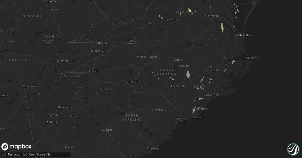
Hail Map in North Carolina on July 27, 2025
Get this storm
July 27 map
$229
one time, instant access
Download today. No call, no setup
Keep the $229
Bought the map and want the full workflow? Apply the entire $229 to a subscription within 7 days. None of it is wasted.
Every map, not just this one
This buys you this map. Subscription and you get every map we run, in the markets you choose from a few cities to whole states to nationwide. Plus real-time alerts the moment a storm fires.
Contact data
Name, contact info, occupancy, even credit band for addresses in the footprint. You go from where it hit to who to call.
Become the source they trust
Unlimited branding weather history reports on demand. You already have the documented answer ready for the property owner, and you are the one who showed up with it.
Property data and RoofTrace estimates
Pull up any address you have got, its value and the exact code rules for that jurisdiction, straight from One Click Code. Then RoofTrace estimates the squares, pitch, and roof value, priced the way you price.
Storm reports in North Carolina
North Carolina
| Date | Description |
|---|---|
| 07/27/20256:43 PM CDT | 1 tree down at us 1 and main st. |
| 07/27/20254:19 PM CDT | Approximately 75 power outages near mackleyville. |
| 07/27/20254:00 PM CDT | Craven county 911 center reported power line damage in james city. |
| 07/27/20253:41 PM CDT | Delayed report.... Duplin county dot reported a tree down across hwy 903 as thunderstorms moved through the area. Time estimated by radar. |
| 07/27/20253:15 PM CDT | Anchored outdoor furniture ripped out of the ground. |
| 07/27/20252:53 PM CDT | Power lines reported down along tyler road in kinston. |
| 07/27/20252:00 PM CDT | Tree down on a powerline on nc 168 in barco. Time estimated. |
| 07/26/20258:52 PM CDT | Duke energy reported fallen trees or powerlines damaging their equipment... Causing power outages. |
| 07/26/20258:42 PM CDT | 1 tree down at us 1 and quail ridge dr. |
| 07/26/20257:45 PM CDT | 1 tree down at martin rd and mill rd. |
| 07/26/20257:23 PM CDT | One tree down in 600 block of morgan creek rd. |
| 07/26/20257:12 PM CDT | One tree down in 200 block of s main st. |
| 07/26/20257:07 PM CDT | One tree down at jones ferry rd and damascus church rd. |
| 07/26/20257:03 PM CDT | Multiple trees down in 2300 block of white cross rd. |
All States Impacted by Hail Map on July 27, 2025
Cities Impacted by Hail Map on July 27, 2025
- Chisholm, MN
- Hibbing, MN
- Forbes, MN
- Mountain Iron, MN
- Buhl, MN
- Iron, MN
- Kinney, MN
- Britt, MN
- Pequot Lakes, MN
- Nisswa, MN
- Motley, MN
- Merrifield, MN
- Crosby, MN
- Pillager, MN
- Aitkin, MN
- Eveleth, MN
- Deerwood, MN
- Milbank, SD
- Marietta, MN
- Big Stone City, SD
- Bellingham, MN
- Odessa, MN
- Madison, MN
- Appleton, MN
- Correll, MN
- Milan, MN
- Clifton, VA
- Fairfax Station, VA
- Dawson, MN
- Watson, MN
- Montevideo, MN
- Alexandria, VA
- Danvers, MN
- Maynard, MN
- Bristow, VA
- Nokesville, VA
- Britton, SD
- Skandia, MI
- Greenville, NC
- Clara City, MN
- Clarkfield, MN
- Boyd, MN
- Eben Junction, MI
- Sacred Heart, MN
- Renville, MN
- Rumely, MI
- Deerton, MI
- Chatham, MI
- Issue, MD
- Newburg, MD
- Manassas, VA
- Jane Lew, WV
- Lost Creek, WV
- Prinsburg, MN
- Raymond, MN
- Trenary, MI
- Munising, MI
- Roper, NC
- Nelsonville, OH
- Buchtel, OH
- Glouster, OH
- Smiley, TX
- Wetmore, MI
- Linton, IN
- Hope Mills, NC
- Creswell, NC
- La Grange, NC
- Seven Springs, NC
- Goldsboro, NC
- Worthington, IN
- Jasonville, IN
- Kinston, NC
- Rochelle, VA
- Chillicothe, OH
- Fredericksburg, VA
- Spotsylvania, VA
- Manistique, MI
- Rapid River, MI
- Windsor, NC
- Flat Rock, IL
- Dover, NC
- Pinetown, NC
- Washington, NC
- Maple Hill, NC
- Pomeroy, OH
- Albany, OH
- Rutland, OH
- Newton, IL
- Mount Olive, NC
- Atkinson, NC
- Trenton, NC
- Albertson, NC
- Burgaw, NC
- Robinson, IL
- Pantego, NC
- Plymouth, NC
- Pink Hill, NC
- Palestine, IL
- Partlow, VA
- Reedville, VA
- Burgess, VA
- Heathsville, VA
- Willard, NC
- Wheaton, MN
- Kenansville, NC
- Faison, NC
- Warsaw, NC
- Hutsonville, IL
- Turkey, NC
- Brookshire, TX
- Norcross, MN
- Herman, MN
- Dumont, MN
- Donnelly, MN
- Wallis, TX
- Washington, IN
- Barry, MN
- Graceville, MN
- Beulaville, NC
- Magnolia, NC
- Kilmarnock, VA
- Beardsley, MN
- Chokio, MN
- Clinton, MN
- Fairbanks, IN
- White Stone, VA
- Wilmot, SD
- Scottsville, VA
- Hoffman, MN
- Barrett, MN
- Morris, MN
- Kensington, MN
- Farwell, MN
- Cyrus, MN
- Alberta, MN
- Arvonia, VA
- Ashland, VA
- Doswell, VA
- Cobbs Creek, VA
- Hallieford, VA
- Ortonville, MN
- Kelly, NC
- Paynesville, MN
- Freeport, MN
- Albany, MN
- New Canton, VA
- Palmyra, VA
- Lowry, MN
- Wilmington, NC
- Starbuck, MN
- Shipman, VA
- Schuyler, VA
- Wingina, VA
- Cartersville, VA
- Leland, NC
- Hancock, MN
- Gladstone, VA
- Cumberland, VA
- Glenwood, MN
- Benson, MN
- Clontarf, MN
- Holloway, MN
- Newport News, VA
- Winnabow, NC
- Pocahontas, AR
- Yorktown, VA
- Poquoson, VA
- Gainesville, VA
- Brooten, MN
- Pennock, MN
- Spicer, MN
- Belgrade, MN
- New London, MN
- Willmar, MN
- Murdock, MN
- Sunburg, MN
- Kerkhoven, MN
- Florence, SD
- Watertown, SD
- Sims, IL
- Geff, IL
- Buchanan, VA
- Virginia Beach, VA
- Spring Grove, VA
- Waverly, VA
- Henry, SD
- Charles City, VA
- Norfolk, VA
- Kandiyohi, MN
- Melrose, MN
- Lake Lillian, MN
- Grove City, MN
- Atwater, MN
- Dendron, VA
- Marvin, SD
- White Sulphur Springs, MT
- Fairfield, IL
- Wakefield, VA
- Corona, SD
- Roscoe, MN
- Eden Valley, MN
- Richmond, MN
- Litchfield, MN
- Watkins, MN
- Elberon, VA
- Twin Brooks, SD
- Bedford, VA
- Alzada, MT
- Belle Fourche, SD
- Cokato, MN
- Annandale, MN
- Kimball, MN
- South Haven, MN
- Dassel, MN
- Darwin, MN
- Howard Lake, MN
- Maple Lake, MN
- Neihart, MT
- Effie, MN
- Cook, MN
- Southern Pines, NC
- Summit, SD
- Ortley, SD
- Cuervo, NM
- South Shore, SD
- Revillo, SD
- Strandburg, SD
- Labolt, SD
- Stockholm, SD
- Orr, MN
- Gary, SD
- Monticello, MN
- Montrose, MN
- Waverly, MN
- Saint Michael, MN
- Buffalo, MN
- Watertown, MN
- Rockford, MN
- Maple Plain, MN
- Loretto, MN
- Delano, MN
- Goodwin, SD
- Kranzburg, SD
- Dutton, MT
- Power, MT
- Troy, NC
- Hitchcock, SD
- Granite City, IL
- Castlewood, SD
- Clear Lake, SD
- Hayti, SD
- Hazel, SD
- Hanover, MN
- Rogers, MN
- Maple Grove, MN
- Hamel, MN
- Minneapolis, MN
- Long Lake, MN
- Mound, MN
- Minnetonka, MN
- Chanhassen, MN
- Excelsior, MN
- Wayzata, MN
- Eden Prairie, MN
- Spring Park, MN
- Denham Springs, LA
- Hutchinson, MN
- Stewart, MN
- Buffalo Lake, MN
- Monroe, NC
- Cosmos, MN
- Valentine, NE
- Star, NC
- Denton, NC
- Mission, SD
- Winner, SD
- Hopkins, MN
- Osseo, MN
- Canby, MN
- Waubay, SD
- Geyser, MT
- Saint Paul, MN
- Glencoe, MN
- Biscoe, NC
- Candor, NC
- Bradenton, FL
- Hector, MN
- Silver Lake, MN
- Brownton, MN
- Minneota, MN
- Granite Falls, MN
- Taunton, MN
- Porter, MN
- Brandt, SD
- Hendricks, MN
- Ivanhoe, MN
- Toronto, SD
- Estelline, SD
- Astoria, SD
- Lake Norden, SD
- Vienna, SD
- Hanley Falls, MN
- Cottonwood, MN
- Colome, SD
- Echo, MN
- Wood Lake, MN
- Marshall, MN
- Geraldine, MT
- Stillwater, MN
- Cut Bank, MT
- Pukwana, SD
- Chamberlain, SD
- Sarasota, FL
- Plato, MN
- Lake Elmo, MN
- Willernie, MN
- South Saint Paul, MN
- Bayport, MN
- Afton, MN
- Lakeland, MN
- Newport, MN
- Belle Plaine, MN
- Norwood Young America, MN
- Henderson, MN
- Two Dot, MT
- Green Isle, MN
- Hamburg, MN
- Wessington Springs, SD
- Sweet Grass, MT
- Yale, SD
- Lester Prairie, MN
- New Auburn, MN
- Blomkest, MN
- Olivia, MN
- Danube, MN
- Somerset, WI
- Marine On Saint Croix, MN
- Hugo, MN
- Houlton, WI
- Bird Island, MN
- Belview, MN
- Redwood Falls, MN
- Lucan, MN
- Morton, MN
- Vesta, MN
- Seaforth, MN
- Milroy, MN
- Wabasso, MN
- Dayton, NV
- Virginia City, NV
- Cologne, MN
- Carver, MN
- Jordan, MN
- Gibbon, MN
- Fairfax, MN
- Franklin, MN
- Arlington, MN
- Winthrop, MN
- Morgan, MN
- Gaylord, MN
- Clements, MN
- Lafayette, MN
- Le Sueur, MN
- Sleepy Eye, MN
- New Ulm, MN
- Nicollet, MN
- Saint Peter, MN
- Marshville, NC
- Adrian, OR
- Judith Gap, MT
- Sunburst, MT
- Fort Thompson, SD
- Oacoma, SD
- Cottage Grove, MN
- Saint Paul Park, MN
- Shelby, MT
- Zortman, MT
- Hays, MT
- Ghent, MN
- Young America, MN
- Waconia, MN
- New Germany, MN
- Mayer, MN
- Chaska, MN
- Victoria, MN
- Shakopee, MN
- New Prague, MN
- Lakeville, MN
- Prior Lake, MN
- Burnsville, MN
- Le Center, MN
- Savage, MN
- Lonsdale, MN
- Elysian, MN
- Madison Lake, MN
- Cleveland, MN
- Waterville, MN
- Janesville, MN
- Elko New Market, MN
- Kilkenny, MN
- Webster, MN
- Montgomery, MN
- Kasota, MN
- Lloyd, MT
- Sanford, NC
- Cameron, NC
- Ryegate, MT
- Lavina, MT
- Garden City, SD
- Pageland, SC
- Moweaqua, IL
- Kershaw, SC
- Woonsocket, SD
- Kimball, SD
- Farmington, MN
- Alpena, SD
- Mount Croghan, SC
- Buffalo, MT
- Lynd, MN
- Lewistown, MT
- Bryant, SD
- Artesian, SD
- Northfield, MN
- Randolph, MN
- Dundas, MN
- Rosemount, MN
- Faribault, MN
- Morristown, MN
- Mankato, MN
- Eagle Lake, MN
- Good Thunder, MN
- Saint Clair, MN
- Mapleton, MN
- Amboy, MN
- Lake Crystal, MN
- Garden City, MN
- Clark, SD
- Letcher, SD
- Currie, MN
- Slayton, MN
- Mount Vernon, SD
- Fulton, SD
- Mitchell, SD
- Waseca, MN
- Chester, MT
- Reno, NV
- Russell, MN
- Bruce, SD
- White, SD
- Westbrook, MN
- Brookings, SD
- Bonaparte, IA
- Farmington, IA
- Donnellson, IA
- Ellendale, MN
- New Richland, MN
- Fedora, SD
- Avoca, MN
- Smithfield, NC
- Clayton, NC
- Owatonna, MN
- Hope, MN
- Blooming Prairie, MN
- Dennison, MN
- Nerstrand, MN
- Warsaw, MN
- Kenyon, MN
- Medford, MN
- Claremont, MN
- Mantorville, MN
- Dodge Center, MN
- West Concord, MN
- Bricelyn, MN
- Delavan, MN
- Elmore, MN
- Wells, MN
- Blue Earth, MN
- Waldorf, MN
- Frost, MN
- Easton, MN
- Winnebago, MN
- Freeborn, MN
- Alden, MN
- Pemberton, MN
- Granada, MN
- Minnesota Lake, MN
- Hartland, MN
- Kasson, MN
- Vernon Center, MN
- Howard, SD
- Alexandria, SD
- Canova, SD
- Salem, SD
- Spencer, SD
- Geneva, MN
- Clarks Grove, MN
- Albert Lea, MN
- Kiester, MN
- Lake Benton, MN
- Four Oaks, NC
- Benson, NC
- Arco, MN
- Waltham, MN
- Austin, MN
- Elkton, SD
- Tyler, MN
- Balaton, MN
- Stickney, SD
- Garvin, MN
- Arlington, SD
- Montrose, SD
- Lake Wilson, MN
- Woodstock, MN
- Edgerton, MN
- Winfred, SD
- Humboldt, SD
- Hartford, SD
- Canistota, SD
- Crooks, SD
- Sioux Falls, SD
- Hayfield, MN
- Pipestone, MN
- Chandler, MN
- Hollandale, MN
- Glenville, MN
- Hayward, MN
- Conger, MN
- Twin Lakes, MN
- Stacyville, IA
- Rose Creek, MN
- Emmons, MN
- Saint Ansgar, IA
- Lyle, MN
- Lone Rock, IA
- Whittemore, IA
- Ledyard, IA
- Carpenter, IA
- Joice, IA
- Leland, IA
- Swea City, IA
- Buffalo Center, IA
- Wesley, IA
- Lake Mills, IA
- Lakota, IA
- Kensett, IA
- Britt, IA
- Forest City, IA
- Rake, IA
- Titonka, IA
- Algona, IA
- Northwood, IA
- Thompson, IA
- West Bend, IA
- Bancroft, IA
- Crystal Lake, IA
- Woden, IA
- Burt, IA
- Scarville, IA
- Hanlontown, IA
- Garner, IA
- Goodell, IA
- Fertile, IA
- Osage, IA
- Klemme, IA
- Kanawha, IA
- Clear Lake, IA
- Manly, IA
- Ventura, IA
- Lu Verne, IA
- Corwith, IA
- Thornton, IA
- Mason City, IA
- Grafton, IA
- Plymouth, IA
- Brandon, SD
- Harrisburg, SD
- Trent, SD
- Dell Rapids, SD
- Flandreau, SD
- Havre, MT
- Kremlin, MT
- Forest Grove, MT
- Chinook, MT
- Cylinder, IA
- Rock Rapids, IA
- Beaver Creek, MN
- Hills, MN
- Larchwood, IA
- Steen, MN
- Luverne, MN
- Martinsdale, MT
- Inwood, IA
- Lester, IA
- Alvord, IA
- Canton, SD
- Hartley, IA
- Sheldon, IA
- Boyden, IA
- Alexander, IA
- Woolstock, IA
- Rock Falls, IA
- Hampton, IA
- Orchard, IA
- Eagle Grove, IA
- Rockford, IA
- Rudd, IA
- Charles City, IA
- Latimer, IA
- Clarion, IA
- Little Cedar, IA
- Galt, IA
- Goldfield, IA
- Ottosen, IA
- Dows, IA
- Marble Rock, IA
- Meservey, IA
- Bode, IA
- Nora Springs, IA
- Williams, IA
- Chapin, IA
- Colwell, IA
- Floyd, IA
- Livermore, IA
- Belmond, IA
- Blairsburg, IA
- Dougherty, IA
- Coulter, IA
- Sheffield, IA
- Rockwell, IA
- Hardy, IA
- Riceville, IA
- Rowan, IA
- Swaledale, IA
- Renwick, IA
- Clarksville, IA
- Dumont, IA
- Bristow, IA
- Aredale, IA
- Greene, IA
- Iowa Falls, IA
- Geneva, IA
- Alden, IA
- Allison, IA
- Rutland, IA
- Badger, IA
- Bradford, IA
- Rolfe, IA
- Gilmore City, IA
- Humboldt, IA
- Vincent, IA
- Dakota City, IA
- Bradgate, IA
- Thor, IA
- Pocahontas, IA
- Fort Dodge, IA
- Popejoy, IA
- Clare, IA
- Duncombe, IA
- Webster City, IA
- Mallard, IA
- Valley Springs, SD
- Adrian, MN
- Rushmore, MN
- Sibley, IA
- Kanaranzi, MN
- Ellsworth, MN
- Little Rock, IA
- Magnolia, MN
- Ocheyedan, IA
- George, IA
- Granville, IA
- Matlock, IA
- Paullina, IA
- Le Mars, IA
- Archer, IA
- Melvin, IA
- Hull, IA
- Doon, IA
- Primghar, IA
- Rock Valley, IA
- Sioux Center, IA
- Hawarden, IA
- Marcus, IA
- Maurice, IA
- Hospers, IA
- Ireton, IA
- Orange City, IA
- Sanborn, IA
- Ashton, IA
- Remsen, IA
- Alton, IA
- Fairview, SD
- Waucoma, IA
- Lawler, IA
- Circle, MT
- Fort Atkinson, IA
- West Union, IA
- Hawkeye, IA
- Merrill, IA
- Dodson, MT
- Malta, MT
- Elgin, IA
- Harris, IA
- Everly, IA
- Arthur, IA
- Holstein, IA
- Peterson, IA
- Galva, IA
- Royal, IA
- Washta, IA
- Larrabee, IA
- Pierson, IA
- Ida Grove, IA
- Kingsley, IA
- Early, IA
- Quimby, IA
- Meriden, IA
- Cleghorn, IA
- Schaller, IA
- Storm Lake, IA
- Battle Creek, IA
- Correctionville, IA
- Odebolt, IA
- Sutherland, IA
- Linn Grove, IA
- Cherokee, IA
- Calumet, IA
- Alta, IA
- Aurelia, IA
- Cushing, IA
- Rembrandt, IA
- Marathon, IA
- Greenville, IA
- Milford, IA
- Truesdale, IA
- Albert City, IA
- Nemaha, IA
- Sioux Rapids, IA
- Spencer, IA
- Webb, IA
- Newell, IA
- Varina, IA
- Fonda, IA
- Wall Lake, IA
- Sac City, IA
- Lytton, IA
- Lake View, IA
- Hinton, IA
- Cohagen, MT
- Dubuque, IA
- Fort Peck, MT
- Zwingle, IA
- Bellevue, IA
- Langsville, OH
- La Motte, IA
- Brockway, MT
- Lindsay, MT
- Bloomfield, MT
- Glendive, MT
- Hillsboro, IA
- Wibaux, MT
- Savage, MT
- Cartwright, ND
- Beach, ND
- Grassy Butte, ND
- Sentinel Butte, ND
- Galata, MT
- Whitlash, MT
- Joplin, MT
- Moville, IA
- Waterloo, IA
- Sumner, IA
- Denver, IA
- Dunkerton, IA
- Waverly, IA
- Cedar Falls, IA
- Tripoli, IA
- Janesville, IA
- Readlyn, IA
- Westgate, IA
- Oran, IA
- Fairbank, IA
- Evansdale, IA
- Dewar, IA
- Ringsted, IA


