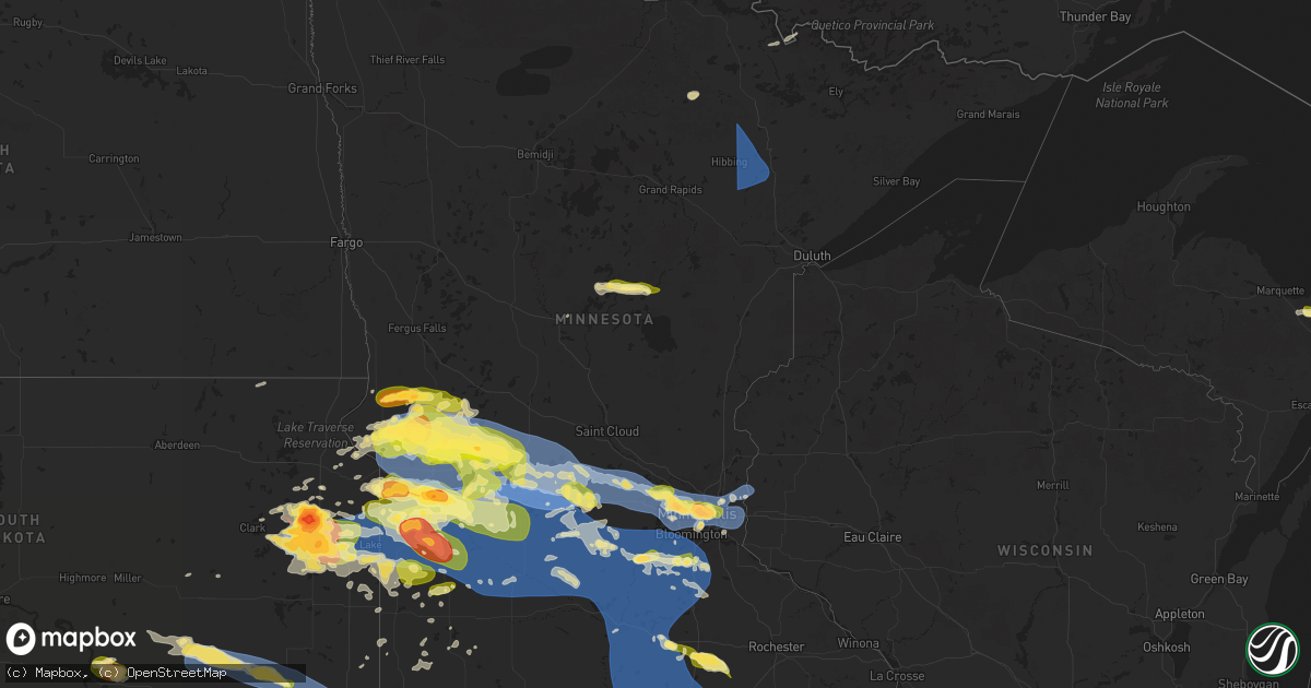
Hail Map in Minnesota on July 27, 2025
Get this storm
July 27 map
$229
one time, instant access
Download today. No call, no setup
Keep the $229
Bought the map and want the full workflow? Apply the entire $229 to a subscription within 7 days. None of it is wasted.
Every map, not just this one
This buys you this map. Subscription and you get every map we run, in the markets you choose from a few cities to whole states to nationwide. Plus real-time alerts the moment a storm fires.
Contact data
Name, contact info, occupancy, even credit band for addresses in the footprint. You go from where it hit to who to call.
Become the source they trust
Unlimited branding weather history reports on demand. You already have the documented answer ready for the property owner, and you are the one who showed up with it.
Property data and RoofTrace estimates
Pull up any address you have got, its value and the exact code rules for that jurisdiction, straight from One Click Code. Then RoofTrace estimates the squares, pitch, and roof value, priced the way you price.
Storm reports in Minnesota
Minnesota
| Date | Description |
|---|---|
| 07/27/20256:18 PM CDT | A local report indicates 1.00 inch wind near Chokio |
| 07/27/20255:45 PM CDT | A local report indicates 1.50 inch wind near Johnson |
| 07/27/20255:40 PM CDT | Grain bins buckled near sunburg. |
| 07/27/20255:35 PM CDT | Mesonet station mn136 t.h.9 - murdock - mp 24.5. |
| 07/27/20255:25 PM CDT | Mesonet station mn136 t.h.9 - murdock - mp 24.5. |
| 07/27/20255:20 PM CDT | Mesonet station mn037 t.h.29 - starbuck - mp 46. |
| 07/27/20255:20 PM CDT | Mesonet station mn134 u.s.12 - holloway - mp 27.0. |
| 07/27/20255:18 PM CDT | Multiple large branches down. |
| 07/27/20255:04 PM CDT | Power poles down in and near chokio. |
| 07/27/20254:57 PM CDT | A local report indicates 1.25 inch wind near Morris |
| 07/27/20254:46 PM CDT | A local report indicates 1.00 inch wind near Alberta |
| 07/27/20254:46 PM CDT | Measured at morris municipal airport. |
| 07/27/20254:45 PM CDT | A local report indicates 1.00 inch wind near Alberta |
| 07/27/20254:43 PM CDT | Relayed via em. |
| 07/27/20254:31 PM CDT | A local report indicates 60 MPH wind near Chokio |
| 07/27/20254:12 PM CDT | A local report indicates 1.50 inch wind near Herman |
| 07/27/20254:05 PM CDT | Ndawn station reporting 10 m |
| 07/27/202512:50 PM CDT | Large trees and power lines down near the city of watson. Time estimated from radar. |
| 07/27/202512:39 PM CDT | Photos on social media of snapped power pole and several large tree limbs down onto a house. |
| 07/27/202512:37 PM CDT | Report of numerous large trees down between milan and chippewa county road 32. Time estimated from radar. |
| 07/27/202512:25 PM CDT | Report of tornado southwest of appleton near the minnesota river. |
| 07/27/202512:03 PM CDT | Mostly nickel sized hail but a few quarters also. |
| 07/27/20257:55 AM CDT | A local report indicates 1.00 inch wind near 1 ESE Aitkin |
| 07/27/20257:53 AM CDT | Hail currently falling with not much wind. |
| 07/27/20257:17 AM CDT | Public report relayed via broadcast media partner. Picture of an uprooted tree fallen onto the street. |
| 07/27/20257:16 AM CDT | Pictures via social media of a couple uprooted and broken trees. Time estimated from radar. |
| 07/27/20257:04 AM CDT | *** 1 inj *** a tree fell at a campground on stubler lake landing on a tent and injuring a 7 year old boy. |
| 07/26/202511:35 PM CDT | Mesonet station mn144 u.s.218 - lyle - mp 4. |
| 07/26/202511:25 PM CDT | Mesonet station mn144 us 218 at lyle at mp 4. |
| 07/26/202510:50 PM CDT | Downed trees. Time estimated via radar. |
| 07/26/20259:25 PM CDT | A local report indicates 1.00 inch wind near Marshall |
| 07/26/20259:14 PM CDT | A local report indicates 1.00 inch wind near 3 SW Lakeville |
| 07/26/20258:20 PM CDT | Relayed via fsd. |
| 07/26/20258:16 PM CDT | Asos station kstp st. Paul dwtn ap. |
| 07/26/20258:04 PM CDT | A local report indicates 60 MPH wind near 1 SSW Roseville |
| 07/26/20258:03 PM CDT | Report from mping: quarter |
| 07/26/20258:03 PM CDT | A local report indicates 1.75 inch wind near 2 ESE Falcon Heights |
| 07/26/20258:02 PM CDT | Corrects previous non-tstm wnd dmg report from 3 wnw mendota. Multiple trees down taking down power lines with time estimated based on radar. |
| 07/26/20258:02 PM CDT | Corrects previous non-tstm wnd dmg report from 3 wnw mendota. Multiple trees down taking down power lines with time estimated based on radar. (mp |
| 07/26/20257:51 PM CDT | A local report indicates 1.75 inch wind near Plymouth |
| 07/26/20257:48 PM CDT | Asos station kmic crystal ap. |
| 07/26/20257:47 PM CDT | Report from mping: half dollar |
| 07/26/20257:40 PM CDT | A local report indicates 1.00 inch wind near Plymouth |
| 07/26/20257:29 PM CDT | A local report indicates 1.25 inch wind near 1 N Litchfield |
| 07/26/20257:05 PM CDT | A local report indicates 61 MPH wind near 2 ESE Buffalo |
All States Impacted by Hail Map on July 27, 2025
Cities Impacted by Hail Map on July 27, 2025
- Chisholm, MN
- Hibbing, MN
- Forbes, MN
- Mountain Iron, MN
- Buhl, MN
- Iron, MN
- Kinney, MN
- Britt, MN
- Pequot Lakes, MN
- Nisswa, MN
- Motley, MN
- Merrifield, MN
- Crosby, MN
- Pillager, MN
- Aitkin, MN
- Eveleth, MN
- Deerwood, MN
- Milbank, SD
- Marietta, MN
- Big Stone City, SD
- Bellingham, MN
- Odessa, MN
- Madison, MN
- Appleton, MN
- Correll, MN
- Milan, MN
- Clifton, VA
- Fairfax Station, VA
- Dawson, MN
- Watson, MN
- Montevideo, MN
- Alexandria, VA
- Danvers, MN
- Maynard, MN
- Bristow, VA
- Nokesville, VA
- Britton, SD
- Skandia, MI
- Greenville, NC
- Clara City, MN
- Clarkfield, MN
- Boyd, MN
- Eben Junction, MI
- Sacred Heart, MN
- Renville, MN
- Rumely, MI
- Deerton, MI
- Chatham, MI
- Issue, MD
- Newburg, MD
- Manassas, VA
- Jane Lew, WV
- Lost Creek, WV
- Prinsburg, MN
- Raymond, MN
- Trenary, MI
- Munising, MI
- Roper, NC
- Nelsonville, OH
- Buchtel, OH
- Glouster, OH
- Smiley, TX
- Wetmore, MI
- Linton, IN
- Hope Mills, NC
- Creswell, NC
- La Grange, NC
- Seven Springs, NC
- Goldsboro, NC
- Worthington, IN
- Jasonville, IN
- Kinston, NC
- Rochelle, VA
- Chillicothe, OH
- Fredericksburg, VA
- Spotsylvania, VA
- Manistique, MI
- Rapid River, MI
- Windsor, NC
- Flat Rock, IL
- Dover, NC
- Pinetown, NC
- Washington, NC
- Maple Hill, NC
- Pomeroy, OH
- Albany, OH
- Rutland, OH
- Newton, IL
- Mount Olive, NC
- Atkinson, NC
- Trenton, NC
- Albertson, NC
- Burgaw, NC
- Robinson, IL
- Pantego, NC
- Plymouth, NC
- Pink Hill, NC
- Palestine, IL
- Partlow, VA
- Reedville, VA
- Burgess, VA
- Heathsville, VA
- Willard, NC
- Wheaton, MN
- Kenansville, NC
- Faison, NC
- Warsaw, NC
- Hutsonville, IL
- Turkey, NC
- Brookshire, TX
- Norcross, MN
- Herman, MN
- Dumont, MN
- Donnelly, MN
- Wallis, TX
- Washington, IN
- Barry, MN
- Graceville, MN
- Beulaville, NC
- Magnolia, NC
- Kilmarnock, VA
- Beardsley, MN
- Chokio, MN
- Clinton, MN
- Fairbanks, IN
- White Stone, VA
- Wilmot, SD
- Scottsville, VA
- Hoffman, MN
- Barrett, MN
- Morris, MN
- Kensington, MN
- Farwell, MN
- Cyrus, MN
- Alberta, MN
- Arvonia, VA
- Ashland, VA
- Doswell, VA
- Cobbs Creek, VA
- Hallieford, VA
- Ortonville, MN
- Kelly, NC
- Paynesville, MN
- Freeport, MN
- Albany, MN
- New Canton, VA
- Palmyra, VA
- Lowry, MN
- Wilmington, NC
- Starbuck, MN
- Shipman, VA
- Schuyler, VA
- Wingina, VA
- Cartersville, VA
- Leland, NC
- Hancock, MN
- Gladstone, VA
- Cumberland, VA
- Glenwood, MN
- Benson, MN
- Clontarf, MN
- Holloway, MN
- Newport News, VA
- Winnabow, NC
- Pocahontas, AR
- Yorktown, VA
- Poquoson, VA
- Gainesville, VA
- Brooten, MN
- Pennock, MN
- Spicer, MN
- Belgrade, MN
- New London, MN
- Willmar, MN
- Murdock, MN
- Sunburg, MN
- Kerkhoven, MN
- Florence, SD
- Watertown, SD
- Sims, IL
- Geff, IL
- Buchanan, VA
- Virginia Beach, VA
- Spring Grove, VA
- Waverly, VA
- Henry, SD
- Charles City, VA
- Norfolk, VA
- Kandiyohi, MN
- Melrose, MN
- Lake Lillian, MN
- Grove City, MN
- Atwater, MN
- Dendron, VA
- Marvin, SD
- White Sulphur Springs, MT
- Fairfield, IL
- Wakefield, VA
- Corona, SD
- Roscoe, MN
- Eden Valley, MN
- Richmond, MN
- Litchfield, MN
- Watkins, MN
- Elberon, VA
- Twin Brooks, SD
- Bedford, VA
- Alzada, MT
- Belle Fourche, SD
- Cokato, MN
- Annandale, MN
- Kimball, MN
- South Haven, MN
- Dassel, MN
- Darwin, MN
- Howard Lake, MN
- Maple Lake, MN
- Neihart, MT
- Effie, MN
- Cook, MN
- Southern Pines, NC
- Summit, SD
- Ortley, SD
- Cuervo, NM
- South Shore, SD
- Revillo, SD
- Strandburg, SD
- Labolt, SD
- Stockholm, SD
- Orr, MN
- Gary, SD
- Monticello, MN
- Montrose, MN
- Waverly, MN
- Saint Michael, MN
- Buffalo, MN
- Watertown, MN
- Rockford, MN
- Maple Plain, MN
- Loretto, MN
- Delano, MN
- Goodwin, SD
- Kranzburg, SD
- Dutton, MT
- Power, MT
- Troy, NC
- Hitchcock, SD
- Granite City, IL
- Castlewood, SD
- Clear Lake, SD
- Hayti, SD
- Hazel, SD
- Hanover, MN
- Rogers, MN
- Maple Grove, MN
- Hamel, MN
- Minneapolis, MN
- Long Lake, MN
- Mound, MN
- Minnetonka, MN
- Chanhassen, MN
- Excelsior, MN
- Wayzata, MN
- Eden Prairie, MN
- Spring Park, MN
- Denham Springs, LA
- Hutchinson, MN
- Stewart, MN
- Buffalo Lake, MN
- Monroe, NC
- Cosmos, MN
- Valentine, NE
- Star, NC
- Denton, NC
- Mission, SD
- Winner, SD
- Hopkins, MN
- Osseo, MN
- Canby, MN
- Waubay, SD
- Geyser, MT
- Saint Paul, MN
- Glencoe, MN
- Biscoe, NC
- Candor, NC
- Bradenton, FL
- Hector, MN
- Silver Lake, MN
- Brownton, MN
- Minneota, MN
- Granite Falls, MN
- Taunton, MN
- Porter, MN
- Brandt, SD
- Hendricks, MN
- Ivanhoe, MN
- Toronto, SD
- Estelline, SD
- Astoria, SD
- Lake Norden, SD
- Vienna, SD
- Hanley Falls, MN
- Cottonwood, MN
- Colome, SD
- Echo, MN
- Wood Lake, MN
- Marshall, MN
- Geraldine, MT
- Stillwater, MN
- Cut Bank, MT
- Pukwana, SD
- Chamberlain, SD
- Sarasota, FL
- Plato, MN
- Lake Elmo, MN
- Willernie, MN
- South Saint Paul, MN
- Bayport, MN
- Afton, MN
- Lakeland, MN
- Newport, MN
- Belle Plaine, MN
- Norwood Young America, MN
- Henderson, MN
- Two Dot, MT
- Green Isle, MN
- Hamburg, MN
- Wessington Springs, SD
- Sweet Grass, MT
- Yale, SD
- Lester Prairie, MN
- New Auburn, MN
- Blomkest, MN
- Olivia, MN
- Danube, MN
- Somerset, WI
- Marine On Saint Croix, MN
- Hugo, MN
- Houlton, WI
- Bird Island, MN
- Belview, MN
- Redwood Falls, MN
- Lucan, MN
- Morton, MN
- Vesta, MN
- Seaforth, MN
- Milroy, MN
- Wabasso, MN
- Dayton, NV
- Virginia City, NV
- Cologne, MN
- Carver, MN
- Jordan, MN
- Gibbon, MN
- Fairfax, MN
- Franklin, MN
- Arlington, MN
- Winthrop, MN
- Morgan, MN
- Gaylord, MN
- Clements, MN
- Lafayette, MN
- Le Sueur, MN
- Sleepy Eye, MN
- New Ulm, MN
- Nicollet, MN
- Saint Peter, MN
- Marshville, NC
- Adrian, OR
- Judith Gap, MT
- Sunburst, MT
- Fort Thompson, SD
- Oacoma, SD
- Cottage Grove, MN
- Saint Paul Park, MN
- Shelby, MT
- Zortman, MT
- Hays, MT
- Ghent, MN
- Young America, MN
- Waconia, MN
- New Germany, MN
- Mayer, MN
- Chaska, MN
- Victoria, MN
- Shakopee, MN
- New Prague, MN
- Lakeville, MN
- Prior Lake, MN
- Burnsville, MN
- Le Center, MN
- Savage, MN
- Lonsdale, MN
- Elysian, MN
- Madison Lake, MN
- Cleveland, MN
- Waterville, MN
- Janesville, MN
- Elko New Market, MN
- Kilkenny, MN
- Webster, MN
- Montgomery, MN
- Kasota, MN
- Lloyd, MT
- Sanford, NC
- Cameron, NC
- Ryegate, MT
- Lavina, MT
- Garden City, SD
- Pageland, SC
- Moweaqua, IL
- Kershaw, SC
- Woonsocket, SD
- Kimball, SD
- Farmington, MN
- Alpena, SD
- Mount Croghan, SC
- Buffalo, MT
- Lynd, MN
- Lewistown, MT
- Bryant, SD
- Artesian, SD
- Northfield, MN
- Randolph, MN
- Dundas, MN
- Rosemount, MN
- Faribault, MN
- Morristown, MN
- Mankato, MN
- Eagle Lake, MN
- Good Thunder, MN
- Saint Clair, MN
- Mapleton, MN
- Amboy, MN
- Lake Crystal, MN
- Garden City, MN
- Clark, SD
- Letcher, SD
- Currie, MN
- Slayton, MN
- Mount Vernon, SD
- Fulton, SD
- Mitchell, SD
- Waseca, MN
- Chester, MT
- Reno, NV
- Russell, MN
- Bruce, SD
- White, SD
- Westbrook, MN
- Brookings, SD
- Bonaparte, IA
- Farmington, IA
- Donnellson, IA
- Ellendale, MN
- New Richland, MN
- Fedora, SD
- Avoca, MN
- Smithfield, NC
- Clayton, NC
- Owatonna, MN
- Hope, MN
- Blooming Prairie, MN
- Dennison, MN
- Nerstrand, MN
- Warsaw, MN
- Kenyon, MN
- Medford, MN
- Claremont, MN
- Mantorville, MN
- Dodge Center, MN
- West Concord, MN
- Bricelyn, MN
- Delavan, MN
- Elmore, MN
- Wells, MN
- Blue Earth, MN
- Waldorf, MN
- Frost, MN
- Easton, MN
- Winnebago, MN
- Freeborn, MN
- Alden, MN
- Pemberton, MN
- Granada, MN
- Minnesota Lake, MN
- Hartland, MN
- Kasson, MN
- Vernon Center, MN
- Howard, SD
- Alexandria, SD
- Canova, SD
- Salem, SD
- Spencer, SD
- Geneva, MN
- Clarks Grove, MN
- Albert Lea, MN
- Kiester, MN
- Lake Benton, MN
- Four Oaks, NC
- Benson, NC
- Arco, MN
- Waltham, MN
- Austin, MN
- Elkton, SD
- Tyler, MN
- Balaton, MN
- Stickney, SD
- Garvin, MN
- Arlington, SD
- Montrose, SD
- Lake Wilson, MN
- Woodstock, MN
- Edgerton, MN
- Winfred, SD
- Humboldt, SD
- Hartford, SD
- Canistota, SD
- Crooks, SD
- Sioux Falls, SD
- Hayfield, MN
- Pipestone, MN
- Chandler, MN
- Hollandale, MN
- Glenville, MN
- Hayward, MN
- Conger, MN
- Twin Lakes, MN
- Stacyville, IA
- Rose Creek, MN
- Emmons, MN
- Saint Ansgar, IA
- Lyle, MN
- Lone Rock, IA
- Whittemore, IA
- Ledyard, IA
- Carpenter, IA
- Joice, IA
- Leland, IA
- Swea City, IA
- Buffalo Center, IA
- Wesley, IA
- Lake Mills, IA
- Lakota, IA
- Kensett, IA
- Britt, IA
- Forest City, IA
- Rake, IA
- Titonka, IA
- Algona, IA
- Northwood, IA
- Thompson, IA
- West Bend, IA
- Bancroft, IA
- Crystal Lake, IA
- Woden, IA
- Burt, IA
- Scarville, IA
- Hanlontown, IA
- Garner, IA
- Goodell, IA
- Fertile, IA
- Osage, IA
- Klemme, IA
- Kanawha, IA
- Clear Lake, IA
- Manly, IA
- Ventura, IA
- Lu Verne, IA
- Corwith, IA
- Thornton, IA
- Mason City, IA
- Grafton, IA
- Plymouth, IA
- Brandon, SD
- Harrisburg, SD
- Trent, SD
- Dell Rapids, SD
- Flandreau, SD
- Havre, MT
- Kremlin, MT
- Forest Grove, MT
- Chinook, MT
- Cylinder, IA
- Rock Rapids, IA
- Beaver Creek, MN
- Hills, MN
- Larchwood, IA
- Steen, MN
- Luverne, MN
- Martinsdale, MT
- Inwood, IA
- Lester, IA
- Alvord, IA
- Canton, SD
- Hartley, IA
- Sheldon, IA
- Boyden, IA
- Alexander, IA
- Woolstock, IA
- Rock Falls, IA
- Hampton, IA
- Orchard, IA
- Eagle Grove, IA
- Rockford, IA
- Rudd, IA
- Charles City, IA
- Latimer, IA
- Clarion, IA
- Little Cedar, IA
- Galt, IA
- Goldfield, IA
- Ottosen, IA
- Dows, IA
- Marble Rock, IA
- Meservey, IA
- Bode, IA
- Nora Springs, IA
- Williams, IA
- Chapin, IA
- Colwell, IA
- Floyd, IA
- Livermore, IA
- Belmond, IA
- Blairsburg, IA
- Dougherty, IA
- Coulter, IA
- Sheffield, IA
- Rockwell, IA
- Hardy, IA
- Riceville, IA
- Rowan, IA
- Swaledale, IA
- Renwick, IA
- Clarksville, IA
- Dumont, IA
- Bristow, IA
- Aredale, IA
- Greene, IA
- Iowa Falls, IA
- Geneva, IA
- Alden, IA
- Allison, IA
- Rutland, IA
- Badger, IA
- Bradford, IA
- Rolfe, IA
- Gilmore City, IA
- Humboldt, IA
- Vincent, IA
- Dakota City, IA
- Bradgate, IA
- Thor, IA
- Pocahontas, IA
- Fort Dodge, IA
- Popejoy, IA
- Clare, IA
- Duncombe, IA
- Webster City, IA
- Mallard, IA
- Valley Springs, SD
- Adrian, MN
- Rushmore, MN
- Sibley, IA
- Kanaranzi, MN
- Ellsworth, MN
- Little Rock, IA
- Magnolia, MN
- Ocheyedan, IA
- George, IA
- Granville, IA
- Matlock, IA
- Paullina, IA
- Le Mars, IA
- Archer, IA
- Melvin, IA
- Hull, IA
- Doon, IA
- Primghar, IA
- Rock Valley, IA
- Sioux Center, IA
- Hawarden, IA
- Marcus, IA
- Maurice, IA
- Hospers, IA
- Ireton, IA
- Orange City, IA
- Sanborn, IA
- Ashton, IA
- Remsen, IA
- Alton, IA
- Fairview, SD
- Waucoma, IA
- Lawler, IA
- Circle, MT
- Fort Atkinson, IA
- West Union, IA
- Hawkeye, IA
- Merrill, IA
- Dodson, MT
- Malta, MT
- Elgin, IA
- Harris, IA
- Everly, IA
- Arthur, IA
- Holstein, IA
- Peterson, IA
- Galva, IA
- Royal, IA
- Washta, IA
- Larrabee, IA
- Pierson, IA
- Ida Grove, IA
- Kingsley, IA
- Early, IA
- Quimby, IA
- Meriden, IA
- Cleghorn, IA
- Schaller, IA
- Storm Lake, IA
- Battle Creek, IA
- Correctionville, IA
- Odebolt, IA
- Sutherland, IA
- Linn Grove, IA
- Cherokee, IA
- Calumet, IA
- Alta, IA
- Aurelia, IA
- Cushing, IA
- Rembrandt, IA
- Marathon, IA
- Greenville, IA
- Milford, IA
- Truesdale, IA
- Albert City, IA
- Nemaha, IA
- Sioux Rapids, IA
- Spencer, IA
- Webb, IA
- Newell, IA
- Varina, IA
- Fonda, IA
- Wall Lake, IA
- Sac City, IA
- Lytton, IA
- Lake View, IA
- Hinton, IA
- Cohagen, MT
- Dubuque, IA
- Fort Peck, MT
- Zwingle, IA
- Bellevue, IA
- Langsville, OH
- La Motte, IA
- Brockway, MT
- Lindsay, MT
- Bloomfield, MT
- Glendive, MT
- Hillsboro, IA
- Wibaux, MT
- Savage, MT
- Cartwright, ND
- Beach, ND
- Grassy Butte, ND
- Sentinel Butte, ND
- Galata, MT
- Whitlash, MT
- Joplin, MT
- Moville, IA
- Waterloo, IA
- Sumner, IA
- Denver, IA
- Dunkerton, IA
- Waverly, IA
- Cedar Falls, IA
- Tripoli, IA
- Janesville, IA
- Readlyn, IA
- Westgate, IA
- Oran, IA
- Fairbank, IA
- Evansdale, IA
- Dewar, IA
- Ringsted, IA


