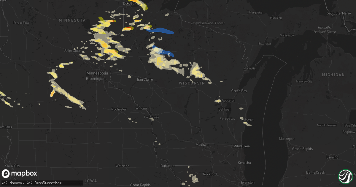
Hail Map in Wisconsin on July 27, 2023
Get this storm
July 27 map
$229
one time, instant access
Download today. No call, no setup
Keep the $229
Bought the map and want the full workflow? Apply the entire $229 to a subscription within 7 days. None of it is wasted.
Every map, not just this one
This buys you this map. Subscription and you get every map we run, in the markets you choose from a few cities to whole states to nationwide. Plus real-time alerts the moment a storm fires.
Contact data
Name, contact info, occupancy, even credit band for addresses in the footprint. You go from where it hit to who to call.
Become the source they trust
Unlimited branding weather history reports on demand. You already have the documented answer ready for the property owner, and you are the one who showed up with it.
Property data and RoofTrace estimates
Pull up any address you have got, its value and the exact code rules for that jurisdiction, straight from One Click Code. Then RoofTrace estimates the squares, pitch, and roof value, priced the way you price.
Storm reports in Wisconsin
Wisconsin
| Date | Description |
|---|---|
| 07/27/20236:56 PM CDT | Social media report with photos of a spruce tree top that had a diameter of approximately 8 inches. Time estimated based on radar. |
| 07/27/20236:34 PM CDT | 2-3 inch diameter branches down. |
| 07/27/20236:25 PM CDT | Several areas in shell lake with trees down across the roadway. Time estimated from radar. |
| 07/27/20236:23 PM CDT | Trees down across roadway. Time estimated from radar. |
| 07/27/20235:55 PM CDT | Delayed report... Time estimated from radar. Several reports of trees and powerlines down with outages near hawkins. |
| 07/27/20235:50 PM CDT | Tree down... Picture via social media. |
| 07/27/20235:34 PM CDT | Storms resulted in trees down and a barn window blown in. Time estimated from radar. |
| 07/27/20235:30 PM CDT | Medium to large poplar trees snapped about 10 feet from the ground. Observe reports gusting swirling trees and 1.4 inches of rain. Time estimated from radar. |
| 07/27/20235:25 PM CDT | Tree down on powerline causing fire. Time estimated via radar. |
| 07/27/20235:20 PM CDT | Fallen medium to large trees blocking an entrance to black lake campground. Time estimated from radar. |
| 07/27/20235:06 PM CDT | Trees down on powerlines between casino and lake road. Time estimated from radar. |
| 07/27/20235:05 PM CDT | 10 inch diameter aspen tree snaped off 6ft off ground. Time estimated by radar. |
| 07/27/20235:05 PM CDT | Multiple trees and large branches down on county road cc. Some trees down over powerlines causing fires. Time estimated from radar. |
| 07/27/20235:01 PM CDT | Aspen tree snapped halfway up. Time estimated from radar. |
| 07/27/20234:55 PM CDT | Trees down over lakeshore dr. |
| 07/27/20234:55 PM CDT | 8 inch diameter 40 foot tall spruce tree snapped at base. Time estimated from radar. |
| 07/27/20234:50 PM CDT | Reports of multiple trees around or less than 1 foot in diameter down along highway 77 between intersection with cty. Hwy oo and forest road 204. Time estimated from ra |
| 07/27/20234:44 PM CDT | Several trees down over roadway. Time estimated from radar. |
| 07/27/20234:35 PM CDT | Measured report received from amateur radio. |
| 07/27/20234:35 PM CDT | Amateur radio report of numerous 8-10 inch trees down 10 miles north of st. Croix falls... Wi. Time approximated via radar. |
| 07/27/20234:34 PM CDT | Many trees down brandt rd making the road impassible. Time estimated from radar. |
| 07/27/20234:30 PM CDT | Reports multiple trees down uprooted and snapped at base. Time estimated from radar. |
| 07/27/20234:30 PM CDT | Trees across roadway. |
| 07/27/20234:30 PM CDT | A local report indicates 1.00 inch wind near 7 E Solon Springs |
| 07/27/20234:30 PM CDT | Video of winds ripping roof partially off. Time estimated from radar. |
| 07/27/20234:21 PM CDT | Numerous small branches and a few wrist size or larger branches down. Time estimated from radar. |
| 07/27/20234:10 PM CDT | Trees over powerlines along county n near drummond. Time estimated from radar. |
| 07/27/20233:59 PM CDT | A local report indicates 1.75 inch wind near 3 NNW Gordon |
| 07/27/20233:47 PM CDT | A local report indicates 1.50 inch wind near 2 S Cozy Corner |
| 07/27/20233:20 PM CDT | Photos on social media of large 3-4 diameter tree snapped halfway up from its base. Time estimated via radar. |
| 07/27/20237:28 AM CDT | Old barn collapsed near county d and hh. Time estimated from radar. |
| 07/26/20239:10 PM CDT | Reports of tree on power line and another tree down per outagamie so dispatch from gust front moving through the immediate area. |
| 07/26/20239:00 PM CDT | Report of tree on power line resulting in loss of power in black creek per outagamie so dispatch from gust front moving through the immediate area. |
| 07/26/20238:00 PM CDT | Social media photo showing estimated hail a quarter in size. |
| 07/26/20237:45 PM CDT | Also strong winds estimated to 70 mph. |
| 07/26/20237:40 PM CDT | A local report indicates 1.25 inch wind near 1 NNW Weston |
| 07/26/20237:38 PM CDT | Several trees down in norwood area. Time estimated from radar. |
| 07/26/20237:30 PM CDT | Dime to quarter size hail from social media report photos. |
| 07/26/20237:30 PM CDT | Several trees down in rolling township. |
| 07/26/20237:30 PM CDT | A local report indicates 1.25 inch wind near 2 NE Wausau |
| 07/26/20237:27 PM CDT | Via social media post. |
| 07/26/20237:25 PM CDT | Report from social media with photos showing a pine tree snapped near the base. Time estimated based on general range from observer and radar. |
| 07/26/20237:25 PM CDT | Social media report with photos. Time estimated based on radar. |
| 07/26/20237:18 PM CDT | Trees and power lines down near the town of schley. Time estimated by radar. |
| 07/26/20237:15 PM CDT | Several trees down near highway 64 and cain creek road. Time estimated from radar. |
| 07/26/20237:07 PM CDT | Tree down at 10th and memorial drive. |
All States Impacted by Hail Map on July 27, 2023
Cities Impacted by Hail Map on July 27, 2023
- Mass City, MI
- Hayward, WI
- Breda, IA
- Marenisco, MI
- Saint Croix Falls, WI
- Centuria, WI
- Jefferson, IA
- Grand Junction, IA
- Wall Lake, IA
- Minong, WI
- Gordon, WI
- Perry, IA
- Rippey, IA
- Ogden, IA
- Balsam Lake, WI
- Amery, WI
- Jeffersonville, IN
- Prospect, KY
- Fort Dodge, IA
- Keene, NH
- Swanzey, NH
- Marlborough, NH
- Harrisville, NH
- Dublin, NH
- Peterborough, NH
- Granville, MA
- Sandisfield, MA
- East Otis, MA
- Otis, MA
- Blandford, MA
- Russell, MA
- Southwick, MA
- Feeding Hills, MA
- Westfield, MA
- West Springfield, MA
- Chicopee, MA
- Southampton, MA
- Holyoke, MA
- Indian Orchard, MA
- Springfield, MA
- Ludlow, MA
- South Hadley, MA
- Belchertown, MA
- Wilbraham, MA
- Granby, MA
- Bondsville, MA
- Three Rivers, MA
- Palmer, MA
- Monson, MA
- Thorndike, MA
- Ware, MA
- Brimfield, MA
- West Warren, MA
- Warren, MA
- West Brookfield, MA
- Duluth, MN
- Sturgeon Lake, MN
- McGrath, MN
- Mcgregor, MN
- Finlayson, MN
- Willow River, MN
- Solon Springs, WI
- Cable, WI
- Harris, MN
- North Branch, MN
- Sandstone, MN
- Askov, MN
- Isle, MN
- Agawam, MA
- East Longmeadow, MA
- Longmeadow, MA
- Hampden, MA
- Taylors Falls, MN
- Grantsburg, WI
- Center City, MN
- Lindstrom, MN
- Cushing, WI
- Brule, WI
- Port Wing, WI
- Maple, WI
- Iron River, WI
- Luck, WI
- Danbury, WI
- Rush City, MN
- Milltown, WI
- Bruno, MN
- Kerrick, MN
- Brook Park, MN
- Hinckley, MN
- Mora, MN
- Morgan, MN
- Grace, ID
- Exeland, WI
- Ladysmith, WI
- Tony, WI
- Glen Flora, WI
- Hawkins, WI
- Glidden, WI
- Butternut, WI
- Soda Springs, ID
- Ogema, WI
- Kennan, WI
- Catawba, WI
- Siren, WI
- Franklin, MN
- Fairfax, MN
- Hector, MN
- Carlton, MN
- Barnum, MN
- Couderay, WI
- Boulder, WY
- Auburn, WY
- Grover, WY
- Avon, MT
- Garrison, MT
- Saginaw, MN
- Bancroft, ID
- Fairfield, OH
- Foxboro, WI
- Foreston, MN
- Foley, MN
- Charles Town, WV
- Braham, MN
- Pine City, MN
- Elizaville, NY
- Walsenburg, CO
- Butte, MT
- Boulder, MT
- Lake Nebagamon, WI
- Winchester, VA
- Superior, WI
- Mud Butte, SD
- Shenandoah Junction, WV
- Shepherdstown, WV
- Sharpsburg, MD
- Kearneysville, WV
- Harpers Ferry, WV
- Anaconda, MT
- Keedysville, MD
- Rohrersville, MD
- Knoxville, MD
- Kettle River, MN
- Wahkon, MN
- Clements, MN
- Grasston, MN
- Ogilvie, MN
- Gallipolis, OH
- Bidwell, OH
- Cheshire, OH
- West Chester, OH
- Tallmansville, WV
- Greencastle, IN
- Drummond, WI
- Alborn, MN
- Canyon, MN
- Frederic, WI
- Webster, WI
- Lander, WY
- Moose Lake, MN
- Somers, CT
- Stafford Springs, CT
- Bainbridge, IN
- Mobile, AL
- Penrose, CO
- Wrenshall, MN
- Waterford, VA
- Lovettsville, VA
- Purcellville, VA
- Paeonian Springs, VA
- Dickerson, MD
- Leesburg, VA
- Cincinnati, OH
- High Bridge, WI
- Woodward, IA
- Faith, SD
- Marysville, MT
- Ojibwa, WI
- Loxley, AL
- Oak Hill, OH
- Point Pleasant, WV
- Stapleton, AL
- Shafer, MN
- Trinidad, CO
- Carlisle, KY
- Salome, AZ
- Stanchfield, MN
- Rock Springs, WY
- Buckhannon, WV
- Vinton, OH
- Philipsburg, MT
- Downey, ID
- Morrow, OH
- Loveland, OH
- Goshen, OH
- South Lebanon, OH
- Maineville, OH
- Dresser, WI
- Lava Hot Springs, ID
- Strasburg, IL
- Windsor, IL
- Kim, CO
- Round Hill, VA
- Berryville, VA
- Ellamore, WV
- Thurman, OH
- York, PA
- Wrightsville, PA
- Wausau, WI
- Merrill, WI
- Gilman, WI
- Isanti, MN
- Stacy, MN
- Watkins, MN
- Litchfield, MN
- Kimball, MN
- Annandale, MN
- South Haven, MN
- Grove City, MN
- Schofield, WI
- Ringle, WI
- Hatley, WI
- Cochise, AZ
- Dragoon, AZ
- Benson, AZ
- Hayes, SD
- Fort Pierre, SD
- Dupree, SD
- Eagle Butte, SD
- White River, SD
- Wood, SD
- Blomkest, MN
- Lake Lillian, MN
- Bird Island, MN
- Olivia, MN
- Bruce, SD
- White, SD
- Brookings, SD
- Aurora, SD
- Wallingford, KY
- Flemingsburg, KY
- Hillsboro, KY
- Mount Olivet, KY
- Brooksville, KY
- Milaca, MN
- Riverton, WY
- Medford, WI
- Rib Lake, WI
- Anniston, AL
- Kadoka, SD
- Philip, SD
- Belvidere, SD
- Cambridge, MN
- Bethel, MN
- Waverly, OH
- Poca, WV
- Charleston, WV
- Athens, WI
- Marshall, MN
- Forest Lake, MN
- Ringling, MT
- South Salem, OH
- Winchester, OH
- West Union, OH
- Whitehall, MT
- Willcox, AZ
- Trilla, IL
- Lerna, IL
- Winter, WI
- Patriot, OH
- Kentwood, LA
- Mosinee, WI
- Dassel, MN
- Weyerhaeuser, WI
- Pinedale, WY
- Conrath, WI
- Sheldon, WI
- Holcombe, WI
- Midland, SD
- Okaton, SD
- Marathon, WI
- Danville, PA
- Wheelersburg, OH
- Franklin Furnace, OH
- Bluemont, VA
- Radisson, WI
- Cynthiana, KY
- Toston, MT
- Roscoe, MT
- Roberts, MT
- Red Lodge, MT
- Brokaw, WI
- Owingsville, KY
- Sharpsburg, KY
- Morehead, KY
- Paris, KY
- Mount Sterling, KY
- Salt Lick, KY
- Looneyville, WV
- Owenton, KY
- Cherry Creek, SD
- Walton, WV
- Reedy, WV
- Elkview, WV
- Spencer, WV
- Gandeeville, WV
- Gay, WV
- Advent, WV
- Kenna, WV
- Lancaster, PA
- Washington Boro, PA
- Columbia, PA
- Ripley, WV
- Evans, WV
- Saint David, AZ
- Becker, MN
- Big Lake, MN
- Atwater, MN
- Mountain Top, PA
- Corinth, KY
- Murdo, SD
- Draper, SD
- Rock River, WY
- Cheyenne, WY
- Absarokee, MT
- Fishtail, MT
- Joliet, MT
- Columbus, MT
- Aniwa, WI
- Birnamwood, WI
- Bruce, WI
- Pleasureville, KY
- Bethlehem, KY
- Lockport, KY
- Campbellsburg, KY
- Comstock, WI
- Daniel, WY
- Big Piney, WY
- Patagonia, AZ
- Princeton, MN
- Moorefield, KY
- Ewing, KY
- Jackson, OH
- Eland, WI
- Wittenberg, WI
- Oak Park, MN
- Wyoming, MN
- Elk River, MN
- Cedar, MN
- Saint Francis, MN
- Anoka, MN
- Andover, MN
- Zimmerman, MN
- Warm Springs, MT
- Moatsville, WV
- Osceola, WI
- Conner, MT
- Gallipolis Ferry, WV
- Henderson, WV
- Sauk Rapids, MN
- Somerset, WI
- New Richmond, WI
- Star Prairie, WI
- Cumberland, WI
- Birchwood, WI
- Bridger, MT
- Lodge Grass, MT
- Lumberport, WV
- Leon, WV
- Thorp, WI
- Lublin, WI
- New Auburn, WI
- Boyd, WI
- Stanley, WI
- Westboro, WI
- Cornell, WI
- Withee, WI
- Thayne, WY
- Millersville, PA
- Laramie, WY
- Sula, MT
- Ellington, CT
- Tolland, CT
- Eminence, KY
- Elliston, MT
- Clear Lake, MN
- Holyoke, MN
- Grover, CO
- Chisago City, MN
- Owen, WI
- Frankfort, KY
- Dalbo, MN
- Poplar, WI
- Connersville, IN
- Brookville, IN
- Chillicothe, OH
- Tigerton, WI
- Pryor, MT
- Blue Creek, OH
- Champion, MI
- Barronett, WI
- Arnoldsburg, WV
- Edgar, WI
- French Creek, WV
- Cosmos, MN
- Wellington, AL
- Ohatchee, AL
- Ashton, WV
- Glenwood, WV
- Isabel, SD
- Georgetown, KY
- Sadieville, KY
- Rothschild, WI
- Willington, CT
- Liberty, WV
- Mattoon, IL
- Stetsonville, WI
- Southside, WV
- Covington, MI
- Saint Cloud, MN
- Lucasville, OH
- McDermott, OH
- Rock Cave, WV
- Crawford, WV
- Cleveland, WV
- Henriette, MN
- Turtle Lake, WI
- Grandy, MN
- Portsmouth, OH
- Eastford, CT
- Ashford, CT
- Stewardson, IL
- Boyce, VA
- Apple Grove, WV
- Crown City, OH
- South Shore, KY
- Greenup, KY
- Raymond, MN
- Willmar, MN
- Onamia, MN
- Daphne, AL
- Berry, KY
- Gibbon, MN
- Timber Lake, SD
- Grantsville, WV
- Elkton, SD
- Flandreau, SD
- Parker City, IN
- Selma, IN
- Mankato, MN
- Woodstock, MN
- Shelbyville, IN
- Stillwater, MN
- Janesville, MN
- Waseca, MN
- Pemberton, MN
- New Ulm, MN
- Nicollet, MN
- Fountain, MN
- Newberry, MI
- Paradise, MI
- Townsend, MT
- Garden City, MN
- Lake Crystal, MN
- Madelia, MN
- Cedar Grove, IN
- West Harrison, IN
- Hamilton, OH
- Okeana, OH
- Oxford, OH
- Gridley, IL
- El Paso, IL
- Chenoa, IL
- Rio Rico, AZ
- Tumacacori, AZ
- Tubac, AZ
- Malone, WI
- Lanesboro, MN
- Ruthton, MN
- Holland, MN
- Harrison, OH
- Valders, WI
- Elgin, AZ
- Shawano, WI
- Oostburg, WI
- Sheboygan, WI
- Sheboygan Falls, WI
- Sault Sainte Marie, MI
- Hasty, CO
- Walnut, IL
- Dorchester, WI
- Curtiss, WI
- Abbotsford, WI
- Woodville, WI
- Hammond, WI
- Baldwin, WI
- Fremont, WI
- Larsen, WI
- Winthrop, MN
- Lafayette, MN
- Madison Lake, MN
- Saint Peter, MN
- Courtland, MN
- Kasota, MN
- Chilton, WI
- Kiel, WI
- La Crosse, WI
- Coon Valley, WI
- Stoddard, WI
- Turners Station, KY
- Colby, WI
- Menomonie, WI
- Walnut Grove, MN
- Revere, MN
- Hokah, MN
- La Crescent, MN
- Winfield, WV
- Eagle Lake, MN
- Sleepy Eye, MN
- College Corner, OH
- Metamora, IN
- Williamstown, KY
- Batesville, IN
- Pleasant Plain, OH
- Knapp, WI
- Lafayette, AL
- Plymouth, WI
- Millersburg, KY
- Olympia, KY
- Aitkin, MN
- Mount Carroll, IL
- Peterson, MN
- Dixon, IL
- Covington, IN
- Perrysville, IN
- Kent, IL
- Stockton, IL
- Gary, IN
- Prairie Du Chien, WI
- Wauzeka, WI
- Ashton, IL
- West Brooklyn, IL
- Amboy, IL
- Ohio, IL
- Sublette, IL
- Greensburg, IN
- Lafayette, IN
- Westpoint, IN
- Hillsdale, NY
- Lebanon, IN
- Thorntown, IN
- Newman, IL
- Hume, IL
- Hebron, IN
- Buckley, IL
- Onarga, IL
- Milford, IL
- Cissna Park, IL
- Attica, IN
- Winamac, IN
- Francesville, IN
- Crown Point, IN
- New England, ND
- Preston, MN
- Medora, ND
- Cassopolis, MI
- Hilbert, WI
- Stockbridge, WI
- Seymour, WI
- Towanda, IL
- Lexington, IL
- Merrillville, IN
- Hobart, IN
- Berrien Springs, MI
- Baroda, MI
- Lanark, IL
- Berrien Center, MI
- Dowagiac, MI
- North Judson, IN
- San Pierre, IN
- Franklin Grove, IL
- Woodstock, CT
- Lyndon, IL
- Erie, IL
- Prophetstown, IL
- Rock Falls, IL
- Forreston, IL
- Polo, IL
- Baileyville, IL
- Freeport, IL
- Shannon, IL
- Hoopeston, IL
- Williamsport, IN
- Rossville, IL
- Rushville, IN
- Milroy, IN
- Bloomington, IL
- Normal, IL
- Sterling, IL
- Laurel, IN
- Pipestone, MN
- Reedsville, WI
- Manitowoc, WI
- Morrison, IL
- Mendota, IL
- Utica, IL
- Earlville, IL
- Oldenburg, IN
- Weyauwega, WI
- Hortonville, WI
- Embarrass, WI
- Clintonville, WI
- Lake Benton, MN
- Sabula, IA
- Pearl City, IL
- Valparaiso, IN
- Volga, SD
- Portage, IN
- Schererville, IN
- Highland, IN
- Lake Station, IN
- Griffith, IN
- Wellington, IL
- Thawville, IL
- Savanna, IL
- Thomson, IL
- Union Mills, IN
- Lena, IL
- Winslow, IL
- Lake Norden, SD
- Antigo, WI
- Chadwick, IL
- Milledgeville, IL
- Hartford, MI
- New Bedford, IL
- Deer Grove, IL
- Princeton, IL
- Sheffield, IL
- Tampico, IL
- Eastman, WI
- Elkhart, IN
- Kouts, IN
- Goshen, IN
- Bristol, IN
- Middlebury, IN
- Manilla, IN
- Hammond, IN
- East Chicago, IN
- Ambia, IN
- New London, WI
- South Range, WI


