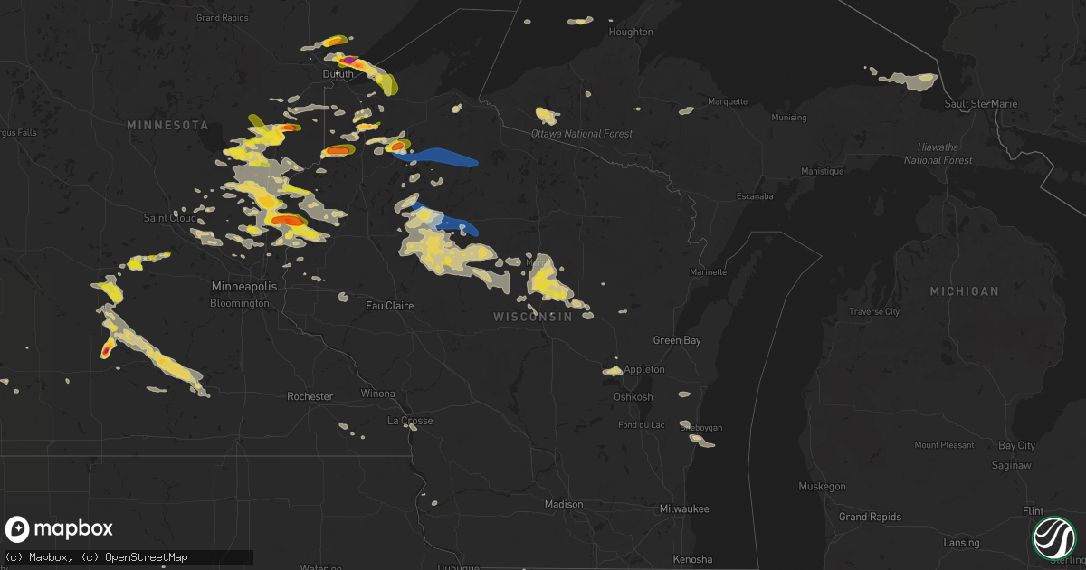
Hail Map on July 27, 2023
Get this storm
July 27 map
$229
one time, instant access
Download today. No call, no setup
Keep the $229
Bought the map and want the full workflow? Apply the entire $229 to a subscription within 7 days. None of it is wasted.
Every map, not just this one
This buys you this map. Subscription and you get every map we run, in the markets you choose from a few cities to whole states to nationwide. Plus real-time alerts the moment a storm fires.
Contact data
Name, contact info, occupancy, even credit band for addresses in the footprint. You go from where it hit to who to call.
Become the source they trust
Unlimited branding weather history reports on demand. You already have the documented answer ready for the property owner, and you are the one who showed up with it.
Property data and RoofTrace estimates
Pull up any address you have got, its value and the exact code rules for that jurisdiction, straight from One Click Code. Then RoofTrace estimates the squares, pitch, and roof value, priced the way you price.
States Impacted by Hail Map on July 27, 2023
Storm reports
West Virginia
| Date | Description |
|---|---|
| 07/27/20235:10 PM CDT | Several trees down along huntington road in gallipolis ferry. |
| 07/27/20232:40 PM CDT | Quarter size hail was reported near shenandoah junction and shepherdstown. |
| 07/27/20232:40 PM CDT | Tree damage was reported near shepherdstown... Including a large tree that blew down on private property along cr-16/1 gardners lane. |
Wyoming
| Date | Description |
|---|---|
| 07/27/20236:44 AM CDT | Mesonet station co128 us 85 wyoming border. |
| 07/26/202311:11 PM CDT | Asos station kcpr casper airport. |
Pennsylvania
| Date | Description |
|---|---|
| 07/27/20235:42 PM CDT | 911 call center relayed a report from a park ranger of a tree down in hickory run state park. Time estimated from radar. |
| 07/27/20235:25 PM CDT | A few trees down in the area of dennison and foster townships. |
| 07/27/20235:20 PM CDT | Wires down reported at wilson road and doe run road in west marlborough township. Time estimated from radar. |
| 07/27/20234:54 PM CDT | Tree fell bringing down power lines and a pole in a nearby alleyway via county dispatch. Time estimated from radar. |
| 07/27/20234:40 PM CDT | Trees and wires down in providence township... Time estimated from radar. |
| 07/27/20234:40 PM CDT | Trees and wires down in pequea township... Time estimated from radar. |
| 07/27/20234:36 PM CDT | Trees down via county dispatch. Time estimated from radar. |
| 07/27/20234:06 PM CDT | High voltage power line down via county dispatch. Time estimated from radar. |
| 07/27/20233:58 PM CDT | Trees down on wires near madison street & monroe street. |
| 07/27/20233:10 PM CDT | Multiple trees down. |
| 07/27/20233:08 PM CDT | Wires down. |
| 07/27/20232:51 PM CDT | Trees down on rush run road. |
Wisconsin
| Date | Description |
|---|---|
| 07/27/20236:56 PM CDT | Social media report with photos of a spruce tree top that had a diameter of approximately 8 inches. Time estimated based on radar. |
| 07/27/20236:34 PM CDT | 2-3 inch diameter branches down. |
| 07/27/20236:25 PM CDT | Several areas in shell lake with trees down across the roadway. Time estimated from radar. |
| 07/27/20236:23 PM CDT | Trees down across roadway. Time estimated from radar. |
| 07/27/20235:55 PM CDT | Delayed report... Time estimated from radar. Several reports of trees and powerlines down with outages near hawkins. |
| 07/27/20235:50 PM CDT | Tree down... Picture via social media. |
| 07/27/20235:34 PM CDT | Storms resulted in trees down and a barn window blown in. Time estimated from radar. |
| 07/27/20235:30 PM CDT | Medium to large poplar trees snapped about 10 feet from the ground. Observe reports gusting swirling trees and 1.4 inches of rain. Time estimated from radar. |
| 07/27/20235:25 PM CDT | Tree down on powerline causing fire. Time estimated via radar. |
| 07/27/20235:20 PM CDT | Fallen medium to large trees blocking an entrance to black lake campground. Time estimated from radar. |
| 07/27/20235:06 PM CDT | Trees down on powerlines between casino and lake road. Time estimated from radar. |
| 07/27/20235:05 PM CDT | Multiple trees and large branches down on county road cc. Some trees down over powerlines causing fires. Time estimated from radar. |
| 07/27/20235:05 PM CDT | 10 inch diameter aspen tree snaped off 6ft off ground. Time estimated by radar. |
| 07/27/20235:01 PM CDT | Aspen tree snapped halfway up. Time estimated from radar. |
| 07/27/20234:55 PM CDT | Trees down over lakeshore dr. |
| 07/27/20234:55 PM CDT | 8 inch diameter 40 foot tall spruce tree snapped at base. Time estimated from radar. |
| 07/27/20234:50 PM CDT | Reports of multiple trees around or less than 1 foot in diameter down along highway 77 between intersection with cty. Hwy oo and forest road 204. Time estimated from ra |
| 07/27/20234:44 PM CDT | Several trees down over roadway. Time estimated from radar. |
| 07/27/20234:35 PM CDT | Amateur radio report of numerous 8-10 inch trees down 10 miles north of st. Croix falls... Wi. Time approximated via radar. |
| 07/27/20234:35 PM CDT | Measured report received from amateur radio. |
| 07/27/20234:34 PM CDT | Many trees down brandt rd making the road impassible. Time estimated from radar. |
| 07/27/20234:30 PM CDT | A local report indicates 1.00 inch wind near 7 E Solon Springs |
| 07/27/20234:30 PM CDT | Reports multiple trees down uprooted and snapped at base. Time estimated from radar. |
| 07/27/20234:30 PM CDT | Video of winds ripping roof partially off. Time estimated from radar. |
| 07/27/20234:30 PM CDT | Trees across roadway. |
| 07/27/20234:21 PM CDT | Numerous small branches and a few wrist size or larger branches down. Time estimated from radar. |
| 07/27/20234:10 PM CDT | Trees over powerlines along county n near drummond. Time estimated from radar. |
| 07/27/20233:59 PM CDT | A local report indicates 1.75 inch wind near 3 NNW Gordon |
| 07/27/20233:47 PM CDT | A local report indicates 1.50 inch wind near 2 S Cozy Corner |
| 07/27/20233:20 PM CDT | Photos on social media of large 3-4 diameter tree snapped halfway up from its base. Time estimated via radar. |
| 07/27/20237:28 AM CDT | Old barn collapsed near county d and hh. Time estimated from radar. |
| 07/26/20239:10 PM CDT | Reports of tree on power line and another tree down per outagamie so dispatch from gust front moving through the immediate area. |
| 07/26/20239:00 PM CDT | Report of tree on power line resulting in loss of power in black creek per outagamie so dispatch from gust front moving through the immediate area. |
| 07/26/20238:00 PM CDT | Social media photo showing estimated hail a quarter in size. |
| 07/26/20237:45 PM CDT | Also strong winds estimated to 70 mph. |
| 07/26/20237:40 PM CDT | A local report indicates 1.25 inch wind near 1 NNW Weston |
| 07/26/20237:38 PM CDT | Several trees down in norwood area. Time estimated from radar. |
| 07/26/20237:30 PM CDT | Several trees down in rolling township. |
| 07/26/20237:30 PM CDT | A local report indicates 1.25 inch wind near 2 NE Wausau |
| 07/26/20237:30 PM CDT | Dime to quarter size hail from social media report photos. |
| 07/26/20237:27 PM CDT | Via social media post. |
| 07/26/20237:25 PM CDT | Report from social media with photos showing a pine tree snapped near the base. Time estimated based on general range from observer and radar. |
| 07/26/20237:25 PM CDT | Social media report with photos. Time estimated based on radar. |
| 07/26/20237:18 PM CDT | Trees and power lines down near the town of schley. Time estimated by radar. |
| 07/26/20237:15 PM CDT | Several trees down near highway 64 and cain creek road. Time estimated from radar. |
| 07/26/20237:07 PM CDT | Tree down at 10th and memorial drive. |
Massachusetts
| Date | Description |
|---|---|
| 07/27/20236:17 PM CDT | Lightning strike do building with damage. Bricks all over mass ave. |
| 07/27/20236:17 PM CDT | Lightning strike to building with damage. Bricks all over mass ave. |
| 07/27/20235:40 PM CDT | Tree down on wires near mechanic street. |
| 07/27/20235:40 PM CDT | Tree down on wires on berwick road in attleborough. |
| 07/27/20235:40 PM CDT | Tree down on wires near mechanic street. Tree down on wires on berwick road. |
| 07/27/20235:39 PM CDT | Tree down on kelley blvd. |
| 07/27/20235:39 PM CDT | Large tree down on power lines on lindsay st at arrowhead circle and bungay road. |
| 07/27/20235:39 PM CDT | Tree down on route 1 south in north attleboro. |
| 07/27/20235:39 PM CDT | Large tree down on power lines on lindsay street at arrowhead circle and bungay road. Tree down on kelley blvd. |
| 07/27/20235:15 PM CDT | Tree down blocking mbta train tracks. |
| 07/27/20234:56 PM CDT | In uxbridge... A tree was down on wires at west river road and hartford avenue. |
| 07/27/20233:55 PM CDT | In charlton... Power lines were down on brookfield road near osgood road. |
| 07/27/20233:44 PM CDT | In belchertown... A tree was down on wires on east street. |
| 07/27/20233:32 PM CDT | In palmer... A tree was down on power lines on maple street at maple terrace. |
| 07/27/20233:15 PM CDT | In springfield... A tree and wires were down in the 100 block of victoria street. Also... A tree was partially down on the roadway on plainfield street. Trees were down |
| 07/27/20233:15 PM CDT | In springfield... A tree and wires were down in the 100 block of victoria street. Also... A tree was partially down on the roadway on plainfield street. Trees were down |
| 07/27/20233:15 PM CDT | In springfield... A tree and wires were down in the 100 block of victoria street. Also... A tree was partially down on the roadway on plainfield street. |
| 07/27/20233:15 PM CDT | In west springfield... Multiple limbs were down on park avenue. |
| 07/27/20233:15 PM CDT | Corrects previous tstm wnd dmg report from 2 nw springfield. In springfield... A tree and wires were down in the 100 block of victoria street. Also... A tree was partia |
| 07/27/20233:12 PM CDT | In chicopee... A tree was down on grattan street. |
| 07/27/20233:12 PM CDT | In chicopee... A tree was down on grattan street. Another tree was down at the intersection of granby road and springfield street. |
| 07/27/20233:12 PM CDT | In westfield... Two trees were down on bates road by belden drive. |
| 07/27/20233:00 PM CDT | In westfield... Numerous trees were down. Two trees down on bates road by belden drive. Single trees reported down on pochassic street... Union street near washington s |
| 07/27/20233:00 PM CDT | In westfield... Numerous trees were down. Two trees down on bates road by belden drive. Single trees reported down on montgomery road... Pochassic street... Union stree |
| 07/27/20233:00 PM CDT | Corrects previous tstm wnd dmg report from 3 w westfield. In westfield... Two trees were down on bates road by belden drive. |
| 07/27/20232:56 PM CDT | Asos station kbaf westfield-barnes ap. |
| 07/27/20232:34 PM CDT | Tree down on canaan southfield road. |
| 07/27/20232:34 PM CDT | Tree down across route 7 northbound... Just north of salisbury ct line. |
| 07/27/20232:16 PM CDT | Tree down on canaan southfield road. |
| 07/27/20232:16 PM CDT | Tree down across route 7 northbound... Just north of salisbury ct line. |
| 07/27/20232:15 PM CDT | Tree down on wires clayton mill rver rd |
Kentucky
| Date | Description |
|---|---|
| 07/26/20239:02 PM CDT | A few trees were downed along river road. Time estimated from radar. |
| 07/26/20238:52 PM CDT | Montgomery county dispatch reported a tree blown down around the intersection of bedford and town branch roads. Time estimated from radar. |
| 07/26/20238:47 PM CDT | Montgomery county dispatch reported a tree blown down onto stepstone rd near the bath/montgomery county line. Time estimated from radar. |
| 07/26/20238:28 PM CDT | Montgomery county dispatch reported a power line blown down in the 7000 block of maysville rd. Time estimated from radar. |
| 07/26/20238:27 PM CDT | Montgomery county dispatch reported several trees blown down onto cecil rd. Time estimated from radar. |
| 07/26/20238:27 PM CDT | A few trees were downed. Time estimated from radar. |
| 07/26/20238:18 PM CDT | Multiple trees and branches down across squiresville road. |
| 07/26/20237:30 PM CDT | Rowan county dispatch reported a tree blown down onto moores flat rd in the 1100 block. Time estimated from radar. |
| 07/26/20237:02 PM CDT | Rowan county dispatch reported a tree blown down along the 1700 block of christy creek. Time estimated by radar. |
Rhode Island
| Date | Description |
|---|---|
| 07/27/20236:59 PM CDT | Tree down on wires on pleasant street. Time estimated from radar. |
| 07/27/20236:45 PM CDT | Tree down on plainfield pike in coventry blocking the entrance to carbuncle pond. |
| 07/27/20236:02 PM CDT | Report from mping: 3-inch tree limbs broken; power poles broken. |
Virginia
| Date | Description |
|---|---|
| 07/27/20235:31 PM CDT | Trees blew down on east frederick drive near maywood terrace/woodstone terrace. |
| 07/27/20235:18 PM CDT | Trees blew down along va-629 cobb house road. |
| 07/27/20235:15 PM CDT | Trees and wires blew down in middleburg. |
| 07/27/20235:15 PM CDT | Photo of multiple trees down in ashburn on gala circle. |
| 07/27/20235:00 PM CDT | Several trees and wires blew down around leesburg. |
| 07/27/20234:42 PM CDT | Trees blew down near the intersection of va-765 ridgeside road and va-626 foggy bottom road. |
| 07/27/20234:34 PM CDT | Trees blew down on us-15 james monroe highway/monroe-madison memorial highway between va-651 hogback mountain road and va-704 harmony church road. |
| 07/27/20234:34 PM CDT | Multiple trees down on locks mill road along the shenandoah river. |
| 07/27/20234:29 PM CDT | Trees blew down near the intersection of va-848 holmes mill road and va-704 harmony church road. |
| 07/27/20234:17 PM CDT | A wind gust of 60 knots |
| 07/27/20234:14 PM CDT | Several trees blew down in the city of winchester. |
| 07/27/20233:48 PM CDT | Trees blew down near the intersection of va-694 john wolford road/the narrows road and va-681 milltown road. |
| 07/27/20233:48 PM CDT | Trees blew down near the intersection of va-681 milltown road and va-682 rodeffer road. |
Idaho
| Date | Description |
|---|---|
| 07/27/20235:45 PM CDT | Photo submitted from south of soda springs along the caribou/bear lake co. Line. Time estimated by radar. |
Connecticut
| Date | Description |
|---|---|
| 07/27/20236:58 PM CDT | Report from mping: 3-inch tree limbs broken; power poles broken. |
| 07/27/20236:40 PM CDT | Tree limbs down causing power outages. |
| 07/27/20236:38 PM CDT | Tree limbs down causing power outages. |
| 07/27/20236:06 PM CDT | Tree limbs down causing power outages. |
| 07/27/20235:32 PM CDT | In columbia... A tree and wires were down on route 87 and a tree and wires were down on lake road. |
| 07/27/20235:31 PM CDT | 1-inch tree limbs broken; shingles blown off. |
| 07/27/20235:30 PM CDT | Tree down on wires on erdoni road in columbia. Tree down on wires on thompson hill rd in columbia. Tree and wires were down on route 87 and lake road. Tree down on old |
| 07/27/20235:30 PM CDT | Tree down on wires on erdoni rd in columbia. Relayed by amateur radio. |
| 07/27/20235:30 PM CDT | Tree down on old willimantic rd. Relayed by amateur radio. |
| 07/27/20235:23 PM CDT | Tree limbs down causing power outages. |
| 07/27/20235:14 PM CDT | Tree limbs down causing power outages. |
| 07/27/20235:12 PM CDT | Sandy hook fire dept confirms fallen tree and wires on riverside rd. Time estimated by radar. |
| 07/27/20235:09 PM CDT | Several branches larger than 3 inches in diameter blown off trees. Estimated wind gusts between 50 and 60mph.reported by trained spotter. |
| 07/27/20235:00 PM CDT | 2 inch diameter tree limbed snapped from the top of a tree down on jonathan trumbull highway. |
| 07/27/20235:00 PM CDT | In pomfret... A tree was down on wires on taft pond road. Another tree was down on wires on wrights crossing road. |
| 07/27/20234:50 PM CDT | Tree down on pilfershire and weeks road. |
| 07/27/20234:50 PM CDT | Tree down on pilfershire and weeks road. Tree down on north road in ashford. |
| 07/27/20234:50 PM CDT | In north windham... A tree was reported to be down on a mobile home... Street not specified. |
| 07/27/20234:40 PM CDT | Tree down on north road in ashford. Relayed by amateur radio. |
| 07/27/20234:25 PM CDT | In farmington... Wires were downed on route 4 |
| 07/27/20234:25 PM CDT | In south windsor... Power lines were down on the 100 block of oak street. |
| 07/27/20234:20 PM CDT | In west hartford... A tree was down on wires and a utility pole was snapped. |
| 07/27/20234:00 PM CDT | In simsbury... A tree was down on corey road. |
| 07/27/20233:42 PM CDT | Tree down blocking one lane of torringford st |
| 07/27/20233:38 PM CDT | Large tree down across riverside ave |
| 07/27/20233:05 PM CDT | Trees and wires down moses mead rd |
| 07/26/20238:36 PM CDT | Tree down on wires on thompson hill rd in columbia. Relayed by amateur radio. |
Alabama
| Date | Description |
|---|---|
| 07/27/20235:15 PM CDT | Several trees blown down with some large branches broken. The roof was blown off of a metal building structure. Possible microburst. |
Arizona
| Date | Description |
|---|---|
| 07/27/20236:30 PM CDT | Approximately 9 tractor trailer rigs were blown over and/or jackknifed along i-10 near vicksburg rd. This occurred at two to three locations from milepost 41 to milepos |
| 07/27/20236:15 PM CDT | Corrects previous non-tstm wnd gst report from 3 sse patagonia. Mesonet station gw3161 patagonia. |
| 07/27/202312:19 AM CDT | Mesonet station qhpa3 hopkins. |
| 07/26/202311:25 PM CDT | Corrects previous tstm wnd gst report from 12 nw patagonia. Mesonet station qhpa3 hopkins. |
| 07/26/202311:19 PM CDT | Mesonet station qhpa3 hopkins. |
| 07/26/202310:25 PM CDT | Mesonet station cw8733 tucson snyder/soldier trail. |
Minnesota
| Date | Description |
|---|---|
| 07/27/20235:40 PM CDT | Quarter sized hail measured 2 miles south of franklin... Mn. Photo provided via social media. Time estimated via radar. |
| 07/27/20235:20 PM CDT | Mix of hail from pea sized to one inch diameter lasted for several minutes. |
| 07/27/20235:15 PM CDT | Report sent via facebook. |
| 07/27/20235:15 PM CDT | Trained spotter reported quarter sized hail in morgan... Mn. Time estimated via radar. |
| 07/27/20235:10 PM CDT | Phoned in report. Mostly quarter size hail but one half dollar size hail stone observed. |
| 07/27/20235:10 PM CDT | Corrects previous hail report from morgan. Trained spotter measured quarter sized hail in the town of morgan... Mn. Time estimated via radar. |
| 07/27/20235:01 PM CDT | Corrects previous hail report from 3 w hinckley. |
| 07/27/20234:55 PM CDT | A local report indicates 1.00 inch wind near 3 W Hinckley |
| 07/27/20234:45 PM CDT | Heavy rain causing surface runoff and minor flooding. |
| 07/27/20234:34 PM CDT | Report from mping: ping pong ball |
| 07/27/20234:20 PM CDT | Half to one inch hail. |
| 07/27/20233:53 PM CDT | A local report indicates 1.50 inch wind near 4 NE Rice Lake |
| 07/27/20233:51 PM CDT | Trained spotter reported numerous 8 to 10-inch diameter trees down across roadways and powerlines down. Time estimated via radar. |
| 07/27/20233:45 PM CDT | Report of several trees down 2 miles ese of rush city... Mn. Time estimated via radar. |
| 07/27/20233:44 PM CDT | A local report indicates 1.75 inch wind near 3 NNE Lester Park |
| 07/27/20233:40 PM CDT | Via social media. |
| 07/27/20233:40 PM CDT | Quarter sized hail reported 3 miles ne of rush city... Mn. Photo provided social media. |
| 07/27/20233:37 PM CDT | Also had trees down in the area. |
| 07/27/20233:36 PM CDT | Report from mping: ping pong ball |
| 07/27/20233:35 PM CDT | Several medium trees snapped at base and fell over powerlines. Time estimated from radar. |
| 07/27/20233:35 PM CDT | Corrects previous tstm wnd dmg report from 1 sw french river. Several trees were bent or snapped halfway up near the railroad tracks at mcquade road. Time estimated by |
| 07/27/20233:35 PM CDT | A local report indicates 2.00 inch wind near 3 W French River |
| 07/27/20233:35 PM CDT | A local report indicates 1.00 inch wind near 1 SE Lester Park |
| 07/27/20233:33 PM CDT | A local report indicates 1.00 inch wind near 2 W Lester Park |
| 07/27/20233:30 PM CDT | A local report indicates 2.00 inch wind near 3 N Lester Park |
| 07/27/20233:30 PM CDT | A local report indicates 1.00 inch wind near 5 SE Arthyde |
| 07/27/20233:30 PM CDT | Mature maple tree of around a 10 inch diameter down on northeast corner of umd. Time estimated by radar. This corrects an earlier report that relayed a 10 inch radius m |
| 07/27/20233:25 PM CDT | A local report indicates 2.00 inch wind near 3 N Lester Park |
| 07/27/20233:25 PM CDT | Corrects previous hail report from 4 ne rice lake. |
| 07/27/20233:18 PM CDT | Some trees were snapped halfway up near the railroad tracks at mcquade road. Time estimated by radar. |
| 07/27/20233:15 PM CDT | Cocorahs station mn-sl-232. |
| 07/27/202311:40 AM CDT | Report from mping: 3-inch tree limbs broken with time estimated based on radar. |
| 07/27/20237:00 AM CDT | Delayed report... Time esimated from radar. Hail quarter to golfball in almelund... With some vehicle damage reported. |
| 07/27/202312:38 AM CDT | 10 inch diameter tree limb blocking roadway. Delayed report via law enforcement. Time estimated by radar. |
| 07/27/202312:20 AM CDT | Several reports of branches down across mankato courtesy of keyc and social media. |
| 07/27/202312:20 AM CDT | Delayed report... Time estimated from radar. Trees and large branches down in skyline. |
| 07/27/202312:20 AM CDT | Delayed report... Time estimated from radar. Picture of large branch down at lions lake park courtesy of keyc and social media. |
| 07/27/202312:10 AM CDT | Delayed report... Time estimated from radar. Picture of large branch down at spring lake park courtesy of keyc and social media. |
| 07/26/202311:40 PM CDT | Correct for time. Report from mping: 3-inch tree limbs broken with time estimated based on radar. |
| 07/26/202311:40 PM CDT | Delayed report... Time esimated from radar. Large pine tree partially uprooted. |
| 07/26/202311:30 PM CDT | Delayed report... Time estimated from radar. Lots of trees down and corn flattened along a line from lafayette to north mankato. |
| 07/26/20239:30 PM CDT | Emergency management reported quarter size hail in the city of lake lillian... Mn. |
| 07/26/20238:50 PM CDT | Report from mping: quarter |
| 07/26/20237:30 PM CDT | Delayed report via facebook... Mix of quarter to half dollar sized hail. |
| 07/26/20237:15 PM CDT | Report received via amateur radio along co rd. 16 two miles north of taylors falls... Mn. |
| 07/26/20237:12 PM CDT | Most of the hail was nickel size. |
| 07/26/20237:00 PM CDT | Estimated 4 inches of rainfall. |
Ohio
| Date | Description |
|---|---|
| 07/27/20235:15 PM CDT | Trees down on cars. |
| 07/27/20235:08 PM CDT | Wires knocked down. Time estimated from radar. |
| 07/27/20235:06 PM CDT | Trees and wires knocked down onto car. Time estimated from radar. |
| 07/27/20234:55 PM CDT | Gallia county 911 center advised they have reports of multiple trees down along plas road in raccoon township. Time estimated from radar. |
| 07/27/20234:55 PM CDT | Gallia county 911 center advised they have reports of multiple trees down along plas road in raccoon township. Time estimated from radar. |
| 07/27/20233:18 PM CDT | Morrow-blackhawk road closed due to downed trees. Time estimated from radar. |
| 07/26/20239:36 PM CDT | 2-3 inch diameter healthy tree limb down. |
| 07/26/20239:09 PM CDT | Downed tree limbs... Approx. 3 inches in diameter... Over werk road. |
Michigan
| Date | Description |
|---|---|
| 07/27/20236:50 PM CDT | U.s. Forest service reports multiple trees and large branches downed of a wide variety of tree types scattered throughout the sylvania wilderness area in eastern gogebi |
| 07/27/20236:41 PM CDT | Ontonagon county dispatch reports a few trees of unknown size down on power lines in ewen. |
| 07/27/20236:19 PM CDT | Corrects time of previous tstm wnd dmg report from ewen. Ontonagon county dispatch reports a few trees of unknown size down on power lines in ewen. |
| 07/27/20235:17 AM CDT | Large branches down on glendora road... North of reed road. |
| 07/26/20239:00 PM CDT | Report from social media includes description of damage and image. Observer came home and found large storage shed/carport thrown and wrapped around trees. Frame is des |
| 07/26/20238:46 PM CDT | Marquette county central dispatch reports trees and power lines downed along reservoir street and quarry road in harvey. |
| 07/26/20238:36 PM CDT | Marquette county central dispatch reports downed tree on a vehicle on altamont street in marquette. |
| 07/26/20238:10 PM CDT | Large maple tree limb downed in south marquette. Delayed report via social media. Estimated wind gusts of 40 to 50 mph. |
| 07/26/20238:07 PM CDT | Marquette county central dispatch reports trees down and power lines downed on wilkinson street in north marquette. |
| 07/26/20237:56 PM CDT | Corrects time of previous tstm wnd dmg report from 1 wnw harvey. Marquette county central dispatch reports trees and power lines downed along reservoir street and quarr |
| 07/26/20237:54 PM CDT | Corrects time of previous tstm wnd dmg report from 1 n marquette. Marquette county central dispatch reports trees down and power lines downed on wilkinson street in nor |
| 07/26/20237:54 PM CDT | Marquette county central dispatch reports a tree on power lines off midway drive in negaunee township. Max wind gust at wfo was 47 mph just a few minutes previous to th |
| 07/26/20237:54 PM CDT | Corrects time of previous tstm wnd dmg report from 1 ssw marquette. Marquette county central dispatch reports downed tree on a vehicle on altamont street in marquette. |
| 07/26/20237:45 PM CDT | Observed a large diameter maple tree snapped around 5 feet above the trunk in tilden township along marquette county road 581. Section of tree landed in a driveway. Tim |
| 07/26/20237:15 PM CDT | U.s. Forest service reports multiple trees and large branches downed of maple and fir trees along crystal lake road and birch lake roads in eastern gogebic county just |
New Hampshire
| Date | Description |
|---|---|
| 07/27/20233:28 PM CDT | Tree down on rattlesnake hill road. |
| 07/27/20233:10 PM CDT | Tree down partially blocking huse rd in the area of parkview condominiums dr. Time estimated by radar. |
| 07/27/20233:10 PM CDT | Large tree down partially blocking south mammoth street near the underpass. Time estimated by radar. |
| 07/27/20233:04 PM CDT | Delayed report: reported by amateur radio. Trees down on spofford road. Time estimated by radar. |
| 07/27/20233:02 PM CDT | Tree down on county road. |
| 07/27/20232:53 PM CDT | Delayed report: trees down near sheffield woods by jenkins road. Time estimated by radar. |
| 07/27/20232:15 PM CDT | 1 inch hail observed falling for 4-5 mins. |
| 07/27/20232:10 PM CDT | Tree and wires down on cobb meadow rd. |
| 07/27/20232:02 PM CDT | Reported by weather spotter. Quarter size hail reported in marlborough. Time estimated by radar. |
| 07/27/20232:00 PM CDT | Trees and wires down on merrymen rd. |
| 07/27/20232:00 PM CDT | Large tree down across main street. Road is closed. Time estimated by radar. |
| 07/27/20232:00 PM CDT | Multiple trees down on dublin rd. Road is closed. |
| 07/27/20231:54 PM CDT | Spotter reported a funnel cloud reaching the ground with rapid rotation. |
| 07/27/20231:50 PM CDT | Large tree down on base hill rd. Time estimated by radar. |
South Dakota
| Date | Description |
|---|---|
| 07/27/20235:50 PM CDT | A local report indicates 66 MPH wind near 12 E Oelrichs |
| 07/26/20239:00 PM CDT | A local report indicates 60 MPH wind near 1 SW Wood |
| 07/26/20239:00 PM CDT | A local report indicates 1.00 inch wind near 1 SW Wood |
| 07/26/20238:56 PM CDT | Wind gusts of 40 to 60 mph. Radar estimated time. |
| 07/26/20238:28 PM CDT | A local report indicates 60 MPH wind near 6 W Parmelee |
| 07/26/20238:01 PM CDT | A local report indicates 59 MPH wind near 9 ENE Belvidere |
| 07/26/20238:00 PM CDT | A local report indicates 1.75 inch wind near 4 NNE Bunker |
| 07/26/20237:51 PM CDT | A local report indicates 61 MPH wind near 9 ENE Belvidere |
| 07/26/20237:41 PM CDT | A local report indicates 61 MPH wind near 5 NE Porcupine |
| 07/26/20237:31 PM CDT | A local report indicates 58 MPH wind near 4 E Cactus Flat |
| 07/26/20237:21 PM CDT | A local report indicates 61 MPH wind near 4 E Cactus Flat |
Indiana
| Date | Description |
|---|---|
| 07/27/20235:21 AM CDT | Photo shared via social media shows a 2 to 4 inch diameter tree branch that had been snapped near oak st and garfield st. |
Illinois
| Date | Description |
|---|---|
| 07/27/20235:18 AM CDT | A local report indicates 75 MPH wind near 2 SSW Milford |
| 07/27/20235:10 AM CDT | Corrects time of previous tstm wnd gst report from 2 ssw milford. |
| 07/27/20233:48 AM CDT | Large tree branch broken off as well as a flag pole knocked over. Time estimated by radar and time of report. |
| 07/27/20233:48 AM CDT | Large tree branch broken off as well as a flag pole knocked over |
| 07/27/20233:46 AM CDT | Tree damage from a 1-1.5 foot diameter tree. Time estimated by radar. |
| 07/27/20233:22 AM CDT | Kendall county sheriff reported a tree approximately 22 inches in diameter had snapped at the trunk. This occurred near the intersection of harve and charles streets in |
| 07/27/20233:15 AM CDT | A local report indicates 73 MPH wind near Polo |
| 07/27/20232:45 AM CDT | A local report indicates 64 MPH wind near 4 S Compton |
| 07/27/20232:24 AM CDT | Lee county sheriffs office reports tree damage across lee county with the worst in dixon and ashton. Time estimated by radar. |
| 07/27/20232:17 AM CDT | Measured via anemometer. |
| 07/27/20231:45 AM CDT | Large tree broken off near the base. Also another tree fell over and blocked the road at a nearby cemetery and took out power lines. |
Florida
| Date | Description |
|---|---|
| 07/26/20238:00 PM CDT | [waterspout] south of hollywood blvd & 16th ave. Water rising into peoples homes. |
Maryland
| Date | Description |
|---|---|
| 07/27/20234:25 PM CDT | Md-117 bucklodge road was closed in both directions due to downed trees near md-28 darnestown road. |
| 07/27/20234:11 PM CDT | Several trees and wires blew down near dickerson... Including near the intersection of md-28 dickerson road and martinsburg road. |
New York
| Date | Description |
|---|---|
| 07/27/20234:51 PM CDT | Dot reports tree down on ny 129 eastbound at saw mill river road... Lanes blocked. Time estimated by radar. |
| 07/27/20234:38 PM CDT | Tree and wires down on quaker rd and evans ave. |
| 07/27/20234:35 PM CDT | Many poles... Trees and wires down in the beekman area. One tree down on a shed. |
| 07/27/20234:30 PM CDT | Route 82 closed in both directions due to downed trees and wires. Wires down on a couple of occuppied vechiles. |
| 07/27/20234:19 PM CDT | Trees and wires down blocking ridge rd. Time estimated from radar. |
| 07/27/20234:15 PM CDT | Tree down on salk dr. Time estimated from radar. |
| 07/27/20234:15 PM CDT | Tree on road near mile hill rd/ransom rd. Time estimated from radar. |
| 07/27/20234:15 PM CDT | Roue 44 closed at townsend blvd due to tree down on wires. |
| 07/27/20234:15 PM CDT | Tree on road near river rd/bellevue rd. Time estimated from radar. |
| 07/27/20234:12 PM CDT | Wires down near vineyard ave/reservoir rd. Time estimated from radar. |
| 07/27/20234:12 PM CDT | Tree down on commercial ave ext. Time estimated from radar. |
| 07/27/20234:12 PM CDT | Tree down in road near christopher ave/bell dr. Time estimated from radar. |
| 07/27/20234:05 PM CDT | Wires down on jenkinstown rd. Time estimated from radar. |
| 07/27/20234:04 PM CDT | Tree down on n chestnut st. Time estimated from radar. |
| 07/27/20234:04 PM CDT | Tree in road near rt 32/dubois rd. Time estimated from radar. |
| 07/27/20234:00 PM CDT | Tree in road near mohonk ave/fairview ave. Time estimated from radar. |
| 07/27/20233:56 PM CDT | Tree down on n chodikee lake rd. Time estimated from radar. |
| 07/27/20233:36 PM CDT | Trees and wires burning on property via county dispatch. Time estimated from radar. |
| 07/27/20233:18 PM CDT | Trees and wires down via county dispatch. Time estimated from radar. |
| 07/27/20232:42 PM CDT | Tree down on dewitt lake rd. Time estimated from radar. |
| 07/27/20232:35 PM CDT | Tree in road near rt 28/zena rd. Time estimated from radar. |
| 07/27/20232:30 PM CDT | Trees and wires burning via county dispatch. Time estimated from radar. |
| 07/27/20232:24 PM CDT | Tree in road near frank sottile blvd/ulster ave. Time estimated from radar. |
| 07/27/20232:19 PM CDT | Tree down on rt 28a. Time estimated from radar. |
| 07/27/20232:16 PM CDT | Tree down on watson hollow rd. Time estimated from radar. |
| 07/27/20232:13 PM CDT | Trees and wires down on road via county dispatch. Time estimated from radar. |
| 07/27/20231:58 PM CDT | Wires down on cooper st. Time estimated from radar. |
| 07/27/20231:48 PM CDT | Wires down on backman ave. Time estimated from radar. |
| 07/27/20231:45 PM CDT | Wires down on ridgewood ave. Time estimated from radar. |
| 07/27/20231:43 PM CDT | Tree down on wires |
| 07/27/20231:33 PM CDT | Wires down on high point mountain rd. Time estimated from radar. |
Cities Impacted by Hail Map on July 27, 2023
- Mass City, MI
- Hayward, WI
- Breda, IA
- Marenisco, MI
- Saint Croix Falls, WI
- Centuria, WI
- Jefferson, IA
- Grand Junction, IA
- Wall Lake, IA
- Minong, WI
- Gordon, WI
- Perry, IA
- Rippey, IA
- Ogden, IA
- Balsam Lake, WI
- Amery, WI
- Jeffersonville, IN
- Prospect, KY
- Fort Dodge, IA
- Keene, NH
- Swanzey, NH
- Marlborough, NH
- Harrisville, NH
- Dublin, NH
- Peterborough, NH
- Granville, MA
- Sandisfield, MA
- East Otis, MA
- Otis, MA
- Blandford, MA
- Russell, MA
- Southwick, MA
- Feeding Hills, MA
- Westfield, MA
- West Springfield, MA
- Chicopee, MA
- Southampton, MA
- Holyoke, MA
- Indian Orchard, MA
- Springfield, MA
- Ludlow, MA
- South Hadley, MA
- Belchertown, MA
- Wilbraham, MA
- Granby, MA
- Bondsville, MA
- Three Rivers, MA
- Palmer, MA
- Monson, MA
- Thorndike, MA
- Ware, MA
- Brimfield, MA
- West Warren, MA
- Warren, MA
- West Brookfield, MA
- Duluth, MN
- Sturgeon Lake, MN
- McGrath, MN
- Mcgregor, MN
- Finlayson, MN
- Willow River, MN
- Solon Springs, WI
- Cable, WI
- Harris, MN
- North Branch, MN
- Sandstone, MN
- Askov, MN
- Isle, MN
- Agawam, MA
- East Longmeadow, MA
- Longmeadow, MA
- Hampden, MA
- Taylors Falls, MN
- Grantsburg, WI
- Center City, MN
- Lindstrom, MN
- Cushing, WI
- Brule, WI
- Port Wing, WI
- Maple, WI
- Iron River, WI
- Luck, WI
- Danbury, WI
- Rush City, MN
- Milltown, WI
- Bruno, MN
- Kerrick, MN
- Brook Park, MN
- Hinckley, MN
- Mora, MN
- Morgan, MN
- Grace, ID
- Exeland, WI
- Ladysmith, WI
- Tony, WI
- Glen Flora, WI
- Hawkins, WI
- Glidden, WI
- Butternut, WI
- Soda Springs, ID
- Ogema, WI
- Kennan, WI
- Catawba, WI
- Siren, WI
- Franklin, MN
- Fairfax, MN
- Hector, MN
- Carlton, MN
- Barnum, MN
- Couderay, WI
- Boulder, WY
- Auburn, WY
- Grover, WY
- Avon, MT
- Garrison, MT
- Saginaw, MN
- Bancroft, ID
- Fairfield, OH
- Foxboro, WI
- Foreston, MN
- Foley, MN
- Charles Town, WV
- Braham, MN
- Pine City, MN
- Elizaville, NY
- Walsenburg, CO
- Butte, MT
- Boulder, MT
- Lake Nebagamon, WI
- Winchester, VA
- Superior, WI
- Mud Butte, SD
- Shenandoah Junction, WV
- Shepherdstown, WV
- Sharpsburg, MD
- Kearneysville, WV
- Harpers Ferry, WV
- Anaconda, MT
- Keedysville, MD
- Rohrersville, MD
- Knoxville, MD
- Kettle River, MN
- Wahkon, MN
- Clements, MN
- Grasston, MN
- Ogilvie, MN
- Gallipolis, OH
- Bidwell, OH
- Cheshire, OH
- West Chester, OH
- Tallmansville, WV
- Greencastle, IN
- Drummond, WI
- Alborn, MN
- Canyon, MN
- Frederic, WI
- Webster, WI
- Lander, WY
- Moose Lake, MN
- Somers, CT
- Stafford Springs, CT
- Bainbridge, IN
- Mobile, AL
- Penrose, CO
- Wrenshall, MN
- Waterford, VA
- Lovettsville, VA
- Purcellville, VA
- Paeonian Springs, VA
- Dickerson, MD
- Leesburg, VA
- Cincinnati, OH
- High Bridge, WI
- Woodward, IA
- Faith, SD
- Marysville, MT
- Ojibwa, WI
- Loxley, AL
- Oak Hill, OH
- Point Pleasant, WV
- Stapleton, AL
- Shafer, MN
- Trinidad, CO
- Carlisle, KY
- Salome, AZ
- Stanchfield, MN
- Rock Springs, WY
- Buckhannon, WV
- Vinton, OH
- Philipsburg, MT
- Downey, ID
- Morrow, OH
- Loveland, OH
- Goshen, OH
- South Lebanon, OH
- Maineville, OH
- Dresser, WI
- Lava Hot Springs, ID
- Strasburg, IL
- Windsor, IL
- Kim, CO
- Round Hill, VA
- Berryville, VA
- Ellamore, WV
- Thurman, OH
- York, PA
- Wrightsville, PA
- Wausau, WI
- Merrill, WI
- Gilman, WI
- Isanti, MN
- Stacy, MN
- Watkins, MN
- Litchfield, MN
- Kimball, MN
- Annandale, MN
- South Haven, MN
- Grove City, MN
- Schofield, WI
- Ringle, WI
- Hatley, WI
- Cochise, AZ
- Dragoon, AZ
- Benson, AZ
- Hayes, SD
- Fort Pierre, SD
- Dupree, SD
- Eagle Butte, SD
- White River, SD
- Wood, SD
- Blomkest, MN
- Lake Lillian, MN
- Bird Island, MN
- Olivia, MN
- Bruce, SD
- White, SD
- Brookings, SD
- Aurora, SD
- Wallingford, KY
- Flemingsburg, KY
- Hillsboro, KY
- Mount Olivet, KY
- Brooksville, KY
- Milaca, MN
- Riverton, WY
- Medford, WI
- Rib Lake, WI
- Anniston, AL
- Kadoka, SD
- Philip, SD
- Belvidere, SD
- Cambridge, MN
- Bethel, MN
- Waverly, OH
- Poca, WV
- Charleston, WV
- Athens, WI
- Marshall, MN
- Forest Lake, MN
- Ringling, MT
- South Salem, OH
- Winchester, OH
- West Union, OH
- Whitehall, MT
- Willcox, AZ
- Trilla, IL
- Lerna, IL
- Winter, WI
- Patriot, OH
- Kentwood, LA
- Mosinee, WI
- Dassel, MN
- Weyerhaeuser, WI
- Pinedale, WY
- Conrath, WI
- Sheldon, WI
- Holcombe, WI
- Midland, SD
- Okaton, SD
- Marathon, WI
- Danville, PA
- Wheelersburg, OH
- Franklin Furnace, OH
- Bluemont, VA
- Radisson, WI
- Cynthiana, KY
- Toston, MT
- Roscoe, MT
- Roberts, MT
- Red Lodge, MT
- Brokaw, WI
- Owingsville, KY
- Sharpsburg, KY
- Morehead, KY
- Paris, KY
- Mount Sterling, KY
- Salt Lick, KY
- Looneyville, WV
- Owenton, KY
- Cherry Creek, SD
- Walton, WV
- Reedy, WV
- Elkview, WV
- Spencer, WV
- Gandeeville, WV
- Gay, WV
- Advent, WV
- Kenna, WV
- Lancaster, PA
- Washington Boro, PA
- Columbia, PA
- Ripley, WV
- Evans, WV
- Saint David, AZ
- Becker, MN
- Big Lake, MN
- Atwater, MN
- Mountain Top, PA
- Corinth, KY
- Murdo, SD
- Draper, SD
- Rock River, WY
- Cheyenne, WY
- Absarokee, MT
- Fishtail, MT
- Joliet, MT
- Columbus, MT
- Aniwa, WI
- Birnamwood, WI
- Bruce, WI
- Pleasureville, KY
- Bethlehem, KY
- Lockport, KY
- Campbellsburg, KY
- Comstock, WI
- Daniel, WY
- Big Piney, WY
- Patagonia, AZ
- Princeton, MN
- Moorefield, KY
- Ewing, KY
- Jackson, OH
- Eland, WI
- Wittenberg, WI
- Oak Park, MN
- Wyoming, MN
- Elk River, MN
- Cedar, MN
- Saint Francis, MN
- Anoka, MN
- Andover, MN
- Zimmerman, MN
- Warm Springs, MT
- Moatsville, WV
- Osceola, WI
- Conner, MT
- Gallipolis Ferry, WV
- Henderson, WV
- Sauk Rapids, MN
- Somerset, WI
- New Richmond, WI
- Star Prairie, WI
- Cumberland, WI
- Birchwood, WI
- Bridger, MT
- Lodge Grass, MT
- Lumberport, WV
- Leon, WV
- Thorp, WI
- Lublin, WI
- New Auburn, WI
- Boyd, WI
- Stanley, WI
- Westboro, WI
- Cornell, WI
- Withee, WI
- Thayne, WY
- Millersville, PA
- Laramie, WY
- Sula, MT
- Ellington, CT
- Tolland, CT
- Eminence, KY
- Elliston, MT
- Clear Lake, MN
- Holyoke, MN
- Grover, CO
- Chisago City, MN
- Owen, WI
- Frankfort, KY
- Dalbo, MN
- Poplar, WI
- Connersville, IN
- Brookville, IN
- Chillicothe, OH
- Tigerton, WI
- Pryor, MT
- Blue Creek, OH
- Champion, MI
- Barronett, WI
- Arnoldsburg, WV
- Edgar, WI
- French Creek, WV
- Cosmos, MN
- Wellington, AL
- Ohatchee, AL
- Ashton, WV
- Glenwood, WV
- Isabel, SD
- Georgetown, KY
- Sadieville, KY
- Rothschild, WI
- Willington, CT
- Liberty, WV
- Mattoon, IL
- Stetsonville, WI
- Southside, WV
- Covington, MI
- Saint Cloud, MN
- Lucasville, OH
- McDermott, OH
- Rock Cave, WV
- Crawford, WV
- Cleveland, WV
- Henriette, MN
- Turtle Lake, WI
- Grandy, MN
- Portsmouth, OH
- Eastford, CT
- Ashford, CT
- Stewardson, IL
- Boyce, VA
- Apple Grove, WV
- Crown City, OH
- South Shore, KY
- Greenup, KY
- Raymond, MN
- Willmar, MN
- Onamia, MN
- Daphne, AL
- Berry, KY
- Gibbon, MN
- Timber Lake, SD
- Grantsville, WV
- Elkton, SD
- Flandreau, SD
- Parker City, IN
- Selma, IN
- Mankato, MN
- Woodstock, MN
- Shelbyville, IN
- Stillwater, MN
- Janesville, MN
- Waseca, MN
- Pemberton, MN
- New Ulm, MN
- Nicollet, MN
- Fountain, MN
- Newberry, MI
- Paradise, MI
- Townsend, MT
- Garden City, MN
- Lake Crystal, MN
- Madelia, MN
- Cedar Grove, IN
- West Harrison, IN
- Hamilton, OH
- Okeana, OH
- Oxford, OH
- Gridley, IL
- El Paso, IL
- Chenoa, IL
- Rio Rico, AZ
- Tumacacori, AZ
- Tubac, AZ
- Malone, WI
- Lanesboro, MN
- Ruthton, MN
- Holland, MN
- Harrison, OH
- Valders, WI
- Elgin, AZ
- Shawano, WI
- Oostburg, WI
- Sheboygan, WI
- Sheboygan Falls, WI
- Sault Sainte Marie, MI
- Hasty, CO
- Walnut, IL
- Dorchester, WI
- Curtiss, WI
- Abbotsford, WI
- Woodville, WI
- Hammond, WI
- Baldwin, WI
- Fremont, WI
- Larsen, WI
- Winthrop, MN
- Lafayette, MN
- Madison Lake, MN
- Saint Peter, MN
- Courtland, MN
- Kasota, MN
- Chilton, WI
- Kiel, WI
- La Crosse, WI
- Coon Valley, WI
- Stoddard, WI
- Turners Station, KY
- Colby, WI
- Menomonie, WI
- Walnut Grove, MN
- Revere, MN
- Hokah, MN
- La Crescent, MN
- Winfield, WV
- Eagle Lake, MN
- Sleepy Eye, MN
- College Corner, OH
- Metamora, IN
- Williamstown, KY
- Batesville, IN
- Pleasant Plain, OH
- Knapp, WI
- Lafayette, AL
- Plymouth, WI
- Millersburg, KY
- Olympia, KY
- Aitkin, MN
- Mount Carroll, IL
- Peterson, MN
- Dixon, IL
- Covington, IN
- Perrysville, IN
- Kent, IL
- Stockton, IL
- Gary, IN
- Prairie Du Chien, WI
- Wauzeka, WI
- Ashton, IL
- West Brooklyn, IL
- Amboy, IL
- Ohio, IL
- Sublette, IL
- Greensburg, IN
- Lafayette, IN
- Westpoint, IN
- Hillsdale, NY
- Lebanon, IN
- Thorntown, IN
- Newman, IL
- Hume, IL
- Hebron, IN
- Buckley, IL
- Onarga, IL
- Milford, IL
- Cissna Park, IL
- Attica, IN
- Winamac, IN
- Francesville, IN
- Crown Point, IN
- New England, ND
- Preston, MN
- Medora, ND
- Cassopolis, MI
- Hilbert, WI
- Stockbridge, WI
- Seymour, WI
- Towanda, IL
- Lexington, IL
- Merrillville, IN
- Hobart, IN
- Berrien Springs, MI
- Baroda, MI
- Lanark, IL
- Berrien Center, MI
- Dowagiac, MI
- North Judson, IN
- San Pierre, IN
- Franklin Grove, IL
- Woodstock, CT
- Lyndon, IL
- Erie, IL
- Prophetstown, IL
- Rock Falls, IL
- Forreston, IL
- Polo, IL
- Baileyville, IL
- Freeport, IL
- Shannon, IL
- Hoopeston, IL
- Williamsport, IN
- Rossville, IL
- Rushville, IN
- Milroy, IN
- Bloomington, IL
- Normal, IL
- Sterling, IL
- Laurel, IN
- Pipestone, MN
- Reedsville, WI
- Manitowoc, WI
- Morrison, IL
- Mendota, IL
- Utica, IL
- Earlville, IL
- Oldenburg, IN
- Weyauwega, WI
- Hortonville, WI
- Embarrass, WI
- Clintonville, WI
- Lake Benton, MN
- Sabula, IA
- Pearl City, IL
- Valparaiso, IN
- Volga, SD
- Portage, IN
- Schererville, IN
- Highland, IN
- Lake Station, IN
- Griffith, IN
- Wellington, IL
- Thawville, IL
- Savanna, IL
- Thomson, IL
- Union Mills, IN
- Lena, IL
- Winslow, IL
- Lake Norden, SD
- Antigo, WI
- Chadwick, IL
- Milledgeville, IL
- Hartford, MI
- New Bedford, IL
- Deer Grove, IL
- Princeton, IL
- Sheffield, IL
- Tampico, IL
- Eastman, WI
- Elkhart, IN
- Kouts, IN
- Goshen, IN
- Bristol, IN
- Middlebury, IN
- Manilla, IN
- Hammond, IN
- East Chicago, IN
- Ambia, IN
- New London, WI
- South Range, WI