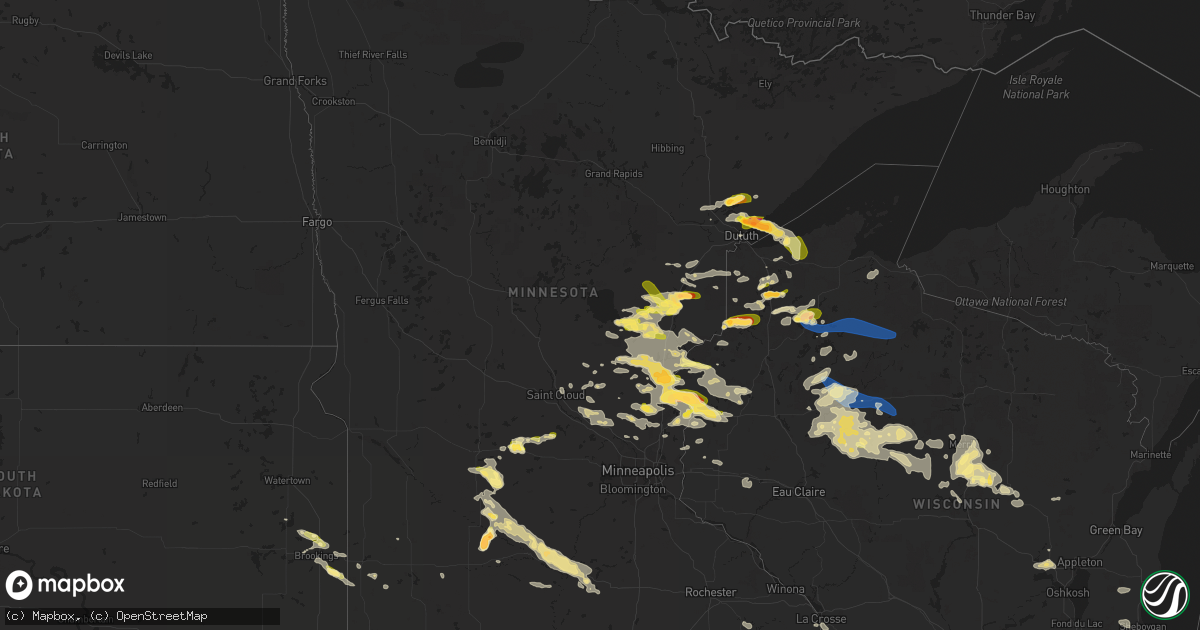
Hail Map in Minnesota on July 27, 2023
Get this storm
July 27 map
$229
one time, instant access
Download today. No call, no setup
Keep the $229
Bought the map and want the full workflow? Apply the entire $229 to a subscription within 7 days. None of it is wasted.
Every map, not just this one
This buys you this map. Subscription and you get every map we run, in the markets you choose from a few cities to whole states to nationwide. Plus real-time alerts the moment a storm fires.
Contact data
Name, contact info, occupancy, even credit band for addresses in the footprint. You go from where it hit to who to call.
Become the source they trust
Unlimited branding weather history reports on demand. You already have the documented answer ready for the property owner, and you are the one who showed up with it.
Property data and RoofTrace estimates
Pull up any address you have got, its value and the exact code rules for that jurisdiction, straight from One Click Code. Then RoofTrace estimates the squares, pitch, and roof value, priced the way you price.
Storm reports in Minnesota
Minnesota
| Date | Description |
|---|---|
| 07/27/20235:40 PM CDT | Quarter sized hail measured 2 miles south of franklin... Mn. Photo provided via social media. Time estimated via radar. |
| 07/27/20235:20 PM CDT | Mix of hail from pea sized to one inch diameter lasted for several minutes. |
| 07/27/20235:15 PM CDT | Report sent via facebook. |
| 07/27/20235:15 PM CDT | Trained spotter reported quarter sized hail in morgan... Mn. Time estimated via radar. |
| 07/27/20235:10 PM CDT | Phoned in report. Mostly quarter size hail but one half dollar size hail stone observed. |
| 07/27/20235:10 PM CDT | Corrects previous hail report from morgan. Trained spotter measured quarter sized hail in the town of morgan... Mn. Time estimated via radar. |
| 07/27/20235:01 PM CDT | Corrects previous hail report from 3 w hinckley. |
| 07/27/20234:55 PM CDT | A local report indicates 1.00 inch wind near 3 W Hinckley |
| 07/27/20234:45 PM CDT | Heavy rain causing surface runoff and minor flooding. |
| 07/27/20234:34 PM CDT | Report from mping: ping pong ball |
| 07/27/20234:20 PM CDT | Half to one inch hail. |
| 07/27/20233:53 PM CDT | A local report indicates 1.50 inch wind near 4 NE Rice Lake |
| 07/27/20233:51 PM CDT | Trained spotter reported numerous 8 to 10-inch diameter trees down across roadways and powerlines down. Time estimated via radar. |
| 07/27/20233:45 PM CDT | Report of several trees down 2 miles ese of rush city... Mn. Time estimated via radar. |
| 07/27/20233:44 PM CDT | A local report indicates 1.75 inch wind near 3 NNE Lester Park |
| 07/27/20233:40 PM CDT | Quarter sized hail reported 3 miles ne of rush city... Mn. Photo provided social media. |
| 07/27/20233:40 PM CDT | Via social media. |
| 07/27/20233:37 PM CDT | Also had trees down in the area. |
| 07/27/20233:36 PM CDT | Report from mping: ping pong ball |
| 07/27/20233:35 PM CDT | Corrects previous tstm wnd dmg report from 1 sw french river. Several trees were bent or snapped halfway up near the railroad tracks at mcquade road. Time estimated by |
| 07/27/20233:35 PM CDT | A local report indicates 2.00 inch wind near 3 W French River |
| 07/27/20233:35 PM CDT | Several medium trees snapped at base and fell over powerlines. Time estimated from radar. |
| 07/27/20233:35 PM CDT | A local report indicates 1.00 inch wind near 1 SE Lester Park |
| 07/27/20233:33 PM CDT | A local report indicates 1.00 inch wind near 2 W Lester Park |
| 07/27/20233:30 PM CDT | A local report indicates 1.00 inch wind near 5 SE Arthyde |
| 07/27/20233:30 PM CDT | Mature maple tree of around a 10 inch diameter down on northeast corner of umd. Time estimated by radar. This corrects an earlier report that relayed a 10 inch radius m |
| 07/27/20233:30 PM CDT | A local report indicates 2.00 inch wind near 3 N Lester Park |
| 07/27/20233:25 PM CDT | A local report indicates 2.00 inch wind near 3 N Lester Park |
| 07/27/20233:25 PM CDT | Corrects previous hail report from 4 ne rice lake. |
| 07/27/20233:18 PM CDT | Some trees were snapped halfway up near the railroad tracks at mcquade road. Time estimated by radar. |
| 07/27/20233:15 PM CDT | Cocorahs station mn-sl-232. |
| 07/27/202311:40 AM CDT | Report from mping: 3-inch tree limbs broken with time estimated based on radar. |
| 07/27/20237:00 AM CDT | Delayed report... Time esimated from radar. Hail quarter to golfball in almelund... With some vehicle damage reported. |
| 07/27/202312:38 AM CDT | 10 inch diameter tree limb blocking roadway. Delayed report via law enforcement. Time estimated by radar. |
| 07/27/202312:20 AM CDT | Several reports of branches down across mankato courtesy of keyc and social media. |
| 07/27/202312:20 AM CDT | Delayed report... Time estimated from radar. Trees and large branches down in skyline. |
| 07/27/202312:20 AM CDT | Delayed report... Time estimated from radar. Picture of large branch down at lions lake park courtesy of keyc and social media. |
| 07/27/202312:10 AM CDT | Delayed report... Time estimated from radar. Picture of large branch down at spring lake park courtesy of keyc and social media. |
| 07/26/202311:40 PM CDT | Correct for time. Report from mping: 3-inch tree limbs broken with time estimated based on radar. |
| 07/26/202311:40 PM CDT | Delayed report... Time esimated from radar. Large pine tree partially uprooted. |
| 07/26/202311:30 PM CDT | Delayed report... Time estimated from radar. Lots of trees down and corn flattened along a line from lafayette to north mankato. |
| 07/26/20239:30 PM CDT | Emergency management reported quarter size hail in the city of lake lillian... Mn. |
| 07/26/20238:50 PM CDT | Report from mping: quarter |
| 07/26/20237:30 PM CDT | Delayed report via facebook... Mix of quarter to half dollar sized hail. |
| 07/26/20237:15 PM CDT | Report received via amateur radio along co rd. 16 two miles north of taylors falls... Mn. |
| 07/26/20237:12 PM CDT | Most of the hail was nickel size. |
| 07/26/20237:00 PM CDT | Estimated 4 inches of rainfall. |
All States Impacted by Hail Map on July 27, 2023
Cities Impacted by Hail Map on July 27, 2023
- Mass City, MI
- Hayward, WI
- Breda, IA
- Marenisco, MI
- Saint Croix Falls, WI
- Centuria, WI
- Jefferson, IA
- Grand Junction, IA
- Wall Lake, IA
- Minong, WI
- Gordon, WI
- Perry, IA
- Rippey, IA
- Ogden, IA
- Balsam Lake, WI
- Amery, WI
- Jeffersonville, IN
- Prospect, KY
- Fort Dodge, IA
- Keene, NH
- Swanzey, NH
- Marlborough, NH
- Harrisville, NH
- Dublin, NH
- Peterborough, NH
- Granville, MA
- Sandisfield, MA
- East Otis, MA
- Otis, MA
- Blandford, MA
- Russell, MA
- Southwick, MA
- Feeding Hills, MA
- Westfield, MA
- West Springfield, MA
- Chicopee, MA
- Southampton, MA
- Holyoke, MA
- Indian Orchard, MA
- Springfield, MA
- Ludlow, MA
- South Hadley, MA
- Belchertown, MA
- Wilbraham, MA
- Granby, MA
- Bondsville, MA
- Three Rivers, MA
- Palmer, MA
- Monson, MA
- Thorndike, MA
- Ware, MA
- Brimfield, MA
- West Warren, MA
- Warren, MA
- West Brookfield, MA
- Duluth, MN
- Sturgeon Lake, MN
- McGrath, MN
- Mcgregor, MN
- Finlayson, MN
- Willow River, MN
- Solon Springs, WI
- Cable, WI
- Harris, MN
- North Branch, MN
- Sandstone, MN
- Askov, MN
- Isle, MN
- Agawam, MA
- East Longmeadow, MA
- Longmeadow, MA
- Hampden, MA
- Taylors Falls, MN
- Grantsburg, WI
- Center City, MN
- Lindstrom, MN
- Cushing, WI
- Brule, WI
- Port Wing, WI
- Maple, WI
- Iron River, WI
- Luck, WI
- Danbury, WI
- Rush City, MN
- Milltown, WI
- Bruno, MN
- Kerrick, MN
- Brook Park, MN
- Hinckley, MN
- Mora, MN
- Morgan, MN
- Grace, ID
- Exeland, WI
- Ladysmith, WI
- Tony, WI
- Glen Flora, WI
- Hawkins, WI
- Glidden, WI
- Butternut, WI
- Soda Springs, ID
- Ogema, WI
- Kennan, WI
- Catawba, WI
- Siren, WI
- Franklin, MN
- Fairfax, MN
- Hector, MN
- Carlton, MN
- Barnum, MN
- Couderay, WI
- Boulder, WY
- Auburn, WY
- Grover, WY
- Avon, MT
- Garrison, MT
- Saginaw, MN
- Bancroft, ID
- Fairfield, OH
- Foxboro, WI
- Foreston, MN
- Foley, MN
- Charles Town, WV
- Braham, MN
- Pine City, MN
- Elizaville, NY
- Walsenburg, CO
- Butte, MT
- Boulder, MT
- Lake Nebagamon, WI
- Winchester, VA
- Superior, WI
- Mud Butte, SD
- Shenandoah Junction, WV
- Shepherdstown, WV
- Sharpsburg, MD
- Kearneysville, WV
- Harpers Ferry, WV
- Anaconda, MT
- Keedysville, MD
- Rohrersville, MD
- Knoxville, MD
- Kettle River, MN
- Wahkon, MN
- Clements, MN
- Grasston, MN
- Ogilvie, MN
- Gallipolis, OH
- Bidwell, OH
- Cheshire, OH
- West Chester, OH
- Tallmansville, WV
- Greencastle, IN
- Drummond, WI
- Alborn, MN
- Canyon, MN
- Frederic, WI
- Webster, WI
- Lander, WY
- Moose Lake, MN
- Somers, CT
- Stafford Springs, CT
- Bainbridge, IN
- Mobile, AL
- Penrose, CO
- Wrenshall, MN
- Waterford, VA
- Lovettsville, VA
- Purcellville, VA
- Paeonian Springs, VA
- Dickerson, MD
- Leesburg, VA
- Cincinnati, OH
- High Bridge, WI
- Woodward, IA
- Faith, SD
- Marysville, MT
- Ojibwa, WI
- Loxley, AL
- Oak Hill, OH
- Point Pleasant, WV
- Stapleton, AL
- Shafer, MN
- Trinidad, CO
- Carlisle, KY
- Salome, AZ
- Stanchfield, MN
- Rock Springs, WY
- Buckhannon, WV
- Vinton, OH
- Philipsburg, MT
- Downey, ID
- Morrow, OH
- Loveland, OH
- Goshen, OH
- South Lebanon, OH
- Maineville, OH
- Dresser, WI
- Lava Hot Springs, ID
- Strasburg, IL
- Windsor, IL
- Kim, CO
- Round Hill, VA
- Berryville, VA
- Ellamore, WV
- Thurman, OH
- York, PA
- Wrightsville, PA
- Wausau, WI
- Merrill, WI
- Gilman, WI
- Isanti, MN
- Stacy, MN
- Watkins, MN
- Litchfield, MN
- Kimball, MN
- Annandale, MN
- South Haven, MN
- Grove City, MN
- Schofield, WI
- Ringle, WI
- Hatley, WI
- Cochise, AZ
- Dragoon, AZ
- Benson, AZ
- Hayes, SD
- Fort Pierre, SD
- Dupree, SD
- Eagle Butte, SD
- White River, SD
- Wood, SD
- Blomkest, MN
- Lake Lillian, MN
- Bird Island, MN
- Olivia, MN
- Bruce, SD
- White, SD
- Brookings, SD
- Aurora, SD
- Wallingford, KY
- Flemingsburg, KY
- Hillsboro, KY
- Mount Olivet, KY
- Brooksville, KY
- Milaca, MN
- Riverton, WY
- Medford, WI
- Rib Lake, WI
- Anniston, AL
- Kadoka, SD
- Philip, SD
- Belvidere, SD
- Cambridge, MN
- Bethel, MN
- Waverly, OH
- Poca, WV
- Charleston, WV
- Athens, WI
- Marshall, MN
- Forest Lake, MN
- Ringling, MT
- South Salem, OH
- Winchester, OH
- West Union, OH
- Whitehall, MT
- Willcox, AZ
- Trilla, IL
- Lerna, IL
- Winter, WI
- Patriot, OH
- Kentwood, LA
- Mosinee, WI
- Dassel, MN
- Weyerhaeuser, WI
- Pinedale, WY
- Conrath, WI
- Sheldon, WI
- Holcombe, WI
- Midland, SD
- Okaton, SD
- Marathon, WI
- Danville, PA
- Wheelersburg, OH
- Franklin Furnace, OH
- Bluemont, VA
- Radisson, WI
- Cynthiana, KY
- Toston, MT
- Roscoe, MT
- Roberts, MT
- Red Lodge, MT
- Brokaw, WI
- Owingsville, KY
- Sharpsburg, KY
- Morehead, KY
- Paris, KY
- Mount Sterling, KY
- Salt Lick, KY
- Looneyville, WV
- Owenton, KY
- Cherry Creek, SD
- Walton, WV
- Reedy, WV
- Elkview, WV
- Spencer, WV
- Gandeeville, WV
- Gay, WV
- Advent, WV
- Kenna, WV
- Lancaster, PA
- Washington Boro, PA
- Columbia, PA
- Ripley, WV
- Evans, WV
- Saint David, AZ
- Becker, MN
- Big Lake, MN
- Atwater, MN
- Mountain Top, PA
- Corinth, KY
- Murdo, SD
- Draper, SD
- Rock River, WY
- Cheyenne, WY
- Absarokee, MT
- Fishtail, MT
- Joliet, MT
- Columbus, MT
- Aniwa, WI
- Birnamwood, WI
- Bruce, WI
- Pleasureville, KY
- Bethlehem, KY
- Lockport, KY
- Campbellsburg, KY
- Comstock, WI
- Daniel, WY
- Big Piney, WY
- Patagonia, AZ
- Princeton, MN
- Moorefield, KY
- Ewing, KY
- Jackson, OH
- Eland, WI
- Wittenberg, WI
- Oak Park, MN
- Wyoming, MN
- Elk River, MN
- Cedar, MN
- Saint Francis, MN
- Anoka, MN
- Andover, MN
- Zimmerman, MN
- Warm Springs, MT
- Moatsville, WV
- Osceola, WI
- Conner, MT
- Gallipolis Ferry, WV
- Henderson, WV
- Sauk Rapids, MN
- Somerset, WI
- New Richmond, WI
- Star Prairie, WI
- Cumberland, WI
- Birchwood, WI
- Bridger, MT
- Lodge Grass, MT
- Lumberport, WV
- Leon, WV
- Thorp, WI
- Lublin, WI
- New Auburn, WI
- Boyd, WI
- Stanley, WI
- Westboro, WI
- Cornell, WI
- Withee, WI
- Thayne, WY
- Millersville, PA
- Laramie, WY
- Sula, MT
- Ellington, CT
- Tolland, CT
- Eminence, KY
- Elliston, MT
- Clear Lake, MN
- Holyoke, MN
- Grover, CO
- Chisago City, MN
- Owen, WI
- Frankfort, KY
- Dalbo, MN
- Poplar, WI
- Connersville, IN
- Brookville, IN
- Chillicothe, OH
- Tigerton, WI
- Pryor, MT
- Blue Creek, OH
- Champion, MI
- Barronett, WI
- Arnoldsburg, WV
- Edgar, WI
- French Creek, WV
- Cosmos, MN
- Wellington, AL
- Ohatchee, AL
- Ashton, WV
- Glenwood, WV
- Isabel, SD
- Georgetown, KY
- Sadieville, KY
- Rothschild, WI
- Willington, CT
- Liberty, WV
- Mattoon, IL
- Stetsonville, WI
- Southside, WV
- Covington, MI
- Saint Cloud, MN
- Lucasville, OH
- McDermott, OH
- Rock Cave, WV
- Crawford, WV
- Cleveland, WV
- Henriette, MN
- Turtle Lake, WI
- Grandy, MN
- Portsmouth, OH
- Eastford, CT
- Ashford, CT
- Stewardson, IL
- Boyce, VA
- Apple Grove, WV
- Crown City, OH
- South Shore, KY
- Greenup, KY
- Raymond, MN
- Willmar, MN
- Onamia, MN
- Daphne, AL
- Berry, KY
- Gibbon, MN
- Timber Lake, SD
- Grantsville, WV
- Elkton, SD
- Flandreau, SD
- Parker City, IN
- Selma, IN
- Mankato, MN
- Woodstock, MN
- Shelbyville, IN
- Stillwater, MN
- Janesville, MN
- Waseca, MN
- Pemberton, MN
- New Ulm, MN
- Nicollet, MN
- Fountain, MN
- Newberry, MI
- Paradise, MI
- Townsend, MT
- Garden City, MN
- Lake Crystal, MN
- Madelia, MN
- Cedar Grove, IN
- West Harrison, IN
- Hamilton, OH
- Okeana, OH
- Oxford, OH
- Gridley, IL
- El Paso, IL
- Chenoa, IL
- Rio Rico, AZ
- Tumacacori, AZ
- Tubac, AZ
- Malone, WI
- Lanesboro, MN
- Ruthton, MN
- Holland, MN
- Harrison, OH
- Valders, WI
- Elgin, AZ
- Shawano, WI
- Oostburg, WI
- Sheboygan, WI
- Sheboygan Falls, WI
- Sault Sainte Marie, MI
- Hasty, CO
- Walnut, IL
- Dorchester, WI
- Curtiss, WI
- Abbotsford, WI
- Woodville, WI
- Hammond, WI
- Baldwin, WI
- Fremont, WI
- Larsen, WI
- Winthrop, MN
- Lafayette, MN
- Madison Lake, MN
- Saint Peter, MN
- Courtland, MN
- Kasota, MN
- Chilton, WI
- Kiel, WI
- La Crosse, WI
- Coon Valley, WI
- Stoddard, WI
- Turners Station, KY
- Colby, WI
- Menomonie, WI
- Walnut Grove, MN
- Revere, MN
- Hokah, MN
- La Crescent, MN
- Winfield, WV
- Eagle Lake, MN
- Sleepy Eye, MN
- College Corner, OH
- Metamora, IN
- Williamstown, KY
- Batesville, IN
- Pleasant Plain, OH
- Knapp, WI
- Lafayette, AL
- Plymouth, WI
- Millersburg, KY
- Olympia, KY
- Aitkin, MN
- Mount Carroll, IL
- Peterson, MN
- Dixon, IL
- Covington, IN
- Perrysville, IN
- Kent, IL
- Stockton, IL
- Gary, IN
- Prairie Du Chien, WI
- Wauzeka, WI
- Ashton, IL
- West Brooklyn, IL
- Amboy, IL
- Ohio, IL
- Sublette, IL
- Greensburg, IN
- Lafayette, IN
- Westpoint, IN
- Hillsdale, NY
- Lebanon, IN
- Thorntown, IN
- Newman, IL
- Hume, IL
- Hebron, IN
- Buckley, IL
- Onarga, IL
- Milford, IL
- Cissna Park, IL
- Attica, IN
- Winamac, IN
- Francesville, IN
- Crown Point, IN
- New England, ND
- Preston, MN
- Medora, ND
- Cassopolis, MI
- Hilbert, WI
- Stockbridge, WI
- Seymour, WI
- Towanda, IL
- Lexington, IL
- Merrillville, IN
- Hobart, IN
- Berrien Springs, MI
- Baroda, MI
- Lanark, IL
- Berrien Center, MI
- Dowagiac, MI
- North Judson, IN
- San Pierre, IN
- Franklin Grove, IL
- Woodstock, CT
- Lyndon, IL
- Erie, IL
- Prophetstown, IL
- Rock Falls, IL
- Forreston, IL
- Polo, IL
- Baileyville, IL
- Freeport, IL
- Shannon, IL
- Hoopeston, IL
- Williamsport, IN
- Rossville, IL
- Rushville, IN
- Milroy, IN
- Bloomington, IL
- Normal, IL
- Sterling, IL
- Laurel, IN
- Pipestone, MN
- Reedsville, WI
- Manitowoc, WI
- Morrison, IL
- Mendota, IL
- Utica, IL
- Earlville, IL
- Oldenburg, IN
- Weyauwega, WI
- Hortonville, WI
- Embarrass, WI
- Clintonville, WI
- Lake Benton, MN
- Sabula, IA
- Pearl City, IL
- Valparaiso, IN
- Volga, SD
- Portage, IN
- Schererville, IN
- Highland, IN
- Lake Station, IN
- Griffith, IN
- Wellington, IL
- Thawville, IL
- Savanna, IL
- Thomson, IL
- Union Mills, IN
- Lena, IL
- Winslow, IL
- Lake Norden, SD
- Antigo, WI
- Chadwick, IL
- Milledgeville, IL
- Hartford, MI
- New Bedford, IL
- Deer Grove, IL
- Princeton, IL
- Sheffield, IL
- Tampico, IL
- Eastman, WI
- Elkhart, IN
- Kouts, IN
- Goshen, IN
- Bristol, IN
- Middlebury, IN
- Manilla, IN
- Hammond, IN
- East Chicago, IN
- Ambia, IN
- New London, WI
- South Range, WI


