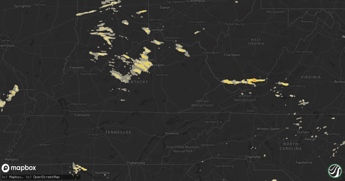
Hail Map in South Carolina on July 27, 2012
Get this storm
July 27 map
$229
one time, instant access
Download today. No call, no setup
Keep the $229
Bought the map and want the full workflow? Apply the entire $229 to a subscription within 7 days. None of it is wasted.
Every map, not just this one
This buys you this map. Subscription and you get every map we run, in the markets you choose from a few cities to whole states to nationwide. Plus real-time alerts the moment a storm fires.
Contact data
Name, contact info, occupancy, even credit band for addresses in the footprint. You go from where it hit to who to call.
Become the source they trust
Unlimited branding weather history reports on demand. You already have the documented answer ready for the property owner, and you are the one who showed up with it.
Property data and RoofTrace estimates
Pull up any address you have got, its value and the exact code rules for that jurisdiction, straight from One Click Code. Then RoofTrace estimates the squares, pitch, and roof value, priced the way you price.
Storm reports in South Carolina
South Carolina
| Date | Description |
|---|---|
| 07/27/20126:40 PM CDT | Sheriff dispatch reported trees down on power lines along old cherokee trail. |
| 07/27/20126:34 PM CDT | Public reported several large limbs down along with some pine tree topped by strong winds along hollywood road. |
| 07/27/20126:26 PM CDT | Numerous trees and powerlines were blown down in the tamassee community. |
| 07/27/20126:12 PM CDT | Sheriff dispatch reported a tree down in the city of newberry. |
| 07/27/20126:10 PM CDT | Highway patrol reported a tree down at brown chapel road and brown chapel drive. |
| 07/27/20125:56 PM CDT | Trees and large limbs down in cedar lake subdivision |
| 07/27/20125:35 PM CDT | One tree was reported down near the intersection of moffett road and highway 174. |
| 07/27/20125:29 PM CDT | Tree down near the intersection of highway 164 and rodd drive. |
| 07/27/20125:28 PM CDT | Charleston county dispatch center reported a tree down on point of pines rd on edisto island. |
| 07/27/20125:25 PM CDT | Tree down at intersection of old milton road and jefferson davis road. |
| 07/27/20125:25 PM CDT | One tree down on oak ridge drive and another at the intersection of panola avenue and south main street. |
| 07/27/20125:20 PM CDT | Tree on roadway at intersection of midway school road and highway 72. |
| 07/27/20125:14 PM CDT | Trees down around fort mill. |
| 07/27/20125:10 PM CDT | Tree reported down at intersection of hwy 15 and east old camden road. Time estimated by radar. |
| 07/27/20124:46 PM CDT | One tree was reported down near the intersection of needles road and joe frazier road. |
| 07/27/20124:36 PM CDT | Trees down in the sharon and york area. |
| 07/27/20124:28 PM CDT | Tree down in highway at us 52 and rosenwald road south of society hill. |
| 07/27/20124:25 PM CDT | Two trees were reported down along highway 363. |
| 07/27/20124:25 PM CDT | Tree down on pocotaligo road. |
| 07/27/20124:25 PM CDT | One tree was reported down near the intersection of shadowmoss parkway and ashley river road. |
| 07/27/20124:23 PM CDT | Public reported a tree uprooted and limbs on powerlines near mcbee. |
| 07/27/20124:22 PM CDT | Tree in roadway and large limbs down in musgrove mill st pk. |
| 07/27/20124:20 PM CDT | Tree down across railroad tracks on high point road. Time estimated by radar. |
| 07/27/20124:02 PM CDT | The jasper county 911 call center relayed a report of a tree down on moorer avenue. |
| 07/27/20124:02 PM CDT | The jasper county 911 call center reported a tree down on best street. |
| 07/27/20123:52 PM CDT | Trees down on providence road in town. 1 tree also down on pleasant school rd northeast of town. |
| 07/27/20123:46 PM CDT | Large tree down near intersection of highways 79 and 36 |
| 07/27/20123:44 PM CDT | Sheriff dispatch reported a tree on a house and power lines down on cedar creek road near highway 102. |
| 07/27/20123:44 PM CDT | Sheriff dispatch reported a roof blown off of a storage building and trees down along cedar creek road. |
| 07/27/20123:44 PM CDT | Power line down on crenshaw rd. |
| 07/27/20123:37 PM CDT | Highway patrol reported power lines in the roadway at highway 34 and kellytown road. |
| 07/27/20123:24 PM CDT | Trees down with a few in roadways. |
| 07/27/20123:22 PM CDT | Highway patrol reported a tree down along i-26 in the westbound direction at mile marker 61. |
| 07/27/20123:16 PM CDT | Highway patrol reported at tree down in windsor |
| 07/27/20123:13 PM CDT | One tree was reported down on bonnie dune road. |
| 07/27/20123:03 PM CDT | Highway patrol reported a tree in the roadway at woodfield road and independent boulevard. |
| 07/27/20123:00 PM CDT | Highway patrol reported trees down along highway 178 at johnson king road and mack edisto road. |
| 07/27/20122:57 PM CDT | Highway patrol reported a tree in the roadway at kennedy pond road and trotter road. |
| 07/27/20122:52 PM CDT | A tree was blown down bringing down 2 power poles. |
| 07/27/20122:41 PM CDT | The colleton county 911 center relayed a report of a tree down near the intersection of hiers corner road and forest circle. |
| 07/27/20122:39 PM CDT | A few trees down in the six mile area. |
| 07/27/20122:34 PM CDT | One tree was reported down along interstate 95 between black creek road and crosby corner road. |
| 07/27/20122:34 PM CDT | A tree was reported down along interstate 95 near beach road. |
| 07/27/20122:32 PM CDT | Highway patrol reported a tree down across the roadway at the intersection of camp rawls road and magpie street. |
| 07/27/20121:58 PM CDT | A few large limbs down at table rock state park. |
| 07/26/20128:23 PM CDT | Power lines down and tree down on fews chapel road near hwy 101 |
| 07/26/20128:20 PM CDT | Tree in roadway at intersection of highway 25 and highway 414. |
| 07/26/20127:27 PM CDT | Large limbs down in ninety-six national historic site. |
All States Impacted by Hail Map on July 27, 2012
Cities Impacted by Hail Map on July 27, 2012
- Hartsville, SC
- Darlington, SC
- McBee, SC
- Patrick, SC
- Society Hill, SC
- Louisville, KY
- Lizton, IN
- North Salem, IN
- Hinton, WV
- Jumping Branch, WV
- Pipestem, WV
- Owenton, KY
- Celestine, IN
- Birdseye, IN
- Taswell, IN
- Eckerty, IN
- Columbus, IN
- Nashville, IN
- Howell, MI
- Perry, MI
- Byron, MI
- Webberville, MI
- Morrice, MI
- Williamston, MI
- Fowlerville, MI
- Magnolia, KY
- Summersville, KY
- Petersburg, KY
- Aurora, IN
- Lawrenceburg, IN
- Burlington, KY
- Henderson, MI
- Bannister, MI
- Oakley, MI
- Chesaning, MI
- Elsie, MI
- Fort Wayne, IN
- Hoagland, IN
- Ossian, IN
- Yoder, IN
- Decatur, IN
- Brighton, MI
- Central, IN
- Mauckport, IN
- Corydon, IN
- Claxton, GA
- Leopold, MO
- Whitewater, MO
- Marble Hill, MO
- Burfordville, MO
- Bloomfield, IN
- Trafalgar, IN
- Beech Grove, IN
- Indianapolis, IN
- Nathalie, VA
- Moores Hill, IN
- Rising Sun, IN
- Guilford, IN
- Cecilia, KY
- Vine Grove, KY
- Elizabethtown, KY
- Rineyville, KY
- Montvale, VA
- Baconton, GA
- Bremen, IN
- Oneonta, AL
- Rocky Gap, VA
- Bastian, VA
- Yemassee, SC
- Green Pond, SC
- Seabrook, SC
- Lockport, KY
- Lamont, FL
- Killen, AL
- Lexington, AL
- North Spring, WV
- Ikes Fork, WV
- Iaeger, WV
- Gilbert, WV
- Baisden, WV
- Davy, WV
- Mohawk, WV
- Wichita Falls, TX
- Burkburnett, TX
- Kadoka, SD
- Fort Mitchell, AL
- Sadler, TX
- Sherman, TX
- Whitesboro, TX
- Gadsden, AL
- Seven Springs, NC
- Breckenridge, MI
- Elwell, MI
- Merrill, MI
- Ithaca, MI
- Wheeler, MI
- Riverdale, MI
- Saint Louis, MI
- Saint Charles, MI
- Sumner, MI
- Alma, MI
- Willisburg, KY
- Bloomfield, KY
- Whitestown, IN
- Westfield, IN
- Carmel, IN
- Zionsville, IN
- Bluffton, SC
- Poplar Bluff, MO
- Wappapello, MO
- Monticello, GA
- Mansfield, GA
- Seymour, IN
- Millington, MI
- Fostoria, MI
- Flora, IN
- Wayside, WV
- Ballard, WV
- Talcott, WV
- Forest Hill, WV
- Greenville, WV
- Camden, MI
- Montgomery, MI
- Pioneer, OH
- Montpelier, OH
- Edon, OH
- Saint Louisville, OH
- Utica, OH
- Florence, AL
- Milford, MI
- Wixom, MI
- New Hudson, MI
- Novi, MI
- Walled Lake, MI
- South Lyon, MI
- Commerce Township, MI
- Lawrenceburg, KY
- Frankfort, KY
- Versailles, KY
- Grafton, OH
- Litchfield, OH
- Danville, IN
- Brownsburg, IN
- Tuscumbia, AL
- Muscle Shoals, AL
- Leighton, AL
- Noblesville, IN
- Shepherdsville, KY
- Owosso, MI
- Greensburg, IN
- Hope, IN
- Hartsville, IN
- Shelbyville, KY
- Varnville, SC
- Hampton, SC
- Luray, SC
- Brunson, SC
- New Paris, IN
- Wagener, SC
- Franklin, GA
- Fitzgerald, GA
- Louisville, MS
- Moultrie, GA
- Hartsfield, GA
- Meigs, GA
- Claudville, VA
- Hodgenville, KY
- Hardy, VA
- Roanoke, VA
- Missoula, MT
- Rozet, WY
- Wall, SD
- Wasta, SD
- Roanoke Rapids, NC
- Ellettsville, IN
- Gosport, IN
- Bloomington, IN
- Bland, VA
- Orleans, IN
- Glasgow, KY
- Edmonton, KY
- Carbon, IN
- Rosedale, IN
- Dry Ridge, KY
- Midkiff, TX
- Springfield, KY
- Manchester, MI
- English, IN
- Herndon, WV
- Pineville, WV
- Natural Bridge Station, VA
- Natural Bridge, VA
- Harrodsburg, KY
- Taylorsville, KY
- Waddy, KY
- Mount Eden, KY
- Salvisa, KY
- Marion, MT
- Delta, OH
- Swanton, OH
- Tuthill, SD
- Saint Francis, SD
- Merriman, NE
- Cody, NE
- Coopersville, MI
- Ravenna, MI
- Dixon, MT
- Pineland, SC
- Garnett, SC
- Odd, WV
- Flat Top, WV
- Camp Creek, WV
- Pleasureville, KY
- Bagdad, KY
- Terre Haute, IN
- McGee, MO
- Advance, MO
- Gipsy, MO
- Puxico, MO
- Millersville, MO
- Zalma, MO
- Sturdivant, MO
- Glenallen, MO
- Wirtz, VA
- Boones Mill, VA
- Atlanta, IN
- Moorcroft, WY
- Senecaville, OH
- Greenville, NC
- Moneta, VA
- Campbellsburg, IN
- Williamsville, MO
- Rossford, OH
- Perrysburg, OH
- Liberty, IN
- Brownsville, IN
- Connersville, IN
- Bedford, IN
- Edmore, MI
- Six Lakes, MI
- Stanton, MI
- Lakeview, MI
- Mitchell, IN
- Heltonville, IN
- Tunnelton, IN
- Piedmont, SD
- Sheridan, IN
- Cicero, IN
- Tipton, IN
- Arcadia, IN
- Blakely, GA
- Macon, MS
- Brookwood, AL
- Hanover, WV
- Athens, WV
- Nimitz, WV
- New Richmond, WV
- Josephine, WV
- Hurley, VA
- Wyoming, WV
- Panther, WV
- Stephenson, WV
- Ghent, WV
- Union, WV
- Spanishburg, WV
- Gap Mills, WV
- Fanrock, WV
- Welch, WV
- Wolfcreek, WV
- Lerona, WV
- Princeton, WV
- Lashmeet, WV
- Matoaka, WV
- Wharncliffe, WV
- Peterstown, WV
- Snow Hill, NC
- Flemingsburg, KY
- Tollesboro, KY
- Wallingford, KY
- Lakeside, MT
- Wilsonville, AL
- Anaconda, MT
- Fort Stockton, TX
- Salley, SC
- Siler City, NC
- Staley, NC
- Nocona, TX
- Sandersville, GA
- Brooksville, MS
- Stokes, NC
- Southgate, MI
- Ripley, OH
- Rogersville, AL
- Ashville, AL
- Woodbury, GA
- Finchville, KY
- Fisherville, KY
- Simpsonville, KY
- Waynesboro, GA
- Maysville, KY
- Aberdeen, OH
- Morehead, KY
- Manchester, OH
- Olive Hill, KY
- Vanceburg, KY
- Emerson, KY
- Weston, WY
- Stilesville, IN
- Coatesville, IN
- Fillmore, IN
- Kokomo, IN
- Ocilla, GA
- Chappells, SC
- Saluda, SC
- Saint Ignatius, MT
- Toomsboro, GA
- Alex, OK
- Bradley, OK
- La Grange, NC
- Chadron, NE
- Oelrichs, SD
- Cornelius, NC
- Griffin, GA
- Youngsville, PA
- Sugar Grove, PA
- Commiskey, IN
- Louisville, AL
- Clayton, AL
- Holden, LA
- De Mossville, KY
- Falmouth, KY
- Butler, KY
- Williamstown, KY
- Crittenden, KY
- Salem, VA
- French Lick, IN
- Greensburg, KY
- Walstonburg, NC
- Bedford, VA
- Buchanan, VA
- Springville, IN
- Paris, IL
- West Terre Haute, IN
- New Goshen, IN
- Georgetown, IN
- Greenville, IN
- New Salisbury, IN
- Ninnekah, OK
- Chickasha, OK
- Greencastle, IN
- Brazil, IN
- Sturgis, SD
- Athens, AL
- Jasper, IN
- Otwell, IN
- Shoals, IN
- Crookston, NE
- Cuthbert, GA
- Littleton, NC
- Hodges, SC
- Aliceville, AL
- Carrollton, AL
- Newnan, GA
- Lena, MS
- Bethune, SC
- Mount Washington, KY
- Owanka, SD
- New Underwood, SD
- Butte, MT
- Pelion, SC
- Danville, VA
- Hillsborough, NC
- Rougemont, NC
- Wilson, OK
- Piketon, OH
- Greenwood, IN
- Gillette, WY
- Jeffersonville, IN
- Sellersburg, IN
- Clarksville, IN
- Brownstown, IN
- Vallonia, IN
- Owensburg, IN
- Freetown, IN
- Avoca, IN
- Medora, IN
- Norman, IN
- Oolitic, IN
- Lyons, IN
- Clinton, SC
- Laurens, SC
- Bethlehem, KY
- Marysville, IN
- Sweeden, KY
- Farmville, NC
- Continental, OH
- Grosse Ile, MI
- Bardstown, KY
- Boston, KY
- Saint Jo, TX
- Central, SC
- Six Mile, SC
- Fortson, GA
- New Hope, KY
- Irvington, KY
- Sonora, KY
- Glendale, KY
- New Haven, KY
- Guston, KY
- Buffalo, KY
- Radcliff, KY
- Ekron, KY
- Custer, KY
- Loretto, TN
- Lawrenceburg, TN
- Decatur, AL
- Okatie, SC
- Milford, OH
- Healdton, OK
- Locust Grove, GA
- Gretna, VA
- Hurt, VA
- Lynch Station, VA
- Harrisburg, NE
- Osseo, MI
- Waldron, MI
- Alvordton, OH
- Power, MT
- Mill Creek, OK
- Sulphur, OK
- Jackson, GA
- Jenkinsburg, GA
- Hardeeville, SC
- Mountville, SC
- Nemo, SD
- Waverly, OH
- Beaver, OH
- Crestview, FL
- Defuniak Springs, FL
- Saline, MI
- Ottawa, OH
- Cloverdale, OH
- Groveoak, AL
- Owens Cross Roads, AL
- Oakboro, NC
- Lagrange, OH
- Iron City, TN
- Sheffield, AL
- Laingsburg, MI
- Bancroft, MI
- Pennington, AL
- Wauseon, OH
- Smiths Station, AL
- Phenix City, AL
- Durand, MI
- Bigfork, MT
- Midway, KY
- Coxs Creek, KY
- Worthville, KY
- Fairfield, KY
- Chaplin, KY
- New Liberty, KY
- Eminence, KY
- Brant, MI
- Nederland, CO
- Shepherd, MI
- Philadelphia, MS
- Jackson, OH
- Ray, OH
- Troutville, VA
- Fincastle, VA
- Roff, OK
- Boaz, AL
- Horton, AL
- Vale, SD
- Genoa, OH
- Elmore, OH
- Graytown, OH
- Woodville, OH
- Martin, OH
- Elwood, IN
- Brandenburg, KY
- Laconia, IN
- Glenview, KY
- Masonic Home, KY
- New Albany, IN
- Prospect, KY
- Paoli, IN
- Howe, TX
- Collinsville, TX
- Plains, GA
- West Blocton, AL
- Bunker Hill, IN
- Peru, IN
- Mayville, MI
- Russellville, AL
- Vassar, MI
- Ringgold, VA
- Altoona, AL
- New Hope, AL
- Sinks Grove, WV
- Salem, AL
- Lowell, MI
- Galveston, IN
- Walton, IN
- Ada, MI
- Keenesburg, CO
- Lapel, IN
- Golden, CO
- Madison, GA
- Eatonton, GA
- Charlo, MT
- Fortville, IN
- Pittsboro, IN
- Fishers, IN
- Mccordsville, IN
- Avon, IN
- Nashville, NC
- Berry, KY
- Windsor, SC
- Aiken, SC
- Glenwood, IN
- Oakwood, OH
- Rollins, MT
- Proctor, MT
- Forest, MS
- Pittsview, AL
- Java, VA
- Vernon Hill, VA
- Russiaville, IN
- Forest, IN
- Sharpsville, IN
- Kempton, IN
- McKenzie, AL
- Old Appleton, MO
- Leoma, TN
- Ferdinand, IN
- Battletown, KY
- Huntingburg, IN
- Holland, IN
- Dale, IN
- Salem, IN
- Newton Grove, NC
- Mount Olive, NC
- Zebulon, NC
- Wendell, NC
- Knightdale, NC
- Milton, FL
- Foster, KY
- Floyds Knobs, IN
- Raleigh, NC
- Nappanee, IN
- Goshen, IN
- Wakarusa, IN
- Stanfield, NC
- Locust, NC
- Monroeville, AL
- Lebanon, IN
- Jamestown, IN
- Chapel Hill, NC
- Ninety Six, SC
- Brownsboro, AL
- Alton, VA
- Milton, NC
- Sutherlin, VA
- Prospect Hill, NC
- Hurdle Mills, NC
- Cedar Grove, NC
- Lauderdale, MS
- Ridgeland, SC
- Laurel Hill, FL
- Munfordville, KY
- Bonnieville, KY
- Solsberry, IN
- Register, GA
- Paris Crossing, IN
- McCamey, TX
- Valier, MT
- Browning, MT
- Quinn, SD
- Ionia, MI
- Lyons, MI
- Pewamo, MI
- Linton, IN
- Plainfield, IN
- Spencer, IN
- Orleans, MI
- Milan, IN
- North Bend, OH
- Sunman, IN
- Laurel, IN
- Metamora, IN
- Brookville, IN
- Mammoth Cave, KY
- Cub Run, KY
- Crystal Hill, VA
- Scottsburg, VA
- Clover, VA
- Halifax, VA
- Randolph, VA
- Hemlock, MI
- Ligonier, IN
- Syracuse, IN
- Millersburg, IN
- Mission, SD
- Springville, AL
- Charlestown, IN
- Avon Lake, OH
- Sheffield Lake, OH
- Eutaw, AL
- Lucasville, OH
- Rushville, IN
- Petrolia, TX
- Parrott, GA
- Liberty, NC
- Ramseur, NC
- Franklinville, NC
- Gurley, AL
- Statesville, NC
- Mount Olivet, KY
- Louisburg, NC
- Franklinton, NC
- Guntersville, AL
- Moulton, AL
- South Boston, VA
- Galion, OH
- Castalia, NC
- Kalispell, MT
- Wellington, OH
- Clyo, GA
- Cut Bank, MT
- Kendallville, IN
- Milroy, IN
- Shellman, GA
- Velpen, IN
- Dubois, IN
- Schnellville, IN
- Saint Anthony, IN
- Marengo, IN
- Brevard, NC
- Altavista, VA
- Tifton, GA
- Hardyville, KY
- Canmer, KY
- Cleveland, AL
- Blountsville, AL
- Cedartown, GA
- Gibsonville, NC
- Elon, NC
- Burlington, NC
- Sulligent, AL
- Vernon, AL
- Bargersville, IN
- Greenfield, IN
- New Palestine, IN
- Spring Hope, NC
- Lucedale, MS
- Mill Spring, NC
- Timberlake, NC
- Roxboro, NC
- Leasburg, NC
- Waterloo, SC
- Pooler, GA
- Callands, VA
- Chatham, VA
- Big Lake, TX
- Neelyville, MO
- Thomson, GA
- Bethel, NC
- Northville, MI
- Mebane, NC
- Ashley, MI
- Hilton Head Island, SC
- Vinton, VA
- Covington, GA
- Geraldine, AL
- Henrietta, TX
- Snover, MI
- Sandusky, MI
- White Pigeon, MI
- Bennett, CO
- Topeka, IN
- Midway, AL
- Greenville, MO
- Worthington, IN
- Millport, AL
- Lyons, OH
- Fayette, OH
- Lanesville, IN
- Mooresville, NC
- Beaverton, AL
- Morganton, NC
- Nebo, NC
- Flat Rock, IN
- Sharpsburg, GA
- Deputy, IN
- Payneville, KY
- Florala, AL
- Kannapolis, NC
- Davidson, NC
- Concord, NC
- New Boston, MI
- Early Branch, SC
- Canton, MS
- Camden, MS


