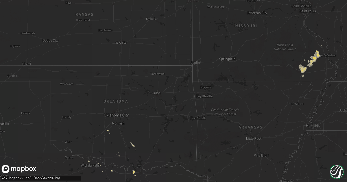
Hail Map on July 27, 2012
Get this storm
July 27 map
$229
one time, instant access
Download today. No call, no setup
Keep the $229
Bought the map and want the full workflow? Apply the entire $229 to a subscription within 7 days. None of it is wasted.
Every map, not just this one
This buys you this map. Subscription and you get every map we run, in the markets you choose from a few cities to whole states to nationwide. Plus real-time alerts the moment a storm fires.
Contact data
Name, contact info, occupancy, even credit band for addresses in the footprint. You go from where it hit to who to call.
Become the source they trust
Unlimited branding weather history reports on demand. You already have the documented answer ready for the property owner, and you are the one who showed up with it.
Property data and RoofTrace estimates
Pull up any address you have got, its value and the exact code rules for that jurisdiction, straight from One Click Code. Then RoofTrace estimates the squares, pitch, and roof value, priced the way you price.
States Impacted by Hail Map on July 27, 2012
Storm reports
Georgia
| Date | Description |
|---|---|
| 07/27/20126:20 PM CDT | Muscogee county 911 relayed a report of several trees down in north columbus. Time is based on radar. |
| 07/27/20125:20 PM CDT | Pike county relayed a report of two trees down on highway 18. Time is based on radar. |
| 07/27/20125:15 PM CDT | Lamar county 911 relayed a report of a tree down and a powerline down in far northern lamar county. Time is based on radar. |
| 07/27/20124:47 PM CDT | Butts county 911 relayed a report of two trees down in western butts county. Time is based on radar. |
| 07/27/20124:43 PM CDT | Spalding county 911 relayed a report of four trees down on powerlines in northern spalding county. Time is based on radar. |
| 07/27/20124:37 PM CDT | Sheriff dispatch reported several trees down in the county. |
| 07/27/20124:37 PM CDT | Fayette county 911 relayed a report of a tree down on highway 92. Time is based on radar. |
| 07/27/20124:36 PM CDT | Newton county 911 relayed a report of a few trees down in far southern newton county. Time is based on radar. |
| 07/27/20124:30 PM CDT | Sheriff dispatch reported trees down just west of appling. |
| 07/27/20124:29 PM CDT | Sheriff dispatch reported several trees down along highway 56 between waynesboro and midville. |
| 07/27/20124:26 PM CDT | Sheriff dispatch reported power lines down near craig road. |
| 07/27/20124:05 PM CDT | One tree reported down in western jefferson county. Time is based on radar. |
| 07/27/20123:51 PM CDT | 7 trees down and several power lines down from east newnan to turin areas. |
| 07/27/20123:51 PM CDT | Media relayed a report of trees and powerlines down on airline road. Time is based on radar. |
| 07/27/20123:00 PM CDT | Polk county 911 relayed a report of several trees down south of cedartown. Time is based on radar. |
| 07/27/20123:00 PM CDT | Wilkinson 911 relayed a report of numerous trees down in toomsboro...time is based on radar. |
| 07/27/20122:56 PM CDT | The effingham 911 call center relayed a report of one tree down near the intersection of highway 17 and springfield tusculum road. |
| 07/27/20122:07 PM CDT | The bulloch county 911 center relayed a report of trees and power lines down near the intersection of union church road and nevils daisy road. |
Ohio
| Date | Description |
|---|---|
| 07/27/20124:59 PM CDT | 6 trees down and one camper blown into a field. Tree limbs on power lines causing power outage. Tree blown on to truck in downtown. |
| 07/27/20124:55 PM CDT | Trees and power lines down. Time estimated from radar. |
| 07/27/20124:39 PM CDT | A few large limbs down. |
| 07/27/20124:25 PM CDT | A local report indicates 1.00 inch wind near 3 NE PERRYSBURG |
| 07/27/20124:11 PM CDT | 4 inch diameter branches down in downtown cincinnati. |
| 07/27/20124:04 PM CDT | A tree was downed in sayler park. |
| 07/27/20124:02 PM CDT | A tree was downed at the fernbank golf course. |
| 07/27/20124:00 PM CDT | A band stage was damaged in forest park. |
| 07/27/20123:58 PM CDT | Several large trees snapped |
Kentucky
| Date | Description |
|---|---|
| 07/27/20126:51 PM CDT | Trees down in bethel. |
| 07/27/20126:51 PM CDT | Trees down on taylor mill road. |
| 07/27/20126:50 PM CDT | Trees down with some on cars on mockingbird lane...high street...ky 36 on railroad tracks...ox bow road...and locust grove road |
| 07/27/20126:49 PM CDT | Trees down on fleming road. |
| 07/27/20126:46 PM CDT | Multiple reports of widespread trees and power lines down making roads impassable including in the thornhill area |
| 07/27/20126:46 PM CDT | Trees down on elizaville road. |
| 07/27/20126:40 PM CDT | Trees and power lines reported down |
| 07/27/20126:37 PM CDT | Large tree fell on a house on nole ave |
| 07/27/20126:36 PM CDT | Spotter reports quarter size hail |
| 07/27/20126:30 PM CDT | Quarter size hail reported near westport and goose creek road |
| 07/27/20126:28 PM CDT | Report of quarter size hail in rolling hills via facebook |
| 07/27/20126:26 PM CDT | Numerous trees down near cynthiana |
| 07/27/20126:25 PM CDT | Tree down on power line. Reported through facebook. |
| 07/27/20126:24 PM CDT | Trees down on clore jackson road |
| 07/27/20126:19 PM CDT | Half of a maple tree down on power lines about 1 mile east of ballard hs |
| 07/27/20126:10 PM CDT | A few trees down |
| 07/27/20125:55 PM CDT | Several trees down |
| 07/27/20125:42 PM CDT | Tree down on dawkins road |
| 07/27/20125:42 PM CDT | Tree down on westport and highway 524 |
| 07/27/20125:22 PM CDT | A local report indicates 62 MPH wind near CARROLLTON |
| 07/27/20125:17 PM CDT | 12 inch diameter tree down |
| 07/27/20125:06 PM CDT | Partial roof ripped off of a garage on culls ridge road near bedford |
| 07/27/20125:02 PM CDT | Tree reported down on race track road in the milton area |
| 07/27/20124:25 PM CDT | Shingles torn off a roof near kentucky route 16 in taylor mill. Numerous trees down in the area. |
| 07/27/20124:14 PM CDT | Several trees down. |
| 07/27/20124:08 PM CDT | Large trees down |
| 07/27/201211:11 AM CDT | Powerlines down near conley bottom resort. |
| 07/27/201211:05 AM CDT | Tree down on denny lane. |
| 07/26/201211:11 PM CDT | Powerlines down near conley bottom resort. |
| 07/26/201211:05 PM CDT | Tree down on denny lane. |
| 07/26/201210:57 PM CDT | Trees down on highway 196. |
| 07/26/201210:50 PM CDT | Reports called into local radio station of trees down in the salem community...approx. 5 east of russell springs |
| 07/26/201210:44 PM CDT | Trees down on highway 635. |
| 07/26/201210:26 PM CDT | Trees down across power lines. |
| 07/26/201210:15 PM CDT | Power lines down on hord street |
| 07/26/201210:13 PM CDT | Dispatch reports trees down |
| 07/26/201210:10 PM CDT | Dispatch reports tree blocking road in bengal |
| 07/26/20129:41 PM CDT | Dispatch reports trees down across the county |
| 07/26/20129:37 PM CDT | Trees and power lines down |
| 07/26/20129:26 PM CDT | Tree down and partially blocking springfield road. |
| 07/26/20129:23 PM CDT | Tree down |
| 07/26/20129:11 PM CDT | Tree down on a home |
| 07/26/20129:10 PM CDT | Tree down on a house... Temporarily trapping a person inside in the henderson woods subdivision. |
| 07/26/20128:44 PM CDT | Trees down at 4400 waddy road |
| 07/26/20128:32 PM CDT | Large portion of tree down in eastern spencer county... Time and location estimated |
| 07/26/20128:27 PM CDT | Dispatch reports trees down near knob creek road and ky 44 w along with a blown transformer |
| 07/26/20128:18 PM CDT | Dispatch reports tree down with power outages |
| 07/26/20128:15 PM CDT | A local report indicates 60 MPH wind near LOUISA |
| 07/26/20128:15 PM CDT | Trees down on little mud lick road. |
| 07/26/20128:03 PM CDT | Trees down on hwy 1092. |
| 07/26/20127:58 PM CDT | Trees down on hwy 469. |
| 07/26/20127:57 PM CDT | A local report indicates 1.00 inch wind near GRAYSON |
| 07/26/20127:50 PM CDT | Large branches broken. |
| 07/26/20127:45 PM CDT | Reports of numerous trees down as well as power outages in anderson county |
| 07/26/20127:40 PM CDT | Numerous trees down around olive hill...reports of power outages as well |
| 07/26/20127:40 PM CDT | 18 tree down on u.s. 62 near wild turkey trace |
| 07/26/20127:36 PM CDT | Lex reported 57 knot gust |
| 07/26/20127:35 PM CDT | Tops of a pine tree and sycamore tree were broken off. |
| 07/26/20127:35 PM CDT | One tree down on hwy 460. |
| 07/26/20127:35 PM CDT | Numerous trees down on route 60 around the town of globe |
| 07/26/20127:31 PM CDT | Telephone poles reported down along with blown transformers near i-65 |
| 07/26/20127:31 PM CDT | A local report indicates 65 MPH wind near 1 N LAWRENCEBURG |
| 07/26/20127:30 PM CDT | Trees down on highways 519 and 1002. |
| 07/26/20127:30 PM CDT | Large treen down on highway 504 near gimlet. |
| 07/26/20127:26 PM CDT | Northeast ymca reports destroyed greenhouse and two large downed trees |
| 07/26/20127:23 PM CDT | Trees down on dry creek road. |
| 07/26/20127:21 PM CDT | Trees down on us 60 near rowan and carter county line. |
| 07/26/20127:18 PM CDT | Trees down on highway 377. |
| 07/26/20127:10 PM CDT | Trees down in salt lick. |
| 07/26/20127:00 PM CDT | Trees down on ringos mills road. |
| 07/26/20127:00 PM CDT | Trees down on day road. |
North Carolina
| Date | Description |
|---|---|
| 07/27/20126:45 PM CDT | Chatham 911 call center reports several trees down just west of siler city near the randolph county line. |
| 07/27/20126:40 PM CDT | Quarter size hail |
| 07/27/20126:30 PM CDT | Tree down on home...hwy 740 and thompson rd |
| 07/27/20126:24 PM CDT | Tree down on austin road |
| 07/27/20126:00 PM CDT | County 911 call center reports several trees down in the louisburg area. |
| 07/27/20125:55 PM CDT | Trees down between waxhaw and monroe. Also a powerline down on highway 74 in monroe causing power to be out for part of the city. |
| 07/27/20125:50 PM CDT | Numerous trees down in siler city |
| 07/27/20125:30 PM CDT | A few locations with powerlines down and at least two of those with limbs bringing the powerlines down. |
| 07/27/20125:24 PM CDT | Trees down near breeze and guess road |
| 07/27/20125:05 PM CDT | Trees and power lines down along graham rd near highway 150. |
| 07/27/20125:02 PM CDT | Tree down |
| 07/27/20125:02 PM CDT | Trees and powerlines down |
| 07/27/20124:53 PM CDT | Trees down in the vicinity of davidson. |
| 07/27/20124:50 PM CDT | Tree down |
| 07/27/20124:40 PM CDT | Trees down in the vicinity of mooresville. |
| 07/27/20124:37 PM CDT | Multiple trees and power lines down... Transformer damaged |
| 07/27/20124:35 PM CDT | Tree down |
| 07/27/20124:31 PM CDT | Tree down |
| 07/27/20124:20 PM CDT | Large tree limbs blown down. Time estimated. |
| 07/27/20124:17 PM CDT | A tree and multiple large tree limbs were blown down near the intersection of highway 772 and dillard road. |
| 07/27/20124:10 PM CDT | Tree down at piedmont electric |
| 07/27/20124:00 PM CDT | Duke power reported 5000 power outages due to fallen limbs and trees across power lines. |
| 07/27/20123:54 PM CDT | A tree was blown down on cool springs road and another on chief thomas rd in the same area. |
| 07/27/20123:52 PM CDT | Two trees down near the intersection of vashti road and highway 16 along with 3 large limbs down on a nearby residence. |
| 07/27/20123:30 PM CDT | 250 year old tree fell across yard and onto a house. |
| 07/27/20123:25 PM CDT | Numerous trees down. Numerous power lines down. Reynolda road. |
| 07/27/20123:20 PM CDT | Trees down valley road at tangle lane. Road closed. |
| 07/27/20123:16 PM CDT | Two trees down. |
| 07/27/20123:12 PM CDT | Trees down in three locations in the green creek community. |
| 07/27/20123:05 PM CDT | Trees and power lines down... Time estimated by radar |
| 07/27/20122:44 PM CDT | Trees down on holbert cove road. |
| 07/27/20122:30 PM CDT | Numerous trees blown down in hendersonville and on the north side of town. Reports of trees down on 7 different roads so far. |
| 07/27/20122:15 PM CDT | Mostly nickel but to as large as quarter size. Time estimated. |
| 07/27/201212:59 PM CDT | Tree blown down on a house... Time estimated by radar |
Virginia
| Date | Description |
|---|---|
| 07/27/20124:31 PM CDT | Three trees down near hines rd |
| 07/27/20124:30 PM CDT | Tree down across hair rd |
| 07/27/20124:15 PM CDT | Tree down along route 60 at robertson ln |
| 07/27/20124:12 PM CDT | Numerous large tree limbs blown down along old galilee road. |
| 07/27/20124:07 PM CDT | Tree down along route 60 |
| 07/27/20124:06 PM CDT | Power lines down |
| 07/27/20124:06 PM CDT | Power lines and phone lines down |
| 07/27/20124:05 PM CDT | Several trees down |
| 07/27/20124:02 PM CDT | Tree down |
| 07/27/20123:55 PM CDT | Numerous trees...limbs...and wires down throughout the town of amherst. Large portion of town without power. |
| 07/27/20123:54 PM CDT | A local report indicates 70 MPH wind near TOANO |
| 07/27/20123:50 PM CDT | Two trees down along lynchburg reservoir about 3/4 mile upstream of pedlar dam |
| 07/27/20123:48 PM CDT | Tree down |
| 07/27/20123:46 PM CDT | Numerous trees...limbs...and wires down throughout lynchburg. Siding off a building on park avenue. |
| 07/27/20123:41 PM CDT | 2 trees down on lee jackson hwy near shortcut road. |
| 07/27/20123:32 PM CDT | Tree down on parkway ave at the park |
| 07/27/20123:32 PM CDT | Tree down on lynville drive |
| 07/27/20123:28 PM CDT | Three trees down on us360. |
| 07/27/20123:15 PM CDT | Trees down in saxe area |
| 07/27/20123:09 PM CDT | Tree down at hardy rd and lynville creek |
| 07/27/20123:07 PM CDT | Hwy sign blown down at routes 122 and 116. |
| 07/27/20122:58 PM CDT | Tree down on northern end of acorn road. |
| 07/27/20122:54 PM CDT | Three trees down on 4000 block of highway 58. |
| 07/27/20122:37 PM CDT | Tree down near howbert ave and main street |
| 07/27/20122:37 PM CDT | Tree and powerlines down on apple orchard lane |
| 07/27/20122:33 PM CDT | Powerlines down on daytona road |
| 07/27/20122:20 PM CDT | Large tree down on house at 245 huntstown road. No injuries...but extensive damage to home. |
| 07/27/20121:50 PM CDT | Tree down on byrnes chapel road |
| 07/27/20121:35 PM CDT | Tree down on old mountain road |
| 07/27/20121:35 PM CDT | A tree was blown down along grapefield road near the community of bastian. |
| 07/27/20121:15 PM CDT | Numerous large limbs down on clear fork creek road |
Idaho
| Date | Description |
|---|---|
| 07/27/20124:25 PM CDT | Measured at the blue dome arl frd site |
Wyoming
| Date | Description |
|---|---|
| 07/26/20129:35 PM CDT | A local report indicates 73 MPH wind near 8 W THERMOPOLIS |
| 07/26/20129:35 PM CDT | Hot springs state park. Tree uprooted. Tore off a number of cottonwood tree branches. |
Montana
| Date | Description |
|---|---|
| 07/27/20125:58 PM CDT | A local report indicates 59 MPH wind near 3 ENE LIVINGSTON |
| 07/27/20124:25 PM CDT | A local report indicates 1.00 inch wind near W MISSOULA |
| 07/27/20124:20 PM CDT | A local report indicates 1.00 inch wind near 1 W MISSOULA |
| 07/27/201212:01 AM CDT | A local report indicates 1.00 inch wind near E WHITEFISH |
| 07/26/201211:50 PM CDT | A local report indicates 1.00 inch wind near 3 NE KILA |
| 07/26/201211:10 PM CDT | A local report indicates 1.00 inch wind near KALISPELL |
Michigan
| Date | Description |
|---|---|
| 07/27/20122:20 PM CDT | Rainfalll of one inch. Wind est at 50 mph |
| 07/27/20121:50 PM CDT | A local report indicates 1.00 inch wind near EDMORE |
| 07/27/20121:47 PM CDT | A local report indicates 1.00 inch wind near 1 E ALMA |
| 07/27/20121:35 PM CDT | Several 2-4 inch diameter limbs down |
| 07/27/20121:34 PM CDT | A local report indicates 1.75 inch wind near ALMA |
| 07/27/20121:31 PM CDT | A local report indicates 1.25 inch wind near 1 W ALMA |
| 07/27/20121:30 PM CDT | A local report indicates 1.00 inch wind near 4 ESE MILFORD |
| 07/27/20121:30 PM CDT | One foot diameter tree down at 11 mile and milford rd. No evidence of lightning strike. |
Missouri
| Date | Description |
|---|---|
| 07/27/20126:45 PM CDT | Quarter size hail reported. Winds estimated 60 to 70 mph associated with this storm. Downed trees reported. |
| 07/27/20125:03 PM CDT | Lot of tree branches down. Very heavy rain associated with the storm. |
| 07/27/20123:25 PM CDT | A few large trees and large tree limbs down greater than 6 inches |
| 07/27/20123:17 PM CDT | A few large trees and 6 inches limbs down by downburst winds |
Indiana
| Date | Description |
|---|---|
| 07/27/20126:55 PM CDT | Tree down |
| 07/27/20126:54 PM CDT | Dispatch reports trees down in northeastern jasper |
| 07/27/20126:50 PM CDT | Tree reported down in backyard via facebook |
| 07/27/20126:22 PM CDT | Dispatch reports a few trees down near campbellsburg |
| 07/27/20126:05 PM CDT | Several trees downed in the tunnelton and fort ritner areas. |
| 07/27/20125:31 PM CDT | Tree limbs of about a foot in diameter down and a roof came off of a shed |
| 07/27/20125:27 PM CDT | Tree down at 5600 split stump road in lexington... In. |
| 07/27/20125:27 PM CDT | Report of 8 inch diameter tree limb on house |
| 07/27/20125:21 PM CDT | Spotter called in report of estimated 60 to 65 mph winds with shingles coming off of roof |
| 07/27/20125:10 PM CDT | Partial metal roof ripped off |
| 07/27/20125:05 PM CDT | A local report indicates 1.00 inch wind near BEDFORD |
| 07/27/20125:05 PM CDT | A local report indicates 60 MPH wind near BEDFORD |
| 07/27/20125:03 PM CDT | Trees down on east main street in austin. |
| 07/27/20124:52 PM CDT | Trees down on north street in austin. |
| 07/27/20124:50 PM CDT | Twenty trees downed from paris crossing to sr7 in southeast part of county. |
| 07/27/20124:43 PM CDT | Trees reported down on state road 7 as well as other trees and power lines down on the north and eastern portions of the county |
| 07/27/20124:40 PM CDT | Two trees snapped in half |
| 07/27/20124:36 PM CDT | Spotter reports lots of large tree limbs down |
| 07/27/20124:33 PM CDT | Spotter estimates wind gust of 60 mph... Wind gust destroyed anemometer |
| 07/27/20124:30 PM CDT | A local report indicates 60 MPH wind near HARRODSBURG |
| 07/27/20124:30 PM CDT | Part of a roof peeled off at the hillcrest shops strip mall near the intersection of state route 37 and sieboldt quarry road in judan. |
| 07/27/20124:26 PM CDT | Transformer blown off utility pole and on fire. Railroad crossing arms broken off on u.s. 50. Numerous traffic lights and trees broken. All these reports verified as be |
| 07/27/20124:25 PM CDT | Three inch diameter tree limbs down |
| 07/27/20124:23 PM CDT | Six to eight diameter tree down on west 2nd street. Pea size hail. |
| 07/27/20124:22 PM CDT | 50 foot dead tree blown down |
| 07/27/20124:20 PM CDT | A local report indicates 60 MPH wind near BROWNSTOWN |
| 07/27/20124:00 PM CDT | Smashed corn crib and large tree uprooted. |
| 07/27/20123:52 PM CDT | 3 semi trucks overturned on i-275 |
| 07/27/20123:35 PM CDT | Twelve inch diameter tree snapped off at base near intersection of north hartstrait road and ratliff road |
| 07/27/20123:15 PM CDT | Several trees toppled |
| 07/27/20123:15 PM CDT | Time estimated from radar. Late report. |
| 07/27/20123:15 PM CDT | A local report indicates 1.25 inch wind near 3 SW FISHERS |
| 07/27/20123:14 PM CDT | Quarter size hail reported at 96th and meridian on hamilton and marion county line. Late report. |
| 07/27/20123:10 PM CDT | From spotternetwork. Most hailstones were half inch. |
| 07/27/20123:09 PM CDT | On sr37 just north of town. |
| 07/27/20122:55 PM CDT | Several large trees down. Part of roofing removed from business. Billboard blown down. |
| 07/27/20122:50 PM CDT | Estimated wind gust of 55-60 mph |
| 07/27/20122:47 PM CDT | A local report indicates 1.00 inch wind near BROWNSBURG |
| 07/27/20122:45 PM CDT | Several trees downed in the burney area near cr100s and cr850w. |
| 07/27/20122:20 PM CDT | Several trees downed in madison township. |
| 07/27/20121:55 PM CDT | Several trees downed just southeast of town. |
| 07/27/20121:35 PM CDT | Also quarter size hail and tree limb damage. |
| 07/27/20121:20 PM CDT | Numerous reports of transformer and power lines down and trees down around the flora area. Roof off a chicken coop blown off. No power in flora at time. Time of transfo |
| 07/26/20127:17 PM CDT | Dispatch reports tree down |
Alabama
| Date | Description |
|---|---|
| 07/27/20124:43 PM CDT | A local report indicates 1.00 inch wind near 1 NE ONEONTA |
| 07/27/20124:37 PM CDT | Numerous trees and some power lines downed across the city of oneonta. Time estimated from radar. |
| 07/27/20124:15 PM CDT | Tree down blocking deaver walker road in locust fork. |
| 07/27/20124:15 PM CDT | Power line down across state road in oneonta. |
| 07/27/20123:57 PM CDT | A power pole was snapped and power lines were downed along county road 46. Trees were downed along county roads 46 near county roads 52 and 164. |
| 07/27/20123:55 PM CDT | Three power lines reported down along county road 52 one half mile east of gilberts crossroads. |
| 07/27/20123:55 PM CDT | Three power lines down along county road 20 near county road 104. |
| 07/27/20123:55 PM CDT | Tree reported down along county road 104 and al highway 227 near geraldine. |
| 07/27/20123:55 PM CDT | Trees reported down along al highway 227 near harris funeral home. |
| 07/27/20123:53 PM CDT | Trees were downed along county road 821 at highway 227. |
| 07/27/20123:15 PM CDT | Trees down on power lines in wadley. |
| 07/26/20128:07 PM CDT | Several trees and power lines reported down south of vernon. More specific information will be released as additional reports come in. |
| 07/26/20127:38 PM CDT | Widespread swath of trees and power lines downed across the county from north of vernon to hightogy. Time estimated from radar. |
Nebraska
| Date | Description |
|---|---|
| 07/26/20127:47 PM CDT | A local report indicates 61 MPH wind near SCOTTSBLUFF |
South Dakota
| Date | Description |
|---|---|
| 07/27/20126:53 PM CDT | A local report indicates 61 MPH wind near RAPID CITY AIRPORT |
| 07/27/20126:45 PM CDT | A local report indicates 60 MPH wind near 4 S DOWNTOWN RAPID CITY |
| 07/27/20125:55 PM CDT | A local report indicates 1.00 inch wind near 4 E TILFORD |
| 07/27/20125:55 PM CDT | A local report indicates 60 MPH wind near 4 E TILFORD |
| 07/27/20125:55 PM CDT | A local report indicates 1.00 inch wind near 1 NNW PIEDMONT |
| 07/27/20125:10 PM CDT | A local report indicates 60 MPH wind near 1 S TILFORD |
| 07/26/20128:20 PM CDT | A local report indicates 66 MPH wind near 8 S WALL |
| 07/26/20128:00 PM CDT | A local report indicates 70 MPH wind near WALL |
| 07/26/20127:37 PM CDT | A local report indicates 60 MPH wind near WASTA |
| 07/26/20127:36 PM CDT | Measured at the wasta rwis |
| 07/26/20127:19 PM CDT | A local report indicates 70 MPH wind near OWANKA |
Pennsylvania
| Date | Description |
|---|---|
| 07/27/20123:55 PM CDT | Trees down in benner township |
Oklahoma
| Date | Description |
|---|---|
| 07/27/20125:45 PM CDT | A local report indicates 59 MPH wind near 4 NNE SULPHUR |
West Virginia
| Date | Description |
|---|---|
| 07/27/20121:41 PM CDT | Tree down in road 3 miles south of union. |
| 07/27/20121:41 PM CDT | Numerous trees down throughout union and vicinity. |
| 07/27/20121:17 PM CDT | Numerous trees down on houses and power lines on doc fox road |
South Carolina
| Date | Description |
|---|---|
| 07/27/20126:40 PM CDT | Sheriff dispatch reported trees down on power lines along old cherokee trail. |
| 07/27/20126:34 PM CDT | Public reported several large limbs down along with some pine tree topped by strong winds along hollywood road. |
| 07/27/20126:26 PM CDT | Numerous trees and powerlines were blown down in the tamassee community. |
| 07/27/20126:12 PM CDT | Sheriff dispatch reported a tree down in the city of newberry. |
| 07/27/20126:10 PM CDT | Highway patrol reported a tree down at brown chapel road and brown chapel drive. |
| 07/27/20125:56 PM CDT | Trees and large limbs down in cedar lake subdivision |
| 07/27/20125:35 PM CDT | One tree was reported down near the intersection of moffett road and highway 174. |
| 07/27/20125:29 PM CDT | Tree down near the intersection of highway 164 and rodd drive. |
| 07/27/20125:28 PM CDT | Charleston county dispatch center reported a tree down on point of pines rd on edisto island. |
| 07/27/20125:25 PM CDT | One tree down on oak ridge drive and another at the intersection of panola avenue and south main street. |
| 07/27/20125:25 PM CDT | Tree down at intersection of old milton road and jefferson davis road. |
| 07/27/20125:20 PM CDT | Tree on roadway at intersection of midway school road and highway 72. |
| 07/27/20125:14 PM CDT | Trees down around fort mill. |
| 07/27/20125:10 PM CDT | Tree reported down at intersection of hwy 15 and east old camden road. Time estimated by radar. |
| 07/27/20124:46 PM CDT | One tree was reported down near the intersection of needles road and joe frazier road. |
| 07/27/20124:36 PM CDT | Trees down in the sharon and york area. |
| 07/27/20124:28 PM CDT | Tree down in highway at us 52 and rosenwald road south of society hill. |
| 07/27/20124:25 PM CDT | Two trees were reported down along highway 363. |
| 07/27/20124:25 PM CDT | Tree down on pocotaligo road. |
| 07/27/20124:25 PM CDT | One tree was reported down near the intersection of shadowmoss parkway and ashley river road. |
| 07/27/20124:23 PM CDT | Public reported a tree uprooted and limbs on powerlines near mcbee. |
| 07/27/20124:22 PM CDT | Tree in roadway and large limbs down in musgrove mill st pk. |
| 07/27/20124:20 PM CDT | Tree down across railroad tracks on high point road. Time estimated by radar. |
| 07/27/20124:02 PM CDT | The jasper county 911 call center relayed a report of a tree down on moorer avenue. |
| 07/27/20124:02 PM CDT | The jasper county 911 call center reported a tree down on best street. |
| 07/27/20123:52 PM CDT | Trees down on providence road in town. 1 tree also down on pleasant school rd northeast of town. |
| 07/27/20123:46 PM CDT | Large tree down near intersection of highways 79 and 36 |
| 07/27/20123:44 PM CDT | Sheriff dispatch reported a roof blown off of a storage building and trees down along cedar creek road. |
| 07/27/20123:44 PM CDT | Sheriff dispatch reported a tree on a house and power lines down on cedar creek road near highway 102. |
| 07/27/20123:44 PM CDT | Power line down on crenshaw rd. |
| 07/27/20123:37 PM CDT | Highway patrol reported power lines in the roadway at highway 34 and kellytown road. |
| 07/27/20123:24 PM CDT | Trees down with a few in roadways. |
| 07/27/20123:22 PM CDT | Highway patrol reported a tree down along i-26 in the westbound direction at mile marker 61. |
| 07/27/20123:16 PM CDT | Highway patrol reported at tree down in windsor |
| 07/27/20123:13 PM CDT | One tree was reported down on bonnie dune road. |
| 07/27/20123:03 PM CDT | Highway patrol reported a tree in the roadway at woodfield road and independent boulevard. |
| 07/27/20123:00 PM CDT | Highway patrol reported trees down along highway 178 at johnson king road and mack edisto road. |
| 07/27/20122:57 PM CDT | Highway patrol reported a tree in the roadway at kennedy pond road and trotter road. |
| 07/27/20122:52 PM CDT | A tree was blown down bringing down 2 power poles. |
| 07/27/20122:41 PM CDT | The colleton county 911 center relayed a report of a tree down near the intersection of hiers corner road and forest circle. |
| 07/27/20122:39 PM CDT | A few trees down in the six mile area. |
| 07/27/20122:34 PM CDT | One tree was reported down along interstate 95 between black creek road and crosby corner road. |
| 07/27/20122:34 PM CDT | A tree was reported down along interstate 95 near beach road. |
| 07/27/20122:32 PM CDT | Highway patrol reported a tree down across the roadway at the intersection of camp rawls road and magpie street. |
| 07/27/20121:58 PM CDT | A few large limbs down at table rock state park. |
| 07/26/20128:23 PM CDT | Power lines down and tree down on fews chapel road near hwy 101 |
| 07/26/20128:20 PM CDT | Tree in roadway at intersection of highway 25 and highway 414. |
| 07/26/20127:27 PM CDT | Large limbs down in ninety-six national historic site. |
Mississippi
| Date | Description |
|---|---|
| 07/27/20124:44 PM CDT | A couple trees were down along hwy 500 between tuscola and lena as well as atkins rd. |
Cities Impacted by Hail Map on July 27, 2012
- Hartsville, SC
- Darlington, SC
- McBee, SC
- Patrick, SC
- Society Hill, SC
- Louisville, KY
- Lizton, IN
- North Salem, IN
- Hinton, WV
- Jumping Branch, WV
- Pipestem, WV
- Owenton, KY
- Celestine, IN
- Birdseye, IN
- Taswell, IN
- Eckerty, IN
- Columbus, IN
- Nashville, IN
- Howell, MI
- Perry, MI
- Byron, MI
- Webberville, MI
- Morrice, MI
- Williamston, MI
- Fowlerville, MI
- Magnolia, KY
- Summersville, KY
- Petersburg, KY
- Aurora, IN
- Lawrenceburg, IN
- Burlington, KY
- Henderson, MI
- Bannister, MI
- Oakley, MI
- Chesaning, MI
- Elsie, MI
- Fort Wayne, IN
- Hoagland, IN
- Ossian, IN
- Yoder, IN
- Decatur, IN
- Brighton, MI
- Central, IN
- Mauckport, IN
- Corydon, IN
- Claxton, GA
- Leopold, MO
- Whitewater, MO
- Marble Hill, MO
- Burfordville, MO
- Bloomfield, IN
- Trafalgar, IN
- Beech Grove, IN
- Indianapolis, IN
- Nathalie, VA
- Moores Hill, IN
- Rising Sun, IN
- Guilford, IN
- Cecilia, KY
- Vine Grove, KY
- Elizabethtown, KY
- Rineyville, KY
- Montvale, VA
- Baconton, GA
- Bremen, IN
- Oneonta, AL
- Rocky Gap, VA
- Bastian, VA
- Yemassee, SC
- Green Pond, SC
- Seabrook, SC
- Lockport, KY
- Lamont, FL
- Killen, AL
- Lexington, AL
- North Spring, WV
- Ikes Fork, WV
- Iaeger, WV
- Gilbert, WV
- Baisden, WV
- Davy, WV
- Mohawk, WV
- Wichita Falls, TX
- Burkburnett, TX
- Kadoka, SD
- Fort Mitchell, AL
- Sadler, TX
- Sherman, TX
- Whitesboro, TX
- Gadsden, AL
- Seven Springs, NC
- Breckenridge, MI
- Elwell, MI
- Merrill, MI
- Ithaca, MI
- Wheeler, MI
- Riverdale, MI
- Saint Louis, MI
- Saint Charles, MI
- Sumner, MI
- Alma, MI
- Willisburg, KY
- Bloomfield, KY
- Whitestown, IN
- Westfield, IN
- Carmel, IN
- Zionsville, IN
- Bluffton, SC
- Poplar Bluff, MO
- Wappapello, MO
- Monticello, GA
- Mansfield, GA
- Seymour, IN
- Millington, MI
- Fostoria, MI
- Flora, IN
- Wayside, WV
- Ballard, WV
- Talcott, WV
- Forest Hill, WV
- Greenville, WV
- Camden, MI
- Montgomery, MI
- Pioneer, OH
- Montpelier, OH
- Edon, OH
- Saint Louisville, OH
- Utica, OH
- Florence, AL
- Milford, MI
- Wixom, MI
- New Hudson, MI
- Novi, MI
- Walled Lake, MI
- South Lyon, MI
- Commerce Township, MI
- Lawrenceburg, KY
- Frankfort, KY
- Versailles, KY
- Grafton, OH
- Litchfield, OH
- Danville, IN
- Brownsburg, IN
- Tuscumbia, AL
- Muscle Shoals, AL
- Leighton, AL
- Noblesville, IN
- Shepherdsville, KY
- Owosso, MI
- Greensburg, IN
- Hope, IN
- Hartsville, IN
- Shelbyville, KY
- Varnville, SC
- Hampton, SC
- Luray, SC
- Brunson, SC
- New Paris, IN
- Wagener, SC
- Franklin, GA
- Fitzgerald, GA
- Louisville, MS
- Moultrie, GA
- Hartsfield, GA
- Meigs, GA
- Claudville, VA
- Hodgenville, KY
- Hardy, VA
- Roanoke, VA
- Missoula, MT
- Rozet, WY
- Wall, SD
- Wasta, SD
- Roanoke Rapids, NC
- Ellettsville, IN
- Gosport, IN
- Bloomington, IN
- Bland, VA
- Orleans, IN
- Glasgow, KY
- Edmonton, KY
- Carbon, IN
- Rosedale, IN
- Dry Ridge, KY
- Midkiff, TX
- Springfield, KY
- Manchester, MI
- English, IN
- Herndon, WV
- Pineville, WV
- Natural Bridge Station, VA
- Natural Bridge, VA
- Harrodsburg, KY
- Taylorsville, KY
- Waddy, KY
- Mount Eden, KY
- Salvisa, KY
- Marion, MT
- Delta, OH
- Swanton, OH
- Tuthill, SD
- Saint Francis, SD
- Merriman, NE
- Cody, NE
- Coopersville, MI
- Ravenna, MI
- Dixon, MT
- Pineland, SC
- Garnett, SC
- Odd, WV
- Flat Top, WV
- Camp Creek, WV
- Pleasureville, KY
- Bagdad, KY
- Terre Haute, IN
- McGee, MO
- Advance, MO
- Gipsy, MO
- Puxico, MO
- Millersville, MO
- Zalma, MO
- Sturdivant, MO
- Glenallen, MO
- Wirtz, VA
- Boones Mill, VA
- Atlanta, IN
- Moorcroft, WY
- Senecaville, OH
- Greenville, NC
- Moneta, VA
- Campbellsburg, IN
- Williamsville, MO
- Rossford, OH
- Perrysburg, OH
- Liberty, IN
- Brownsville, IN
- Connersville, IN
- Bedford, IN
- Edmore, MI
- Six Lakes, MI
- Stanton, MI
- Lakeview, MI
- Mitchell, IN
- Heltonville, IN
- Tunnelton, IN
- Piedmont, SD
- Sheridan, IN
- Cicero, IN
- Tipton, IN
- Arcadia, IN
- Blakely, GA
- Macon, MS
- Brookwood, AL
- Hanover, WV
- Athens, WV
- Nimitz, WV
- New Richmond, WV
- Josephine, WV
- Hurley, VA
- Wyoming, WV
- Panther, WV
- Stephenson, WV
- Ghent, WV
- Union, WV
- Spanishburg, WV
- Gap Mills, WV
- Fanrock, WV
- Welch, WV
- Wolfcreek, WV
- Lerona, WV
- Princeton, WV
- Lashmeet, WV
- Matoaka, WV
- Wharncliffe, WV
- Peterstown, WV
- Snow Hill, NC
- Flemingsburg, KY
- Tollesboro, KY
- Wallingford, KY
- Lakeside, MT
- Wilsonville, AL
- Anaconda, MT
- Fort Stockton, TX
- Salley, SC
- Siler City, NC
- Staley, NC
- Nocona, TX
- Sandersville, GA
- Brooksville, MS
- Stokes, NC
- Southgate, MI
- Ripley, OH
- Rogersville, AL
- Ashville, AL
- Woodbury, GA
- Finchville, KY
- Fisherville, KY
- Simpsonville, KY
- Waynesboro, GA
- Maysville, KY
- Aberdeen, OH
- Morehead, KY
- Manchester, OH
- Olive Hill, KY
- Vanceburg, KY
- Emerson, KY
- Weston, WY
- Stilesville, IN
- Coatesville, IN
- Fillmore, IN
- Kokomo, IN
- Ocilla, GA
- Chappells, SC
- Saluda, SC
- Saint Ignatius, MT
- Toomsboro, GA
- Alex, OK
- Bradley, OK
- La Grange, NC
- Chadron, NE
- Oelrichs, SD
- Cornelius, NC
- Griffin, GA
- Youngsville, PA
- Sugar Grove, PA
- Commiskey, IN
- Louisville, AL
- Clayton, AL
- Holden, LA
- De Mossville, KY
- Falmouth, KY
- Butler, KY
- Williamstown, KY
- Crittenden, KY
- Salem, VA
- French Lick, IN
- Greensburg, KY
- Walstonburg, NC
- Bedford, VA
- Buchanan, VA
- Springville, IN
- Paris, IL
- West Terre Haute, IN
- New Goshen, IN
- Georgetown, IN
- Greenville, IN
- New Salisbury, IN
- Ninnekah, OK
- Chickasha, OK
- Greencastle, IN
- Brazil, IN
- Sturgis, SD
- Athens, AL
- Jasper, IN
- Otwell, IN
- Shoals, IN
- Crookston, NE
- Cuthbert, GA
- Littleton, NC
- Hodges, SC
- Aliceville, AL
- Carrollton, AL
- Newnan, GA
- Lena, MS
- Bethune, SC
- Mount Washington, KY
- Owanka, SD
- New Underwood, SD
- Butte, MT
- Pelion, SC
- Danville, VA
- Hillsborough, NC
- Rougemont, NC
- Wilson, OK
- Piketon, OH
- Greenwood, IN
- Gillette, WY
- Jeffersonville, IN
- Sellersburg, IN
- Clarksville, IN
- Brownstown, IN
- Vallonia, IN
- Owensburg, IN
- Freetown, IN
- Avoca, IN
- Medora, IN
- Norman, IN
- Oolitic, IN
- Lyons, IN
- Clinton, SC
- Laurens, SC
- Bethlehem, KY
- Marysville, IN
- Sweeden, KY
- Farmville, NC
- Continental, OH
- Grosse Ile, MI
- Bardstown, KY
- Boston, KY
- Saint Jo, TX
- Central, SC
- Six Mile, SC
- Fortson, GA
- New Hope, KY
- Irvington, KY
- Sonora, KY
- Glendale, KY
- New Haven, KY
- Guston, KY
- Buffalo, KY
- Radcliff, KY
- Ekron, KY
- Custer, KY
- Loretto, TN
- Lawrenceburg, TN
- Decatur, AL
- Okatie, SC
- Milford, OH
- Healdton, OK
- Locust Grove, GA
- Gretna, VA
- Hurt, VA
- Lynch Station, VA
- Harrisburg, NE
- Osseo, MI
- Waldron, MI
- Alvordton, OH
- Power, MT
- Mill Creek, OK
- Sulphur, OK
- Jackson, GA
- Jenkinsburg, GA
- Hardeeville, SC
- Mountville, SC
- Nemo, SD
- Waverly, OH
- Beaver, OH
- Crestview, FL
- Defuniak Springs, FL
- Saline, MI
- Ottawa, OH
- Cloverdale, OH
- Groveoak, AL
- Owens Cross Roads, AL
- Oakboro, NC
- Lagrange, OH
- Iron City, TN
- Sheffield, AL
- Laingsburg, MI
- Bancroft, MI
- Pennington, AL
- Wauseon, OH
- Smiths Station, AL
- Phenix City, AL
- Durand, MI
- Bigfork, MT
- Midway, KY
- Coxs Creek, KY
- Worthville, KY
- Fairfield, KY
- Chaplin, KY
- New Liberty, KY
- Eminence, KY
- Brant, MI
- Nederland, CO
- Shepherd, MI
- Philadelphia, MS
- Jackson, OH
- Ray, OH
- Troutville, VA
- Fincastle, VA
- Roff, OK
- Boaz, AL
- Horton, AL
- Vale, SD
- Genoa, OH
- Elmore, OH
- Graytown, OH
- Woodville, OH
- Martin, OH
- Elwood, IN
- Brandenburg, KY
- Laconia, IN
- Glenview, KY
- Masonic Home, KY
- New Albany, IN
- Prospect, KY
- Paoli, IN
- Howe, TX
- Collinsville, TX
- Plains, GA
- West Blocton, AL
- Bunker Hill, IN
- Peru, IN
- Mayville, MI
- Russellville, AL
- Vassar, MI
- Ringgold, VA
- Altoona, AL
- New Hope, AL
- Sinks Grove, WV
- Salem, AL
- Lowell, MI
- Galveston, IN
- Walton, IN
- Ada, MI
- Keenesburg, CO
- Lapel, IN
- Golden, CO
- Madison, GA
- Eatonton, GA
- Charlo, MT
- Fortville, IN
- Pittsboro, IN
- Fishers, IN
- Mccordsville, IN
- Avon, IN
- Nashville, NC
- Berry, KY
- Windsor, SC
- Aiken, SC
- Glenwood, IN
- Oakwood, OH
- Rollins, MT
- Proctor, MT
- Forest, MS
- Pittsview, AL
- Java, VA
- Vernon Hill, VA
- Russiaville, IN
- Forest, IN
- Sharpsville, IN
- Kempton, IN
- McKenzie, AL
- Old Appleton, MO
- Leoma, TN
- Ferdinand, IN
- Battletown, KY
- Huntingburg, IN
- Holland, IN
- Dale, IN
- Salem, IN
- Newton Grove, NC
- Mount Olive, NC
- Zebulon, NC
- Wendell, NC
- Knightdale, NC
- Milton, FL
- Foster, KY
- Floyds Knobs, IN
- Raleigh, NC
- Nappanee, IN
- Goshen, IN
- Wakarusa, IN
- Stanfield, NC
- Locust, NC
- Monroeville, AL
- Lebanon, IN
- Jamestown, IN
- Chapel Hill, NC
- Ninety Six, SC
- Brownsboro, AL
- Alton, VA
- Milton, NC
- Sutherlin, VA
- Prospect Hill, NC
- Hurdle Mills, NC
- Cedar Grove, NC
- Lauderdale, MS
- Ridgeland, SC
- Laurel Hill, FL
- Munfordville, KY
- Bonnieville, KY
- Solsberry, IN
- Register, GA
- Paris Crossing, IN
- McCamey, TX
- Valier, MT
- Browning, MT
- Quinn, SD
- Ionia, MI
- Lyons, MI
- Pewamo, MI
- Linton, IN
- Plainfield, IN
- Spencer, IN
- Orleans, MI
- Milan, IN
- North Bend, OH
- Sunman, IN
- Laurel, IN
- Metamora, IN
- Brookville, IN
- Mammoth Cave, KY
- Cub Run, KY
- Crystal Hill, VA
- Scottsburg, VA
- Clover, VA
- Halifax, VA
- Randolph, VA
- Hemlock, MI
- Ligonier, IN
- Syracuse, IN
- Millersburg, IN
- Mission, SD
- Springville, AL
- Charlestown, IN
- Avon Lake, OH
- Sheffield Lake, OH
- Eutaw, AL
- Lucasville, OH
- Rushville, IN
- Petrolia, TX
- Parrott, GA
- Liberty, NC
- Ramseur, NC
- Franklinville, NC
- Gurley, AL
- Statesville, NC
- Mount Olivet, KY
- Louisburg, NC
- Franklinton, NC
- Guntersville, AL
- Moulton, AL
- South Boston, VA
- Galion, OH
- Castalia, NC
- Kalispell, MT
- Wellington, OH
- Clyo, GA
- Cut Bank, MT
- Kendallville, IN
- Milroy, IN
- Shellman, GA
- Velpen, IN
- Dubois, IN
- Schnellville, IN
- Saint Anthony, IN
- Marengo, IN
- Brevard, NC
- Altavista, VA
- Tifton, GA
- Hardyville, KY
- Canmer, KY
- Cleveland, AL
- Blountsville, AL
- Cedartown, GA
- Gibsonville, NC
- Elon, NC
- Burlington, NC
- Sulligent, AL
- Vernon, AL
- Bargersville, IN
- Greenfield, IN
- New Palestine, IN
- Spring Hope, NC
- Lucedale, MS
- Mill Spring, NC
- Timberlake, NC
- Roxboro, NC
- Leasburg, NC
- Waterloo, SC
- Pooler, GA
- Callands, VA
- Chatham, VA
- Big Lake, TX
- Neelyville, MO
- Thomson, GA
- Bethel, NC
- Northville, MI
- Mebane, NC
- Ashley, MI
- Hilton Head Island, SC
- Vinton, VA
- Covington, GA
- Geraldine, AL
- Henrietta, TX
- Snover, MI
- Sandusky, MI
- White Pigeon, MI
- Bennett, CO
- Topeka, IN
- Midway, AL
- Greenville, MO
- Worthington, IN
- Millport, AL
- Lyons, OH
- Fayette, OH
- Lanesville, IN
- Mooresville, NC
- Beaverton, AL
- Morganton, NC
- Nebo, NC
- Flat Rock, IN
- Sharpsburg, GA
- Deputy, IN
- Payneville, KY
- Florala, AL
- Kannapolis, NC
- Davidson, NC
- Concord, NC
- New Boston, MI
- Early Branch, SC
- Canton, MS
- Camden, MS