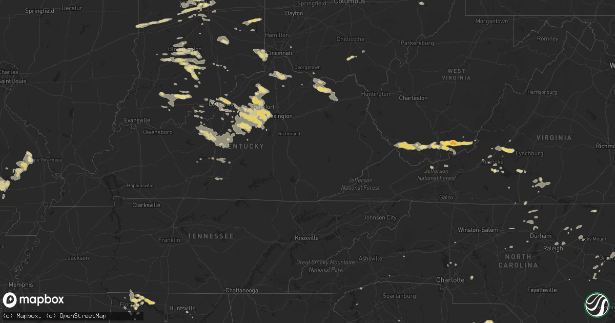
Hail Map in Kentucky on July 27, 2012
Get this storm
July 27 map
$229
one time, instant access
Download today. No call, no setup
Keep the $229
Bought the map and want the full workflow? Apply the entire $229 to a subscription within 7 days. None of it is wasted.
Every map, not just this one
This buys you this map. Subscription and you get every map we run, in the markets you choose from a few cities to whole states to nationwide. Plus real-time alerts the moment a storm fires.
Contact data
Name, contact info, occupancy, even credit band for addresses in the footprint. You go from where it hit to who to call.
Become the source they trust
Unlimited branding weather history reports on demand. You already have the documented answer ready for the property owner, and you are the one who showed up with it.
Property data and RoofTrace estimates
Pull up any address you have got, its value and the exact code rules for that jurisdiction, straight from One Click Code. Then RoofTrace estimates the squares, pitch, and roof value, priced the way you price.
Storm reports in Kentucky
Kentucky
| Date | Description |
|---|---|
| 07/27/20126:51 PM CDT | Trees down on taylor mill road. |
| 07/27/20126:51 PM CDT | Trees down in bethel. |
| 07/27/20126:50 PM CDT | Trees down with some on cars on mockingbird lane...high street...ky 36 on railroad tracks...ox bow road...and locust grove road |
| 07/27/20126:49 PM CDT | Trees down on fleming road. |
| 07/27/20126:46 PM CDT | Trees down on elizaville road. |
| 07/27/20126:46 PM CDT | Multiple reports of widespread trees and power lines down making roads impassable including in the thornhill area |
| 07/27/20126:40 PM CDT | Trees and power lines reported down |
| 07/27/20126:37 PM CDT | Large tree fell on a house on nole ave |
| 07/27/20126:36 PM CDT | Spotter reports quarter size hail |
| 07/27/20126:30 PM CDT | Quarter size hail reported near westport and goose creek road |
| 07/27/20126:28 PM CDT | Report of quarter size hail in rolling hills via facebook |
| 07/27/20126:26 PM CDT | Numerous trees down near cynthiana |
| 07/27/20126:25 PM CDT | Tree down on power line. Reported through facebook. |
| 07/27/20126:24 PM CDT | Trees down on clore jackson road |
| 07/27/20126:19 PM CDT | Half of a maple tree down on power lines about 1 mile east of ballard hs |
| 07/27/20126:10 PM CDT | A few trees down |
| 07/27/20125:55 PM CDT | Several trees down |
| 07/27/20125:42 PM CDT | Tree down on dawkins road |
| 07/27/20125:42 PM CDT | Tree down on westport and highway 524 |
| 07/27/20125:22 PM CDT | A local report indicates 62 MPH wind near CARROLLTON |
| 07/27/20125:17 PM CDT | 12 inch diameter tree down |
| 07/27/20125:06 PM CDT | Partial roof ripped off of a garage on culls ridge road near bedford |
| 07/27/20125:02 PM CDT | Tree reported down on race track road in the milton area |
| 07/27/20124:25 PM CDT | Shingles torn off a roof near kentucky route 16 in taylor mill. Numerous trees down in the area. |
| 07/27/20124:14 PM CDT | Several trees down. |
| 07/27/20124:08 PM CDT | Large trees down |
| 07/27/201211:11 AM CDT | Powerlines down near conley bottom resort. |
| 07/27/201211:05 AM CDT | Tree down on denny lane. |
| 07/26/201211:11 PM CDT | Powerlines down near conley bottom resort. |
| 07/26/201211:05 PM CDT | Tree down on denny lane. |
| 07/26/201210:57 PM CDT | Trees down on highway 196. |
| 07/26/201210:50 PM CDT | Reports called into local radio station of trees down in the salem community...approx. 5 east of russell springs |
| 07/26/201210:44 PM CDT | Trees down on highway 635. |
| 07/26/201210:26 PM CDT | Trees down across power lines. |
| 07/26/201210:15 PM CDT | Power lines down on hord street |
| 07/26/201210:13 PM CDT | Dispatch reports trees down |
| 07/26/201210:10 PM CDT | Dispatch reports tree blocking road in bengal |
| 07/26/20129:41 PM CDT | Dispatch reports trees down across the county |
| 07/26/20129:37 PM CDT | Trees and power lines down |
| 07/26/20129:26 PM CDT | Tree down and partially blocking springfield road. |
| 07/26/20129:23 PM CDT | Tree down |
| 07/26/20129:11 PM CDT | Tree down on a home |
| 07/26/20129:10 PM CDT | Tree down on a house... Temporarily trapping a person inside in the henderson woods subdivision. |
| 07/26/20128:44 PM CDT | Trees down at 4400 waddy road |
| 07/26/20128:32 PM CDT | Large portion of tree down in eastern spencer county... Time and location estimated |
| 07/26/20128:27 PM CDT | Dispatch reports trees down near knob creek road and ky 44 w along with a blown transformer |
| 07/26/20128:18 PM CDT | Dispatch reports tree down with power outages |
| 07/26/20128:15 PM CDT | A local report indicates 60 MPH wind near LOUISA |
| 07/26/20128:15 PM CDT | Trees down on little mud lick road. |
| 07/26/20128:03 PM CDT | Trees down on hwy 1092. |
| 07/26/20127:58 PM CDT | Trees down on hwy 469. |
| 07/26/20127:57 PM CDT | A local report indicates 1.00 inch wind near GRAYSON |
| 07/26/20127:50 PM CDT | Large branches broken. |
| 07/26/20127:45 PM CDT | Reports of numerous trees down as well as power outages in anderson county |
| 07/26/20127:40 PM CDT | 18 tree down on u.s. 62 near wild turkey trace |
| 07/26/20127:40 PM CDT | Numerous trees down around olive hill...reports of power outages as well |
| 07/26/20127:36 PM CDT | Lex reported 57 knot gust |
| 07/26/20127:35 PM CDT | Tops of a pine tree and sycamore tree were broken off. |
| 07/26/20127:35 PM CDT | One tree down on hwy 460. |
| 07/26/20127:35 PM CDT | Numerous trees down on route 60 around the town of globe |
| 07/26/20127:31 PM CDT | A local report indicates 65 MPH wind near 1 N LAWRENCEBURG |
| 07/26/20127:31 PM CDT | Telephone poles reported down along with blown transformers near i-65 |
| 07/26/20127:30 PM CDT | Large treen down on highway 504 near gimlet. |
| 07/26/20127:30 PM CDT | Trees down on highways 519 and 1002. |
| 07/26/20127:26 PM CDT | Northeast ymca reports destroyed greenhouse and two large downed trees |
| 07/26/20127:23 PM CDT | Trees down on dry creek road. |
| 07/26/20127:21 PM CDT | Trees down on us 60 near rowan and carter county line. |
| 07/26/20127:18 PM CDT | Trees down on highway 377. |
| 07/26/20127:10 PM CDT | Trees down in salt lick. |
| 07/26/20127:00 PM CDT | Trees down on ringos mills road. |
| 07/26/20127:00 PM CDT | Trees down on day road. |
All States Impacted by Hail Map on July 27, 2012
Cities Impacted by Hail Map on July 27, 2012
- Hartsville, SC
- Darlington, SC
- McBee, SC
- Patrick, SC
- Society Hill, SC
- Louisville, KY
- Lizton, IN
- North Salem, IN
- Hinton, WV
- Jumping Branch, WV
- Pipestem, WV
- Owenton, KY
- Celestine, IN
- Birdseye, IN
- Taswell, IN
- Eckerty, IN
- Columbus, IN
- Nashville, IN
- Howell, MI
- Perry, MI
- Byron, MI
- Webberville, MI
- Morrice, MI
- Williamston, MI
- Fowlerville, MI
- Magnolia, KY
- Summersville, KY
- Petersburg, KY
- Aurora, IN
- Lawrenceburg, IN
- Burlington, KY
- Henderson, MI
- Bannister, MI
- Oakley, MI
- Chesaning, MI
- Elsie, MI
- Fort Wayne, IN
- Hoagland, IN
- Ossian, IN
- Yoder, IN
- Decatur, IN
- Brighton, MI
- Central, IN
- Mauckport, IN
- Corydon, IN
- Claxton, GA
- Leopold, MO
- Whitewater, MO
- Marble Hill, MO
- Burfordville, MO
- Bloomfield, IN
- Trafalgar, IN
- Beech Grove, IN
- Indianapolis, IN
- Nathalie, VA
- Moores Hill, IN
- Rising Sun, IN
- Guilford, IN
- Cecilia, KY
- Vine Grove, KY
- Elizabethtown, KY
- Rineyville, KY
- Montvale, VA
- Baconton, GA
- Bremen, IN
- Oneonta, AL
- Rocky Gap, VA
- Bastian, VA
- Yemassee, SC
- Green Pond, SC
- Seabrook, SC
- Lockport, KY
- Lamont, FL
- Killen, AL
- Lexington, AL
- North Spring, WV
- Ikes Fork, WV
- Iaeger, WV
- Gilbert, WV
- Baisden, WV
- Davy, WV
- Mohawk, WV
- Wichita Falls, TX
- Burkburnett, TX
- Kadoka, SD
- Fort Mitchell, AL
- Sadler, TX
- Sherman, TX
- Whitesboro, TX
- Gadsden, AL
- Seven Springs, NC
- Breckenridge, MI
- Elwell, MI
- Merrill, MI
- Ithaca, MI
- Wheeler, MI
- Riverdale, MI
- Saint Louis, MI
- Saint Charles, MI
- Sumner, MI
- Alma, MI
- Willisburg, KY
- Bloomfield, KY
- Whitestown, IN
- Westfield, IN
- Carmel, IN
- Zionsville, IN
- Bluffton, SC
- Poplar Bluff, MO
- Wappapello, MO
- Monticello, GA
- Mansfield, GA
- Seymour, IN
- Millington, MI
- Fostoria, MI
- Flora, IN
- Wayside, WV
- Ballard, WV
- Talcott, WV
- Forest Hill, WV
- Greenville, WV
- Camden, MI
- Montgomery, MI
- Pioneer, OH
- Montpelier, OH
- Edon, OH
- Saint Louisville, OH
- Utica, OH
- Florence, AL
- Milford, MI
- Wixom, MI
- New Hudson, MI
- Novi, MI
- Walled Lake, MI
- South Lyon, MI
- Commerce Township, MI
- Lawrenceburg, KY
- Frankfort, KY
- Versailles, KY
- Grafton, OH
- Litchfield, OH
- Danville, IN
- Brownsburg, IN
- Tuscumbia, AL
- Muscle Shoals, AL
- Leighton, AL
- Noblesville, IN
- Shepherdsville, KY
- Owosso, MI
- Greensburg, IN
- Hope, IN
- Hartsville, IN
- Shelbyville, KY
- Varnville, SC
- Hampton, SC
- Luray, SC
- Brunson, SC
- New Paris, IN
- Wagener, SC
- Franklin, GA
- Fitzgerald, GA
- Louisville, MS
- Moultrie, GA
- Hartsfield, GA
- Meigs, GA
- Claudville, VA
- Hodgenville, KY
- Hardy, VA
- Roanoke, VA
- Missoula, MT
- Rozet, WY
- Wall, SD
- Wasta, SD
- Roanoke Rapids, NC
- Ellettsville, IN
- Gosport, IN
- Bloomington, IN
- Bland, VA
- Orleans, IN
- Glasgow, KY
- Edmonton, KY
- Carbon, IN
- Rosedale, IN
- Dry Ridge, KY
- Midkiff, TX
- Springfield, KY
- Manchester, MI
- English, IN
- Herndon, WV
- Pineville, WV
- Natural Bridge Station, VA
- Natural Bridge, VA
- Harrodsburg, KY
- Taylorsville, KY
- Waddy, KY
- Mount Eden, KY
- Salvisa, KY
- Marion, MT
- Delta, OH
- Swanton, OH
- Tuthill, SD
- Saint Francis, SD
- Merriman, NE
- Cody, NE
- Coopersville, MI
- Ravenna, MI
- Dixon, MT
- Pineland, SC
- Garnett, SC
- Odd, WV
- Flat Top, WV
- Camp Creek, WV
- Pleasureville, KY
- Bagdad, KY
- Terre Haute, IN
- McGee, MO
- Advance, MO
- Gipsy, MO
- Puxico, MO
- Millersville, MO
- Zalma, MO
- Sturdivant, MO
- Glenallen, MO
- Wirtz, VA
- Boones Mill, VA
- Atlanta, IN
- Moorcroft, WY
- Senecaville, OH
- Greenville, NC
- Moneta, VA
- Campbellsburg, IN
- Williamsville, MO
- Rossford, OH
- Perrysburg, OH
- Liberty, IN
- Brownsville, IN
- Connersville, IN
- Bedford, IN
- Edmore, MI
- Six Lakes, MI
- Stanton, MI
- Lakeview, MI
- Mitchell, IN
- Heltonville, IN
- Tunnelton, IN
- Piedmont, SD
- Sheridan, IN
- Cicero, IN
- Tipton, IN
- Arcadia, IN
- Blakely, GA
- Macon, MS
- Brookwood, AL
- Hanover, WV
- Athens, WV
- Nimitz, WV
- New Richmond, WV
- Josephine, WV
- Hurley, VA
- Wyoming, WV
- Panther, WV
- Stephenson, WV
- Ghent, WV
- Union, WV
- Spanishburg, WV
- Gap Mills, WV
- Fanrock, WV
- Welch, WV
- Wolfcreek, WV
- Lerona, WV
- Princeton, WV
- Lashmeet, WV
- Matoaka, WV
- Wharncliffe, WV
- Peterstown, WV
- Snow Hill, NC
- Flemingsburg, KY
- Tollesboro, KY
- Wallingford, KY
- Lakeside, MT
- Wilsonville, AL
- Anaconda, MT
- Fort Stockton, TX
- Salley, SC
- Siler City, NC
- Staley, NC
- Nocona, TX
- Sandersville, GA
- Brooksville, MS
- Stokes, NC
- Southgate, MI
- Ripley, OH
- Rogersville, AL
- Ashville, AL
- Woodbury, GA
- Finchville, KY
- Fisherville, KY
- Simpsonville, KY
- Waynesboro, GA
- Maysville, KY
- Aberdeen, OH
- Morehead, KY
- Manchester, OH
- Olive Hill, KY
- Vanceburg, KY
- Emerson, KY
- Weston, WY
- Stilesville, IN
- Coatesville, IN
- Fillmore, IN
- Kokomo, IN
- Ocilla, GA
- Chappells, SC
- Saluda, SC
- Saint Ignatius, MT
- Toomsboro, GA
- Alex, OK
- Bradley, OK
- La Grange, NC
- Chadron, NE
- Oelrichs, SD
- Cornelius, NC
- Griffin, GA
- Youngsville, PA
- Sugar Grove, PA
- Commiskey, IN
- Louisville, AL
- Clayton, AL
- Holden, LA
- De Mossville, KY
- Falmouth, KY
- Butler, KY
- Williamstown, KY
- Crittenden, KY
- Salem, VA
- French Lick, IN
- Greensburg, KY
- Walstonburg, NC
- Bedford, VA
- Buchanan, VA
- Springville, IN
- Paris, IL
- West Terre Haute, IN
- New Goshen, IN
- Georgetown, IN
- Greenville, IN
- New Salisbury, IN
- Ninnekah, OK
- Chickasha, OK
- Greencastle, IN
- Brazil, IN
- Sturgis, SD
- Athens, AL
- Jasper, IN
- Otwell, IN
- Shoals, IN
- Crookston, NE
- Cuthbert, GA
- Littleton, NC
- Hodges, SC
- Aliceville, AL
- Carrollton, AL
- Newnan, GA
- Lena, MS
- Bethune, SC
- Mount Washington, KY
- Owanka, SD
- New Underwood, SD
- Butte, MT
- Pelion, SC
- Danville, VA
- Hillsborough, NC
- Rougemont, NC
- Wilson, OK
- Piketon, OH
- Greenwood, IN
- Gillette, WY
- Jeffersonville, IN
- Sellersburg, IN
- Clarksville, IN
- Brownstown, IN
- Vallonia, IN
- Owensburg, IN
- Freetown, IN
- Avoca, IN
- Medora, IN
- Norman, IN
- Oolitic, IN
- Lyons, IN
- Clinton, SC
- Laurens, SC
- Bethlehem, KY
- Marysville, IN
- Sweeden, KY
- Farmville, NC
- Continental, OH
- Grosse Ile, MI
- Bardstown, KY
- Boston, KY
- Saint Jo, TX
- Central, SC
- Six Mile, SC
- Fortson, GA
- New Hope, KY
- Irvington, KY
- Sonora, KY
- Glendale, KY
- New Haven, KY
- Guston, KY
- Buffalo, KY
- Radcliff, KY
- Ekron, KY
- Custer, KY
- Loretto, TN
- Lawrenceburg, TN
- Decatur, AL
- Okatie, SC
- Milford, OH
- Healdton, OK
- Locust Grove, GA
- Gretna, VA
- Hurt, VA
- Lynch Station, VA
- Harrisburg, NE
- Osseo, MI
- Waldron, MI
- Alvordton, OH
- Power, MT
- Mill Creek, OK
- Sulphur, OK
- Jackson, GA
- Jenkinsburg, GA
- Hardeeville, SC
- Mountville, SC
- Nemo, SD
- Waverly, OH
- Beaver, OH
- Crestview, FL
- Defuniak Springs, FL
- Saline, MI
- Ottawa, OH
- Cloverdale, OH
- Groveoak, AL
- Owens Cross Roads, AL
- Oakboro, NC
- Lagrange, OH
- Iron City, TN
- Sheffield, AL
- Laingsburg, MI
- Bancroft, MI
- Pennington, AL
- Wauseon, OH
- Smiths Station, AL
- Phenix City, AL
- Durand, MI
- Bigfork, MT
- Midway, KY
- Coxs Creek, KY
- Worthville, KY
- Fairfield, KY
- Chaplin, KY
- New Liberty, KY
- Eminence, KY
- Brant, MI
- Nederland, CO
- Shepherd, MI
- Philadelphia, MS
- Jackson, OH
- Ray, OH
- Troutville, VA
- Fincastle, VA
- Roff, OK
- Boaz, AL
- Horton, AL
- Vale, SD
- Genoa, OH
- Elmore, OH
- Graytown, OH
- Woodville, OH
- Martin, OH
- Elwood, IN
- Brandenburg, KY
- Laconia, IN
- Glenview, KY
- Masonic Home, KY
- New Albany, IN
- Prospect, KY
- Paoli, IN
- Howe, TX
- Collinsville, TX
- Plains, GA
- West Blocton, AL
- Bunker Hill, IN
- Peru, IN
- Mayville, MI
- Russellville, AL
- Vassar, MI
- Ringgold, VA
- Altoona, AL
- New Hope, AL
- Sinks Grove, WV
- Salem, AL
- Lowell, MI
- Galveston, IN
- Walton, IN
- Ada, MI
- Keenesburg, CO
- Lapel, IN
- Golden, CO
- Madison, GA
- Eatonton, GA
- Charlo, MT
- Fortville, IN
- Pittsboro, IN
- Fishers, IN
- Mccordsville, IN
- Avon, IN
- Nashville, NC
- Berry, KY
- Windsor, SC
- Aiken, SC
- Glenwood, IN
- Oakwood, OH
- Rollins, MT
- Proctor, MT
- Forest, MS
- Pittsview, AL
- Java, VA
- Vernon Hill, VA
- Russiaville, IN
- Forest, IN
- Sharpsville, IN
- Kempton, IN
- McKenzie, AL
- Old Appleton, MO
- Leoma, TN
- Ferdinand, IN
- Battletown, KY
- Huntingburg, IN
- Holland, IN
- Dale, IN
- Salem, IN
- Newton Grove, NC
- Mount Olive, NC
- Zebulon, NC
- Wendell, NC
- Knightdale, NC
- Milton, FL
- Foster, KY
- Floyds Knobs, IN
- Raleigh, NC
- Nappanee, IN
- Goshen, IN
- Wakarusa, IN
- Stanfield, NC
- Locust, NC
- Monroeville, AL
- Lebanon, IN
- Jamestown, IN
- Chapel Hill, NC
- Ninety Six, SC
- Brownsboro, AL
- Alton, VA
- Milton, NC
- Sutherlin, VA
- Prospect Hill, NC
- Hurdle Mills, NC
- Cedar Grove, NC
- Lauderdale, MS
- Ridgeland, SC
- Laurel Hill, FL
- Munfordville, KY
- Bonnieville, KY
- Solsberry, IN
- Register, GA
- Paris Crossing, IN
- McCamey, TX
- Valier, MT
- Browning, MT
- Quinn, SD
- Ionia, MI
- Lyons, MI
- Pewamo, MI
- Linton, IN
- Plainfield, IN
- Spencer, IN
- Orleans, MI
- Milan, IN
- North Bend, OH
- Sunman, IN
- Laurel, IN
- Metamora, IN
- Brookville, IN
- Mammoth Cave, KY
- Cub Run, KY
- Crystal Hill, VA
- Scottsburg, VA
- Clover, VA
- Halifax, VA
- Randolph, VA
- Hemlock, MI
- Ligonier, IN
- Syracuse, IN
- Millersburg, IN
- Mission, SD
- Springville, AL
- Charlestown, IN
- Avon Lake, OH
- Sheffield Lake, OH
- Eutaw, AL
- Lucasville, OH
- Rushville, IN
- Petrolia, TX
- Parrott, GA
- Liberty, NC
- Ramseur, NC
- Franklinville, NC
- Gurley, AL
- Statesville, NC
- Mount Olivet, KY
- Louisburg, NC
- Franklinton, NC
- Guntersville, AL
- Moulton, AL
- South Boston, VA
- Galion, OH
- Castalia, NC
- Kalispell, MT
- Wellington, OH
- Clyo, GA
- Cut Bank, MT
- Kendallville, IN
- Milroy, IN
- Shellman, GA
- Velpen, IN
- Dubois, IN
- Schnellville, IN
- Saint Anthony, IN
- Marengo, IN
- Brevard, NC
- Altavista, VA
- Tifton, GA
- Hardyville, KY
- Canmer, KY
- Cleveland, AL
- Blountsville, AL
- Cedartown, GA
- Gibsonville, NC
- Elon, NC
- Burlington, NC
- Sulligent, AL
- Vernon, AL
- Bargersville, IN
- Greenfield, IN
- New Palestine, IN
- Spring Hope, NC
- Lucedale, MS
- Mill Spring, NC
- Timberlake, NC
- Roxboro, NC
- Leasburg, NC
- Waterloo, SC
- Pooler, GA
- Callands, VA
- Chatham, VA
- Big Lake, TX
- Neelyville, MO
- Thomson, GA
- Bethel, NC
- Northville, MI
- Mebane, NC
- Ashley, MI
- Hilton Head Island, SC
- Vinton, VA
- Covington, GA
- Geraldine, AL
- Henrietta, TX
- Snover, MI
- Sandusky, MI
- White Pigeon, MI
- Bennett, CO
- Topeka, IN
- Midway, AL
- Greenville, MO
- Worthington, IN
- Millport, AL
- Lyons, OH
- Fayette, OH
- Lanesville, IN
- Mooresville, NC
- Beaverton, AL
- Morganton, NC
- Nebo, NC
- Flat Rock, IN
- Sharpsburg, GA
- Deputy, IN
- Payneville, KY
- Florala, AL
- Kannapolis, NC
- Davidson, NC
- Concord, NC
- New Boston, MI
- Early Branch, SC
- Canton, MS
- Camden, MS


