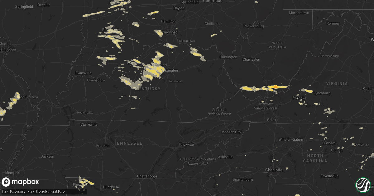
Hail Map in Indiana on July 27, 2012
Get this storm
July 27 map
$229
one time, instant access
Download today. No call, no setup
Keep the $229
Bought the map and want the full workflow? Apply the entire $229 to a subscription within 7 days. None of it is wasted.
Every map, not just this one
This buys you this map. Subscription and you get every map we run, in the markets you choose from a few cities to whole states to nationwide. Plus real-time alerts the moment a storm fires.
Contact data
Name, contact info, occupancy, even credit band for addresses in the footprint. You go from where it hit to who to call.
Become the source they trust
Unlimited branding weather history reports on demand. You already have the documented answer ready for the property owner, and you are the one who showed up with it.
Property data and RoofTrace estimates
Pull up any address you have got, its value and the exact code rules for that jurisdiction, straight from One Click Code. Then RoofTrace estimates the squares, pitch, and roof value, priced the way you price.
Storm reports in Indiana
Indiana
| Date | Description |
|---|---|
| 07/27/20126:55 PM CDT | Tree down |
| 07/27/20126:54 PM CDT | Dispatch reports trees down in northeastern jasper |
| 07/27/20126:50 PM CDT | Tree reported down in backyard via facebook |
| 07/27/20126:22 PM CDT | Dispatch reports a few trees down near campbellsburg |
| 07/27/20126:05 PM CDT | Several trees downed in the tunnelton and fort ritner areas. |
| 07/27/20125:31 PM CDT | Tree limbs of about a foot in diameter down and a roof came off of a shed |
| 07/27/20125:27 PM CDT | Tree down at 5600 split stump road in lexington... In. |
| 07/27/20125:27 PM CDT | Report of 8 inch diameter tree limb on house |
| 07/27/20125:21 PM CDT | Spotter called in report of estimated 60 to 65 mph winds with shingles coming off of roof |
| 07/27/20125:10 PM CDT | Partial metal roof ripped off |
| 07/27/20125:05 PM CDT | A local report indicates 60 MPH wind near BEDFORD |
| 07/27/20125:05 PM CDT | A local report indicates 1.00 inch wind near BEDFORD |
| 07/27/20125:03 PM CDT | Trees down on east main street in austin. |
| 07/27/20124:52 PM CDT | Trees down on north street in austin. |
| 07/27/20124:50 PM CDT | Twenty trees downed from paris crossing to sr7 in southeast part of county. |
| 07/27/20124:43 PM CDT | Trees reported down on state road 7 as well as other trees and power lines down on the north and eastern portions of the county |
| 07/27/20124:40 PM CDT | Two trees snapped in half |
| 07/27/20124:36 PM CDT | Spotter reports lots of large tree limbs down |
| 07/27/20124:33 PM CDT | Spotter estimates wind gust of 60 mph... Wind gust destroyed anemometer |
| 07/27/20124:30 PM CDT | Part of a roof peeled off at the hillcrest shops strip mall near the intersection of state route 37 and sieboldt quarry road in judan. |
| 07/27/20124:30 PM CDT | A local report indicates 60 MPH wind near HARRODSBURG |
| 07/27/20124:26 PM CDT | Transformer blown off utility pole and on fire. Railroad crossing arms broken off on u.s. 50. Numerous traffic lights and trees broken. All these reports verified as be |
| 07/27/20124:25 PM CDT | Three inch diameter tree limbs down |
| 07/27/20124:23 PM CDT | Six to eight diameter tree down on west 2nd street. Pea size hail. |
| 07/27/20124:22 PM CDT | 50 foot dead tree blown down |
| 07/27/20124:20 PM CDT | A local report indicates 60 MPH wind near BROWNSTOWN |
| 07/27/20124:00 PM CDT | Smashed corn crib and large tree uprooted. |
| 07/27/20123:52 PM CDT | 3 semi trucks overturned on i-275 |
| 07/27/20123:35 PM CDT | Twelve inch diameter tree snapped off at base near intersection of north hartstrait road and ratliff road |
| 07/27/20123:15 PM CDT | A local report indicates 1.25 inch wind near 3 SW FISHERS |
| 07/27/20123:15 PM CDT | Time estimated from radar. Late report. |
| 07/27/20123:15 PM CDT | Several trees toppled |
| 07/27/20123:14 PM CDT | Quarter size hail reported at 96th and meridian on hamilton and marion county line. Late report. |
| 07/27/20123:10 PM CDT | From spotternetwork. Most hailstones were half inch. |
| 07/27/20123:09 PM CDT | On sr37 just north of town. |
| 07/27/20122:55 PM CDT | Several large trees down. Part of roofing removed from business. Billboard blown down. |
| 07/27/20122:50 PM CDT | Estimated wind gust of 55-60 mph |
| 07/27/20122:47 PM CDT | A local report indicates 1.00 inch wind near BROWNSBURG |
| 07/27/20122:45 PM CDT | Several trees downed in the burney area near cr100s and cr850w. |
| 07/27/20122:20 PM CDT | Several trees downed in madison township. |
| 07/27/20121:55 PM CDT | Several trees downed just southeast of town. |
| 07/27/20121:35 PM CDT | Also quarter size hail and tree limb damage. |
| 07/27/20121:20 PM CDT | Numerous reports of transformer and power lines down and trees down around the flora area. Roof off a chicken coop blown off. No power in flora at time. Time of transfo |
| 07/26/20127:17 PM CDT | Dispatch reports tree down |
All States Impacted by Hail Map on July 27, 2012
Cities Impacted by Hail Map on July 27, 2012
- Hartsville, SC
- Darlington, SC
- McBee, SC
- Patrick, SC
- Society Hill, SC
- Louisville, KY
- Lizton, IN
- North Salem, IN
- Hinton, WV
- Jumping Branch, WV
- Pipestem, WV
- Owenton, KY
- Celestine, IN
- Birdseye, IN
- Taswell, IN
- Eckerty, IN
- Columbus, IN
- Nashville, IN
- Howell, MI
- Perry, MI
- Byron, MI
- Webberville, MI
- Morrice, MI
- Williamston, MI
- Fowlerville, MI
- Magnolia, KY
- Summersville, KY
- Petersburg, KY
- Aurora, IN
- Lawrenceburg, IN
- Burlington, KY
- Henderson, MI
- Bannister, MI
- Oakley, MI
- Chesaning, MI
- Elsie, MI
- Fort Wayne, IN
- Hoagland, IN
- Ossian, IN
- Yoder, IN
- Decatur, IN
- Brighton, MI
- Central, IN
- Mauckport, IN
- Corydon, IN
- Claxton, GA
- Leopold, MO
- Whitewater, MO
- Marble Hill, MO
- Burfordville, MO
- Bloomfield, IN
- Trafalgar, IN
- Beech Grove, IN
- Indianapolis, IN
- Nathalie, VA
- Moores Hill, IN
- Rising Sun, IN
- Guilford, IN
- Cecilia, KY
- Vine Grove, KY
- Elizabethtown, KY
- Rineyville, KY
- Montvale, VA
- Baconton, GA
- Bremen, IN
- Oneonta, AL
- Rocky Gap, VA
- Bastian, VA
- Yemassee, SC
- Green Pond, SC
- Seabrook, SC
- Lockport, KY
- Lamont, FL
- Killen, AL
- Lexington, AL
- North Spring, WV
- Ikes Fork, WV
- Iaeger, WV
- Gilbert, WV
- Baisden, WV
- Davy, WV
- Mohawk, WV
- Wichita Falls, TX
- Burkburnett, TX
- Kadoka, SD
- Fort Mitchell, AL
- Sadler, TX
- Sherman, TX
- Whitesboro, TX
- Gadsden, AL
- Seven Springs, NC
- Breckenridge, MI
- Elwell, MI
- Merrill, MI
- Ithaca, MI
- Wheeler, MI
- Riverdale, MI
- Saint Louis, MI
- Saint Charles, MI
- Sumner, MI
- Alma, MI
- Willisburg, KY
- Bloomfield, KY
- Whitestown, IN
- Westfield, IN
- Carmel, IN
- Zionsville, IN
- Bluffton, SC
- Poplar Bluff, MO
- Wappapello, MO
- Monticello, GA
- Mansfield, GA
- Seymour, IN
- Millington, MI
- Fostoria, MI
- Flora, IN
- Wayside, WV
- Ballard, WV
- Talcott, WV
- Forest Hill, WV
- Greenville, WV
- Camden, MI
- Montgomery, MI
- Pioneer, OH
- Montpelier, OH
- Edon, OH
- Saint Louisville, OH
- Utica, OH
- Florence, AL
- Milford, MI
- Wixom, MI
- New Hudson, MI
- Novi, MI
- Walled Lake, MI
- South Lyon, MI
- Commerce Township, MI
- Lawrenceburg, KY
- Frankfort, KY
- Versailles, KY
- Grafton, OH
- Litchfield, OH
- Danville, IN
- Brownsburg, IN
- Tuscumbia, AL
- Muscle Shoals, AL
- Leighton, AL
- Noblesville, IN
- Shepherdsville, KY
- Owosso, MI
- Greensburg, IN
- Hope, IN
- Hartsville, IN
- Shelbyville, KY
- Varnville, SC
- Hampton, SC
- Luray, SC
- Brunson, SC
- New Paris, IN
- Wagener, SC
- Franklin, GA
- Fitzgerald, GA
- Louisville, MS
- Moultrie, GA
- Hartsfield, GA
- Meigs, GA
- Claudville, VA
- Hodgenville, KY
- Hardy, VA
- Roanoke, VA
- Missoula, MT
- Rozet, WY
- Wall, SD
- Wasta, SD
- Roanoke Rapids, NC
- Ellettsville, IN
- Gosport, IN
- Bloomington, IN
- Bland, VA
- Orleans, IN
- Glasgow, KY
- Edmonton, KY
- Carbon, IN
- Rosedale, IN
- Dry Ridge, KY
- Midkiff, TX
- Springfield, KY
- Manchester, MI
- English, IN
- Herndon, WV
- Pineville, WV
- Natural Bridge Station, VA
- Natural Bridge, VA
- Harrodsburg, KY
- Taylorsville, KY
- Waddy, KY
- Mount Eden, KY
- Salvisa, KY
- Marion, MT
- Delta, OH
- Swanton, OH
- Tuthill, SD
- Saint Francis, SD
- Merriman, NE
- Cody, NE
- Coopersville, MI
- Ravenna, MI
- Dixon, MT
- Pineland, SC
- Garnett, SC
- Odd, WV
- Flat Top, WV
- Camp Creek, WV
- Pleasureville, KY
- Bagdad, KY
- Terre Haute, IN
- McGee, MO
- Advance, MO
- Gipsy, MO
- Puxico, MO
- Millersville, MO
- Zalma, MO
- Sturdivant, MO
- Glenallen, MO
- Wirtz, VA
- Boones Mill, VA
- Atlanta, IN
- Moorcroft, WY
- Senecaville, OH
- Greenville, NC
- Moneta, VA
- Campbellsburg, IN
- Williamsville, MO
- Rossford, OH
- Perrysburg, OH
- Liberty, IN
- Brownsville, IN
- Connersville, IN
- Bedford, IN
- Edmore, MI
- Six Lakes, MI
- Stanton, MI
- Lakeview, MI
- Mitchell, IN
- Heltonville, IN
- Tunnelton, IN
- Piedmont, SD
- Sheridan, IN
- Cicero, IN
- Tipton, IN
- Arcadia, IN
- Blakely, GA
- Macon, MS
- Brookwood, AL
- Hanover, WV
- Athens, WV
- Nimitz, WV
- New Richmond, WV
- Josephine, WV
- Hurley, VA
- Wyoming, WV
- Panther, WV
- Stephenson, WV
- Ghent, WV
- Union, WV
- Spanishburg, WV
- Gap Mills, WV
- Fanrock, WV
- Welch, WV
- Wolfcreek, WV
- Lerona, WV
- Princeton, WV
- Lashmeet, WV
- Matoaka, WV
- Wharncliffe, WV
- Peterstown, WV
- Snow Hill, NC
- Flemingsburg, KY
- Tollesboro, KY
- Wallingford, KY
- Lakeside, MT
- Wilsonville, AL
- Anaconda, MT
- Fort Stockton, TX
- Salley, SC
- Siler City, NC
- Staley, NC
- Nocona, TX
- Sandersville, GA
- Brooksville, MS
- Stokes, NC
- Southgate, MI
- Ripley, OH
- Rogersville, AL
- Ashville, AL
- Woodbury, GA
- Finchville, KY
- Fisherville, KY
- Simpsonville, KY
- Waynesboro, GA
- Maysville, KY
- Aberdeen, OH
- Morehead, KY
- Manchester, OH
- Olive Hill, KY
- Vanceburg, KY
- Emerson, KY
- Weston, WY
- Stilesville, IN
- Coatesville, IN
- Fillmore, IN
- Kokomo, IN
- Ocilla, GA
- Chappells, SC
- Saluda, SC
- Saint Ignatius, MT
- Toomsboro, GA
- Alex, OK
- Bradley, OK
- La Grange, NC
- Chadron, NE
- Oelrichs, SD
- Cornelius, NC
- Griffin, GA
- Youngsville, PA
- Sugar Grove, PA
- Commiskey, IN
- Louisville, AL
- Clayton, AL
- Holden, LA
- De Mossville, KY
- Falmouth, KY
- Butler, KY
- Williamstown, KY
- Crittenden, KY
- Salem, VA
- French Lick, IN
- Greensburg, KY
- Walstonburg, NC
- Bedford, VA
- Buchanan, VA
- Springville, IN
- Paris, IL
- West Terre Haute, IN
- New Goshen, IN
- Georgetown, IN
- Greenville, IN
- New Salisbury, IN
- Ninnekah, OK
- Chickasha, OK
- Greencastle, IN
- Brazil, IN
- Sturgis, SD
- Athens, AL
- Jasper, IN
- Otwell, IN
- Shoals, IN
- Crookston, NE
- Cuthbert, GA
- Littleton, NC
- Hodges, SC
- Aliceville, AL
- Carrollton, AL
- Newnan, GA
- Lena, MS
- Bethune, SC
- Mount Washington, KY
- Owanka, SD
- New Underwood, SD
- Butte, MT
- Pelion, SC
- Danville, VA
- Hillsborough, NC
- Rougemont, NC
- Wilson, OK
- Piketon, OH
- Greenwood, IN
- Gillette, WY
- Jeffersonville, IN
- Sellersburg, IN
- Clarksville, IN
- Brownstown, IN
- Vallonia, IN
- Owensburg, IN
- Freetown, IN
- Avoca, IN
- Medora, IN
- Norman, IN
- Oolitic, IN
- Lyons, IN
- Clinton, SC
- Laurens, SC
- Bethlehem, KY
- Marysville, IN
- Sweeden, KY
- Farmville, NC
- Continental, OH
- Grosse Ile, MI
- Bardstown, KY
- Boston, KY
- Saint Jo, TX
- Central, SC
- Six Mile, SC
- Fortson, GA
- New Hope, KY
- Irvington, KY
- Sonora, KY
- Glendale, KY
- New Haven, KY
- Guston, KY
- Buffalo, KY
- Radcliff, KY
- Ekron, KY
- Custer, KY
- Loretto, TN
- Lawrenceburg, TN
- Decatur, AL
- Okatie, SC
- Milford, OH
- Healdton, OK
- Locust Grove, GA
- Gretna, VA
- Hurt, VA
- Lynch Station, VA
- Harrisburg, NE
- Osseo, MI
- Waldron, MI
- Alvordton, OH
- Power, MT
- Mill Creek, OK
- Sulphur, OK
- Jackson, GA
- Jenkinsburg, GA
- Hardeeville, SC
- Mountville, SC
- Nemo, SD
- Waverly, OH
- Beaver, OH
- Crestview, FL
- Defuniak Springs, FL
- Saline, MI
- Ottawa, OH
- Cloverdale, OH
- Groveoak, AL
- Owens Cross Roads, AL
- Oakboro, NC
- Lagrange, OH
- Iron City, TN
- Sheffield, AL
- Laingsburg, MI
- Bancroft, MI
- Pennington, AL
- Wauseon, OH
- Smiths Station, AL
- Phenix City, AL
- Durand, MI
- Bigfork, MT
- Midway, KY
- Coxs Creek, KY
- Worthville, KY
- Fairfield, KY
- Chaplin, KY
- New Liberty, KY
- Eminence, KY
- Brant, MI
- Nederland, CO
- Shepherd, MI
- Philadelphia, MS
- Jackson, OH
- Ray, OH
- Troutville, VA
- Fincastle, VA
- Roff, OK
- Boaz, AL
- Horton, AL
- Vale, SD
- Genoa, OH
- Elmore, OH
- Graytown, OH
- Woodville, OH
- Martin, OH
- Elwood, IN
- Brandenburg, KY
- Laconia, IN
- Glenview, KY
- Masonic Home, KY
- New Albany, IN
- Prospect, KY
- Paoli, IN
- Howe, TX
- Collinsville, TX
- Plains, GA
- West Blocton, AL
- Bunker Hill, IN
- Peru, IN
- Mayville, MI
- Russellville, AL
- Vassar, MI
- Ringgold, VA
- Altoona, AL
- New Hope, AL
- Sinks Grove, WV
- Salem, AL
- Lowell, MI
- Galveston, IN
- Walton, IN
- Ada, MI
- Keenesburg, CO
- Lapel, IN
- Golden, CO
- Madison, GA
- Eatonton, GA
- Charlo, MT
- Fortville, IN
- Pittsboro, IN
- Fishers, IN
- Mccordsville, IN
- Avon, IN
- Nashville, NC
- Berry, KY
- Windsor, SC
- Aiken, SC
- Glenwood, IN
- Oakwood, OH
- Rollins, MT
- Proctor, MT
- Forest, MS
- Pittsview, AL
- Java, VA
- Vernon Hill, VA
- Russiaville, IN
- Forest, IN
- Sharpsville, IN
- Kempton, IN
- McKenzie, AL
- Old Appleton, MO
- Leoma, TN
- Ferdinand, IN
- Battletown, KY
- Huntingburg, IN
- Holland, IN
- Dale, IN
- Salem, IN
- Newton Grove, NC
- Mount Olive, NC
- Zebulon, NC
- Wendell, NC
- Knightdale, NC
- Milton, FL
- Foster, KY
- Floyds Knobs, IN
- Raleigh, NC
- Nappanee, IN
- Goshen, IN
- Wakarusa, IN
- Stanfield, NC
- Locust, NC
- Monroeville, AL
- Lebanon, IN
- Jamestown, IN
- Chapel Hill, NC
- Ninety Six, SC
- Brownsboro, AL
- Alton, VA
- Milton, NC
- Sutherlin, VA
- Prospect Hill, NC
- Hurdle Mills, NC
- Cedar Grove, NC
- Lauderdale, MS
- Ridgeland, SC
- Laurel Hill, FL
- Munfordville, KY
- Bonnieville, KY
- Solsberry, IN
- Register, GA
- Paris Crossing, IN
- McCamey, TX
- Valier, MT
- Browning, MT
- Quinn, SD
- Ionia, MI
- Lyons, MI
- Pewamo, MI
- Linton, IN
- Plainfield, IN
- Spencer, IN
- Orleans, MI
- Milan, IN
- North Bend, OH
- Sunman, IN
- Laurel, IN
- Metamora, IN
- Brookville, IN
- Mammoth Cave, KY
- Cub Run, KY
- Crystal Hill, VA
- Scottsburg, VA
- Clover, VA
- Halifax, VA
- Randolph, VA
- Hemlock, MI
- Ligonier, IN
- Syracuse, IN
- Millersburg, IN
- Mission, SD
- Springville, AL
- Charlestown, IN
- Avon Lake, OH
- Sheffield Lake, OH
- Eutaw, AL
- Lucasville, OH
- Rushville, IN
- Petrolia, TX
- Parrott, GA
- Liberty, NC
- Ramseur, NC
- Franklinville, NC
- Gurley, AL
- Statesville, NC
- Mount Olivet, KY
- Louisburg, NC
- Franklinton, NC
- Guntersville, AL
- Moulton, AL
- South Boston, VA
- Galion, OH
- Castalia, NC
- Kalispell, MT
- Wellington, OH
- Clyo, GA
- Cut Bank, MT
- Kendallville, IN
- Milroy, IN
- Shellman, GA
- Velpen, IN
- Dubois, IN
- Schnellville, IN
- Saint Anthony, IN
- Marengo, IN
- Brevard, NC
- Altavista, VA
- Tifton, GA
- Hardyville, KY
- Canmer, KY
- Cleveland, AL
- Blountsville, AL
- Cedartown, GA
- Gibsonville, NC
- Elon, NC
- Burlington, NC
- Sulligent, AL
- Vernon, AL
- Bargersville, IN
- Greenfield, IN
- New Palestine, IN
- Spring Hope, NC
- Lucedale, MS
- Mill Spring, NC
- Timberlake, NC
- Roxboro, NC
- Leasburg, NC
- Waterloo, SC
- Pooler, GA
- Callands, VA
- Chatham, VA
- Big Lake, TX
- Neelyville, MO
- Thomson, GA
- Bethel, NC
- Northville, MI
- Mebane, NC
- Ashley, MI
- Hilton Head Island, SC
- Vinton, VA
- Covington, GA
- Geraldine, AL
- Henrietta, TX
- Snover, MI
- Sandusky, MI
- White Pigeon, MI
- Bennett, CO
- Topeka, IN
- Midway, AL
- Greenville, MO
- Worthington, IN
- Millport, AL
- Lyons, OH
- Fayette, OH
- Lanesville, IN
- Mooresville, NC
- Beaverton, AL
- Morganton, NC
- Nebo, NC
- Flat Rock, IN
- Sharpsburg, GA
- Deputy, IN
- Payneville, KY
- Florala, AL
- Kannapolis, NC
- Davidson, NC
- Concord, NC
- New Boston, MI
- Early Branch, SC
- Canton, MS
- Camden, MS


