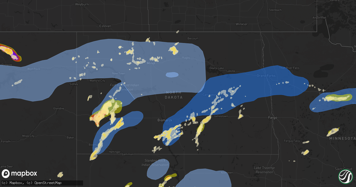
Hail Map in North Dakota on July 26, 2025
Get this storm
July 26 map
$229
one time, instant access
Download today. No call, no setup
Keep the $229
Bought the map and want the full workflow? Apply the entire $229 to a subscription within 7 days. None of it is wasted.
Every map, not just this one
This buys you this map. Subscription and you get every map we run, in the markets you choose from a few cities to whole states to nationwide. Plus real-time alerts the moment a storm fires.
Contact data
Name, contact info, occupancy, even credit band for addresses in the footprint. You go from where it hit to who to call.
Become the source they trust
Unlimited branding weather history reports on demand. You already have the documented answer ready for the property owner, and you are the one who showed up with it.
Property data and RoofTrace estimates
Pull up any address you have got, its value and the exact code rules for that jurisdiction, straight from One Click Code. Then RoofTrace estimates the squares, pitch, and roof value, priced the way you price.
Storm reports in North Dakota
North Dakota
| Date | Description |
|---|---|
| 07/26/20256:00 AM CDT | Nddot wind sensor. |
| 07/26/20255:53 AM CDT | Awos station k5h4 harvey nd awos. |
| 07/26/20255:35 AM CDT | A public report of 70 mph wind gusts and 2.1 inches of rain. |
| 07/26/20255:30 AM CDT | Nddot wind sensor. |
| 07/26/20255:28 AM CDT | Ndawn mesonet site. |
| 07/26/20255:22 AM CDT | Image shared via social media of damage to the roof of a metal shop 5 north of balfour. |
| 07/26/20255:18 AM CDT | Ndawn mesonet site 2 n karlsruhe. |
| 07/26/20255:15 AM CDT | A local report indicates 60 MPH wind near 2 SSW Minot |
| 07/26/20255:10 AM CDT | Social media reports of large grain bins being damaged and one completely knocked down in voltaire. |
| 07/26/20255:07 AM CDT | 10 m wind gust at ndawn station benedict 4 se. |
| 07/26/20255:05 AM CDT | Broadcast media shared photos a viewer sent in of wind damage in velva. The damage was caused by a metal out building blowing into a multi family home causing damage to |
| 07/26/20255:01 AM CDT | 10 m wind gust at ndawn station sawyer 7 s. |
| 07/26/20254:59 AM CDT | 10 m wind gust at ndawn station sawyer 7 s. |
| 07/26/20254:54 AM CDT | 10 m wind gust at ndawn station benedict 4 se. |
| 07/26/20254:50 AM CDT | Corrects previous tstm wnd dmg report from benedict. Facebook post showing a large tree snapped in half and large tree branches also snapped off. Estimated wind gusts 6 |
| 07/26/20254:50 AM CDT | 10 m wind gust at ndawn station benedict 4 se. |
| 07/26/20254:50 AM CDT | Facebook post showing a large tree snapped in half and large tree branches also snapped off. |
| 07/26/20254:49 AM CDT | Asos station kmot minot airport. |
| 07/26/20254:48 AM CDT | 10 m wind gust at ndawn station max 3 n. |
| 07/26/20254:38 AM CDT | Awos station k1dn 1 s max. |
| 07/26/20254:27 AM CDT | Asos station kn60 garrison. |
| 07/26/20254:06 AM CDT | 10 m wind gust at ndawn station pick city 8 sw. |
| 07/26/20254:00 AM CDT | Public social media report of a garage being blown apart with some down tree branches. |
| 07/26/20254:00 AM CDT | Mesonet station fw7163 raub. |
| 07/26/20253:53 AM CDT | 10 m wind gust at ndawn station zap 11 n. |
| 07/26/20253:53 AM CDT | Nddot wind sensor. Time estimated from radar. |
| 07/26/20253:44 AM CDT | 10 m wind gust at ndawn station zap 11 n. |
| 07/26/20253:35 AM CDT | Awos station kd57 glen ullin. |
| 07/26/20253:30 AM CDT | Social media report of a roof being ripped off a trailer home 4 miles east of twin buttes. |
| 07/26/20253:18 AM CDT | Wind gust measured by a personal weather station. Report relayed by emergency management. |
| 07/26/20253:16 AM CDT | 10 m wind gust at ndawn station hebron 7 s. |
| 07/26/20253:09 AM CDT | Facebook post. |
| 07/26/20253:09 AM CDT | 10 m wind gusts at ndawn station manning 4 sw. |
| 07/26/20253:00 AM CDT | Nddot wind sensor. |
| 07/26/20252:51 AM CDT | 10 m wind gust at ndawn station ray 4 n. |
| 07/26/20252:46 AM CDT | Wind gust measured by a personal weather station. Report relayed by emergency management. |
| 07/26/20252:46 AM CDT | Social media reports of damage to the roof of a business in belfield. |
| 07/26/20252:42 AM CDT | Facebook post showing metal roofing partially torn off a building. |
| 07/26/20252:20 AM CDT | Measured 10 meter wind gust at ndawn station new england 5w. |
| 07/26/20252:20 AM CDT | Twelve inch diamter tree down on roof of house. |
| 07/26/20252:20 AM CDT | Photo of large tree branches snapped via social media. Time estimated via radar. |
| 07/26/20252:19 AM CDT | A local report indicates 62 MPH wind near 2 SE Thompson |
| 07/26/20252:16 AM CDT | Asos station kgfk grand forks ap nd. |
| 07/26/20252:10 AM CDT | Wind gust recorded by ndawn station. |
| 07/26/20252:07 AM CDT | Ndawn station reporting 10 m winds. |
| 07/26/20251:59 AM CDT | Gf afb measured gust. |
| 07/26/20251:55 AM CDT | Mesonet station 321480 6 nnw charbonneau |
| 07/26/20251:49 AM CDT | Gust measured from private weather station. |
| 07/26/20251:33 AM CDT | Damage to several outbuildings. Lean to roof blown off. Several rafters of 40 by 60 outbuilding damaged in open doorway. Time estimated by radar. |
| 07/26/202512:38 AM CDT | 10 meter measured wind gust at ndawn station courtenay 5w. 53 mph gust at 3 meters. |
| 07/26/202512:16 AM CDT | Measured wind gust at private weather station. |
| 07/26/202512:04 AM CDT | Personal weather station 1 e of pettibone. |
| 07/25/202510:38 PM CDT | Pea sized hail and a few quarter size hail was reported from social media. |
All States Impacted by Hail Map on July 26, 2025
Cities Impacted by Hail Map on July 26, 2025
- Epping, ND
- Ray, ND
- White Earth, ND
- Tioga, ND
- Stanley, ND
- New Town, ND
- Ross, ND
- Watford City, ND
- Middletown, IL
- Elkhart, IL
- New Holland, IL
- Lincoln, IL
- Stanford, IL
- Atlanta, IL
- Delavan, IL
- Minier, IL
- Hartsburg, IL
- Emden, IL
- Armington, IL
- McLean, IL
- Bloomington, IL
- Danvers, IL
- Clinton, IL
- Beason, IL
- Shirley, IL
- Kenney, IL
- Mount Pulaski, IL
- Waynesville, IL
- Chestnut, IL
- Lawndale, IL
- Heyworth, IL
- Wapella, IL
- Lexington, IL
- Towanda, IL
- Normal, IL
- Hudson, IL
- Ellsworth, IL
- Downs, IL
- Le Roy, IL
- Cooksville, IL
- Clitherall, MN
- Vining, MN
- Battle Lake, MN
- Henning, MN
- Herman, MN
- Donnelly, MN
- Brandon, MN
- Evansville, MN
- Garfield, MN
- Alexandria, MN
- Shade Gap, PA
- Neelyton, PA
- Orbisonia, PA
- Three Springs, PA
- Berkeley Springs, WV
- Bowling Green, MO
- Willow Hill, PA
- Spring Run, PA
- Orrstown, PA
- Fannettsburg, PA
- Upperstrasburg, PA
- Pleasant Hall, PA
- Louisiana, MO
- Burnt Cabins, PA
- Knox, IN
- North Judson, IN
- Monterey, IN
- Ora, IN
- Hedgesville, WV
- Rensselaer, IN
- Harrisonville, MO
- Peculiar, MO
- Bennington, OK
- Martinsburg, WV
- Gerrardstown, WV
- Inwood, WV
- Walker, WV
- Elizabeth, WV
- Rochester, IN
- Kewanna, IN
- Lockney, TX
- Bunker Hill, WV
- Kearneysville, WV
- Fort Wayne, IN
- Summit Point, WV
- Maple Hill, NC
- Charles Town, WV
- South Vienna, OH
- South Charleston, OH
- Coldwater, OH
- Matador, TX
- Montezuma, OH
- Celina, OH
- Vega, TX
- Huntington, IN
- Columbia City, IN
- Sperryville, VA
- Silas, AL
- Saint Henry, OH
- Roanoke, IN
- Woodville, VA
- Childress, TX
- Lyman, NE
- Grand Marais, MN
- Paola, KS
- Saint Francis, SD
- Walsh, CO
- Silverton, TX
- Floydada, TX
- Converse, IN
- Marion, IN
- Faunsdale, AL
- Port Hope, MI
- Hay Springs, NE
- Clarence, MO
- Kinde, MI
- Hereford, TX
- Linden, AL
- Rushville, NE
- Mcadoo, TX
- Campo, CO
- Hemingford, NE
- Martinsville, IN
- Monrovia, IN
- Quincy, IN
- Stilesville, IN
- Clayton, IN
- Mooresville, IN
- Corn, OK
- Divernon, IL
- Glenarm, IL
- Auburn, IL
- Urbana, OH
- Two Dot, MT
- Carter, MT
- Brady, MT
- Mount Solon, VA
- Butler, PA
- Valencia, PA
- Gravois Mills, MO
- Millry, AL
- Mount Sidney, VA
- Staunton, VA
- Bridgeport, NE
- Bayard, NE
- Eutaw, AL
- Cloverdale, IN
- Mars, PA
- Angora, NE
- Verona, VA
- Weatherford, OK
- Stover, MO
- Edwards, MO
- Versailles, MO
- Fort Pierre, SD
- Hayes, SD
- Eagle Butte, SD
- Richfield, KS
- Hobson, MT
- Geyser, MT
- Ryegate, MT
- Haxtun, CO
- Owingsville, KY
- Gordon, NE
- Merriman, NE
- Saco, MT
- Hinsdale, MT
- Nelson, MO
- Colony, OK
- Alliance, NE
- Martin, SD
- Rolla, KS
- Shawmut, MT
- Fort Defiance, VA
- Crowell, TX
- Lavina, MT
- Santo, TX
- West Jefferson, OH
- Palo Pinto, TX
- Murphy, ID
- London, OH
- Waynesboro, VA
- Paducah, TX
- Palmyra, PA
- Norris, SD
- Lewistown, MT
- Buffalo, MT
- New Philadelphia, OH
- Ovid, CO
- Glasgow, MT
- Crozet, VA
- Lithopolis, OH
- Canal Winchester, OH
- Groveport, OH
- Roundup, MT
- Columbus, OH
- Lockbourne, OH
- Timber Lake, SD
- Trail City, SD
- Marsing, ID
- Homedale, ID
- Tuthill, SD
- Larslan, MT
- Long Valley, SD
- Hays, MT
- Dodson, MT
- Malta, MT
- Nashua, MT
- Fleming, CO
- Midland, SD
- Quanah, TX
- Turner, MT
- Hogeland, MT
- Hulett, WY
- Broadwater, NE
- Marshall, MO
- El Dorado Springs, MO
- Moore, MT
- Annville, PA
- Lebanon, PA
- Manheim, PA
- Elizabethtown, PA
- White River, SD
- Wood, SD
- Elkhart, KS
- Hilger, MT
- Gettysburg, SD
- Agar, SD
- Selby, SD
- Lebanon, SD
- Hoven, SD
- Bowdle, SD
- Java, SD
- Tolstoy, SD
- Onaka, SD
- Roscoe, SD
- Loring, MT
- Winifred, MT
- Chinook, MT
- Nyssa, OR
- Roy, MT
- Ridgeville, IN
- Ellsworth, NE
- Cascade, MT
- Lloyd, MT
- Ontario, OR
- Sedgwick, CO
- Onida, SD
- Farwell, MN
- Starbuck, MN
- Winnett, MT
- Brusett, MT
- Mosby, MT
- Vale, OR
- Whitewater, MT
- Zortman, MT
- Jordan, MT
- Fort Peck, MT
- Draper, SD
- Okaton, SD
- Murdo, SD
- Kadoka, SD
- Belvidere, SD
- Fort Yates, ND
- Harlem, MT
- Oshkosh, NE
- Selfridge, ND
- Mullen, NE
- Greencastle, PA
- Midland, TX
- Gardendale, TX
- Odessa, TX
- Goldsmith, TX
- Highmore, SD
- Seneca, SD
- Holabird, SD
- Solen, ND
- Wishek, ND
- Linton, ND
- Stanton, TX
- Ashley, ND
- Waynesboro, PA
- Cannon Ball, ND
- Sand Springs, MT
- Orient, SD
- Hyannis, NE
- Springfield, OH
- Farmersville, IL
- Ree Heights, SD
- Lehr, ND
- Hazelton, ND
- Mandan, ND
- Sabillasville, MD
- Cascade, MD
- Smithsburg, MD
- Hagerstown, MD
- Napoleon, ND
- Cohagen, MT
- Tulare, SD
- Redfield, SD
- Faulkton, SD
- Miller, SD
- Rockham, SD
- Saint Lawrence, SD
- Wessington, SD
- Harrold, SD
- Blunt, SD
- Pierre, SD
- Northville, SD
- Cresbard, SD
- Mansfield, SD
- Ipswich, SD
- Ashton, SD
- Hosmer, SD
- Whitman, NE
- Elsberry, MO
- Silex, MO
- Hammond, MT
- Boyes, MT
- Sturgis, SD
- Moffit, ND
- Braddock, ND
- Howes, SD
- Piedmont, SD
- Enning, SD
- New Underwood, SD
- Tappen, ND
- Streeter, ND
- Gackle, ND
- Saint Anthony, ND
- Menoken, ND
- Bismarck, ND
- Driscoll, ND
- Sterling, ND
- Union Center, SD
- Faith, SD
- Julesburg, CO
- Steele, ND
- Circle, MT
- Brockway, MT
- Frazer, MT
- Wolf Point, MT
- White Owl, SD
- Aberdeen, SD
- Mellette, SD
- Warner, SD
- Stratford, SD
- Turton, SD
- Brentford, SD
- Hitchcock, SD
- Medina, ND
- Dawson, ND
- Wing, ND
- Tuttle, ND
- Robinson, ND
- Newell, SD
- Vale, SD
- Cleveland, ND
- Woodworth, ND
- Buchanan, ND
- Venango, NE
- Pingree, ND
- Dupree, SD
- Meadow, SD
- Richey, MT
- Poplar, MT
- Vida, MT
- Bloomfield, MT
- Lambert, MT
- Lindsay, MT
- Bowdon, ND
- Wimbledon, ND
- Spiritwood, ND
- Courtenay, ND
- Pettibone, ND
- Jamestown, ND
- Kensal, ND
- Carrington, ND
- Sykeston, ND
- Valley City, ND
- Shields, ND
- Flasher, ND
- Seneca, NE
- Thedford, NE
- Anselmo, NE
- Oriska, ND
- Rogers, ND
- Dazey, ND
- Stapleton, NE
- Brockton, MT
- Sidney, MT
- Fairview, MT
- Froid, MT
- Culbertson, MT
- Bainville, MT
- Cathay, ND
- New Rockford, ND
- Sheyenne, ND
- Glenfield, ND
- Cooperstown, ND
- Mchenry, ND
- Grace City, ND
- Binford, ND
- Sutton, ND
- Hannaford, ND
- Luverne, ND
- Halsey, NE
- Merna, NE
- Arnold, NE
- Ludlow, SD
- Willow City, ND
- Towner, ND
- Bantry, ND
- Jessie, ND
- Aneta, ND
- Crary, ND
- Warwick, ND
- Mcville, ND
- Michigan, ND
- Lakota, ND
- Tolna, ND
- Oberon, ND
- Saint Michael, ND
- Pekin, ND
- Northwood, ND
- Finley, ND
- Petersburg, ND
- Clifford, ND
- Galesburg, ND
- Portland, ND
- Blanchard, ND
- Hope, ND
- Sharon, ND
- Hatton, ND
- Homestead, MT
- Medicine Lake, MT
- Dagmar, MT
- Williston, ND
- Cartwright, ND
- Bowman, ND
- Annada, MO
- Winchester, IN
- Scranton, ND
- Broken Bow, NE
- Bottineau, ND
- Fairfield, ND
- Amidon, ND
- New England, ND
- Donnybrook, ND
- Powers Lake, ND
- Kenmare, ND
- Alexander, ND
- Grassy Butte, ND
- Medora, ND
- Grenora, ND
- Belfield, ND
- Mohall, ND
- Lefor, ND
- Gladstone, ND
- Dickinson, ND
- Regent, ND
- Crookston, MN
- Richardton, ND
- Taylor, ND
- Maxbass, ND
- Manning, ND
- South Heart, ND
- Eolia, MO
- Mott, ND
- Zahl, ND
- Alamo, ND
- Ambrose, ND
- Trenton, ND
- Crosby, ND
- Mandaree, ND
- Arnegard, ND
- Keene, ND
- Wildrose, ND
- Killdeer, ND
- Sargent, NE
- Red Lake Falls, MN
- Mentor, MN
- Dunn Center, ND
- Halliday, ND
- Hettinger, ND
- Reeder, ND
- Hebron, ND
- Glen Ullin, ND
- New Leipzig, ND
- Niagara, ND
- Larimore, ND
- Emerado, ND
- Mayville, ND
- Arvilla, ND
- Gilby, ND
- Mekinock, ND
- Thompson, ND
- Grand Forks Afb, ND
- Manvel, ND
- Reynolds, ND
- East Grand Forks, MN
- Oslo, MN
- Grand Forks, ND
- Buxton, ND
- Warren, MN
- Fisher, MN
- Euclid, MN
- Nielsville, MN
- Beltrami, MN
- Shelly, MN
- Cummings, ND
- Caledonia, ND
- Climax, MN
- Ada, MN
- Hillsboro, ND
- Fertile, MN
- Thief River Falls, MN
- Saint Hilaire, MN
- Plummer, MN
- Brooks, MN
- Mcintosh, MN
- Fosston, MN
- Bejou, MN
- Winger, MN
- Gary, MN
- Erskine, MN
- Oklee, MN
- McIntosh, SD
- Isabel, SD
- McLaughlin, SD
- Little Eagle, SD
- Glencross, SD
- Wakpala, SD
- Vivian, SD
- Presho, SD
- Philip, SD
- Milesville, SD
- Cherry Creek, SD
- Trail, MN
- Clearbrook, MN
- Gully, MN
- Gonvick, MN
- Mahnomen, MN
- Bagley, MN
- Lengby, MN
- Palermo, ND
- Beulah, ND
- New Salem, ND
- Almont, ND
- Zap, ND
- Roseglen, ND
- Dodge, ND
- Golden Valley, ND
- Columbus, ND
- Noonan, ND
- Mcgregor, ND
- Lignite, ND
- Bowbells, ND
- Parshall, ND
- Berthold, ND
- Plaza, ND
- Garrison, ND
- Ryder, ND
- Hazen, ND
- Ogema, MN
- Leonard, MN
- Des Lacs, ND
- Burlington, ND
- Makoti, ND
- Surrey, ND
- Shevlin, MN
- Minot, ND
- Norwich, ND
- Laporte, MN
- Solway, MN
- Park Rapids, MN
- Granville, ND
- Deering, ND
- Glenburn, ND
- Bemidji, MN
- Lake George, MN
- Cass Lake, MN
- Ponsford, MN
- Akeley, MN
- Longville, MN
- Nevis, MN
- Walker, MN
- Pennington, MN
- Bena, MN
- Deer River, MN
- Minot Afb, ND
- Carpio, ND
- Douglas, ND
- Tolley, ND
- Lansford, ND
- Mercer, ND
- Benedict, ND
- Wolford, ND
- Westhope, ND
- Rugby, ND
- Turtle Lake, ND
- Martin, ND
- Underwood, ND
- Butte, ND
- Goodrich, ND
- York, ND
- Denhoff, ND
- Balta, ND
- Rolette, ND
- Velva, ND
- Coleharbor, ND
- Souris, ND
- Stanton, ND
- Newburg, ND
- Knox, ND
- Anamoose, ND
- Upham, ND
- Ruso, ND
- Fessenden, ND
- Mcclusky, ND
- Voltaire, ND
- Kramer, ND
- Riverdale, ND
- Balfour, ND
- Sawyer, ND
- Esmond, ND
- Max, ND
- Karlsruhe, ND
- Maddock, ND
- Harvey, ND
- Hurdsfield, ND
- Chaseley, ND
- Drake, ND
- Blackduck, MN
- Federal Dam, MN
- Max, MN
- Talmoon, MN
- Remer, MN
- Cohasset, MN
- Grand Rapids, MN
- Marcell, MN
- Bigfork, MN
- Minnewaukan, ND
- Cando, ND
- Mylo, ND
- Bisbee, ND
- Agate, ND
- Leeds, ND
- Motley, MN
- Staples, MN
- Nashwauk, MN
- Goodland, MN
- Calumet, MN
- Coleraine, MN
- Hibbing, MN
- Pengilly, MN
- Bovey, MN
- Marble, MN
- Taconite, MN
- Keewatin, MN
- Cook, MN
- Side Lake, MN
- Chisholm, MN
- Pequot Lakes, MN
- Nisswa, MN
- Pine River, MN


