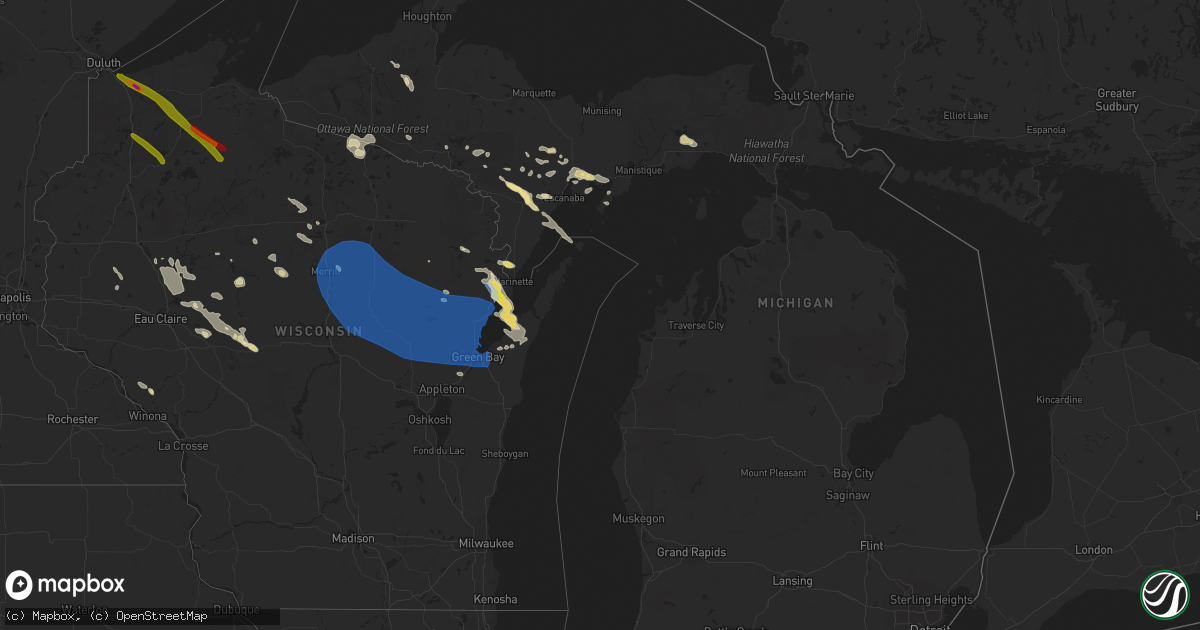
Hail Map in Michigan on July 26, 2021
Get this storm
July 26 map
$229
one time, instant access
Download today. No call, no setup
Keep the $229
Bought the map and want the full workflow? Apply the entire $229 to a subscription within 7 days. None of it is wasted.
Every map, not just this one
This buys you this map. Subscription and you get every map we run, in the markets you choose from a few cities to whole states to nationwide. Plus real-time alerts the moment a storm fires.
Contact data
Name, contact info, occupancy, even credit band for addresses in the footprint. You go from where it hit to who to call.
Become the source they trust
Unlimited branding weather history reports on demand. You already have the documented answer ready for the property owner, and you are the one who showed up with it.
Property data and RoofTrace estimates
Pull up any address you have got, its value and the exact code rules for that jurisdiction, straight from One Click Code. Then RoofTrace estimates the squares, pitch, and roof value, priced the way you price.
Storm reports in Michigan
Michigan
| Date | Description |
|---|---|
| 07/26/20216:33 AM CDT | At 1132 PM CDT, severe thunderstorms were located along a line extending from 9 miles north of Carter to 8 miles southwest of Antigo to near Rib Mountain, moving east at 55 mph. HAZARD...60 mph wind gusts and penny size hail. SOURCE...Law enforcement. IMPACT...Expect damage to roofs, siding, and trees. Locations impacted include... Neopit, Wittenberg, Keshena, Shawano, Wausaukee, Legend Lake, Gillett and Pulaski. |
| 07/26/20215:42 AM CDT | At 1042 PM EDT/942 PM CDT/, a severe thunderstorm was located 7 miles north of Sidnaw, or 17 miles southwest of Baraga, moving southeast at 30 mph. HAZARD...60 mph wind gusts and quarter size hail. SOURCE...Radar indicated. IMPACT...Hail damage to vehicles is expected. Expect wind damage to roofs, siding, and trees. This severe thunderstorm will be near... Sidnaw around 1055 PM EDT. Covington around 1100 PM EDT.Other locations in the path of this severe thunderstorm include U.S.141 between Covington and Amasa. |
| 07/26/20215:30 AM CDT | At 1030 PM CDT, a severe thunderstorm was located 7 miles west of Phelps, or 10 miles north of Eagle River, moving east at 25 mph. HAZARD...60 mph wind gusts and quarter size hail. SOURCE...Radar indicated. IMPACT...Hail damage to vehicles is expected. Expect wind damage to roofs, siding, and trees. This severe thunderstorm will be near... Phelps around 1050 PM CDT.Other locations in the path of this severe thunderstorm includeKentuck Lake Campground. |
| 07/26/20215:12 AM CDT | At 1011 PM EDT/911 PM CDT/, a severe thunderstorm was located 12 miles north of Bessemer, or 16 miles northeast of Ironwood, moving southeast at 60 mph. HAZARD...60 mph wind gusts and quarter size hail. SOURCE...Radar indicated. IMPACT...Hail damage to vehicles is expected. Expect wind damage to roofs, siding, and trees. This severe thunderstorm will be near... Porcupine Mountains State Park around ${dateUtil.format(${pc.time}, ${timeFormat.clock}, ${pc.timeZone})}.Other locations in the path of this severe thunderstorm includeMarenisco. |
| 07/26/20213:42 AM CDT | At 842 PM EDT/742 PM CDT/, a severe thunderstorm was located near Powers, or 17 miles west of Escanaba, moving southeast at 25 mph. HAZARD...Quarter size hail. SOURCE...Radar indicated. IMPACT...Damage to vehicles is expected. This severe thunderstorm will remain over mainly rural areas of southwestern Delta and northeastern Menominee Counties, including the following locations... Wilson, Gourley, Bark River and Spalding. |
| 07/26/20212:12 AM CDT | At 712 PM CDT, a severe thunderstorm was located 9 miles west of La Branche, or 19 miles east of Iron Mountain, moving southeast at 20 mph. HAZARD...Quarter size hail. SOURCE...Radar indicated. IMPACT...Damage to vehicles is expected. Locations impacted include... Hermansville and Powers. |
| 07/26/202112:38 AM CDT | Pictures from facebook show multiple trees down in the escanaba area. Time estimated via radar. |
| 07/25/202111:30 PM CDT | Corrects previous tstm wnd dmg report from 5 ssw randville. Reported significant winds and power outages. Have pictures online of grasses and plants blown in a single d |
| 07/25/202111:19 PM CDT | Public report of power lines down and large trees uprooted at peavey falls. Time estimated by radar. |
| 07/25/202111:08 PM CDT | At 407 PM CDT, a severe thunderstorm was located 9 miles southwest of Marinette, moving southeast at 20 mph. HAZARD...70 mph wind gusts and quarter size hail. SOURCE...Radar indicated. IMPACT...Hail damage to vehicles is expected. Expect considerable tree damage. Wind damage is also likely to mobile homes, roofs, and outbuildings. Locations impacted include... Marinette, Oconto, Peshtigo, Porterfield, Lena, Harmony, Cullen and County Line. |
| 07/25/202110:45 PM CDT | At 345 PM CDT, a severe thunderstorm was located 9 miles east of Crivitz, or 11 miles northwest of Menominee, moving east at 25 mph. HAZARD...60 mph wind gusts and quarter size hail. SOURCE...Radar indicated. IMPACT...Hail damage to vehicles is expected. Expect wind damage to roofs, siding, and trees. Locations impacted include... Marinette, Menominee, Crivitz, Pound, Peshtigo, Porterfield, Beaver, Middle Inlet, Coleman and Harmony. |
| 07/25/20219:50 PM CDT | Multiple reports of trees down... Several road closures... And numerous power outages near marenisco. Time estimated with radar. |
| 07/25/20219:50 PM CDT | Marenisco township fire department reported significant roof damage at a newly built garage structure at the corner of hall and mill streets in marenisco. Over a quarte |
| 07/25/20219:50 PM CDT | U.s. National forest service rangers reported downed and uprooted trees at the access road into the ottawa national forest bobcat lake campground located to the southea |
| 07/25/20219:50 PM CDT | U.s. National forest service rangers from the ottawa national forest reported downed and uprooted trees along u.s. Forest service road 8190 or dunham road located west |
| 07/25/20219:45 PM CDT | U.s. National forest service rangers from the ottawa national forest reported significant tree damage along forest service road 9300 and wolf mountain road in the ottaw |
| 07/25/20219:45 PM CDT | U.s. National forest service rangers from the ottawa national forest reported significant tree damage along the great lakes road approx. 5 miles northwest of marenisco |
| 07/25/20219:30 PM CDT | Ironwood public safety department reports extensive storm damage throughout gogebic county with numerous trees and power lines down. Time estimated by radar. |
All States Impacted by Hail Map on July 26, 2021
Cities Impacted by Hail Map on July 26, 2021
- Mechanicsville, VA
- Merrill, WI
- Sagola, MI
- Wallace, MI
- Porterfield, WI
- Menominee, MI
- Glade Hill, VA
- Rocky Mount, VA
- Hopewell, VA
- Whitley City, KY
- Parkers Lake, KY
- Dumas, TX
- Dimmitt, TX
- Spalding, MI
- Wilson, MI
- Hermansville, MI
- Perronville, MI
- Powers, MI
- Redby, MN
- Garden, MI
- Thorp, WI
- Stanley, WI
- Vesuvius, VA
- Amherst, VA
- Disputanta, VA
- Prince George, VA
- Rapid River, MI
- Chesterfield, VA
- Amelia Court House, VA
- Columbus, MS
- Bard, NM
- Hiwassee, VA
- Pulaski, VA
- Arcadia, WI
- Fountain City, WI
- La Plata, MD
- Indian Head, MD
- Welcome, MD
- Boyceville, WI
- Pep, NM
- Wichita, KS
- Haysville, KS
- Wetumka, OK
- Muleshoe, TX
- Clinton, MD
- Mcpherson, KS
- Windom, KS
- Withee, WI
- Lublin, WI
- Brussels, WI
- Luxemburg, WI
- New Franken, WI
- Burrton, KS
- Raphine, VA
- Foster City, MI
- Willard, WI
- Roseland, VA
- Neillsville, WI
- Rock, MI
- Beltrami, MN
- Crookston, MN
- Fort Washington, MD
- Temple Hills, MD
- Sudan, TX
- Rutland, VT
- Sandston, VA
- Naubinway, MI
- Engadine, MI
- Gould City, MI
- Curtis, MI
- Germfask, MI
- Washington, DC
- Takoma Park, MD
- Vulcan, MI
- Athelstane, WI
- Crivitz, WI
- Montebello, VA
- Tyro, VA
- Geuda Springs, KS
- Crystal Falls, MI
- Prairie Farm, WI
- Ridgeland, WI
- Wheeler, WI
- Land O'Lakes, WI
- Mahnomen, MN
- Mcintosh, MN
- Fosston, MN
- Mason, TN
- Nellysford, VA
- Portales, NM
- Oxon Hill, MD
- Greenbrier, TN
- Rib Lake, WI
- Westboro, WI
- Medford, WI
- Fairchild, WI
- Nardin, OK
- Colton, NY
- Peshtigo, WI
- Sturgeon Bay, WI
- Oconto, WI
- Forestville, WI
- Marinette, WI
- Conover, WI
- Tripoli, WI
- Augusta, WI
- Staunton, VA
- Fishersville, VA
- Waynesboro, VA
- Drumright, OK
- Jennings, OK
- Greenwood, WI
- Tomahawk, WI
- South Haven, KS
- Lyons, KS
- Little River, KS
- Amite, LA
- Trout Creek, MI
- Pelkie, MI
- Perkins, MI
- Hennessey, OK
- San Jon, NM
- Glenham, SD
- Chevy Chase, MD
- Kensington, MD
- Hyattsville, MD
- Silver Spring, MD
- Kim, CO
- Owings, MD
- Warfordsburg, PA
- Artemas, PA
- Little Orleans, MD
- Hancock, MD
- Faber, VA
- Duff, TN
- Gladys, VA
- Stony Creek, VA
- Sedley, VA
- Yale, VA
- Waverly, VA
- Wakefield, VA
- Bark River, MI
- Escanaba, MI
- Canton, NY
- Sterling, KS
- Guthrie, OK
- Casco, WI
- Little Lake, MI
- Shelbyville, TN
- Kaukauna, WI
- De Pere, WI
- Pioche, NV
- Benton, KS
- Towanda, KS
- Andover, KS
- Augusta, KS
- Rogers, NM
- Selby, SD
- Mobridge, SD
- Jamestown, KY
- Crescent, OK
- New Auburn, WI
- Mountain, WI
- Stuarts Draft, VA
- Dublin, VA
- Covington, OK
- Garber, OK
- Erath, LA
- Cadott, WI
- Arab, AL
- Providence Forge, VA
- Norwood, NY
- Potsdam, NY
- Milnesand, NM
- Afton, VA
- Lyndhurst, VA
- Suring, WI
- Granton, WI
- Inman, KS
- Franklin, TN
- Salina, KS
- Lindsborg, KS
- Braman, OK
- Meeker, OK
- Corinth, MS
- Nahma, MI
- Edmond, OK
- Cornell, MI
- Fluker, LA
- Roseland, LA
- Grenville, NM
- Michie, TN
- Chippewa Falls, WI
- Boyd, WI
- Purvis, MS
- Hattiesburg, MS
- Angie, LA
- Franklinton, LA
- Albany, KY
- Naytahwaush, MN
- Redlake, MN
- Puposky, MN
- Algoma, WI
- Pound, WI
- Friendship, MD
- Sunderland, MD
- Chesapeake Beach, MD
- Tracys Landing, MD
- North Beach, MD
- Okmulgee, OK
- Reliance, TN
- Tellico Plains, TN
- Hominy, OK
- Mass City, MI
- Ontonagon, MI
- Winfield, KS
- Penhook, VA
- Weleetka, OK
- Spring Grove, VA
- Courtland, VA
- Franklin, VA
- Newsoms, VA
- Capron, VA
- Dawson, ND
- Stephenson, MI
- Galva, KS
- Alma, WI
- Cochrane, WI
- Owen, WI
- Ogema, WI
- Catawba, WI
- Pleasant View, TN
- Springfield, TN
- Joelton, TN
- Iron Mountain, MI
- Monroe, VA
- Rockbridge Baths, VA
- Radford, VA
- Morgan City, LA
- Bogalusa, LA
- Ponemah, MN
- Blackduck, MN
- Gillett, WI
- Lawrenceville, GA
- Crossroads, NM
- Tatum, NM
- Andover, SD
- Roswell, NM
- Kentwood, LA
- Buckingham, VA
- Appomattox, VA
- Dillwyn, VA
- Hodgen, OK
- Clayton, NM
- Henrico, VA
- Henryetta, OK
- Somerset, KY
- Texico, NM
- Dustin, OK
- Cornell, WI
- Holcombe, WI
- Bloomer, WI
- Jim Falls, WI
- Deer Creek, OK
- Sedan, NM
- Chester, VA
- Colonial Heights, VA
- Petersburg, VA
- Iron River, MI
- Fairmont, OK
- Pawnee, OK
- Falun, KS
- Cleveland, OK
- Lovingston, VA
- Clearwater, KS
- Broadview, NM
- Sheldon, WI
- Murfreesboro, AR
- Manchester, TN
- Campo, CO
- Arkansas City, KS
- Gilman, WI
- Churchville, VA
- Swoope, VA
- Mcminnville, TN
- Gladstone, MI
- Charles City, VA
- Bells, TN
- Crossville, TN
- Saint George, UT
- Dalton, GA
- Blackwell, OK
- Piedmont, OK
- Eagle Rock, VA
- Fincastle, VA
- Gary, MN
- Causey, NM
- Alexandria, VA
- Arlington, VA
- Watersmeet, MI
- Bowman, GA
- Richmond, VA
- Wellston, OK
- Burtonsville, MD
- Spencerville, MD
- Mcconnell Afb, KS
- Derby, KS
- Bison, OK
- Hayward, WI
- Clam Lake, WI
- Cable, WI
- Butternut, WI
- Maple, WI
- Lake Nebagamon, WI
- Glidden, WI
- Superior, WI
- Mellen, WI
- Brule, WI
- Solon Springs, WI
- Iron River, WI
- Drummond, WI
- Poplar, WI
- South Range, WI
- Minong, WI
- Gordon, WI
- Tappen, ND
- Deer River, MN
- Hines, MN
- Cass Lake, MN
- Bena, MN
- Bemidji, MN
- Tenstrike, MN
- Pennington, MN
- Marcell, MN
- Bigfork, MN
- Spring Lake, MN
- Talmoon, MN
- Grand Rapids, MN
- Bovey, MN
- Hibbing, MN
- Coleman, WI
- Birnamwood, WI
- Cecil, WI
- Embarrass, WI
- Bear Creek, WI
- Clintonville, WI
- Gresham, WI
- Mattoon, WI
- Little Suamico, WI
- Shawano, WI
- Oconto Falls, WI
- Wittenberg, WI
- Tigerton, WI
- Oneida, WI
- Marion, WI
- Antigo, WI
- Hatley, WI
- Rothschild, WI
- Suamico, WI
- Deerbrook, WI
- Bowler, WI
- Bonduel, WI
- Summit Lake, WI
- Elton, WI
- Lena, WI
- Iola, WI
- Brokaw, WI
- Aniwa, WI
- Krakow, WI
- White Lake, WI
- Schofield, WI
- Neopit, WI
- Nichols, WI
- Ogdensburg, WI
- Irma, WI
- Eland, WI
- Rosholt, WI
- Ringle, WI
- Pulaski, WI
- Leopolis, WI
- Sobieski, WI
- Wausau, WI
- Shiocton, WI
- New London, WI
- Tilleda, WI
- Green Valley, WI
- Manawa, WI
- Bryant, WI
- Caroline, WI
- Athens, WI
- Seymour, WI
- Abrams, WI
- Mosinee, WI
- Keshena, WI
- Green Bay, WI
- Black Creek, WI
- Gleason, WI
- Washington, UT


