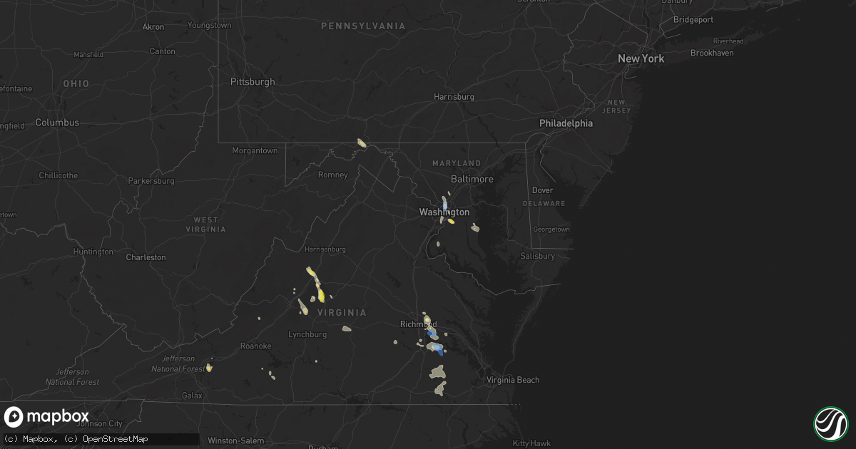
Hail Map in Maryland on July 26, 2021
Get this storm
July 26 map
$229
one time, instant access
Download today. No call, no setup
Keep the $229
Bought the map and want the full workflow? Apply the entire $229 to a subscription within 7 days. None of it is wasted.
Every map, not just this one
This buys you this map. Subscription and you get every map we run, in the markets you choose from a few cities to whole states to nationwide. Plus real-time alerts the moment a storm fires.
Contact data
Name, contact info, occupancy, even credit band for addresses in the footprint. You go from where it hit to who to call.
Become the source they trust
Unlimited branding weather history reports on demand. You already have the documented answer ready for the property owner, and you are the one who showed up with it.
Property data and RoofTrace estimates
Pull up any address you have got, its value and the exact code rules for that jurisdiction, straight from One Click Code. Then RoofTrace estimates the squares, pitch, and roof value, priced the way you price.
Storm reports in Maryland
Maryland
| Date | Description |
|---|---|
| 07/26/20216:16 PM CDT | Tree and wires down near the intersection of university blvd west and reedie drive |
| 07/26/20216:10 PM CDT | Numerous trees and powerlines down across the city of takoma park |
| 07/26/20216:10 PM CDT | Tree down on house and powerlines down on the 8100 block of flower avenue |
| 07/26/20216:08 PM CDT | Tree down on house and wires down on road in the 7400 block of piney branch road. |
| 07/26/20216:04 PM CDT | Tree down on house in the 7900 block of piney branch road. |
| 07/26/20216:01 PM CDT | Numerous trees and powerlines down within the city of silver spring |
| 07/26/20215:57 PM CDT | Tree down on house in the 8100 block of flower ave. Wires also down. |
| 07/26/20215:53 PM CDT | Numerous wires and trees down on sligo creek parkway. |
| 07/26/20215:52 PM CDT | Tree blew down onto a house in the 11700 block of fullham street. |
| 07/26/20215:49 PM CDT | Tree and wires down on scott drive near beaumont road. Telephone pole snapped. |
| 07/26/20215:49 PM CDT | Tree down on house on fulham street off of kersey road. |
| 07/26/20215:49 PM CDT | Tree down on house on fulham street off of kersey road. |
| 07/26/20215:48 PM CDT | Tree and wires down on university blvd west near reedie drive. |
| 07/26/20212:30 PM CDT | Tree and powerlines down near summer city blvd and 4th street |
| 07/26/20212:26 PM CDT | Multiple trees and powerlines down in north beach area. |
| 07/26/20214:07 AM CDT | At 906 PM EDT, severe thunderstorms were located along a line extending from 6 miles northeast of Potomac Creek to 7 miles west of Fredericksburg, moving southeast at 15 mph. HAZARD...60 mph wind gusts. SOURCE...Radar indicated. IMPACT...Damaging winds will cause some trees and large branches to fall. This could injure those outdoors, as well as damage homes and vehicles. Roadways may become blocked by downed trees. Localized power outages are possible. Unsecured light objects may become projectiles. Locations impacted include... Stafford, Fredericksburg, King George, Quantico, Fairview Beach, Potomac Creek, Aquia Creek, Triangle, Massaponax, Spotsylvania, Cherry Hill, Falmouth, Passapatanzy, Stones Corner, Roseville, Garrisonville, Ramoth, Thornburg, Dunavant and White Oak. |
| 07/26/20213:24 AM CDT | At 824 PM EDT, a severe thunderstorm was located over Camp Springs, or over Andrews Air Force Base, moving southeast at 20 mph. HAZARD...60 mph wind gusts and half dollar size hail. SOURCE...Radar indicated. IMPACT...Damaging winds will cause some trees and large branches to fall. This could injure those outdoors, as well as damage homes and vehicles. Roadways may become blocked by downed trees. Localized power outages are possible. Unsecured light objects may become projectiles. Locations impacted include... Clinton, Forestville, National Harbor, Upper Marlboro, Andrews Air Force Base, Camp Springs, Oxon Hill, Rosaryville, Friendly, Marlton, Temple Hills, Marlow Heights, Brandywine, District Heights, Forest Heights, Baden, Morningside, Suitland-Silver Hill and Cheltenham. |
| 07/26/20213:01 AM CDT | At 801 PM EDT, severe thunderstorms were located along a line extending from Lake Ridge to 8 miles south of Linton Hall, moving southeast at 25 mph. HAZARD...60 mph wind gusts. SOURCE...Radar indicated. IMPACT...Damaging winds will cause some trees and large branches to fall. This could injure those outdoors, as well as damage homes and vehicles. Roadways may become blocked by downed trees. Localized power outages are possible. Unsecured light objects may become projectiles. Locations impacted include... Dale City, La Plata, Woodbridge, Quantico, Lake Ridge, Linton Hall, Montclair, Lorton, Triangle, Dumfries, Manassas, Cherry Hill, Independent Hill, Bryans Road, Mason Neck, Nokesville, Potomac Heights, Occoquan, Pomfret and Catlett. |
| 07/26/20211:46 AM CDT | At 646 PM EDT, a severe thunderstorm was located over Wheaton-Glenmont, or near Langley Park, moving southeast at 10 mph. HAZARD...Ping pong ball size hail and 60 mph wind gusts. SOURCE...Radar indicated. IMPACT...Damaging winds will cause some trees and large branches to fall. This could injure those outdoors, as well as damage homes and vehicles. Roadways may become blocked by downed trees. Localized power outages are possible. Unsecured light objects may become projectiles. Locations impacted include... Columbia, Rockville, Bethesda, Bowie, Severn, Olney, College Park, Greenbelt, Langley Park, Beltsville, Coral Hills, Bladensburg, University of Maryland, Fedex Field, Fort Totten, Aspen Hill, North Bethesda, Odenton, Laurel and Fairland. |
| 07/25/202110:21 PM CDT | At 321 PM EDT, a severe thunderstorm was located over Deale, moving southeast at 5 mph. HAZARD...Golf ball size hail and 70 mph wind gusts. SOURCE...Radar indicated. IMPACT...Expect wind damage to trees and power lines. Hail is large enough to dent and damage vehicles. Some hail damage to roofs, siding, and windows is possible. Locations impacted include... Shady Side, Chesapeake Beach, Deale, Dunkirk, Owings, Friendship, Mount Harmony and Tracys Landing. |
| 07/25/20218:08 PM CDT | Ten trees down in the nanjemoy area. |
| 07/25/20218:05 PM CDT | At 105 AM EDT, a severe thunderstorm was located over Massey, or 11 miles southwest of Middletown, moving southeast at 15 mph. HAZARD...60 mph wind gusts. SOURCE...Radar indicated. IMPACT...Damage to roofs, siding, trees, and power lines is possible. Locations impacted include... Clayton, Millington, Sudlersville, Hartly, Sassafras, Delaney Corner, Massey, Galena and Kenton. |
| 07/25/20217:48 PM CDT | Multiple trees down in the marbury area. |
| 07/25/20217:33 PM CDT | A local report indicates 1.25 inch wind near 1 SW ANDREWS AFB |
| 07/25/20217:27 PM CDT | Tree and wires down on chicamuxen road near henry e. Lackey high school. |
| 07/25/20217:27 PM CDT | Tree and wires down on chicamuxen road near henry e. Lackey high school. |
| 07/25/20217:27 PM CDT | A couple trees down in the indian head area. |
All States Impacted by Hail Map on July 26, 2021
Cities Impacted by Hail Map on July 26, 2021
- Mechanicsville, VA
- Merrill, WI
- Sagola, MI
- Wallace, MI
- Porterfield, WI
- Menominee, MI
- Glade Hill, VA
- Rocky Mount, VA
- Hopewell, VA
- Whitley City, KY
- Parkers Lake, KY
- Dumas, TX
- Dimmitt, TX
- Spalding, MI
- Wilson, MI
- Hermansville, MI
- Perronville, MI
- Powers, MI
- Redby, MN
- Garden, MI
- Thorp, WI
- Stanley, WI
- Vesuvius, VA
- Amherst, VA
- Disputanta, VA
- Prince George, VA
- Rapid River, MI
- Chesterfield, VA
- Amelia Court House, VA
- Columbus, MS
- Bard, NM
- Hiwassee, VA
- Pulaski, VA
- Arcadia, WI
- Fountain City, WI
- La Plata, MD
- Indian Head, MD
- Welcome, MD
- Boyceville, WI
- Pep, NM
- Wichita, KS
- Haysville, KS
- Wetumka, OK
- Muleshoe, TX
- Clinton, MD
- Mcpherson, KS
- Windom, KS
- Withee, WI
- Lublin, WI
- Brussels, WI
- Luxemburg, WI
- New Franken, WI
- Burrton, KS
- Raphine, VA
- Foster City, MI
- Willard, WI
- Roseland, VA
- Neillsville, WI
- Rock, MI
- Beltrami, MN
- Crookston, MN
- Fort Washington, MD
- Temple Hills, MD
- Sudan, TX
- Rutland, VT
- Sandston, VA
- Naubinway, MI
- Engadine, MI
- Gould City, MI
- Curtis, MI
- Germfask, MI
- Washington, DC
- Takoma Park, MD
- Vulcan, MI
- Athelstane, WI
- Crivitz, WI
- Montebello, VA
- Tyro, VA
- Geuda Springs, KS
- Crystal Falls, MI
- Prairie Farm, WI
- Ridgeland, WI
- Wheeler, WI
- Land O'Lakes, WI
- Mahnomen, MN
- Mcintosh, MN
- Fosston, MN
- Mason, TN
- Nellysford, VA
- Portales, NM
- Oxon Hill, MD
- Greenbrier, TN
- Rib Lake, WI
- Westboro, WI
- Medford, WI
- Fairchild, WI
- Nardin, OK
- Colton, NY
- Peshtigo, WI
- Sturgeon Bay, WI
- Oconto, WI
- Forestville, WI
- Marinette, WI
- Conover, WI
- Tripoli, WI
- Augusta, WI
- Staunton, VA
- Fishersville, VA
- Waynesboro, VA
- Drumright, OK
- Jennings, OK
- Greenwood, WI
- Tomahawk, WI
- South Haven, KS
- Lyons, KS
- Little River, KS
- Amite, LA
- Trout Creek, MI
- Pelkie, MI
- Perkins, MI
- Hennessey, OK
- San Jon, NM
- Glenham, SD
- Chevy Chase, MD
- Kensington, MD
- Hyattsville, MD
- Silver Spring, MD
- Kim, CO
- Owings, MD
- Warfordsburg, PA
- Artemas, PA
- Little Orleans, MD
- Hancock, MD
- Faber, VA
- Duff, TN
- Gladys, VA
- Stony Creek, VA
- Sedley, VA
- Yale, VA
- Waverly, VA
- Wakefield, VA
- Bark River, MI
- Escanaba, MI
- Canton, NY
- Sterling, KS
- Guthrie, OK
- Casco, WI
- Little Lake, MI
- Shelbyville, TN
- Kaukauna, WI
- De Pere, WI
- Pioche, NV
- Benton, KS
- Towanda, KS
- Andover, KS
- Augusta, KS
- Rogers, NM
- Selby, SD
- Mobridge, SD
- Jamestown, KY
- Crescent, OK
- New Auburn, WI
- Mountain, WI
- Stuarts Draft, VA
- Dublin, VA
- Covington, OK
- Garber, OK
- Erath, LA
- Cadott, WI
- Arab, AL
- Providence Forge, VA
- Norwood, NY
- Potsdam, NY
- Milnesand, NM
- Afton, VA
- Lyndhurst, VA
- Suring, WI
- Granton, WI
- Inman, KS
- Franklin, TN
- Salina, KS
- Lindsborg, KS
- Braman, OK
- Meeker, OK
- Corinth, MS
- Nahma, MI
- Edmond, OK
- Cornell, MI
- Fluker, LA
- Roseland, LA
- Grenville, NM
- Michie, TN
- Chippewa Falls, WI
- Boyd, WI
- Purvis, MS
- Hattiesburg, MS
- Angie, LA
- Franklinton, LA
- Albany, KY
- Naytahwaush, MN
- Redlake, MN
- Puposky, MN
- Algoma, WI
- Pound, WI
- Friendship, MD
- Sunderland, MD
- Chesapeake Beach, MD
- Tracys Landing, MD
- North Beach, MD
- Okmulgee, OK
- Reliance, TN
- Tellico Plains, TN
- Hominy, OK
- Mass City, MI
- Ontonagon, MI
- Winfield, KS
- Penhook, VA
- Weleetka, OK
- Spring Grove, VA
- Courtland, VA
- Franklin, VA
- Newsoms, VA
- Capron, VA
- Dawson, ND
- Stephenson, MI
- Galva, KS
- Alma, WI
- Cochrane, WI
- Owen, WI
- Ogema, WI
- Catawba, WI
- Pleasant View, TN
- Springfield, TN
- Joelton, TN
- Iron Mountain, MI
- Monroe, VA
- Rockbridge Baths, VA
- Radford, VA
- Morgan City, LA
- Bogalusa, LA
- Ponemah, MN
- Blackduck, MN
- Gillett, WI
- Lawrenceville, GA
- Crossroads, NM
- Tatum, NM
- Andover, SD
- Roswell, NM
- Kentwood, LA
- Buckingham, VA
- Appomattox, VA
- Dillwyn, VA
- Hodgen, OK
- Clayton, NM
- Henrico, VA
- Henryetta, OK
- Somerset, KY
- Texico, NM
- Dustin, OK
- Cornell, WI
- Holcombe, WI
- Bloomer, WI
- Jim Falls, WI
- Deer Creek, OK
- Sedan, NM
- Chester, VA
- Colonial Heights, VA
- Petersburg, VA
- Iron River, MI
- Fairmont, OK
- Pawnee, OK
- Falun, KS
- Cleveland, OK
- Lovingston, VA
- Clearwater, KS
- Broadview, NM
- Sheldon, WI
- Murfreesboro, AR
- Manchester, TN
- Campo, CO
- Arkansas City, KS
- Gilman, WI
- Churchville, VA
- Swoope, VA
- Mcminnville, TN
- Gladstone, MI
- Charles City, VA
- Bells, TN
- Crossville, TN
- Saint George, UT
- Dalton, GA
- Blackwell, OK
- Piedmont, OK
- Eagle Rock, VA
- Fincastle, VA
- Gary, MN
- Causey, NM
- Alexandria, VA
- Arlington, VA
- Watersmeet, MI
- Bowman, GA
- Richmond, VA
- Wellston, OK
- Burtonsville, MD
- Spencerville, MD
- Mcconnell Afb, KS
- Derby, KS
- Bison, OK
- Hayward, WI
- Clam Lake, WI
- Cable, WI
- Butternut, WI
- Maple, WI
- Lake Nebagamon, WI
- Glidden, WI
- Superior, WI
- Mellen, WI
- Brule, WI
- Solon Springs, WI
- Iron River, WI
- Drummond, WI
- Poplar, WI
- South Range, WI
- Minong, WI
- Gordon, WI
- Tappen, ND
- Deer River, MN
- Hines, MN
- Cass Lake, MN
- Bena, MN
- Bemidji, MN
- Tenstrike, MN
- Pennington, MN
- Marcell, MN
- Bigfork, MN
- Spring Lake, MN
- Talmoon, MN
- Grand Rapids, MN
- Bovey, MN
- Hibbing, MN
- Coleman, WI
- Birnamwood, WI
- Cecil, WI
- Embarrass, WI
- Bear Creek, WI
- Clintonville, WI
- Gresham, WI
- Mattoon, WI
- Little Suamico, WI
- Shawano, WI
- Oconto Falls, WI
- Wittenberg, WI
- Tigerton, WI
- Oneida, WI
- Marion, WI
- Antigo, WI
- Hatley, WI
- Rothschild, WI
- Suamico, WI
- Deerbrook, WI
- Bowler, WI
- Bonduel, WI
- Summit Lake, WI
- Elton, WI
- Lena, WI
- Iola, WI
- Brokaw, WI
- Aniwa, WI
- Krakow, WI
- White Lake, WI
- Schofield, WI
- Neopit, WI
- Nichols, WI
- Ogdensburg, WI
- Irma, WI
- Eland, WI
- Rosholt, WI
- Ringle, WI
- Pulaski, WI
- Leopolis, WI
- Sobieski, WI
- Wausau, WI
- Shiocton, WI
- New London, WI
- Tilleda, WI
- Green Valley, WI
- Manawa, WI
- Bryant, WI
- Caroline, WI
- Athens, WI
- Seymour, WI
- Abrams, WI
- Mosinee, WI
- Keshena, WI
- Green Bay, WI
- Black Creek, WI
- Gleason, WI
- Washington, UT


