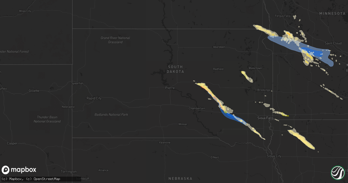
Hail Map in South Dakota on July 25, 2023
Get this storm
July 25 map
$229
one time, instant access
Download today. No call, no setup
Keep the $229
Bought the map and want the full workflow? Apply the entire $229 to a subscription within 7 days. None of it is wasted.
Every map, not just this one
This buys you this map. Subscription and you get every map we run, in the markets you choose from a few cities to whole states to nationwide. Plus real-time alerts the moment a storm fires.
Contact data
Name, contact info, occupancy, even credit band for addresses in the footprint. You go from where it hit to who to call.
Become the source they trust
Unlimited branding weather history reports on demand. You already have the documented answer ready for the property owner, and you are the one who showed up with it.
Property data and RoofTrace estimates
Pull up any address you have got, its value and the exact code rules for that jurisdiction, straight from One Click Code. Then RoofTrace estimates the squares, pitch, and roof value, priced the way you price.
Storm reports in South Dakota
South Dakota
| Date | Description |
|---|---|
| 07/25/202312:20 AM CDT | Mostly nickel size hail... With a few quarters. The hail lasted for ten minutes. |
| 07/24/202311:31 PM CDT | A local report indicates 66 MPH wind near 5 SE Clayton |
| 07/24/202311:24 PM CDT | Small branches were down. |
| 07/24/202311:04 PM CDT | Measured by storm chaser. |
| 07/24/202311:02 PM CDT | Several large branches and a few trees down. |
| 07/24/202310:55 PM CDT | A local report indicates 75 MPH wind near 1 WNW Ethan |
| 07/24/202310:52 PM CDT | A local report indicates 63 MPH wind near 1 WNW Ethan |
| 07/24/202310:30 PM CDT | Social media report of widespread large tree damage and power outages in and around mt. Vernon. Time estimated by radar. |
| 07/24/202310:27 PM CDT | Trees down. |
| 07/24/202310:25 PM CDT | 69 mph wind gust at the sd mesonet station near mt vernon. |
| 07/24/202310:19 PM CDT | Measured by personal weather station. |
| 07/24/202310:14 PM CDT | Aurora county em reported quarter size hail in storla... Sd. |
| 07/24/202310:07 PM CDT | A local report indicates 70 MPH wind near 7 WSW Letcher |
| 07/24/20239:00 PM CDT | Measured on a personal weather station. |
| 07/24/20238:58 PM CDT | Mesonet station rhus2 danforth 5 e. Radar estimated time. |
| 07/24/20238:50 PM CDT | A shed was destroyed at the intersection of 215th and 369th ave. Radar estimated time. |
| 07/24/20238:49 PM CDT | Mesonet station 58 victor |
| 07/24/20238:45 PM CDT | Large tree branches broken... Grain cart tipped over. |
| 07/24/20238:45 PM CDT | Collapse of rafters on house that was being built. |
| 07/24/20238:30 PM CDT | Large tree branches down. Camp obstacle course damaged. Broken glass on a window from wind-driven hail or debris. |
| 07/24/20238:25 PM CDT | A local report indicates 63 MPH wind near Miller Dale Colony |
| 07/24/20238:20 PM CDT | Estimated 60 mph winds and up to quarter sized hail. Radar estimated time. |
All States Impacted by Hail Map on July 25, 2023
Cities Impacted by Hail Map on July 25, 2023
- Pennsburg, PA
- Green Lane, PA
- Lehighton, PA
- Kunkletown, PA
- Tamaqua, PA
- Shohola, PA
- Narvon, PA
- Mohnton, PA
- Perkiomenville, PA
- Sellersville, PA
- Harleysville, PA
- Telford, PA
- Douglassville, PA
- Birdsboro, PA
- Frederick, PA
- Gilbertsville, PA
- Quakertown, PA
- Palmerton, PA
- Curtis Bay, MD
- Sparrows Point, MD
- Pottstown, PA
- Royersford, PA
- Spring City, PA
- Phoenixville, PA
- Schwenksville, PA
- Chester Springs, PA
- Tuscarora, PA
- Mary D, PA
- Brockton, PA
- Coplay, PA
- Whitehall, PA
- Northampton, PA
- Broadview Heights, OH
- Brecksville, OH
- Richfield, OH
- Ramah, CO
- Calhan, CO
- Pueblo, CO
- Brant Lake, NY
- Philadelphia, TN
- Sweetwater, TN
- Corryton, TN
- Osnabrock, ND
- Nekoma, ND
- Milton, ND
- Fairdale, ND
- Owensboro, KY
- Utica, KY
- Stockton, NJ
- Frenchtown, NJ
- Eagle River, WI
- Marion, NC
- Dameron, MD
- Smyrna, DE
- Andersonville, TN
- Kerhonkson, NY
- New Hope, PA
- Lambertville, NJ
- Cleveland, GA
- Lancaster, PA
- Harriman, TN
- Kingston, TN
- Ooltewah, TN
- McDonald, TN
- Alcove, NY
- Hannacroix, NY
- Rhinebeck, NY
- Ulster Park, NY
- Staatsburg, NY
- North Royalton, OH
- Scotland, MD
- Bassett, VA
- Collinsville, VA
- Stanleytown, VA
- Cleveland, TN
- Georgetown, TN
- Glenmoore, PA
- Jim Thorpe, PA
- Loxahatchee, FL
- Cornelia, GA
- Zieglerville, PA
- Freehold, NY
- Greenville, NY
- East Durham, NY
- Greene, ME
- Lewiston, ME
- Lebanon, VA
- Gardiner, NY
- Independence, OH
- Elverson, PA
- Downingtown, PA
- Red Hill, PA
- Hilliard, FL
- Bryceville, FL
- Summit Hill, PA
- Clarkesville, GA
- Demorest, GA
- Greentown, PA
- Rochester, NY
- Sturgis, KY
- Morganfield, KY
- Crivitz, WI
- Athelstane, WI
- Oliver Springs, TN
- Vonore, TN
- Madisonville, TN
- Simla, CO
- Auburn, ME
- Castlewood, VA
- Morgantown, PA
- Edinburg, ND
- Alsen, ND
- Maynardville, TN
- Chagrin Falls, OH
- Solon, OH
- Merritt Island, FL
- South Wales, NY
- Strykersville, NY
- Thorndale, PA
- Malvern, PA
- Coatesville, PA
- Exton, PA
- Skillman, NJ
- Hopewell, NJ
- Lankin, ND
- Collegeville, PA
- Oak Ridge, TN
- Knoxville, TN
- Ringoes, NJ
- Doylestown, PA
- Englewood, TN
- Etowah, TN
- Athens, TN
- Erwinna, PA
- New Paltz, NY
- Port Ewen, NY
- Kingston, NY
- Indiantown, FL
- Stuart, FL
- Midland, VA
- Catlett, VA
- Round Hill, VA
- Purcellville, VA
- Burkesville, KY
- Middletown, VA
- Strasburg, VA
- Ree Heights, SD
- Miller, SD
- Hankinson, ND
- Ainsworth, NE
- Wessington, SD
- Saint Lawrence, SD
- Wessington Springs, SD
- Taylor, NE
- Shelbyville, IL
- Tower Hill, IL
- Plankinton, SD
- Woonsocket, SD
- Lovington, IL
- Arthur, IL
- Arcola, IL
- Findlay, IL
- Letcher, SD
- Mount Vernon, SD
- Tuscola, IL
- Hindsboro, IL
- Camargo, IL
- Mitchell, SD
- Wheaton, MN
- Morris, MN
- Dumont, MN
- Donnelly, MN
- Chokio, MN
- Graceville, MN
- Alberta, MN
- Clontarf, MN
- Hancock, MN
- Glenwood, MN
- Benson, MN
- Starbuck, MN
- Murdock, MN
- Kerkhoven, MN
- Sunburg, MN
- Danvers, MN
- Cyrus, MN
- Spicer, MN
- Willmar, MN
- Pennock, MN
- Brooten, MN
- Belgrade, MN
- New London, MN
- Ethan, SD
- Dimock, SD
- Stickney, SD
- Alexandria, SD
- Parkston, SD
- Atwater, MN
- Grove City, MN
- Paynesville, MN
- Eden Valley, MN
- Roscoe, MN
- Newman, IL
- Oakland, IL
- Brocton, IL
- Freeman, SD
- Bridgewater, SD
- Emery, SD
- Litchfield, MN
- Dalton City, IL
- Bethany, IL
- Moweaqua, IL
- Adams, ND
- Pisek, ND
- Grafton, ND
- Park River, ND
- Warren, MN
- Sperryville, VA
- Assumption, IL
- Avondale, CO
- Coleman, WI
- Pound, WI
- Highmore, SD
- La Plata, MD
- Pomfret, MD
- White Plains, MD
- Rosholt, SD
- Luray, VA
- Hatton, ND
- Reynolds, ND
- Thompson, ND
- Northwood, ND
- Front Royal, VA
- Sells, AZ
- Milnor, ND
- Finland, MN
- Waynesboro, VA
- Staunton, VA
- Stuarts Draft, VA
- Argyle, MN
- Goldvein, VA
- Karval, CO
- Long Pine, NE
- Exmore, VA
- Belle Haven, VA
- Sabattus, ME
- Charleston, IL
- Ashmore, IL
- Alvarado, MN
- Sullivan, IL
- King George, VA
- Austin, KY
- Etoile, KY
- Glasgow, KY
- Fountain Run, KY
- Verona, VA
- Minto, ND
- Wray, CO
- Gillett, WI
- Suring, WI
- Oconto Falls, WI
- Lena, WI
- Larkspur, CO
- Colorado Springs, CO
- Lidgerwood, ND
- Porcupine, SD
- Hamilton, VA
- Upperville, VA
- Bluemont, VA
- Bealeton, VA
- Carthage, IL
- Pana, IL
- Hugo, CO
- Hughesville, MD
- Waldorf, MD
- Accokeek, MD
- Brandywine, MD
- Rush, CO
- Lowry, MN
- Metcalf, IL
- Charlotte Hall, MD
- Bryantown, MD
- Faulkner, MD
- Fredericksburg, VA
- Naples, FL
- Grand Canyon, AZ
- Claire City, SD
- Akron, CO
- Miami, AZ
- Sheridan Lake, CO
- Fordville, ND
- Kandiyohi, MN
- Dassel, MN
- Watkins, MN
- Darwin, MN
- Cokato, MN
- Kimball, MN
- South Haven, MN
- Cold Spring, MN
- Richmond, MN
- Annandale, MN
- Silver Lake, MN
- Hutchinson, MN
- Howard Lake, MN
- Viborg, SD
- Clark, SD
- Vienna, SD
- Bryant, SD
- Hazel, SD
- Willow Lake, SD
- Barrett, MN
- Herman, MN
- Hoffman, MN
- Kensington, MN
- Farwell, MN
- Paullina, IA
- Primghar, IA
- Sutherland, IA
- Peterson, IA
- Linn Grove, IA
- Rembrandt, IA
- Sioux Rapids, IA
- Albert City, IA
- Storm Lake, IA
- Newell, IA
- Seymour, IN
- Wentworth, SD
- Quincy, IN
- Martinsville, IN
- Paragon, IN
- Lake Lillian, MN
- Alexandria, MN
- Clewiston, FL
- Hurley, SD
- Hinckley, OH
- Cayuga, ND
- Villard, MN
- Cottage Grove, MN
- Prescott, WI
- Hastings, MN
- Lutsen, MN
- Buffalo, MN
- Mattoon, IL
- Swanton, VT
- Saint Albans, VT
- Inver Grove Heights, MN
- South Saint Paul, MN
- Alcester, SD
- Beresford, SD
- Humboldt, IL
- Redmon, IL
- Kansas, IL
- Paris, IL
- Winona, KS
- Hager City, WI
- Ellsworth, WI
- Carbon, IN
- Reelsville, IN
- Greencastle, IN
- Rosedale, IN
- Brazil, IN
- Parkers Prairie, MN
- Vining, MN
- Freetown, IN
- Centerville, SD
- Colman, SD
- Montrose, MN
- Brownsburg, IN
- Lebanon, IN
- Zionsville, IN
- Indianapolis, IN
- Pittsboro, IN
- Clinton, IN
- Flandreau, SD
- Thief River Falls, MN
- Fairmount, ND
- New Effington, SD
- Magnolia, MN
- Adrian, MN
- Raymond, MN
- Marion, SD
- Euclid, MN
- Red Lake Falls, MN
- Luverne, MN
- Martinsville, IL
- Garretson, SD
- Kenneth, MN
- Jasper, MN
- Terre Haute, IN
- Norcross, MN
- Madison, SD
- Saint Hilaire, MN
- Cloverdale, IN
- Woodland Park, CO
- Dell Rapids, SD
- Blomkest, MN
- Poland, IN
- Bedford, IN
- Norman, IN
- Heltonville, IN
- Tofte, MN
- Hume, IL
- Immokalee, FL
- Sauk Centre, MN
- Grand Portage, MN
- Hovland, MN
- Franktown, VA
- Trent, SD
- Charlestown, IN
- Colby, KS
- Whitestown, IN
- Divide, CO
- Palmer Lake, CO
- New Ross, IN
- Crawfordsville, IN
- Brownton, MN
- Saint Paul, MN
- Livingston, WI
- Maple Lake, MN
- George, IA
- Oxford, WI
- Grand Marsh, WI
- Berlin, WI
- Grand Marais, MN
- Maiden Rock, WI
- Bay City, WI
- Wisconsin Dells, WI
- Neshkoro, WI
- Rosendale, WI
- Green Lake, WI
- Ripon, WI
- Erwin, SD
- Lake Norden, SD
- Gibbon, MN
- Wautoma, WI
- Sheldon, IA
- Friendship, WI
- Larchwood, IA
- Rock Rapids, IA
- Hills, MN
- Egan, SD
- Oakfield, WI
- Waupun, WI
- Mankato, MN
- Fonda, IA
- Pomeroy, IA
- Camp Douglas, WI
- Tomah, WI
- Marathon, IA
- Hartley, IA
- Nicollet, MN
- Courtland, MN
- Garfield, MN
- New Ulm, MN
- Wilton, WI
- Kendall, WI
- Sparta, WI
- Bernard, IA
- Mauston, WI
- Elkton, SD
- Westfield, WI
- Montello, WI
- Buffalo Lake, MN
- Cosmos, MN
- Stewart, MN
- Scales Mound, IL
- East Dubuque, IL
- Hazel Green, WI
- Galena, IL
- Beltrami, MN
- Matheson, CO
- Ashton, IA
- Redgranite, WI
- Sanborn, IA
- Arcadia, WI
- Adams, WI
- Ettrick, WI
- Royal, IA
- Archer, IA
- Laurens, IA
- Battle Lake, MN
- Clitherall, MN
- Henning, MN
- Lyndon Station, WI
- Newport, MN
- Saint Paul Park, MN
- Markesan, WI
- Dalton, WI
- Coeymans Hollow, NY
- Cairo, NY
- Surprise, NY
- Norwalk, WI
- Warrens, WI
- Hayti, SD
- Lancaster, WI
- Fennimore, WI
- Mount Hope, WI
- Fairfax, MN
- Randolph, WI
- Cambria, WI
- Friesland, WI
- Marshall, IL
- Dodge Center, MN
- New Lisbon, WI
- Elroy, WI
- Pickett, WI
- Eldorado, WI
- Brandon, WI
- Sioux Center, IA
- Orange City, IA
- Prinsburg, MN
- Cochrane, WI
- Plum City, WI
- Cascade, IA
- Galesville, WI
- Hustler, WI
- Coloma, WI
- Pemberton, MN
- Saint Clair, MN
- Janesville, MN
- Minnetonka, MN
- Wayzata, MN
- Hopkins, MN
- Rushmore, MN
- Gosport, IN


