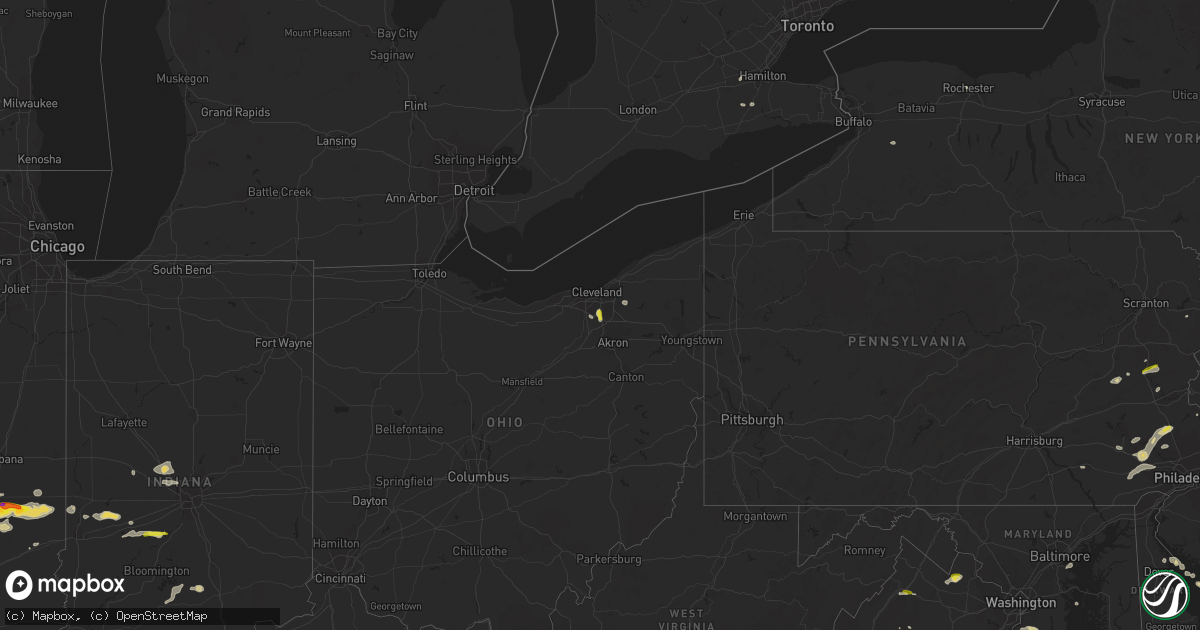
Hail Map on July 25, 2023
Get this storm
July 25 map
$229
one time, instant access
Download today. No call, no setup
Keep the $229
Bought the map and want the full workflow? Apply the entire $229 to a subscription within 7 days. None of it is wasted.
Every map, not just this one
This buys you this map. Subscription and you get every map we run, in the markets you choose from a few cities to whole states to nationwide. Plus real-time alerts the moment a storm fires.
Contact data
Name, contact info, occupancy, even credit band for addresses in the footprint. You go from where it hit to who to call.
Become the source they trust
Unlimited branding weather history reports on demand. You already have the documented answer ready for the property owner, and you are the one who showed up with it.
Property data and RoofTrace estimates
Pull up any address you have got, its value and the exact code rules for that jurisdiction, straight from One Click Code. Then RoofTrace estimates the squares, pitch, and roof value, priced the way you price.
States Impacted by Hail Map on July 25, 2023
Storm reports
Tennessee
| Date | Description |
|---|---|
| 07/25/20235:20 PM CDT | Dispatch reported 1 tree and 1 wire down along mahan gap road. Time estimated by radar. |
| 07/25/20234:41 PM CDT | Dispatch received a call for a few trees down near county road 561 and 552. |
| 07/25/20234:00 PM CDT | Dispatch reported a few trees down near the intersection of park lane and forgety road. Time estimated by radar. |
| 07/25/20233:42 PM CDT | Corrected time on previous tstm wnd dmg report from 3 ne norris. Dispatch reported a few trees down near the intersection of park lane and forgety road. Time estimated |
| 07/25/20232:40 PM CDT | 1 tree down on bluff rd. |
Maryland
| Date | Description |
|---|---|
| 07/25/20231:54 PM CDT | 911 call center reports a downed tree in greensboro. Time estimated from radar. |
| 07/25/20231:51 PM CDT | 911 call center received multiple reports of trees and wires down in ridgely. Time estimated from radar. |
| 07/25/20231:51 PM CDT | Caroline county em relayed several reports of wind damage in the town of ridgely. Damaged buildings... Trees... Down... And a roof completely lifted off of one building |
| 07/25/20231:35 PM CDT | Strong winds picked up all lawn furniture... Tore off barn roof... Vibrated windows enough to crack their seals causing water to leak inside... Knocked over 2 large bro |
| 07/25/20231:33 PM CDT | 911 call center reports a downed tree along brick schoolhouse road near centreville. Time estimated from radar. |
| 07/25/20231:33 PM CDT | 911 call center reports a downed tree along brick schoolhouse road near centreville. Time estimated from radar. |
| 07/25/20231:14 PM CDT | Wunderground station kmdsteve76 measured wind gust of 59.3mph. |
| 07/25/20231:14 PM CDT | Wunderground station kmdsteve76 measured wind gust of 59.3mph. |
| 07/25/202311:58 AM CDT | A couple trees... Large branches... And wires down between capitol heights and forestville. |
| 07/25/202311:30 AM CDT | A couple reports of trees... Branches... And wires down in the edgemere area. |
| 07/24/20237:42 PM CDT | Multiple trees... Branches... And wires down between dentsville and bryantown. |
| 07/24/20237:24 PM CDT | A couple trees and large branches down horsehead road and poplar hill road. |
Iowa
| Date | Description |
|---|---|
| 07/25/20235:03 AM CDT | Report from mping: quarter |
| 07/25/20234:40 AM CDT | Social media picture. |
| 07/25/20234:22 AM CDT | Hail lasted about 10 minutes. |
New York
| Date | Description |
|---|---|
| 07/25/20233:19 PM CDT | Multiple trees and power lines down blocking portions of route 590 in rochester. |
| 07/25/20233:15 PM CDT | Tree down onto wires on thomas street in rochester. |
| 07/25/20233:13 PM CDT | Light pole down on lake avenue in rochester. |
| 07/25/20232:40 PM CDT | Fdny reports trees down along bay ridge ave in bensonhurst between 18th and 20th ave. Social media photos depict numerous large trees down on roadway and vehicles. Time |
| 07/25/20232:40 PM CDT | Fdny reports trees down along bay ridge ave in bensonhurst between 18th and 20th ave. Social media photos depict numerous large trees down on roadway and vehicles. Time |
| 07/25/20232:37 PM CDT | Several trees and wires down near bay ridge parkway and 18th avenue. |
| 07/25/20232:37 PM CDT | Several trees and wires down near bay ridge parkway and 18th avenue. |
| 07/25/20232:29 PM CDT | Dot tree down on ny 59 eastbound between west street |
| 07/25/20232:29 PM CDT | Dot tree down on ny 59 eastbound between west street |
| 07/25/20232:11 PM CDT | Section of rt 8 between schroon river rd and tannery rd near the ymca closed due to multiple downed trees |
| 07/25/20232:11 PM CDT | Tree and wires down on kansas rd |
| 07/25/20232:09 PM CDT | Tree down across decker rd |
| 07/25/20232:03 PM CDT | Large branch across the taconic parkway |
| 07/25/20231:25 PM CDT | Tree and wires down on morton rd |
| 07/25/20231:20 PM CDT | Trees and wires down union center rd |
| 07/25/20231:14 PM CDT | Trees and wires down hardenburgh rd |
| 07/25/20231:05 PM CDT | Hail ranging in pea sized to quarter and half-dollar sized at alcove reservoir. Time estimated from radar. |
| 07/25/202311:39 AM CDT | Wires down on the roadway via county dispatch. Time estimated from radar. |
Georgia
| Date | Description |
|---|---|
| 07/25/20235:05 PM CDT | 7 to 8 trees reported down in the nw section of the county... Including west county line rd... Ga 51... And mt sinai rd. |
| 07/25/20234:57 PM CDT | A local report indicates 1.00 inch wind near 2 NNW Leaf |
Connecticut
| Date | Description |
|---|---|
| 07/25/20234:25 PM CDT | Trees and wires down across road near east street at kensington road. Relayed by amateur radio. |
Minnesota
| Date | Description |
|---|---|
| 07/25/20233:15 AM CDT | Trees and powerlines down east of hancock along county road 2. Tree down over home. Delayed report... Time estimated by radar. |
| 07/25/20231:30 AM CDT | A local report indicates 1.00 inch wind near 1 N Magnolia |
| 07/25/20231:15 AM CDT | Golf ball sized hail reported by grant county deputy... Relayed by dispatch. |
| 07/25/202312:50 AM CDT | Mesonet station mn060 e grand forks mn dot measured wind gusts ranging from 54 to 75 mph. |
| 07/25/202312:22 AM CDT | Corrects previous tstm wnd gst report from 4 n tabor. Wind gust of 63 mph was recorded at the ndawn in warren... Mn 6sw. |
| 07/25/202312:00 AM CDT | Wind gust of 63 mph was recorded at the ndawn in warren... Mn 6sw. |
| 07/24/202311:07 PM CDT | 70 to 80 mph winds reported. |
| 07/24/202311:05 PM CDT | 3-4 foot diameter trees and power poles have been snapped. Pontoons have been flipped. Some roof damage to buildings. |
| 07/24/202311:01 PM CDT | Report from mping: quarter |
| 07/24/202310:59 PM CDT | Shed destroyed... Time estimated from radar. Also report of 68 mph winds. |
| 07/24/202310:57 PM CDT | Brooten fire confirming wind gusts of 50-60 mph 5 miles south of brooten. |
| 07/24/202310:25 PM CDT | Tree down across road. Time estimated from radar. |
| 07/24/202310:20 PM CDT | Tree on powerline. Time estimated from radar. |
| 07/24/202310:20 PM CDT | A few 6-10 diameter tree branches are down in the city of chokio |
| 07/24/202310:10 PM CDT | Several trees down in town with power out. An appartment building in town had a window blow out. Also several trees down across the county. |
| 07/24/202310:08 PM CDT | Awos station kmox morris ap. |
| 07/24/202310:00 PM CDT | Corrects previous tstm wnd dmg report from chokio. Several trees and branches 6-10 diameter tree branches are down in the city of chokio |
| 07/24/20239:32 PM CDT | A report of a few fresh trees down was received via social media along the cascade river upstream of highway 61. Time estimated by radar. |
| 07/24/20239:20 PM CDT | Corrects previous hail report from 7 ene lutsen. Report of dime sized hail with up to quarter sized hailstones. |
| 07/24/20239:20 PM CDT | Corrects previous hail report from 7 ene lutsen. Report of dime sized hail with up to quarter sized hailstones. |
| 07/24/20239:20 PM CDT | One-inch tree limbs broken... Per mping report. Radar estimated time. |
| 07/24/20239:19 PM CDT | Personal weather station. |
| 07/24/20239:15 PM CDT | Corrects previous hail report from 6 ene lutsen. Report of dime sized hail with up to quarter sized hailstones. |
Indiana
| Date | Description |
|---|---|
| 07/25/202312:55 AM CDT | Quarter sized hail reported n of martinsville via social media. |
| 07/25/202312:22 AM CDT | Late report of thunderstorm winds downing trees in putnam county. Time estimated from radar. |
| 07/24/202311:37 PM CDT | Late report of thunderstorm winds downing a tree on county road 200 west. Time estimated from radar. |
Colorado
| Date | Description |
|---|---|
| 07/25/20236:00 PM CDT | Delayed report: lincoln county sheriff shared photos of numerous uprooted trees... A few broken telephone poles... Barns and sheds destroyed... Flipped over fifth wheel |
| 07/25/20235:59 PM CDT | Delayed report: spotter reported 100 mph before losing power in hugo. |
| 07/25/20235:50 PM CDT | Strong microburst winds downed trees in hugo... Some structural damage also reported. Estimated wind gusts to 60 mph. |
| 07/25/20235:23 PM CDT | Mesonet station up731 3.2 se limon |
| 07/25/20232:29 PM CDT | Awos station ktad trinidad airport. |
| 07/24/20239:02 PM CDT | Reported via kcoyuma15/rmr ranch. |
North Carolina
| Date | Description |
|---|---|
| 07/25/20232:00 PM CDT | Hail up to the size of quarters. Also strong wind but no known damage. |
Florida
| Date | Description |
|---|---|
| 07/25/20234:30 PM CDT | Thunderstorm wind gust of 59 mph measured by hand held anemometer. |
Delaware
| Date | Description |
|---|---|
| 07/25/20232:40 PM CDT | Tree down in the town of houston. Time estimated. |
| 07/25/20232:37 PM CDT | 911 call center reports a downed tree onto wires in greenwood. Time estimated from radar. |
Kentucky
| Date | Description |
|---|---|
| 07/25/20236:36 PM CDT | Quarter to half dollar sized hail. |
Massachusetts
| Date | Description |
|---|---|
| 07/25/20235:05 PM CDT | Tree down blocking loring road. Relayed by amateur radio. |
| 07/25/20233:28 PM CDT | Tree down on power lines on esther drive. Relayed by amateur radio. |
| 07/25/20233:04 PM CDT | Tree down on butternut hill in worcester. |
| 07/25/20233:00 PM CDT | Tree down block road on cardinal rd in worcester. |
| 07/25/20232:54 PM CDT | Tree down blocking lyman street near haskell street. Relayed by amateur radio. |
| 07/25/20232:34 PM CDT | Tree down on car on englewood avenue. Relayed by amateur radio. |
| 07/25/20232:30 PM CDT | Columbia road from capon street to stanwood street flooded and impassable relayed by amateur radio. |
| 07/25/20232:24 PM CDT | Tree down on chandler street. |
| 07/25/20232:07 PM CDT | Tree down on boston ave at college ave. Relayed by amateur radio. |
| 07/25/20232:05 PM CDT | Tree down blocking the road on chestnut hill avenue. Relayed by amateur radio. |
| 07/25/20232:00 PM CDT | Tree down blocking the road on newtonville ave. |
| 07/25/20232:00 PM CDT | Tree down on wires on tremont street. |
| 07/25/20232:00 PM CDT | Tree uprooted and fell on wires on beaufort circle relayed by amateur radio. |
| 07/25/20232:00 PM CDT | Tree down on henshaw terrace. |
| 07/25/20231:55 PM CDT | Tree down on car on high street. |
| 07/25/20231:50 PM CDT | Tree down blocking part of weston street. Tree down blocking road on luke road. Relayed by amateur radio. |
| 07/25/20231:40 PM CDT | Several trees down on wires and roadways in framingham relayed by amateur radio. |
| 07/25/20231:30 PM CDT | Tree fell on house on main street. |
Ohio
| Date | Description |
|---|---|
| 07/25/20231:49 PM CDT | Trees down in the chagrin falls area. Time estimated via radar. |
| 07/25/20231:46 PM CDT | Report from mping: quarter |
| 07/25/20231:37 PM CDT | Quarter sized hail reported in broadview heights. |
| 07/25/20231:31 PM CDT | Tree down on wires. Time estimated via radar. |
South Dakota
| Date | Description |
|---|---|
| 07/25/202312:20 AM CDT | Mostly nickel size hail... With a few quarters. The hail lasted for ten minutes. |
| 07/24/202311:31 PM CDT | A local report indicates 66 MPH wind near 5 SE Clayton |
| 07/24/202311:24 PM CDT | Small branches were down. |
| 07/24/202311:04 PM CDT | Measured by storm chaser. |
| 07/24/202311:02 PM CDT | Several large branches and a few trees down. |
| 07/24/202310:55 PM CDT | A local report indicates 75 MPH wind near 1 WNW Ethan |
| 07/24/202310:52 PM CDT | A local report indicates 63 MPH wind near 1 WNW Ethan |
| 07/24/202310:30 PM CDT | Social media report of widespread large tree damage and power outages in and around mt. Vernon. Time estimated by radar. |
| 07/24/202310:27 PM CDT | Trees down. |
| 07/24/202310:25 PM CDT | 69 mph wind gust at the sd mesonet station near mt vernon. |
| 07/24/202310:19 PM CDT | Measured by personal weather station. |
| 07/24/202310:14 PM CDT | Aurora county em reported quarter size hail in storla... Sd. |
| 07/24/202310:07 PM CDT | A local report indicates 70 MPH wind near 7 WSW Letcher |
| 07/24/20239:00 PM CDT | Measured on a personal weather station. |
| 07/24/20238:58 PM CDT | Mesonet station rhus2 danforth 5 e. Radar estimated time. |
| 07/24/20238:50 PM CDT | A shed was destroyed at the intersection of 215th and 369th ave. Radar estimated time. |
| 07/24/20238:49 PM CDT | Mesonet station 58 victor |
| 07/24/20238:45 PM CDT | Large tree branches broken... Grain cart tipped over. |
| 07/24/20238:45 PM CDT | Collapse of rafters on house that was being built. |
| 07/24/20238:30 PM CDT | Large tree branches down. Camp obstacle course damaged. Broken glass on a window from wind-driven hail or debris. |
| 07/24/20238:25 PM CDT | A local report indicates 63 MPH wind near Miller Dale Colony |
| 07/24/20238:20 PM CDT | Estimated 60 mph winds and up to quarter sized hail. Radar estimated time. |
Kansas
| Date | Description |
|---|---|
| 07/24/202311:25 PM CDT | Mesonet station up841 1.9 w monument |
| 07/24/202311:00 PM CDT | Delayed report via social media of thunderstorm wind gust estimated at 60+ mph between 11 to 11:15 pm cdt. |
| 07/24/202310:50 PM CDT | Asos station kgld goodland. |
| 07/24/202310:48 PM CDT | Asos station kgld goodland. |
| 07/24/202310:41 PM CDT | Mesonet station up840 9.0 w winona |
Illinois
| Date | Description |
|---|---|
| 07/24/202311:15 PM CDT | Power lines down and on fire near blackburn st on the northside of paris. |
| 07/24/202311:11 PM CDT | Relayed via broadcast media. Multiple power outages in the paris area. |
| 07/24/202310:47 PM CDT | Report from mping: quarter |
| 07/24/202310:47 PM CDT | Delayed report. Via broadcast media. |
| 07/24/202310:43 PM CDT | Relayed via broadcast media. |
| 07/24/202310:33 PM CDT | Relayed via broadcast media. |
| 07/24/202310:25 PM CDT | Delayed report. Relayed via broadcast media. |
| 07/24/20239:42 PM CDT | Delayed report. Relayed via broadcast media. |
Maine
| Date | Description |
|---|---|
| 07/25/20236:15 PM CDT | Power lines down across west hardscrabble rd. Road closed. |
| 07/25/20235:45 PM CDT | Trees and wires down on college st. |
| 07/25/20235:21 PM CDT | Multiple trees and powerlines down on bolster st. Time estimated by radar. |
| 07/25/20235:02 PM CDT | Coop observer reported large tree down on neck road. Time estimated by radar. |
| 07/25/20234:58 PM CDT | Delayed report...large snapped tree fallen on house and out building. No injuries reported. Time estimated by radar. |
| 07/25/20234:35 PM CDT | Social media photo of tree and powerline down blocking rt 202. Time estimated by radar. |
Virginia
| Date | Description |
|---|---|
| 07/25/20236:56 PM CDT | A local report indicates 1.00 inch wind near Purcellville |
| 07/25/20236:51 PM CDT | A local report indicates 1.00 inch wind near Round Hill |
| 07/25/20236:48 PM CDT | A local report indicates 1.00 inch wind near 1 W Round Hill |
| 07/25/20236:42 PM CDT | A local report indicates 1.00 inch wind near 2 ESE Bluemont |
| 07/25/20236:33 PM CDT | Tree down on powerlines on 1600 block of rockfish road |
| 07/25/20236:33 PM CDT | 2 trees down near the intersection of state route 612 and new hope-crimora road |
| 07/25/20236:23 PM CDT | Multiple trees down between the cities of verona and dooms |
| 07/25/20236:20 PM CDT | Tree down near the intersection of sperryville pike and old turnpike road |
| 07/25/20236:15 PM CDT | Tree down on the 4000 block of novum road |
| 07/25/20236:09 PM CDT | Tree down near the intersection of sperryville pike and kidwell lane |
| 07/25/20236:09 PM CDT | Multiple reports of quarter-sized hail in the verona area |
| 07/25/20236:09 PM CDT | Tree down on the 5000 block of slate mills road |
| 07/25/20235:31 PM CDT | Tree down on the 60 block of atkins road |
| 07/25/20232:52 PM CDT | A couple trees down on christians creek road near the county landfill. Several branches down nearby. |
| 07/25/20231:19 PM CDT | Powerlines and power pole down on yeatts road. |
| 07/24/20237:28 PM CDT | Quarter size hail near junction between i-66 and i-81. Relayed by skywarn coordinator. |
| 07/24/20237:06 PM CDT | Reports of multiple trees down... Storm doors blown off houses laying in streets... And a lumberyard missing a roof. First reported by broadcast meteorologist... Then c |
Nebraska
| Date | Description |
|---|---|
| 07/24/20239:38 PM CDT | Public reports rain wrapped tornado on the ground north of their location |
| 07/24/20239:25 PM CDT | Sheriff smith reports tornado on the ground... Location approximated with radar data. |
New Jersey
| Date | Description |
|---|---|
| 07/25/20232:02 PM CDT | Pictures of multiple large trees down across union township in nj. |
| 07/25/20232:02 PM CDT | Pictures of multiple large trees down across union township in nj. |
| 07/25/20231:55 PM CDT | Large tree down on kimberly court at mountain avenue in springfield nj. |
| 07/25/20231:55 PM CDT | Large tree down on kimberly court at mountain avenue in springfield nj. |
| 07/25/20231:52 PM CDT | 911 call center reports a downed tree in chatham. Time estimated from radar. |
| 07/25/20231:43 PM CDT | 911 call center reports a downed tree in randolph. Time estimated from radar. |
| 07/25/20231:36 PM CDT | Downed tree on nj 94 northbound north of nj 23 |
| 07/25/20231:34 PM CDT | Report of large branches down across hilltop rd in bernardsville. |
| 07/25/20231:29 PM CDT | 911 call center reports that several trees and wires were downed in montgomery township. Time estimated from radar. |
| 07/25/20231:20 PM CDT | Large tree down in peapack nj |
| 07/25/20231:11 PM CDT | 911 call center reports that several trees and wires were downed in hillsborough township. Time estimated from radar. |
| 07/25/20231:07 PM CDT | Several trees down near the intersection of rte 579 and rte 604 in ringoes. Time estimated. |
| 07/25/20231:05 PM CDT | Trees down in readington township. Time estimated from radar. |
| 07/25/20231:02 PM CDT | Large tree branches down on old highway 28 in mechanicsville. Time estimated. |
| 07/25/202312:57 PM CDT | Trees and wires down in west amwell township. Time estimated from radar. |
| 07/25/202312:57 PM CDT | Trees and wires down in east amwell township. Time estimated from radar. |
| 07/25/202312:53 PM CDT | Trees and wires down in raritan township. Time estimated from radar. |
| 07/25/202312:45 PM CDT | Trees down in clinton township. Time estimated from radar. |
| 07/25/202312:44 PM CDT | Trees and wires down in delaware township. Time estimated from radar. |
| 07/25/202312:40 PM CDT | Trees down in bethlehem township. Time estimated from radar. |
Pennsylvania
| Date | Description |
|---|---|
| 07/25/20232:22 PM CDT | Reports of several trees down on taylor road between downingtown and exton. |
| 07/25/202312:48 PM CDT | Trees down at quaker alley and n 6th street in stroudsburg. Time estimated from radar. |
| 07/25/202312:35 PM CDT | Trees down at hamilton elementary school in hamilton township. Time estimated from radar. |
| 07/25/202312:35 PM CDT | Trees down at twin pine and running valley roads in jackson township. Time estimated from radar. |
| 07/25/202312:35 PM CDT | Trees down along route 209 in hamilton township. Time estimated from radar. |
| 07/25/202312:27 PM CDT | Trees down at kennel and mcilhaney roads in chestnuthill township. Time estimated from radar. |
| 07/25/202312:27 PM CDT | Report from mping: trees uprooted or snapped; roof blown off. Time estimated from radar. |
| 07/25/202312:00 PM CDT | Driver observed 1 inch hail at mile marker 77 on i-476/pa turnpike northeast extension. |
| 07/25/202311:58 AM CDT | Tree down on wires in franklin township. Time estimated from radar. |
| 07/25/202311:40 AM CDT | Wires down with brush on fire near the intersection of bethlehem pike/rte 309 and rich hill road. Time estimated from radar. |
| 07/25/202311:18 AM CDT | Quarter size hail report near green lane. Power in the area is also out. |
North Dakota
| Date | Description |
|---|---|
| 07/24/20238:49 PM CDT | Wind gust measured 63 mph at dot site along the sd/nd border. |
Montana
| Date | Description |
|---|---|
| 07/24/20237:25 PM CDT | Awos station k4u6 1 e circle. |
Wisconsin
| Date | Description |
|---|---|
| 07/25/20235:35 AM CDT | Delayed report relayed via tv media. Dozens of trees down... All leaning in the same direction as the result of straight line winds. |
| 07/25/20234:36 AM CDT | Delayed damage report from overnight storms. Several trees and large limbs came down in tomah. |
| 07/25/20234:35 AM CDT | Observed 8-inch diameter maple tree snapped. |
| 07/24/20237:30 PM CDT | Via social media. Multiple trees down on property. Estimated winds to 50 mph. |
| 07/24/20237:26 PM CDT | Report from mping: trees uprooted or snapped. |
| 07/24/20237:11 PM CDT | Delayed report. Tree down on a power line. |
Cities Impacted by Hail Map on July 25, 2023
- Pennsburg, PA
- Green Lane, PA
- Lehighton, PA
- Kunkletown, PA
- Tamaqua, PA
- Shohola, PA
- Narvon, PA
- Mohnton, PA
- Perkiomenville, PA
- Sellersville, PA
- Harleysville, PA
- Telford, PA
- Douglassville, PA
- Birdsboro, PA
- Frederick, PA
- Gilbertsville, PA
- Quakertown, PA
- Palmerton, PA
- Curtis Bay, MD
- Sparrows Point, MD
- Pottstown, PA
- Royersford, PA
- Spring City, PA
- Phoenixville, PA
- Schwenksville, PA
- Chester Springs, PA
- Tuscarora, PA
- Mary D, PA
- Brockton, PA
- Coplay, PA
- Whitehall, PA
- Northampton, PA
- Broadview Heights, OH
- Brecksville, OH
- Richfield, OH
- Ramah, CO
- Calhan, CO
- Pueblo, CO
- Brant Lake, NY
- Philadelphia, TN
- Sweetwater, TN
- Corryton, TN
- Osnabrock, ND
- Nekoma, ND
- Milton, ND
- Fairdale, ND
- Owensboro, KY
- Utica, KY
- Stockton, NJ
- Frenchtown, NJ
- Eagle River, WI
- Marion, NC
- Dameron, MD
- Smyrna, DE
- Andersonville, TN
- Kerhonkson, NY
- New Hope, PA
- Lambertville, NJ
- Cleveland, GA
- Lancaster, PA
- Harriman, TN
- Kingston, TN
- Ooltewah, TN
- McDonald, TN
- Alcove, NY
- Hannacroix, NY
- Rhinebeck, NY
- Ulster Park, NY
- Staatsburg, NY
- North Royalton, OH
- Scotland, MD
- Bassett, VA
- Collinsville, VA
- Stanleytown, VA
- Cleveland, TN
- Georgetown, TN
- Glenmoore, PA
- Jim Thorpe, PA
- Loxahatchee, FL
- Cornelia, GA
- Zieglerville, PA
- Freehold, NY
- Greenville, NY
- East Durham, NY
- Greene, ME
- Lewiston, ME
- Lebanon, VA
- Gardiner, NY
- Independence, OH
- Elverson, PA
- Downingtown, PA
- Red Hill, PA
- Hilliard, FL
- Bryceville, FL
- Summit Hill, PA
- Clarkesville, GA
- Demorest, GA
- Greentown, PA
- Rochester, NY
- Sturgis, KY
- Morganfield, KY
- Crivitz, WI
- Athelstane, WI
- Oliver Springs, TN
- Vonore, TN
- Madisonville, TN
- Simla, CO
- Auburn, ME
- Castlewood, VA
- Morgantown, PA
- Edinburg, ND
- Alsen, ND
- Maynardville, TN
- Chagrin Falls, OH
- Solon, OH
- Merritt Island, FL
- South Wales, NY
- Strykersville, NY
- Thorndale, PA
- Malvern, PA
- Coatesville, PA
- Exton, PA
- Skillman, NJ
- Hopewell, NJ
- Lankin, ND
- Collegeville, PA
- Oak Ridge, TN
- Knoxville, TN
- Ringoes, NJ
- Doylestown, PA
- Englewood, TN
- Etowah, TN
- Athens, TN
- Erwinna, PA
- New Paltz, NY
- Port Ewen, NY
- Kingston, NY
- Indiantown, FL
- Stuart, FL
- Midland, VA
- Catlett, VA
- Round Hill, VA
- Purcellville, VA
- Burkesville, KY
- Middletown, VA
- Strasburg, VA
- Ree Heights, SD
- Miller, SD
- Hankinson, ND
- Ainsworth, NE
- Wessington, SD
- Saint Lawrence, SD
- Wessington Springs, SD
- Taylor, NE
- Shelbyville, IL
- Tower Hill, IL
- Plankinton, SD
- Woonsocket, SD
- Lovington, IL
- Arthur, IL
- Arcola, IL
- Findlay, IL
- Letcher, SD
- Mount Vernon, SD
- Tuscola, IL
- Hindsboro, IL
- Camargo, IL
- Mitchell, SD
- Wheaton, MN
- Morris, MN
- Dumont, MN
- Donnelly, MN
- Chokio, MN
- Graceville, MN
- Alberta, MN
- Clontarf, MN
- Hancock, MN
- Glenwood, MN
- Benson, MN
- Starbuck, MN
- Murdock, MN
- Kerkhoven, MN
- Sunburg, MN
- Danvers, MN
- Cyrus, MN
- Spicer, MN
- Willmar, MN
- Pennock, MN
- Brooten, MN
- Belgrade, MN
- New London, MN
- Ethan, SD
- Dimock, SD
- Stickney, SD
- Alexandria, SD
- Parkston, SD
- Atwater, MN
- Grove City, MN
- Paynesville, MN
- Eden Valley, MN
- Roscoe, MN
- Newman, IL
- Oakland, IL
- Brocton, IL
- Freeman, SD
- Bridgewater, SD
- Emery, SD
- Litchfield, MN
- Dalton City, IL
- Bethany, IL
- Moweaqua, IL
- Adams, ND
- Pisek, ND
- Grafton, ND
- Park River, ND
- Warren, MN
- Sperryville, VA
- Assumption, IL
- Avondale, CO
- Coleman, WI
- Pound, WI
- Highmore, SD
- La Plata, MD
- Pomfret, MD
- White Plains, MD
- Rosholt, SD
- Luray, VA
- Hatton, ND
- Reynolds, ND
- Thompson, ND
- Northwood, ND
- Front Royal, VA
- Sells, AZ
- Milnor, ND
- Finland, MN
- Waynesboro, VA
- Staunton, VA
- Stuarts Draft, VA
- Argyle, MN
- Goldvein, VA
- Karval, CO
- Long Pine, NE
- Exmore, VA
- Belle Haven, VA
- Sabattus, ME
- Charleston, IL
- Ashmore, IL
- Alvarado, MN
- Sullivan, IL
- King George, VA
- Austin, KY
- Etoile, KY
- Glasgow, KY
- Fountain Run, KY
- Verona, VA
- Minto, ND
- Wray, CO
- Gillett, WI
- Suring, WI
- Oconto Falls, WI
- Lena, WI
- Larkspur, CO
- Colorado Springs, CO
- Lidgerwood, ND
- Porcupine, SD
- Hamilton, VA
- Upperville, VA
- Bluemont, VA
- Bealeton, VA
- Carthage, IL
- Pana, IL
- Hugo, CO
- Hughesville, MD
- Waldorf, MD
- Accokeek, MD
- Brandywine, MD
- Rush, CO
- Lowry, MN
- Metcalf, IL
- Charlotte Hall, MD
- Bryantown, MD
- Faulkner, MD
- Fredericksburg, VA
- Naples, FL
- Grand Canyon, AZ
- Claire City, SD
- Akron, CO
- Miami, AZ
- Sheridan Lake, CO
- Fordville, ND
- Kandiyohi, MN
- Dassel, MN
- Watkins, MN
- Darwin, MN
- Cokato, MN
- Kimball, MN
- South Haven, MN
- Cold Spring, MN
- Richmond, MN
- Annandale, MN
- Silver Lake, MN
- Hutchinson, MN
- Howard Lake, MN
- Viborg, SD
- Clark, SD
- Vienna, SD
- Bryant, SD
- Hazel, SD
- Willow Lake, SD
- Barrett, MN
- Herman, MN
- Hoffman, MN
- Kensington, MN
- Farwell, MN
- Paullina, IA
- Primghar, IA
- Sutherland, IA
- Peterson, IA
- Linn Grove, IA
- Rembrandt, IA
- Sioux Rapids, IA
- Albert City, IA
- Storm Lake, IA
- Newell, IA
- Seymour, IN
- Wentworth, SD
- Quincy, IN
- Martinsville, IN
- Paragon, IN
- Lake Lillian, MN
- Alexandria, MN
- Clewiston, FL
- Hurley, SD
- Hinckley, OH
- Cayuga, ND
- Villard, MN
- Cottage Grove, MN
- Prescott, WI
- Hastings, MN
- Lutsen, MN
- Buffalo, MN
- Mattoon, IL
- Swanton, VT
- Saint Albans, VT
- Inver Grove Heights, MN
- South Saint Paul, MN
- Alcester, SD
- Beresford, SD
- Humboldt, IL
- Redmon, IL
- Kansas, IL
- Paris, IL
- Winona, KS
- Hager City, WI
- Ellsworth, WI
- Carbon, IN
- Reelsville, IN
- Greencastle, IN
- Rosedale, IN
- Brazil, IN
- Parkers Prairie, MN
- Vining, MN
- Freetown, IN
- Centerville, SD
- Colman, SD
- Montrose, MN
- Brownsburg, IN
- Lebanon, IN
- Zionsville, IN
- Indianapolis, IN
- Pittsboro, IN
- Clinton, IN
- Flandreau, SD
- Thief River Falls, MN
- Fairmount, ND
- New Effington, SD
- Magnolia, MN
- Adrian, MN
- Raymond, MN
- Marion, SD
- Euclid, MN
- Red Lake Falls, MN
- Luverne, MN
- Martinsville, IL
- Garretson, SD
- Kenneth, MN
- Jasper, MN
- Terre Haute, IN
- Norcross, MN
- Madison, SD
- Saint Hilaire, MN
- Cloverdale, IN
- Woodland Park, CO
- Dell Rapids, SD
- Blomkest, MN
- Poland, IN
- Bedford, IN
- Norman, IN
- Heltonville, IN
- Tofte, MN
- Hume, IL
- Immokalee, FL
- Sauk Centre, MN
- Grand Portage, MN
- Hovland, MN
- Franktown, VA
- Trent, SD
- Charlestown, IN
- Colby, KS
- Whitestown, IN
- Divide, CO
- Palmer Lake, CO
- New Ross, IN
- Crawfordsville, IN
- Brownton, MN
- Saint Paul, MN
- Livingston, WI
- Maple Lake, MN
- George, IA
- Oxford, WI
- Grand Marsh, WI
- Berlin, WI
- Grand Marais, MN
- Maiden Rock, WI
- Bay City, WI
- Wisconsin Dells, WI
- Neshkoro, WI
- Rosendale, WI
- Green Lake, WI
- Ripon, WI
- Erwin, SD
- Lake Norden, SD
- Gibbon, MN
- Wautoma, WI
- Sheldon, IA
- Friendship, WI
- Larchwood, IA
- Rock Rapids, IA
- Hills, MN
- Egan, SD
- Oakfield, WI
- Waupun, WI
- Mankato, MN
- Fonda, IA
- Pomeroy, IA
- Camp Douglas, WI
- Tomah, WI
- Marathon, IA
- Hartley, IA
- Nicollet, MN
- Courtland, MN
- Garfield, MN
- New Ulm, MN
- Wilton, WI
- Kendall, WI
- Sparta, WI
- Bernard, IA
- Mauston, WI
- Elkton, SD
- Westfield, WI
- Montello, WI
- Buffalo Lake, MN
- Cosmos, MN
- Stewart, MN
- Scales Mound, IL
- East Dubuque, IL
- Hazel Green, WI
- Galena, IL
- Beltrami, MN
- Matheson, CO
- Ashton, IA
- Redgranite, WI
- Sanborn, IA
- Arcadia, WI
- Adams, WI
- Ettrick, WI
- Royal, IA
- Archer, IA
- Laurens, IA
- Battle Lake, MN
- Clitherall, MN
- Henning, MN
- Lyndon Station, WI
- Newport, MN
- Saint Paul Park, MN
- Markesan, WI
- Dalton, WI
- Coeymans Hollow, NY
- Cairo, NY
- Surprise, NY
- Norwalk, WI
- Warrens, WI
- Hayti, SD
- Lancaster, WI
- Fennimore, WI
- Mount Hope, WI
- Fairfax, MN
- Randolph, WI
- Cambria, WI
- Friesland, WI
- Marshall, IL
- Dodge Center, MN
- New Lisbon, WI
- Elroy, WI
- Pickett, WI
- Eldorado, WI
- Brandon, WI
- Sioux Center, IA
- Orange City, IA
- Prinsburg, MN
- Cochrane, WI
- Plum City, WI
- Cascade, IA
- Galesville, WI
- Hustler, WI
- Coloma, WI
- Pemberton, MN
- Saint Clair, MN
- Janesville, MN
- Minnetonka, MN
- Wayzata, MN
- Hopkins, MN
- Rushmore, MN
- Gosport, IN