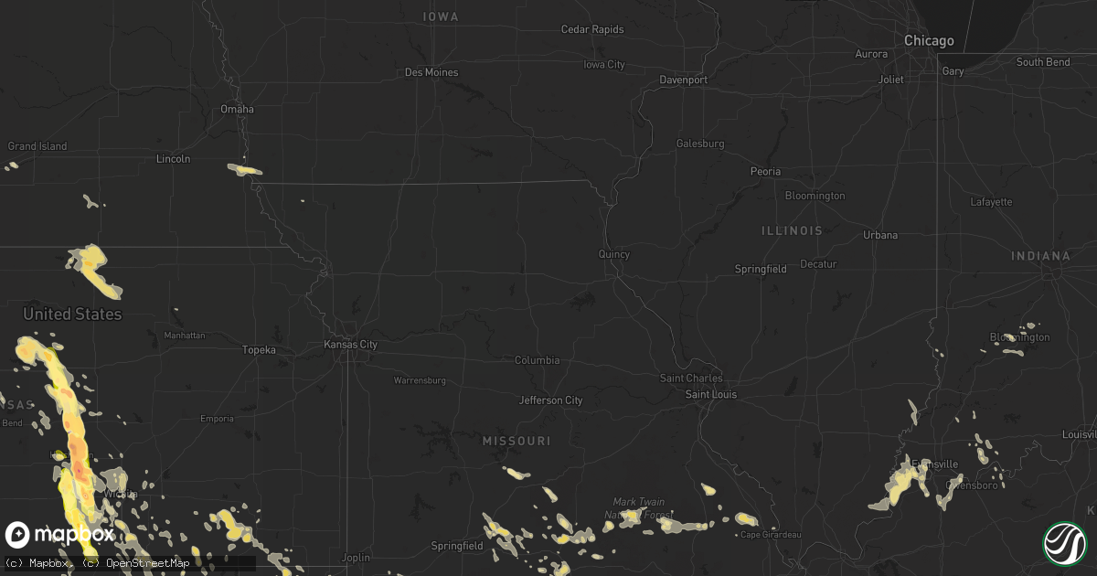
Hail Map in Nebraska on July 23, 2013
Get this storm
July 23 map
$229
one time, instant access
Download today. No call, no setup
Keep the $229
Bought the map and want the full workflow? Apply the entire $229 to a subscription within 7 days. None of it is wasted.
Every map, not just this one
This buys you this map. Subscription and you get every map we run, in the markets you choose from a few cities to whole states to nationwide. Plus real-time alerts the moment a storm fires.
Contact data
Name, contact info, occupancy, even credit band for addresses in the footprint. You go from where it hit to who to call.
Become the source they trust
Unlimited branding weather history reports on demand. You already have the documented answer ready for the property owner, and you are the one who showed up with it.
Property data and RoofTrace estimates
Pull up any address you have got, its value and the exact code rules for that jurisdiction, straight from One Click Code. Then RoofTrace estimates the squares, pitch, and roof value, priced the way you price.
Storm reports in Nebraska
Nebraska
| Date | Description |
|---|---|
| 07/23/20136:10 PM CDT | A local report indicates 1.50 inch wind near 24 W GORDON |
| 07/23/20135:50 PM CDT | A local report indicates 2.00 inch wind near 10 N HAY SPRINGS |
| 07/23/20138:45 AM CDT | Leaves stripped off of corn crop. |
| 07/22/201311:06 PM CDT | A local report indicates 1.00 inch wind near 8 WNW GURLEY |
| 07/22/201310:15 PM CDT | A local report indicates 1.75 inch wind near 9 N KIMBALL |
| 07/22/20139:40 PM CDT | Hail fell for 15 minutes. |
| 07/22/20139:16 PM CDT | A local report indicates 1.75 inch wind near 2 E BIG SPRINGS |
| 07/22/20139:13 PM CDT | Woman driving on i80 near big springs reported her windshield broken by hail. Golf ball size hail was reported 2 miles north of big springs. |
| 07/22/20139:13 PM CDT | Woman driving on i80 near big springs reported her windshield broken by hail. |
| 07/22/20139:13 PM CDT | A local report indicates 1.75 inch wind near 2 N BIG SPRINGS |
| 07/22/20139:11 PM CDT | A local report indicates 1.00 inch wind near BIG SPRINGS |
| 07/22/20139:11 PM CDT | A local report indicates 1.00 inch wind near 4 WSW BRULE |
| 07/22/20138:45 PM CDT | Leaves stripped off of corn crop. |
| 07/22/20138:37 PM CDT | A local report indicates 1.00 inch wind near 14 E OSHKOSH |
| 07/22/20138:32 PM CDT | A local report indicates 1.25 inch wind near 10 NE OSHKOSH |
| 07/22/20138:20 PM CDT | Hail stripped crop fields of corn and sudangrass. |
| 07/22/20137:20 PM CDT | A local report indicates 1.50 inch wind near ELLSWORTH |
| 07/22/20137:14 PM CDT | A local report indicates 1.00 inch wind near 40 S GORDON |
All States Impacted by Hail Map on July 23, 2013
Cities Impacted by Hail Map on July 23, 2013
- Hookstown, PA
- Georgetown, PA
- Meridian, OK
- Guthrie, OK
- Bloomington, IN
- Ola, AR
- Casa, AR
- Dorrance, KS
- Lucas, KS
- Sylvan Grove, KS
- Hay Springs, NE
- Annapolis, MO
- Vienna, GA
- Ravenna, OH
- Rootstown, OH
- Melbourne, AR
- Mountain View, AR
- Buhler, KS
- Hutchinson, KS
- Mount Hope, KS
- Inman, KS
- Haven, KS
- Dongola, IL
- Anna, IL
- Munden, KS
- Belleville, KS
- Wood River, NE
- Hope, AR
- Seymour, MO
- Norwich, KS
- Kingman, KS
- Argonia, KS
- Conway Springs, KS
- Milton, KS
- Danville, KS
- Harper, KS
- Freeport, KS
- Caldwell, KS
- Spivey, KS
- Wellston, OK
- Crescent, OK
- Cleveland, OH
- Lakewood, OH
- Liberty, IN
- Spencer, IN
- Broken Bow, OK
- Lambert, MS
- Clinton, AR
- Spearville, KS
- Hanston, KS
- Jetmore, KS
- Republic, KS
- Webber, KS
- Chadron, NE
- Ashland, KS
- Buffalo, OK
- Claremore, OK
- Chelsea, OK
- West Plains, MO
- Caulfield, MO
- Salineville, OH
- Summitville, OH
- Kensington, OH
- Lansing, MI
- East Lansing, MI
- Fairburn, SD
- Chrisney, IN
- Louisville, OH
- Alliance, OH
- Homeworth, OH
- Paris, OH
- Waynesboro, MS
- Fredericktown, MO
- Marquand, MO
- Bluffton, AR
- Hot Springs National Park, AR
- Scandia, KS
- Hamilton, OH
- Lewellen, NE
- Buffalo Gap, SD
- Shuqualak, MS
- Macon, MS
- Shirley, AR
- Fox, AR
- Dupree, SD
- Henderson, KY
- Corydon, KY
- Isabel, SD
- McLaughlin, SD
- Timber Lake, SD
- McIntosh, SD
- Lakeside, NE
- Ellsworth, NE
- Goshen, OH
- Pleasant Plain, OH
- Fayetteville, OH
- Loveland, OH
- Blanchester, OH
- Maineville, OH
- Morrow, OH
- Hartville, MO
- Marshfield, MO
- Niangua, MO
- Benton, AR
- Alexander, AR
- Traskwood, AR
- Malvern, AR
- Lonsdale, AR
- Paron, AR
- Howard, KS
- Longton, KS
- Fall River, KS
- Elk City, KS
- White River, SD
- Fort Leonard Wood, MO
- Waynesville, MO
- Adair, OK
- Tuthill, SD
- Martin, SD
- Kimbolton, OH
- Newcomerstown, OH
- Caddo Gap, AR
- Cuba, AL
- Alto Pass, IL
- Cobden, IL
- Anthony, KS
- Aliceville, AL
- Pottsville, AR
- Littlefield, AZ
- Independence, KS
- Hattieville, AR
- Solgohachia, AR
- Scotland, AR
- Morrilton, AR
- Jerusalem, AR
- Atkins, AR
- Cleveland, AR
- Black, MO
- Laquey, MO
- Garvin, OK
- Idabel, OK
- Barnsdall, OK
- Pawhuska, OK
- Lyons, KS
- Little River, KS
- Hunter, KS
- Braman, OK
- Newkirk, OK
- Blackwell, OK
- South Haven, KS
- Kenesaw, NE
- Protection, KS
- Ford, KS
- Minneola, KS
- Bucklin, KS
- Aurora, MO
- Monett, MO
- Verona, MO
- Purdy, MO
- Leupp, AZ
- Patton, MO
- Cheney, KS
- Garden Plain, KS
- Lewisville, AR
- Buckner, AR
- Stamps, AR
- Waldo, AR
- West Lafayette, OH
- Coshocton, OH
- Minco, OK
- Partridge, KS
- Abbyville, KS
- Nickerson, KS
- Ponca City, OK
- Rapid City, SD
- Keystone, SD
- Santa Claus, IN
- Lamar, IN
- Coyle, OK
- Saint Francis, SD
- Mount Vernon, IN
- Dennard, AR
- Bushnell, NE
- Harrisburg, NE
- Lesterville, MO
- Haworth, OK
- Foreman, AR
- Saint Joe, AR
- New Leipzig, ND
- Glen Ullin, ND
- Elgin, ND
- Water Valley, MS
- Okaton, SD
- Midland, SD
- Belvidere, SD
- Ivanhoe, TX
- Bonham, TX
- Ravenna, TX
- Pretty Prairie, KS
- Murdock, KS
- Milesville, SD
- Cherry Creek, SD
- Fairview, MO
- Rocky Comfort, MO
- Stella, MO
- Stark City, MO
- Wheaton, MO
- Fresno, OH
- Atlanta, KS
- Lake City, KS
- Oklahoma City, OK
- Edmond, OK
- Willow Springs, MO
- Vanzant, MO
- El Dorado, AR
- Nash, OK
- Kremlin, OK
- Medford, OK
- Pond Creek, OK
- Winfield, KS
- Geuda Springs, KS
- Arkansas City, KS
- Hammondsville, OH
- Avella, PA
- Richmond, OH
- New Cumberland, WV
- Wellsburg, WV
- Weirton, WV
- Bethany, WV
- Toronto, OH
- Irondale, OH
- Steubenville, OH
- Colliers, WV
- Follansbee, WV
- Burgettstown, PA
- Hennessey, OK
- Hoisington, KS
- Hamburg, IA
- Nebraska City, NE
- Percival, IA
- Elk Falls, KS
- Liberty, KS
- Fredonia, KS
- Neodesha, KS
- Sedan, KS
- Wright, KS
- Americus, GA
- Prattville, AL
- Autaugaville, AL
- Selma, AL
- College Corner, OH
- Strang, NE
- Bruning, NE
- Hettinger, ND
- Lemmon, SD
- Marquette, KS
- Boswell, OK
- Jessieville, AR
- Stoutland, MO
- Lebanon, MO
- Camdenton, MO
- Marshall, OK
- Newton, IL
- Cabool, MO
- Houston, MO
- Solo, MO
- Fouke, AR
- Sumner, IL
- Mansfield, MO
- Conway, MO
- Elkland, MO
- Aurora, OH
- Meadow, SD
- Meridian, MS
- Calhoun, KY
- Windom, KS
- Plato, MO
- Milan, KS
- Hermosa, SD
- Parmelee, SD
- Shidler, OK
- Defuniak Springs, FL
- Calico Rock, AR
- Sainte Genevieve, MO
- Farmington, MO
- Summersville, MO
- Hartshorn, MO
- Eminence, MO
- Newalla, OK
- Tecumseh, OK
- Mcloud, OK
- Valley Center, KS
- Belle Plaine, KS
- Wellington, KS
- Peck, KS
- Norman, AR
- Vardaman, MS
- Calhoun City, MS
- Burbank, OK
- Venango, NE
- Huntsville, AR
- Greenwood, MS
- Carrollton, MS
- Hector, AR
- Witts Springs, AR
- Pelsor, AR
- Mount Ida, AR
- Bonnerdale, AR
- Pine Ridge, SD
- Prairie Grove, AR
- West Fork, AR
- Bakersfield, MO
- Gepp, AR
- Fordyce, AR
- Ivan, AR
- Clearwater, KS
- Bunch, OK
- Stilwell, OK
- Wilmore, KS
- Lisman, AL
- Grandin, MO
- Fairfax, OK
- Ralston, OK
- Norfork, AR
- Mountain Home, AR
- Pineville, AR
- Salem, MO
- Hodgen, OK
- Heavener, OK
- Howe, OK
- Winslow, AR
- Altamont, KS
- Yukon, MO
- Wallingford, KY
- Wichita, KS
- Goddard, KS
- Camden, AL
- Bryant, AR
- Bauxite, AR
- Little Rock, AR
- Hill City, SD
- Oglala, SD
- Ozark, AR
- Montreal, MO
- Deatsville, AL
- Lead Hill, AR
- Bluff City, KS
- Manchester, OK
- Wakita, OK
- Marion, AL
- Shady Point, OK
- Poteau, OK
- Yukon, OK
- Oxford, OH
- Chickasha, OK
- Verden, OK
- Checotah, OK
- Dixons Mills, AL
- Thomasville, AL
- Oxford, MS
- Medina, OH
- Waterford, PA
- El Reno, OK
- Huntingdon, TN
- Zanesville, OH
- Roseville, OH
- Philo, OH
- Blue Rock, OH
- Mcconnelsville, OH
- Oxford, KS
- Evening Shade, AR
- Udall, KS
- Marion Junction, AL
- Welch, OK
- Catherine, AL
- Perry, AR
- Holly Pond, AL
- Pottersville, MO
- Pomona, MO
- Hughes, AR
- Amity, AR
- Lawley, AL
- Alva, OK
- Payson, AZ
- East Rochester, OH
- Brookville, KS
- Geneseo, KS
- Lincoln, KS
- Mcpherson, KS
- Kanopolis, KS
- Ellsworth, KS
- Keldron, SD
- Morristown, SD
- McKenzie, TN
- Wanette, OK
- Evansville, IN
- Cedar Vale, KS
- Kechi, KS
- Sedgwick, KS
- Maize, KS
- Bentley, KS
- Colwich, KS
- Newton, KS
- Cement, OK
- Buena Vista, TN
- Lawrenceburg, KY
- Grafton, OH
- El Dorado, KS
- Towanda, KS
- Camden, OH
- Eaton, OH
- Fort Pierre, SD
- East Liverpool, OH
- Des Arc, MO
- Ellington, MO
- Uniontown, AL
- Quitman, MS
- Nashport, OH
- Barberton, OH
- Akron, OH
- Wadsworth, OH
- Valley City, OH
- Owensboro, KY
- Reynolds Station, KY
- Hawesville, KY
- Ackerman, MS
- Derby, KS
- Cameron, OK
- Epes, AL
- Inola, OK
- Stamping Ground, KY
- Maple Heights, OH
- Arab, AL
- Wright City, OK
- Akron, AL
- Louann, AR
- Camden, AR
- Eighty Four, PA
- Bentleyville, PA
- Springdale, AR
- Fayetteville, AR
- Gamaliel, AR
- Danville, AR
- Clio, MI
- Millington, MI
- Bucyrus, MO
- Falcon, MO
- Fitzgerald, GA
- Chaparral, NM
- Georgiana, AL
- McKenzie, AL
- Dryden, MI
- Leonard, MI
- Romeo, MI
- Almont, MI
- Leon, KS
- Augusta, KS
- Alexander City, AL
- Omaha, AR
- Asher, OK
- Pittsboro, MS
- Rushville, NE
- Ratcliff, AR
- Charleston, AR
- Branch, AR
- Cecil, AR
- Mount Holly, AR
- Smackover, AR
- Burrton, KS
- South Hutchinson, KS
- Uniontown, KY
- Morganfield, KY
- Sturgis, KY
- Vinita, OK
- Moline, KS
- Otwell, IN
- Jasper, IN
- Velpen, IN
- Mabelvale, AR
- Oak Ridge, MO
- Jackson, MO
- Millersville, MO
- Marble Hill, MO
- Clifton, KS
- Clyde, KS
- Wellsville, OH
- Lisbon, OH
- Mountain Grove, MO
- Bedford, OH
- Solon, OH
- Delight, AR
- Murfreesboro, AR
- Okeana, OH
- Colquitt, GA
- Donalsonville, GA
- Faunsdale, AL
- Wilson, KS
- Poplar Bluff, MO
- Oshkosh, NE
- Brookville, IN
- Morenci, AZ
- Safford, AZ
- Concordia, KS
- Winslow, IN
- Petersburg, IN
- Minerva, OH
- Moody, MO
- Carlisle, IN
- Sullivan, IN
- Delaware, OK
- Lagrange, OH
- Frankfort, KY
- Lantry, SD
- Selfridge, ND
- Windham, OH
- Tahlequah, OK
- Hulbert, OK
- Drury, MO
- Chase, KS
- Sterling, KS
- Alden, KS
- Herod, IL
- Equality, IL
- Gainesville, MO
- Clarkridge, AR
- Miami, OK
- Newbern, AL
- Eddyville, IL
- Golconda, IL
- Hillsboro, KS
- Lehigh, KS
- Clio, AL
- Clopton, AL
- Pine Apple, AL
- Clinton, PA
- Aliquippa, PA
- Tuttle, OK
- Amber, OK
- Chagrin Falls, OH
- Carson, ND
- Honobia, OK
- Smithville, OK
- Proctor, OK
- Courtland, KS
- New Haven, KY
- Westville, OK
- Bartlett, KS
- Edna, KS
- Dora, MO
- Willisville, AR
- Rosston, AR
- Buhl, AL
- Gordo, AL
- Bardstown, KY
- Boligee, AL
- Eutaw, AL
- Sterling Heights, MI
- Warren, MI
- Greensboro, AL
- Bayard, NM
- Troy, MI
- Madison Heights, MI
- Clawson, MI
- De Kalb, MS
- Daleville, MS
- Bagdad, KY
- Shelbyville, KY
- Mountainburg, AR
- Paris, AR
- Subiaco, AR
- Heath, OH
- Mount Perry, OH
- Glenford, OH
- Thornville, OH
- Glenwood, AR
- Story, AR
- Luther, OK
- Berry, AL
- Northport, AL
- Sadieville, KY
- Greenwood, FL
- Sneads, FL
- Grand Ridge, FL
- Lenapah, OK
- Riverton, IA
- Harrisburg, IL
- Blissfield, OH
- Conesville, OH
- Warsaw, OH
- Plainfield, OH
- Dresden, OH
- Cambridge, OH
- Shenandoah, IA
- Carmen, OK
- Cherokee, OK
- Dacoma, OK
- Grove Hill, AL
- Bloomfield, IN
- Ganado, AZ
- Sebree, KY
- Slaughters, KY
- Rockport, IN
- Robards, KY
- Richland, IN
- Attica, KS
- Campbell, AL
- Dunbar, NE
- Sidney, IA
- Otoe, NE
- Batesville, MS
- Sardis, MS
- Heiskell, TN
- Clinton, TN
- Bethel, OK
- Gentry, AR
- Siloam Springs, AR
- Colcord, OK
- Batavia, OH
- Witter, AR
- Combs, AR
- Saint Paul, AR
- Scooba, MS
- Big Springs, NE
- Brule, NE
- Aline, OK
- East Canton, OH
- Red Oak, OK
- Kingsland, AR
- Merom, IN
- Tilly, AR
- Morgantown, IN
- Big Flat, AR
- Sidney, NE
- Tutwiler, MS
- Bison, OK
- De Queen, AR
- Horatio, AR
- Shawnee, OK
- Elizabethtown, IL
- Cave In Rock, IL
- Hugo, OK
- Lexington, KY
- Potwin, KS
- Cordele, GA
- Blakely, GA
- Bunker, MO
- New Haven, IL
- Junction, IL
- New Harmony, IN
- Shawneetown, IL
- Waverly, KY
- Harrodsburg, KY
- Pierce City, MO
- Viola, AR
- Brent, AL
- Forkland, AL
- Covington, OK
- Garber, OK
- Waukomis, OK
- Kingfisher, OK
- Andover, KS
- Benton, KS
- Peru, KS
- McNeil, AR
- Sallisaw, OK
- Cuyahoga Falls, OH
- Magazine, AR
- Booneville, AR
- Jakin, GA
- Cleveland, OK
- Garland City, AR
- Holcomb, MS
- Earlsboro, OK
- Maud, OK
- Alberta, AL
- Birch Tree, MO
- Cliff, NM
- Salvisa, KY
- Oral, SD
- Richland, GA
- Udall, MO
- Tecumseh, MO
- Henderson, AR
- Elizabeth, AR
- Pontiac, MO
- Jackson, AL
- Bellville, OH
- Taylor, MS
- Andale, KS
- Broxton, GA
- Denton, GA
- Rayland, OH
- Mingo Junction, OH
- Waddy, KY
- Louisville, MS
- Winona, MS
- Cincinnati, OH
- Utica, MI
- Plumerville, AR
- Pawnee, OK
- Falun, KS
- Lindsborg, KS
- Toomsuba, MS
- Gladstone, ND
- Broseley, MO
- Fisk, MO
- Afton, OK
- Tulsa, OK
- Pocahontas, AR
- Russellville, AL
- Pearcy, AR
- Bernie, MO
- Dexter, MO
- Flippin, AR
- Columbia, AL
- Buckhorn, NM
- Norman, OK
- Broken Arrow, OK
- Magnolia, AR
- Killbuck, OH
- Fredericktown, OH
- Orrville, AL
- Safford, AL
- Eunice, MO
- Crestview, FL
- Sedgewickville, MO
- Norwood, MO
- Emmet, AR
- Yellville, AR
- Valley Springs, AR
- Viola, KS
- Anadarko, OK
- Mission, SD
- Centreville, AL
- Kingston, AR
- Williams, AZ
- Vulcan, MO
- Centerville, MO
- Brookwood, AL
- Richmond, IN
- Buncombe, IL
- Vienna, IL
- Warner Robins, GA
- Arcadia, OK
- Jones, OK
- Salem, OH
- Williamsburg, OH
- Harrison, AR
- Rocky River, OH
- Bankston, AL
- Bath, IN
- West Harrison, IN
- Twin Oaks, OK
- Oglethorpe, GA
- Linden, TN
- Dolph, AR
- Guion, AR
- Hazlehurst, GA
- Coffeeville, AL
- Bartlesville, OK
- Wynona, OK
- Skiatook, OK
- Mantua, OH
- Lewisport, KY
- Elkins, AR
- Bluejacket, OK
- Burden, KS
- Rattan, OK
- Nashoba, OK
- Kirby, AR
- North Branch, MI
- Fostoria, MI
- Midway, KY
- Washington, MI
- Rochester, MI
- Cloudcroft, NM
- Unionville, IN
- Cascilla, MS
- Wister, OK
- Beverly, KS
- Haysville, KS
- Arlington, KS
- Mayfield, KS
- Mccurtain, OK
- Spavinaw, OK
- Salina, OK
- Grenola, KS
- Mount Judea, AR
- Baxley, GA
- Wesley, AR
- Hindsville, AR
- Oakland, MS
- Charleston, MS
- Robinson, IL
- Lexington, OK
- Mullinville, KS
- Bascom, FL
- Raymondville, MO
- Richland, MO
- Milton, FL
- Cannelton, IN
- Graff, MO
- Barnard, KS
- Versailles, KY
- Crooksville, OH
- Malta, OH
- Atwater, OH
- Beloit, OH
- North Benton, OH
- Berlin Center, OH
- Lower Peach Tree, AL
- Licking, MO
- Union, NE
- Vance, MS
- Rosiclare, IL
- Watauga, SD
- Merriman, NE
- New Boston, TX
- De Kalb, TX
- Lynchburg, OH
- Houston, AR
- Hadley, MI
- Lapeer, MI
- Goodrich, MI
- Metamora, MI
- Ideal, GA
- Bloomfield, NM
- Inkster, MI
- Westland, MI
- Wayne, MI
- West Chester, OH
- Fairfield, OH
- Rose Hill, KS
- Mulvane, KS
- Douglass, KS
- Union, MS
- Little Rock, MS
- Rock, KS
- Gentryville, IN
- Tennyson, IN
- Georgetown, OH
- Hamersville, OH
- Mulhall, OK
- Columbia Station, OH
- Bunker Hill, KS
- North Newton, KS
- Farragut, IA
- Dale, IN
- Ferdinand, IN
- Big Cabin, OK
- Hampton, AR
- Titus, AL
- Ellaville, GA
- Brookpark, OH
- Clinton Township, MI
- Fraser, MI
- Neosho, MO
- Blevins, AR
- Prescott, AR
- Somerville, OH
- Okarche, OK
- Watts, OK
- Kansas, OK
- Geneva, NE
- Shickley, NE
- Gallup, NM
- S Coffeyville, OK
- Coffeyville, KS
- Salina, KS
- Stigler, OK
- Morehead, KY
- Dardanelle, AR
- Shubuta, MS
- Coolidge, GA
- Rose, OK
- Abbeville, AL
- Mustang, OK
- Cashion, OK
- Piedmont, OK
- Grandview, IN
- Evanston, IN
- Lincoln City, IN
- Owensville, IN
- Allendale, IL
- Mount Carmel, IL
- Chunky, MS
- Newburg, MO
- Spurlockville, WV
- Alkol, WV
- Peterman, AL
- Monroeville, AL
- Summers, AR
- Lincoln, AR
- Belleville, AR
- Noble, OK
- Stanford, KY
- Lancaster, KY
- Danville, KY
- Everton, AR
- Hurley, NM
- Silver City, NM
- North Ridgeville, OH
- North Olmsted, OH
- Avon, OH
- Westlake, OH
- Leslie, GA
- Independence, OH
- Pettigrew, AR
- Holladay, TN
- Kennedy, AL
- Halstead, KS
- Cassville, MO
- Sidney, AR
- Formoso, KS
- Byron, NE
- Agenda, KS
- Chester, NE
- Solsberry, IN
- Pope, MS
- Courtland, MS
- Holland, IN
- Burlington Junction, MO
- Simpson, IL
- Olsburg, KS
- Cape Girardeau, MO
- Brownsville, PA
- Fredericktown, PA
- Sage, AR
- Horseshoe Bend, AR
- Franklin, AR
- Dover, OK
- Pie Town, NM
- Sardinia, OH
- Hillsboro, OH
- Ironton, MO
- Springfield, OH
- Fosters, AL
- Ralph, AL
- Glennville, GA
- Dexter, KS
- Bedford, IN
- Springville, IN
- Heltonville, IN
- Offerle, KS
- Springfield, AR
- Center Ridge, AR
- Adona, AR
- Gainestown, AL
- Raymond, KS
- Julesburg, CO
- Hanoverton, OH
- Hartville, OH
- Canton, OH
- Shell Knob, MO
- Macomb, OK
- Enterprise, MS
- Perry, OK
- Lucien, OK
- Success, MO
- Roby, MO
- Santa Teresa, NM
- Sunland Park, NM
- Boston, KY
- Midway, AR
- Lakeview, AR
- Bay Village, OH
- Beachwood, OH
- Sawyerville, AL
- Streetsboro, OH
- Kent, OH
- Lebanon, OH
- Fairland, OK
- Altoona, KS
- Parsons, TN
- Bushton, KS
- Reform, AL
- Millport, AL
- Collinsville, MS
- Bailey, MS
- Edinboro, PA
- Cambridge Springs, PA
- Imboden, AR
- Dix, NE
- Kimball, NE
- Potter, NE
- Dalton, NE
- Gurley, NE
- Midland, PA
- Ashby, NE
- Bingham, NE
- Oelrichs, SD


