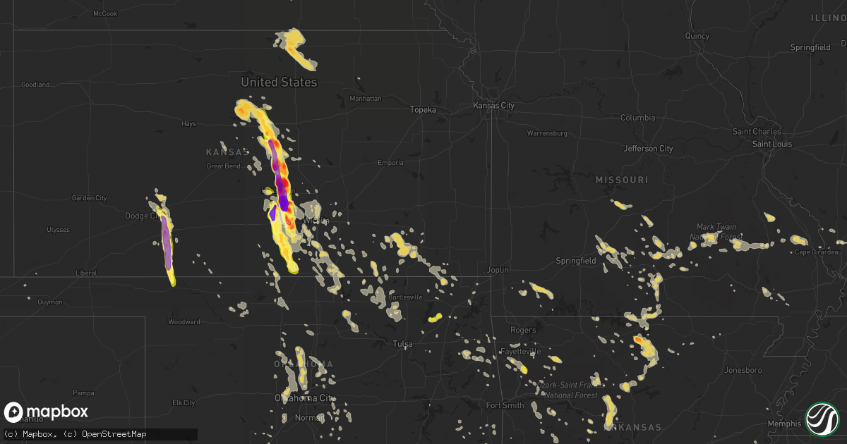
Hail Map on July 23, 2013
Get this storm
July 23 map
$229
one time, instant access
Download today. No call, no setup
Keep the $229
Bought the map and want the full workflow? Apply the entire $229 to a subscription within 7 days. None of it is wasted.
Every map, not just this one
This buys you this map. Subscription and you get every map we run, in the markets you choose from a few cities to whole states to nationwide. Plus real-time alerts the moment a storm fires.
Contact data
Name, contact info, occupancy, even credit band for addresses in the footprint. You go from where it hit to who to call.
Become the source they trust
Unlimited branding weather history reports on demand. You already have the documented answer ready for the property owner, and you are the one who showed up with it.
Property data and RoofTrace estimates
Pull up any address you have got, its value and the exact code rules for that jurisdiction, straight from One Click Code. Then RoofTrace estimates the squares, pitch, and roof value, priced the way you price.
States Impacted by Hail Map on July 23, 2013
Storm reports
Nebraska
| Date | Description |
|---|---|
| 07/23/20136:10 PM CDT | A local report indicates 1.50 inch wind near 24 W GORDON |
| 07/23/20135:50 PM CDT | A local report indicates 2.00 inch wind near 10 N HAY SPRINGS |
| 07/23/20138:45 AM CDT | Leaves stripped off of corn crop. |
| 07/22/201311:06 PM CDT | A local report indicates 1.00 inch wind near 8 WNW GURLEY |
| 07/22/201310:15 PM CDT | A local report indicates 1.75 inch wind near 9 N KIMBALL |
| 07/22/20139:40 PM CDT | Hail fell for 15 minutes. |
| 07/22/20139:16 PM CDT | A local report indicates 1.75 inch wind near 2 E BIG SPRINGS |
| 07/22/20139:13 PM CDT | Woman driving on i80 near big springs reported her windshield broken by hail. Golf ball size hail was reported 2 miles north of big springs. |
| 07/22/20139:13 PM CDT | A local report indicates 1.75 inch wind near 2 N BIG SPRINGS |
| 07/22/20139:13 PM CDT | Woman driving on i80 near big springs reported her windshield broken by hail. |
| 07/22/20139:11 PM CDT | A local report indicates 1.00 inch wind near BIG SPRINGS |
| 07/22/20139:11 PM CDT | A local report indicates 1.00 inch wind near 4 WSW BRULE |
| 07/22/20138:45 PM CDT | Leaves stripped off of corn crop. |
| 07/22/20138:37 PM CDT | A local report indicates 1.00 inch wind near 14 E OSHKOSH |
| 07/22/20138:32 PM CDT | A local report indicates 1.25 inch wind near 10 NE OSHKOSH |
| 07/22/20138:20 PM CDT | Hail stripped crop fields of corn and sudangrass. |
| 07/22/20137:20 PM CDT | A local report indicates 1.50 inch wind near ELLSWORTH |
| 07/22/20137:14 PM CDT | A local report indicates 1.00 inch wind near 40 S GORDON |
Michigan
| Date | Description |
|---|---|
| 07/23/20132:00 PM CDT | Power lines down and transformer blew. |
| 07/23/20132:00 PM CDT | A local report indicates 1.00 inch wind near CLINTION TOWNSHIP |
| 07/23/20132:00 PM CDT | A local report indicates 1.00 inch wind near CLINTON |
| 07/23/20131:00 PM CDT | Tree down |
South Dakota
| Date | Description |
|---|---|
| 07/23/20135:42 PM CDT | A local report indicates 1.50 inch wind near 6 SE FAIRBURN |
| 07/23/20135:20 PM CDT | 2 inch hail. Hail covering the ground. |
| 07/23/20135:20 PM CDT | A local report indicates 2.00 inch wind near 5 NNW FAIRBURN |
| 07/23/20135:15 PM CDT | A local report indicates 1.50 inch wind near 6 SW HERMOSA |
| 07/23/20135:15 PM CDT | A local report indicates 2.00 inch wind near 13 SSW OGLALA |
| 07/23/20134:55 PM CDT | A local report indicates 1.00 inch wind near MOUNT RUSHMORE |
| 07/23/20134:52 PM CDT | A local report indicates 1.00 inch wind near KEYSTONE |
| 07/23/20134:50 PM CDT | Catron blvd and 5th st. |
| 07/23/20134:42 PM CDT | A local report indicates 2.50 inch wind near 3 WSW SHERIDAN LAKE |
| 07/23/20134:35 PM CDT | A local report indicates 1.75 inch wind near 1 NNW SHERIDAN LAKE |
| 07/23/20134:35 PM CDT | A local report indicates 1.50 inch wind near 13 W OGLALA |
| 07/23/20134:15 PM CDT | A local report indicates 1.50 inch wind near 7 NE SMITHWICK |
| 07/23/20133:15 PM CDT | A local report indicates 1.25 inch wind near 7 W FAIRBURN |
| 07/23/20133:05 PM CDT | Half-dollar to ping-pong-ball size |
| 07/23/20135:25 AM CDT | A local report indicates 1.75 inch wind near 9 N ROSEBUD |
| 07/23/20135:00 AM CDT | A local report indicates 1.00 inch wind near 8 ENE WHITE RIVER |
| 07/23/20135:00 AM CDT | A local report indicates 1.00 inch wind near 8 W WHITE RIVER |
| 07/23/20135:00 AM CDT | A local report indicates 1.00 inch wind near 8 E WHITE RIVER |
| 07/23/20134:40 AM CDT | A local report indicates 1.75 inch wind near 14 NE BELVIDERE |
| 07/23/20134:35 AM CDT | Minor crop damage due to combination of dime sized hail and 50 mph winds. |
| 07/23/20134:30 AM CDT | A local report indicates 59 MPH wind near 10 NE BELVIDERE |
| 07/23/20134:05 AM CDT | A local report indicates 60 MPH wind near 9 NE BELVIDERE |
| 07/23/20134:05 AM CDT | A local report indicates 1.00 inch wind near 9 NE BELVIDERE |
| 07/23/20133:45 AM CDT | A local report indicates 60 MPH wind near 1 NE MIDLAND |
| 07/23/20133:45 AM CDT | A local report indicates 1.00 inch wind near 1 NE MIDLAND |
| 07/22/201311:30 PM CDT | Damage to north side of buildings |
| 07/22/201310:35 PM CDT | About 9 minutes of hail from dime to quarter size. |
| 07/22/20139:30 PM CDT | Windows broken on north side of house... Siding damaged and missing |
| 07/22/20139:30 PM CDT | Windows broken on north side of house... Siding damaged and missing |
| 07/22/20139:30 PM CDT | Mostly pea to marble size hail with a few quarter size. |
| 07/22/20138:50 PM CDT | Destoryed wheat and corn crops. 40-50 mph wind accompanied the hail. |
| 07/22/20138:08 PM CDT | Half dollar hail with a few a little bigger. |
| 07/22/20137:45 PM CDT | 1.5 inches of hail on the ground. Hail lasted 10 minutes 1845-1855 mdt |
| 07/22/20137:35 PM CDT | A local report indicates 1.50 inch wind near 3 W LEMMON |
West Virginia
| Date | Description |
|---|---|
| 07/23/20135:35 PM CDT | A local report indicates 1.25 inch wind near WEIRTON |
| 07/23/20135:30 PM CDT | A local report indicates 1.50 inch wind near WEIRTON |
| 07/23/20135:20 PM CDT | Numerous large trees and power lines down countywide |
| 07/23/20131:55 AM CDT | Trees down on power lines across crown hill drive... East back |
Massachusetts
| Date | Description |
|---|---|
| 07/23/20133:06 PM CDT | Rte 38 closed due to power lines down |
Connecticut
| Date | Description |
|---|---|
| 07/23/20135:20 PM CDT | Numerous trees down on neck road. |
| 07/23/20135:20 PM CDT | Numerous trees down on neck road. |
| 07/23/20132:35 PM CDT | Several trees down in torrington |
Pennsylvania
| Date | Description |
|---|---|
| 07/23/20136:30 PM CDT | Roof blown off home in donora. |
| 07/23/20136:22 PM CDT | Tree down in eighty four |
| 07/23/20136:15 PM CDT | Tree down in avella. |
| 07/23/20136:02 PM CDT | Trees down across the county |
| 07/23/20135:26 PM CDT | Trees and wires down along barclay ave |
| 07/23/20135:16 PM CDT | Several trees down in ridgway township on rte 948... Fork road and long level road. |
| 07/23/20135:10 PM CDT | Numerous trees down along route 120 |
| 07/23/20134:45 PM CDT | Tree down blocking scaife rd at blackburn rd |
| 07/23/20134:35 PM CDT | Trees and power lines down on us 30 near state route 168 |
| 07/23/20134:32 PM CDT | Large tree reported down on raodway |
| 07/23/20134:29 PM CDT | Trees down |
| 07/23/20134:25 PM CDT | Large tree reported |
| 07/23/20134:17 PM CDT | Large tree down on eagle rock road |
| 07/23/20134:02 PM CDT | Trees/power lines down in taylor and north beaver townships |
| 07/23/20133:52 PM CDT | Trees/power lines down in taylor and north beaver townships |
| 07/23/20133:34 PM CDT | Multiple trees down blocking one lane of i-79. |
New Mexico
| Date | Description |
|---|---|
| 07/23/20134:53 PM CDT | Grant city 911 had a lady call and say that she was at the entrance of the mine between hurley and deming and hail was coming down so hard that it cracked her windshiel |
Alabama
| Date | Description |
|---|---|
| 07/23/20135:53 PM CDT | Trees down across the county...but particularly in the southwest part. |
| 07/23/20135:20 PM CDT | Tree down on newton ave behind the ford dealership downtown ozark. |
| 07/23/20135:15 PM CDT | Tree down at rucker stables. |
| 07/23/20135:15 PM CDT | Traffic signal fell at rucker blvd. And dixie dr. |
| 07/23/20134:53 PM CDT | Wind damage and trees down at wkni radio in andalusia. |
| 07/23/20134:45 PM CDT | Trees down on power lines at cr 330. |
| 07/23/20134:45 PM CDT | County emergenecy management reported a tree down in banks. Estimated wind speed of 45-50 mph. |
| 07/23/20134:40 PM CDT | County emergency management reported trees down near hephzibah. |
| 07/23/20134:33 PM CDT | Public reported trees down near lee street and elm street in tuskegee. |
| 07/23/20134:33 PM CDT | County emergency management reported multiple trees down near south main street in tuskegee. |
| 07/23/20134:30 PM CDT | A few trees were blown down on macedonia road. |
| 07/23/20134:26 PM CDT | Swath of multiple trees down near mulberry rd./hwy 106/moore rd. |
| 07/23/20134:20 PM CDT | A few trees were blonw down in and around tallassee. |
| 07/23/20134:20 PM CDT | Tree across mount bethal road in frankville. |
| 07/23/20134:20 PM CDT | Numerous trees down in frisco city. |
| 07/23/20134:20 PM CDT | One tree down on cr 28 in saint stephens. |
| 07/23/20134:14 PM CDT | Tree down on a house in monroeville. |
| 07/23/20134:10 PM CDT | A few trees and power lines were blown down in and around coosada. |
| 07/23/20134:10 PM CDT | A tree fell on a car...trapping 4 people. |
| 07/23/20134:05 PM CDT | A few trees were blown down in and around wetumpka. |
| 07/23/20134:00 PM CDT | Trees and power lines were blown down in and around elmore. |
| 07/23/20134:00 PM CDT | Tree on building with other trees down on church street. Trees down on mount vine road and salt works road. |
| 07/23/20133:50 PM CDT | A storm chaser reported a wind gust of 62 mph in wetumpka. |
| 07/23/20133:50 PM CDT | There were multiple reports of trees down and minor structural damage in the cloverdale community in montgomery. Update...following an nws survey the winds were determi |
| 07/23/20133:45 PM CDT | Trees were blown down near lighthouse road and narrow loop. |
| 07/23/20133:43 PM CDT | Em reports tree down on brookville rd. 3 miles north of grovehill. |
| 07/23/20133:40 PM CDT | County emergency management reported trees down near highway 143 in millbrook. Additional trees were blown down in and around millbrook. |
| 07/23/20133:40 PM CDT | Trees were blown down near ingram road and myrick road. |
| 07/23/20133:39 PM CDT | County emergency management reported trees and power lines down on a house. |
| 07/23/20133:39 PM CDT | County emergency management reported trees down near harris road and politic road. |
| 07/23/20133:30 PM CDT | Em reported trees down near harris road and politic road. |
| 07/23/20133:25 PM CDT | Em reported trees down and power lines down on a house. |
| 07/23/20133:20 PM CDT | A large tree was blown down in snowdoun. |
| 07/23/20133:17 PM CDT | Report of trees down |
| 07/23/20133:10 PM CDT | Several trees were blown down along highway 14 and county road 45 west of autaugaville. |
| 07/23/20133:05 PM CDT | A few trees blown around near jones. |
| 07/23/20132:58 PM CDT | County emergency manager reported trees and power lines down in and near selma. The crown chicken building sustained roof damage and several homes were damaged by falle |
| 07/23/20132:30 PM CDT | Trees were reported down east of demopolis near arcola road and county road 2. |
| 07/23/20132:30 PM CDT | Trees reported down east of demopolis near arcola road and county road 2. |
| 07/23/20132:15 PM CDT | County emergency manager reported several trees down near cahaba beach road. |
| 07/23/20131:41 PM CDT | One tree was blown down on two cars in mountain brook. |
| 07/23/20131:21 PM CDT | County emergency manager reported trees down at romulus road and highway 82. |
| 07/23/201312:45 PM CDT | County emergency manager reported trees down near highway 18 in oakman. |
| 07/23/201312:20 PM CDT | County emergency manager reported trees down near blue ridge cutoff and highway 96. |
| 07/23/201312:20 PM CDT | County emergency manager reported trees down on highway 18 in bankston. |
| 07/23/201311:35 AM CDT | Public reported a tree down in the twin community. |
| 07/23/201311:30 AM CDT | County emergency manager reported several trees down in northern lamar county. |
| 07/23/201310:35 AM CDT | Public reported a tree down in the twin community. |
| 07/23/201310:30 AM CDT | Emergency manager reported several trees down in northern lamar county. |
| 07/23/20138:56 AM CDT | A tree was blown down on new high school street. |
Arizona
| Date | Description |
|---|---|
| 07/22/20137:00 PM CDT | Recieved call reporting large hail on hwy 191 between clifton and safford |
Oklahoma
| Date | Description |
|---|---|
| 07/23/20135:20 PM CDT | A local report indicates 60 MPH wind near 2 W CENTRAILIA |
| 07/23/20135:05 PM CDT | A local report indicates 1.00 inch wind near 4 E HUGO |
| 07/23/20134:15 PM CDT | A local report indicates 1.50 inch wind near 2 SE BOSWELL |
| 07/23/20134:10 AM CDT | Delayed report of downed trees and power lines in ardmore. Time estimated from radar. |
| 07/23/20132:55 AM CDT | Scattered wind damage in and around hugo. Some trees down completely...numerous broken limbs. Over 300 customers were without power. A few structures had roof damage. |
| 07/23/20132:25 AM CDT | Several trees down. |
| 07/23/20131:50 AM CDT | Large tree down. |
| 07/23/20131:40 AM CDT | Large tree down. Numerous large limbs down. |
| 07/23/20131:00 AM CDT | Roof blown off porch in longtown. |
| 07/23/201312:56 AM CDT | Numerous trees down. Small outbuildings severely damaged. |
| 07/23/201312:55 AM CDT | Many trees blown down. All around 12 inches in diameter. |
| 07/23/201312:54 AM CDT | Sustained wind of 54 mph with gust to 77 mph at the courthouse in eufaula. |
| 07/23/201312:52 AM CDT | Estimated wind gust to 76 mph at courthouse in eufaula. City without power. |
| 07/23/201312:52 AM CDT | Large tree limbs down in and near pawnee. |
| 07/23/201312:24 AM CDT | Several trees and power lines down |
| 07/23/201312:15 AM CDT | Trees down onto mobile homes near whitehorn cove marina. |
| 07/23/201312:11 AM CDT | Outbuilding overtunred. Section of roof blown off metal shop building. Metal storage building severely damaged. |
| 07/23/201312:06 AM CDT | A tornado tore the roof off of a large metal building...destroyed portions of two wood-framed storage units...damaged numerous homes and businesses...destroyed a travel |
| 07/23/201312:04 AM CDT | Measured thunderstorm wind of 66 mph at the hectorville mesonet. |
| 07/23/201312:00 AM CDT | Large tree limbs down at 11th and memorial. |
| 07/22/201311:59 PM CDT | 9 power poles down on 141 s. And 225 east ave...numerous trees down...some roof damage |
| 07/22/201311:50 PM CDT | Several limbs down at heritage hills golf course. |
| 07/22/201311:45 PM CDT | Numerous large tree limbs down in the cornerstone west addition. |
| 07/22/201311:45 PM CDT | Gust measured by a home weather station near 37th and nogales. |
| 07/22/201311:45 PM CDT | Public estimated 60 to 70 mph thunderstorm winds and torrential rainfall at 37th and jackson in west tulsa. |
| 07/22/201311:45 PM CDT | Large tree limbs down. |
| 07/22/201311:43 PM CDT | Measured wind gust of 60 mph at 121st and peoria. |
| 07/22/201311:42 PM CDT | Measured 76 mph winds at the tulsa international airport. |
| 07/22/201311:40 PM CDT | Several tres uprooted in round mountain area near lake keystone. |
| 07/22/201311:40 PM CDT | Measured thunderstorm wind gust at the tulsa mesonet. |
| 07/22/201311:40 PM CDT | From media at lookout mountain |
| 07/22/201311:40 PM CDT | Numerous large tree limbs and powerlines down along 86th street north around 177th street east. |
| 07/22/201311:34 PM CDT | Thunderstorm winds estimated to 60 mph. 3 inch diameter tree limbs downed. |
| 07/22/201311:30 PM CDT | A couple of trees blown down. Many large limbs broken in other trees around the area. |
| 07/22/201311:25 PM CDT | Awning and roof damage at restaurant. |
| 07/22/201311:04 PM CDT | Measured wind gust of 66 mph at wynona mesonet. |
| 07/22/201310:54 PM CDT | Measured wind gust of 73 mph at the burbank mesonet. |
| 07/22/201310:50 PM CDT | Measured wind gust of 66 mph at the foraker mesonet. |
| 07/22/201310:50 PM CDT | Large tree limbs down. |
| 07/22/201310:50 PM CDT | Measured gust of 58 mph at the burbank mesonet. |
| 07/22/201310:46 PM CDT | A local report indicates 60 MPH wind near PONCA CITY |
| 07/22/201310:34 PM CDT | A local report indicates 62 MPH wind near PONCA CITY |
| 07/22/201310:23 PM CDT | A local report indicates 75 MPH wind near 2 W BLACKWELL |
| 07/22/20139:50 PM CDT | A local report indicates 61 MPH wind near 7 SSW ALVA |
| 07/22/20139:15 PM CDT | One tree blown down and many large limbs near adair and cherokee county line along hwy 62. |
| 07/22/20139:05 PM CDT | A local report indicates 64 MPH wind near 1 SW BUFFALO |
Ohio
| Date | Description |
|---|---|
| 07/23/20135:33 PM CDT | Mostly dime sized but some quarter sized hail mixed in as well |
| 07/23/20135:22 PM CDT | A local report indicates 1.00 inch wind near TORONTO |
| 07/23/20134:49 PM CDT | Hail larger than the size of a quarter |
| 07/23/20134:40 PM CDT | Few trees reported down. |
| 07/23/20134:35 PM CDT | Nws storm survey showed a micro-burst occurred in thompson park in east liverpool. Winds were estimated to 80 to 90 mph. |
| 07/23/20134:30 PM CDT | Nws storm survey found an efo tornado touched down in carroll county ohio near the intersection of melody and appollo roads... With a path ending near 5 forks rd in fra |
| 07/23/20134:25 PM CDT | Large out building blown on to apolla and merline roads |
| 07/23/20134:25 PM CDT | Barn destroyed...roof blown off a building...silo blown over...and numerous trees down. |
| 07/23/20134:24 PM CDT | A local report indicates 1.00 inch wind near GLENDALE |
| 07/23/20134:20 PM CDT | Tree down onto car. One injury. Route 11 liverpool twp. |
| 07/23/20134:20 PM CDT | Trees down. Quarter sized hail also reported in west point. |
| 07/23/20134:11 PM CDT | A local report indicates 1.00 inch wind near EAST PALESTINE |
| 07/23/20134:10 PM CDT | Large tree down |
| 07/23/20134:03 PM CDT | A local report indicates 1.00 inch wind near 1 N WEST LAFAYETTE |
| 07/23/20133:51 PM CDT | A local report indicates 1.00 inch wind near CANAL LEWISVILLE |
| 07/23/20133:50 PM CDT | Numerous trees were downed near edenton and in wayne township. Trees were also reported down near state route 131 and the clermont...brown county border. |
| 07/23/20133:31 PM CDT | Large tree limbs downed |
| 07/23/20133:25 PM CDT | One tree two feet in diameter was downed due to thunderstorm winds. |
| 07/23/20133:20 PM CDT | Trees down all over the county. |
| 07/23/20133:20 PM CDT | A local report indicates 1.75 inch wind near REILY |
| 07/23/20133:20 PM CDT | A local report indicates 1.75 inch wind near ROSS |
| 07/23/20133:09 PM CDT | One tree down on shilow rd. In goshen |
| 07/23/20133:03 PM CDT | A local report indicates 1.00 inch wind near 1 ESE READING |
| 07/23/20133:01 PM CDT | Trees blown down and snapped off in harlan township near pleasant renner road and state rte 132. |
| 07/23/20133:00 PM CDT | Quarter size hail. |
| 07/23/20133:00 PM CDT | One large tree down and one large tree uprooted. |
| 07/23/20132:55 PM CDT | A local report indicates 1.00 inch wind near AKRON |
| 07/23/20132:50 PM CDT | One tree downed. Time estimated from radar. |
| 07/23/20132:48 PM CDT | Occurred near morrow. |
| 07/23/20132:47 PM CDT | A local report indicates 1.25 inch wind near ALLIANCE |
| 07/23/20132:45 PM CDT | Two trees reported down on property at 6470 mahoning columbiana county rd. |
| 07/23/20132:45 PM CDT | Two trees reported down on property at 6470 mahoning columbiana county rd. |
| 07/23/20132:37 PM CDT | I-70/rte 40 just east of springfield |
| 07/23/20132:17 PM CDT | A local report indicates 1.00 inch wind near 6 E MEDINA |
| 07/23/20132:00 PM CDT | Uprooted trees and large branches downed |
| 07/23/20132:00 PM CDT | A local report indicates 1.00 inch wind near 3 N MEDINA |
| 07/23/20131:35 PM CDT | Quarter size hail. |
| 07/23/20131:34 PM CDT | Pea to quarter size hail near downtown. |
| 07/23/20131:33 PM CDT | Quarter size hail. |
| 07/23/20131:23 PM CDT | A local report indicates 1.00 inch wind near CLEVELAND |
| 07/23/20131:20 PM CDT | One third of a tree split off. Via social media. |
| 07/23/20131:15 PM CDT | A local report indicates 1.00 inch wind near 1 SSE CLEVELAND |
| 07/23/20131:15 PM CDT | A local report indicates 1.00 inch wind near CLEVELAND |
Missouri
| Date | Description |
|---|---|
| 07/23/20136:30 PM CDT | Reported from iron county ems |
| 07/23/20136:23 PM CDT | A local report indicates 1.00 inch wind near ANNAPOLIS |
| 07/23/20135:19 PM CDT | A local report indicates 1.25 inch wind near 2 N HOUSTON |
| 07/23/20134:20 PM CDT | Report from social media of hail caused dents to cars and cracked a windshield. |
| 07/23/20133:25 PM CDT | A local report indicates 1.00 inch wind near BAKERSFIELD |
| 07/23/20133:10 PM CDT | Tractor trailer was blown over on highway. A building had severe damage to an outside wall. |
| 07/23/20133:07 PM CDT | A local report indicates 1.00 inch wind near WILLOW SPRINGS |
| 07/23/20132:50 PM CDT | Green house destroyed and multiple 18-inch diameter trees uprooted. Also quarter size hail occurred. |
| 07/22/20139:39 PM CDT | Trees down at roaring river state park |
| 07/22/20137:12 PM CDT | Small limbs downed by an estimated 50-60 mph winds. |
| 07/22/20137:09 PM CDT | Dime to quarter size hail reported near cc and m highway. |
Kentucky
| Date | Description |
|---|---|
| 07/22/201311:20 PM CDT | Damage to a canopy at a fuel station. |
| 07/22/201310:55 PM CDT | A local report indicates 67 MPH wind near 3 N HARRODSBURG |
| 07/22/201310:55 PM CDT | Few trees down. |
| 07/22/201310:50 PM CDT | A local report indicates 64 MPH wind near 3 N HARRODSBURG |
| 07/22/201310:10 PM CDT | A local report indicates 1.00 inch wind near LAWRENCEBURG |
| 07/22/20138:45 PM CDT | Tree limbs down across hwy 360. |
| 07/22/20138:25 PM CDT | Trees down along hwy 141. |
| 07/22/20138:25 PM CDT | Large tree and power lines donw in the community. |
| 07/22/20138:08 PM CDT | Trees and power lines down throughout the east side of town. |
| 07/22/20137:59 PM CDT | Several trees reported down in the community. |
| 07/22/20137:25 PM CDT | Large tree and power lines donw in the community. |
| 07/22/20137:09 PM CDT | Quarter size hail reported. |
Kansas
| Date | Description |
|---|---|
| 07/23/20136:57 PM CDT | A local report indicates 1.75 inch wind near WINDOM |
| 07/23/20136:57 PM CDT | A local report indicates 2.75 inch wind near 4 SE WINDOM |
| 07/23/20136:56 PM CDT | Spotter reports damaged trees and cracked windshields due to hail |
| 07/23/20136:52 PM CDT | A local report indicates 1.50 inch wind near LITTLE RIVER |
| 07/23/20136:50 PM CDT | A local report indicates 1.00 inch wind near LITTLE RIVER |
| 07/23/20136:31 PM CDT | A local report indicates 2.50 inch wind near 3 S KANOPOLIS STATE PAR |
| 07/23/20136:30 PM CDT | Several 1 inch in diameter or larger tree branches broken. |
| 07/23/20136:16 PM CDT | A local report indicates 1.75 inch wind near 10 E ELLSWORTH |
| 07/23/20136:11 PM CDT | Golf ball hail at pike and 50th road |
| 07/23/20136:06 PM CDT | Spotters yard is covered with ping pong ball to golf ball size hail |
| 07/23/20136:02 PM CDT | A local report indicates 1.25 inch wind near 8 NE ELLSWORTH |
| 07/23/20135:38 PM CDT | Ping pong and quarter size hail reported near 200th road and grain drive |
| 07/23/20135:30 PM CDT | Quarter size hail reported on highway k-14 |
| 07/23/201310:13 AM CDT | Large tree down on radio line east of c street. Time estimated from radar. |
| 07/22/201310:44 PM CDT | Damage trhoughout town with power outages. |
| 07/22/201310:28 PM CDT | 6 to 12 inch trees and power lines down with most of the city without power. Time estimated from radar. |
| 07/22/201310:18 PM CDT | 6 to 12 inch trees and power lines down with most of the city without power. Time estimated from radar. |
| 07/22/201310:18 PM CDT | A local report indicates 58 MPH wind near INDEPDENCE ARPT |
| 07/22/201310:15 PM CDT | Spotter was located at us166 and us77 |
| 07/22/201310:13 PM CDT | Large tree down on radio line east of c street. Time estimated from radar. |
| 07/22/201310:10 PM CDT | A local report indicates 64 MPH wind near 4 SE WINFIELD |
| 07/22/201310:02 PM CDT | 8 inch diameter tree blown down |
| 07/22/201310:00 PM CDT | Power lines down. Time estimated from radar |
| 07/22/20139:53 PM CDT | Powerlines and powerpoles are down around the community with power outages. Information from sumner county emergency managment facebook page. Time is estimated. |
| 07/22/20139:30 PM CDT | A local report indicates 1.00 inch wind near 3 W CONWAY SPRINGS |
| 07/22/20139:24 PM CDT | Largest tree down was 3 feet in diameter. Time estimated from radar. |
| 07/22/20139:24 PM CDT | Power lines down on main street. Time estimated from radar. |
| 07/22/20139:20 PM CDT | A local report indicates 70 MPH wind near DERBY |
| 07/22/20139:20 PM CDT | Storm siren blown over at santa fe lake. Time estimated from radar. |
| 07/22/20139:18 PM CDT | A local report indicates 60 MPH wind near ANDOVER |
| 07/22/20139:15 PM CDT | A local report indicates 66 MPH wind near MCCONNELL AIR FORCE BAS |
| 07/22/20139:14 PM CDT | Spotter reported limbs downed |
| 07/22/20139:12 PM CDT | Roof off of a 25 foot by 40 foot building along with trees and limbs down in the area. |
| 07/22/20139:11 PM CDT | A local report indicates 1.50 inch wind near NORWICH |
| 07/22/20139:11 PM CDT | A local report indicates 60 MPH wind near NORWICH |
| 07/22/20139:07 PM CDT | A local report indicates 73 MPH wind near 8 NNW NORWICH |
| 07/22/20138:53 PM CDT | A local report indicates 1.75 inch wind near 1 S CHENEY |
| 07/22/20138:52 PM CDT | Powerlines down across the roadway |
| 07/22/20138:50 PM CDT | A local report indicates 60 MPH wind near 9 SSE PRETTY PRAIRIE |
| 07/22/20138:50 PM CDT | Spotter estimated 80 to 100 mph winds |
| 07/22/20138:50 PM CDT | A local report indicates 1.00 inch wind near 9 SSE PRETTY PRAIRIE |
| 07/22/20138:44 PM CDT | A local report indicates 1.00 inch wind near PRETTY PRAIRIE |
| 07/22/20138:44 PM CDT | 8 inch tree limbs down with several on power lines. Several traffic signs down. |
| 07/22/20138:40 PM CDT | Multiple trees and limbs down in pretty prairie |
| 07/22/20138:37 PM CDT | A local report indicates 1.75 inch wind near 8 NE PRETTY PRAIRIE |
| 07/22/20138:35 PM CDT | A local report indicates 1.00 inch wind near 5 E CHENEY |
| 07/22/20138:35 PM CDT | Estimated 70 to 80 mph winds with large hail of unknown size. |
| 07/22/20138:30 PM CDT | A local report indicates 1.00 inch wind near 3 W GARDEN PLAIN |
| 07/22/20138:30 PM CDT | Estimated 60 to 65 mph winds |
| 07/22/20138:30 PM CDT | A local report indicates 2.00 inch wind near 4 ENE CHENEY |
| 07/22/20138:20 PM CDT | A local report indicates 3.00 inch wind near CHENEY |
| 07/22/20138:03 PM CDT | A local report indicates 2.50 inch wind near 6 S HAVEN |
| 07/22/20138:01 PM CDT | Tree limbs up to 2 inches in diameter were knocked down. |
| 07/22/20137:54 PM CDT | A local report indicates 2.75 inch wind near HAVEN |
| 07/22/20137:50 PM CDT | A local report indicates 2.50 inch wind near 5 WNW HAVEN |
| 07/22/20137:50 PM CDT | Nickel to quarter size hail in haven |
| 07/22/20137:47 PM CDT | Measured 4.75 inch diameter size hail. |
| 07/22/20137:44 PM CDT | A local report indicates 2.50 inch wind near YODER |
| 07/22/20137:36 PM CDT | Hail fell from 735 to 744 pm cdt. |
| 07/22/20137:35 PM CDT | Large cottonwood tree blocking 69th near old k-61 |
| 07/22/20137:35 PM CDT | Near 11th and halstead |
| 07/22/20137:35 PM CDT | A local report indicates 2.75 inch wind near 2 ESE HUTCHINSON |
| 07/22/20137:34 PM CDT | Spotter reports measured winds of 65 mph with gusts to 75 mph at 30th and hendrick |
| 07/22/20137:34 PM CDT | Winds were estimated to be in excess of 60 mph. |
| 07/22/20137:33 PM CDT | A local report indicates 1.00 inch wind near 3 WSW BUCKLIN |
| 07/22/20137:32 PM CDT | A delayed report of grapefruit size hail |
| 07/22/20137:30 PM CDT | Large section of the roof off of conklin cars at 11th and k61 |
| 07/22/20137:30 PM CDT | Baseball size hail |
| 07/22/20137:27 PM CDT | Windows damaged at the hutchinson hospital thought to be caused by hail. |
| 07/22/20137:27 PM CDT | Spotter reported tennis ball size hail falling in northeast hutchinson near power plant. |
| 07/22/20137:26 PM CDT | A local report indicates 2.50 inch wind near 2 SSW HUTCHINSON |
| 07/22/20137:25 PM CDT | A local report indicates 2.50 inch wind near 5 NE WILLOWBROOK |
| 07/22/20137:25 PM CDT | A local report indicates 60 MPH wind near BUCKLIN |
| 07/22/20137:23 PM CDT | A local report indicates 1.50 inch wind near BUHLER |
| 07/22/20137:21 PM CDT | A local report indicates 1.75 inch wind near 8 NNE WILLOWBROOK |
| 07/22/20137:20 PM CDT | Power poles were snapped and guttering was blown from a house by high winds. |
| 07/22/20137:20 PM CDT | Kwch storm chaser estimated wind gusts of 60 to 65 mph. |
| 07/22/20137:15 PM CDT | A local report indicates 2.75 inch wind near 5 SW INMAN |
| 07/22/20137:10 PM CDT | A local report indicates 60 MPH wind near 1 NE FORD |
| 07/22/20137:01 PM CDT | A local report indicates 1.75 inch wind near 15 W MCPHERSON |
Florida
| Date | Description |
|---|---|
| 07/23/20136:42 PM CDT | Trees fell on a home near peaceful lane. |
| 07/23/20136:36 PM CDT | A barn was destroyed on rolland rd. |
| 07/23/20136:36 PM CDT | One tree down on suggs rd. |
| 07/23/20136:35 PM CDT | Tree down on iron bridge rd near the chipola river. |
| 07/23/20136:34 PM CDT | Trees down all over the northern part of jackson county |
| 07/23/20136:30 PM CDT | Tree down on new hope rd near i-10. |
| 07/23/20136:24 PM CDT | 1 tree and powerline down near bruner dairy rd. |
| 07/23/20136:21 PM CDT | Tree down on county highway 81 |
| 07/23/20136:17 PM CDT | Multiple trees down on us 231 south of campbelton. |
| 07/23/20136:12 PM CDT | Tree down on county highway 183 |
| 07/23/20136:12 PM CDT | Numerous trees down countywide. A tree fell and damaged a porch in bonifay. |
| 07/23/20135:50 PM CDT | Tree across gillis drive which also took down several utility lines. Time estimated. |
| 07/23/20135:42 PM CDT | 1 tree down on cr 2a near us 331. |
| 07/23/20135:40 PM CDT | One tree down 1.5 mi n of hwy 2a 331 n. |
| 07/23/20132:45 PM CDT | Broadcast media reported tree limb down on truck at 3100 sw 23rd street. |
| 07/23/20132:12 PM CDT | Broadcast media reported tree down on road at west newberry road near alachua and gilchrist county line. |
| 07/23/201312:00 PM CDT | A very weak tornado touched down along state road 84 just northwest of the interstate 95/595 junction near marina mile. Only a couple of small boats were overturned in |
| 07/22/20137:55 PM CDT | Tree down on centerville road and cameron chase drive in tallahassee blocking the road |
| 07/22/20137:33 PM CDT | Trees down around lake talquin |
| 07/22/20137:03 PM CDT | Trees down around chattahoochee |
Arkansas
| Date | Description |
|---|---|
| 07/23/20136:20 PM CDT | A strip mall was damaged by a severe thunderstorm. In one store...a fence was blown through a roll-up door at the back of the store. The wind then traveled from back to |
| 07/23/20135:00 PM CDT | Winds were gusting 50 to 60 mph. |
| 07/23/20134:43 PM CDT | A local report indicates 60 MPH wind near MORRILTON |
| 07/23/20134:15 PM CDT | A local report indicates 1.75 inch wind near NORFORK |
| 07/23/20134:10 PM CDT | Large tree limbs were reported to be broken. |
| 07/23/20133:06 PM CDT | Large tree limbs were blown down on to a car...but the occupants were uninjured. Time is based on radar data. |
| 07/23/20132:50 PM CDT | Trees and power lines were blown down. |
| 07/23/20132:30 PM CDT | Trees were reported down around lonsdale. |
| 07/23/20132:30 PM CDT | Trees and power lines were blown down. |
| 07/23/20131:05 PM CDT | Thunderstorm winds were estimated near 60 mph along with pea size hail in crystal valley. |
| 07/22/201310:56 PM CDT | Large tree down south of town. |
| 07/22/201310:17 PM CDT | Measured wind gust of 59 mph at the rogers municipal airport. |
| 07/22/20138:15 PM CDT | Multiple large trees down |
| 07/22/20137:53 PM CDT | Trees and power lines down in the south part of the county |
| 07/22/20137:01 PM CDT | A local report indicates 1.00 inch wind near SUBIACO |
Indiana
| Date | Description |
|---|---|
| 07/23/20135:05 PM CDT | Tree down in gentryville. |
| 07/23/20132:45 PM CDT | Trees down on road in napoleon |
| 07/23/20132:00 PM CDT | Several limbs downed from a walnut tree. |
| 07/23/20131:36 PM CDT | Wires down in road at north talley and rockyford road. Time estimated based on radar. |
| 07/23/20131:35 PM CDT | Several tree branches down. |
| 07/23/20131:35 PM CDT | 1.25 inch tree branches down...not 1.25 inch hail |
| 07/23/20131:35 PM CDT | A local report indicates 1.25 inch wind near 2 E BLOOMINGTON |
| 07/23/20131:19 PM CDT | Fire department reported strong winds at the intersection of sr 67 and sr 57. Tree limbs down. |
| 07/23/20131:15 PM CDT | A few trees down southwest of bloomington |
| 07/23/20131:13 PM CDT | No damage reported |
| 07/23/20131:01 PM CDT | Large limbs and power lines down |
| 07/22/20137:09 PM CDT | Large tree limb took down power lines. Small hail reported with storm. |
Mississippi
| Date | Description |
|---|---|
| 07/23/20134:27 PM CDT | Tree down on buckatunna chicora clara rd. |
| 07/23/20134:06 PM CDT | Tree down on elbert mazingo rd. |
| 07/23/20134:02 PM CDT | Tree fell on school diesel tank in whistler. |
| 07/23/20132:45 PM CDT | Tree downed on causeyville road near the causeyville community |
| 07/23/20132:40 PM CDT | A home on 32nd street in meridian sustained roof damage due to a large oak tree falling onto it. |
| 07/23/20132:30 PM CDT | Power lines down in the north hills area of meridian |
| 07/23/20132:25 PM CDT | Trees downed on the roadway along us highway 11/80 |
| 07/23/20132:20 PM CDT | Power lines were downed on campground road |
| 07/23/20132:20 PM CDT | Trees downed around the lauderdale community |
| 07/23/20131:35 PM CDT | City official reported number of trees down across the city...and most especially at 1st and kemper streets. Windows were blown out of a car at that location as well. |
| 07/23/20131:34 PM CDT | Tree down on hwy 14 at attala/winston county line and light pole down on hwy 25 at hwy 14 intersection. |
| 07/23/20131:15 PM CDT | Reports of a few trees down on highway 145 near shuqualak. |
| 07/23/20131:05 PM CDT | A shed and a silo were damaged by strong winds |
| 07/23/201312:44 PM CDT | Trained spotter reported to local media. |
Georgia
| Date | Description |
|---|---|
| 07/23/20136:15 PM CDT | Around a dozen trees down from greston to north of chauncey...most in the eastman area. Several power outages as well. |
| 07/22/20137:12 PM CDT | Trees down in bainbridge |
Cities Impacted by Hail Map on July 23, 2013
- Hookstown, PA
- Georgetown, PA
- Meridian, OK
- Guthrie, OK
- Bloomington, IN
- Ola, AR
- Casa, AR
- Dorrance, KS
- Lucas, KS
- Sylvan Grove, KS
- Hay Springs, NE
- Annapolis, MO
- Vienna, GA
- Ravenna, OH
- Rootstown, OH
- Melbourne, AR
- Mountain View, AR
- Buhler, KS
- Hutchinson, KS
- Mount Hope, KS
- Inman, KS
- Haven, KS
- Dongola, IL
- Anna, IL
- Munden, KS
- Belleville, KS
- Wood River, NE
- Hope, AR
- Seymour, MO
- Norwich, KS
- Kingman, KS
- Argonia, KS
- Conway Springs, KS
- Milton, KS
- Danville, KS
- Harper, KS
- Freeport, KS
- Caldwell, KS
- Spivey, KS
- Wellston, OK
- Crescent, OK
- Cleveland, OH
- Lakewood, OH
- Liberty, IN
- Spencer, IN
- Broken Bow, OK
- Lambert, MS
- Clinton, AR
- Spearville, KS
- Hanston, KS
- Jetmore, KS
- Republic, KS
- Webber, KS
- Chadron, NE
- Ashland, KS
- Buffalo, OK
- Claremore, OK
- Chelsea, OK
- West Plains, MO
- Caulfield, MO
- Salineville, OH
- Summitville, OH
- Kensington, OH
- Lansing, MI
- East Lansing, MI
- Fairburn, SD
- Chrisney, IN
- Louisville, OH
- Alliance, OH
- Homeworth, OH
- Paris, OH
- Waynesboro, MS
- Fredericktown, MO
- Marquand, MO
- Bluffton, AR
- Hot Springs National Park, AR
- Scandia, KS
- Hamilton, OH
- Lewellen, NE
- Buffalo Gap, SD
- Shuqualak, MS
- Macon, MS
- Shirley, AR
- Fox, AR
- Dupree, SD
- Henderson, KY
- Corydon, KY
- Isabel, SD
- McLaughlin, SD
- Timber Lake, SD
- McIntosh, SD
- Lakeside, NE
- Ellsworth, NE
- Goshen, OH
- Pleasant Plain, OH
- Fayetteville, OH
- Loveland, OH
- Blanchester, OH
- Maineville, OH
- Morrow, OH
- Hartville, MO
- Marshfield, MO
- Niangua, MO
- Benton, AR
- Alexander, AR
- Traskwood, AR
- Malvern, AR
- Lonsdale, AR
- Paron, AR
- Howard, KS
- Longton, KS
- Fall River, KS
- Elk City, KS
- White River, SD
- Fort Leonard Wood, MO
- Waynesville, MO
- Adair, OK
- Tuthill, SD
- Martin, SD
- Kimbolton, OH
- Newcomerstown, OH
- Caddo Gap, AR
- Cuba, AL
- Alto Pass, IL
- Cobden, IL
- Anthony, KS
- Aliceville, AL
- Pottsville, AR
- Littlefield, AZ
- Independence, KS
- Hattieville, AR
- Solgohachia, AR
- Scotland, AR
- Morrilton, AR
- Jerusalem, AR
- Atkins, AR
- Cleveland, AR
- Black, MO
- Laquey, MO
- Garvin, OK
- Idabel, OK
- Barnsdall, OK
- Pawhuska, OK
- Lyons, KS
- Little River, KS
- Hunter, KS
- Braman, OK
- Newkirk, OK
- Blackwell, OK
- South Haven, KS
- Kenesaw, NE
- Protection, KS
- Ford, KS
- Minneola, KS
- Bucklin, KS
- Aurora, MO
- Monett, MO
- Verona, MO
- Purdy, MO
- Leupp, AZ
- Patton, MO
- Cheney, KS
- Garden Plain, KS
- Lewisville, AR
- Buckner, AR
- Stamps, AR
- Waldo, AR
- West Lafayette, OH
- Coshocton, OH
- Minco, OK
- Partridge, KS
- Abbyville, KS
- Nickerson, KS
- Ponca City, OK
- Rapid City, SD
- Keystone, SD
- Santa Claus, IN
- Lamar, IN
- Coyle, OK
- Saint Francis, SD
- Mount Vernon, IN
- Dennard, AR
- Bushnell, NE
- Harrisburg, NE
- Lesterville, MO
- Haworth, OK
- Foreman, AR
- Saint Joe, AR
- New Leipzig, ND
- Glen Ullin, ND
- Elgin, ND
- Water Valley, MS
- Okaton, SD
- Midland, SD
- Belvidere, SD
- Ivanhoe, TX
- Bonham, TX
- Ravenna, TX
- Pretty Prairie, KS
- Murdock, KS
- Milesville, SD
- Cherry Creek, SD
- Fairview, MO
- Rocky Comfort, MO
- Stella, MO
- Stark City, MO
- Wheaton, MO
- Fresno, OH
- Atlanta, KS
- Lake City, KS
- Oklahoma City, OK
- Edmond, OK
- Willow Springs, MO
- Vanzant, MO
- El Dorado, AR
- Nash, OK
- Kremlin, OK
- Medford, OK
- Pond Creek, OK
- Winfield, KS
- Geuda Springs, KS
- Arkansas City, KS
- Hammondsville, OH
- Avella, PA
- Richmond, OH
- New Cumberland, WV
- Wellsburg, WV
- Weirton, WV
- Bethany, WV
- Toronto, OH
- Irondale, OH
- Steubenville, OH
- Colliers, WV
- Follansbee, WV
- Burgettstown, PA
- Hennessey, OK
- Hoisington, KS
- Hamburg, IA
- Nebraska City, NE
- Percival, IA
- Elk Falls, KS
- Liberty, KS
- Fredonia, KS
- Neodesha, KS
- Sedan, KS
- Wright, KS
- Americus, GA
- Prattville, AL
- Autaugaville, AL
- Selma, AL
- College Corner, OH
- Strang, NE
- Bruning, NE
- Hettinger, ND
- Lemmon, SD
- Marquette, KS
- Boswell, OK
- Jessieville, AR
- Stoutland, MO
- Lebanon, MO
- Camdenton, MO
- Marshall, OK
- Newton, IL
- Cabool, MO
- Houston, MO
- Solo, MO
- Fouke, AR
- Sumner, IL
- Mansfield, MO
- Conway, MO
- Elkland, MO
- Aurora, OH
- Meadow, SD
- Meridian, MS
- Calhoun, KY
- Windom, KS
- Plato, MO
- Milan, KS
- Hermosa, SD
- Parmelee, SD
- Shidler, OK
- Defuniak Springs, FL
- Calico Rock, AR
- Sainte Genevieve, MO
- Farmington, MO
- Summersville, MO
- Hartshorn, MO
- Eminence, MO
- Newalla, OK
- Tecumseh, OK
- Mcloud, OK
- Valley Center, KS
- Belle Plaine, KS
- Wellington, KS
- Peck, KS
- Norman, AR
- Vardaman, MS
- Calhoun City, MS
- Burbank, OK
- Venango, NE
- Huntsville, AR
- Greenwood, MS
- Carrollton, MS
- Hector, AR
- Witts Springs, AR
- Pelsor, AR
- Mount Ida, AR
- Bonnerdale, AR
- Pine Ridge, SD
- Prairie Grove, AR
- West Fork, AR
- Bakersfield, MO
- Gepp, AR
- Fordyce, AR
- Ivan, AR
- Clearwater, KS
- Bunch, OK
- Stilwell, OK
- Wilmore, KS
- Lisman, AL
- Grandin, MO
- Fairfax, OK
- Ralston, OK
- Norfork, AR
- Mountain Home, AR
- Pineville, AR
- Salem, MO
- Hodgen, OK
- Heavener, OK
- Howe, OK
- Winslow, AR
- Altamont, KS
- Yukon, MO
- Wallingford, KY
- Wichita, KS
- Goddard, KS
- Camden, AL
- Bryant, AR
- Bauxite, AR
- Little Rock, AR
- Hill City, SD
- Oglala, SD
- Ozark, AR
- Montreal, MO
- Deatsville, AL
- Lead Hill, AR
- Bluff City, KS
- Manchester, OK
- Wakita, OK
- Marion, AL
- Shady Point, OK
- Poteau, OK
- Yukon, OK
- Oxford, OH
- Chickasha, OK
- Verden, OK
- Checotah, OK
- Dixons Mills, AL
- Thomasville, AL
- Oxford, MS
- Medina, OH
- Waterford, PA
- El Reno, OK
- Huntingdon, TN
- Zanesville, OH
- Roseville, OH
- Philo, OH
- Blue Rock, OH
- Mcconnelsville, OH
- Oxford, KS
- Evening Shade, AR
- Udall, KS
- Marion Junction, AL
- Welch, OK
- Catherine, AL
- Perry, AR
- Holly Pond, AL
- Pottersville, MO
- Pomona, MO
- Hughes, AR
- Amity, AR
- Lawley, AL
- Alva, OK
- Payson, AZ
- East Rochester, OH
- Brookville, KS
- Geneseo, KS
- Lincoln, KS
- Mcpherson, KS
- Kanopolis, KS
- Ellsworth, KS
- Keldron, SD
- Morristown, SD
- McKenzie, TN
- Wanette, OK
- Evansville, IN
- Cedar Vale, KS
- Kechi, KS
- Sedgwick, KS
- Maize, KS
- Bentley, KS
- Colwich, KS
- Newton, KS
- Cement, OK
- Buena Vista, TN
- Lawrenceburg, KY
- Grafton, OH
- El Dorado, KS
- Towanda, KS
- Camden, OH
- Eaton, OH
- Fort Pierre, SD
- East Liverpool, OH
- Des Arc, MO
- Ellington, MO
- Uniontown, AL
- Quitman, MS
- Nashport, OH
- Barberton, OH
- Akron, OH
- Wadsworth, OH
- Valley City, OH
- Owensboro, KY
- Reynolds Station, KY
- Hawesville, KY
- Ackerman, MS
- Derby, KS
- Cameron, OK
- Epes, AL
- Inola, OK
- Stamping Ground, KY
- Maple Heights, OH
- Arab, AL
- Wright City, OK
- Akron, AL
- Louann, AR
- Camden, AR
- Eighty Four, PA
- Bentleyville, PA
- Springdale, AR
- Fayetteville, AR
- Gamaliel, AR
- Danville, AR
- Clio, MI
- Millington, MI
- Bucyrus, MO
- Falcon, MO
- Fitzgerald, GA
- Chaparral, NM
- Georgiana, AL
- McKenzie, AL
- Dryden, MI
- Leonard, MI
- Romeo, MI
- Almont, MI
- Leon, KS
- Augusta, KS
- Alexander City, AL
- Omaha, AR
- Asher, OK
- Pittsboro, MS
- Rushville, NE
- Ratcliff, AR
- Charleston, AR
- Branch, AR
- Cecil, AR
- Mount Holly, AR
- Smackover, AR
- Burrton, KS
- South Hutchinson, KS
- Uniontown, KY
- Morganfield, KY
- Sturgis, KY
- Vinita, OK
- Moline, KS
- Otwell, IN
- Jasper, IN
- Velpen, IN
- Mabelvale, AR
- Oak Ridge, MO
- Jackson, MO
- Millersville, MO
- Marble Hill, MO
- Clifton, KS
- Clyde, KS
- Wellsville, OH
- Lisbon, OH
- Mountain Grove, MO
- Bedford, OH
- Solon, OH
- Delight, AR
- Murfreesboro, AR
- Okeana, OH
- Colquitt, GA
- Donalsonville, GA
- Faunsdale, AL
- Wilson, KS
- Poplar Bluff, MO
- Oshkosh, NE
- Brookville, IN
- Morenci, AZ
- Safford, AZ
- Concordia, KS
- Winslow, IN
- Petersburg, IN
- Minerva, OH
- Moody, MO
- Carlisle, IN
- Sullivan, IN
- Delaware, OK
- Lagrange, OH
- Frankfort, KY
- Lantry, SD
- Selfridge, ND
- Windham, OH
- Tahlequah, OK
- Hulbert, OK
- Drury, MO
- Chase, KS
- Sterling, KS
- Alden, KS
- Herod, IL
- Equality, IL
- Gainesville, MO
- Clarkridge, AR
- Miami, OK
- Newbern, AL
- Eddyville, IL
- Golconda, IL
- Hillsboro, KS
- Lehigh, KS
- Clio, AL
- Clopton, AL
- Pine Apple, AL
- Clinton, PA
- Aliquippa, PA
- Tuttle, OK
- Amber, OK
- Chagrin Falls, OH
- Carson, ND
- Honobia, OK
- Smithville, OK
- Proctor, OK
- Courtland, KS
- New Haven, KY
- Westville, OK
- Bartlett, KS
- Edna, KS
- Dora, MO
- Willisville, AR
- Rosston, AR
- Buhl, AL
- Gordo, AL
- Bardstown, KY
- Boligee, AL
- Eutaw, AL
- Sterling Heights, MI
- Warren, MI
- Greensboro, AL
- Bayard, NM
- Troy, MI
- Madison Heights, MI
- Clawson, MI
- De Kalb, MS
- Daleville, MS
- Bagdad, KY
- Shelbyville, KY
- Mountainburg, AR
- Paris, AR
- Subiaco, AR
- Heath, OH
- Mount Perry, OH
- Glenford, OH
- Thornville, OH
- Glenwood, AR
- Story, AR
- Luther, OK
- Berry, AL
- Northport, AL
- Sadieville, KY
- Greenwood, FL
- Sneads, FL
- Grand Ridge, FL
- Lenapah, OK
- Riverton, IA
- Harrisburg, IL
- Blissfield, OH
- Conesville, OH
- Warsaw, OH
- Plainfield, OH
- Dresden, OH
- Cambridge, OH
- Shenandoah, IA
- Carmen, OK
- Cherokee, OK
- Dacoma, OK
- Grove Hill, AL
- Bloomfield, IN
- Ganado, AZ
- Sebree, KY
- Slaughters, KY
- Rockport, IN
- Robards, KY
- Richland, IN
- Attica, KS
- Campbell, AL
- Dunbar, NE
- Sidney, IA
- Otoe, NE
- Batesville, MS
- Sardis, MS
- Heiskell, TN
- Clinton, TN
- Bethel, OK
- Gentry, AR
- Siloam Springs, AR
- Colcord, OK
- Batavia, OH
- Witter, AR
- Combs, AR
- Saint Paul, AR
- Scooba, MS
- Big Springs, NE
- Brule, NE
- Aline, OK
- East Canton, OH
- Red Oak, OK
- Kingsland, AR
- Merom, IN
- Tilly, AR
- Morgantown, IN
- Big Flat, AR
- Sidney, NE
- Tutwiler, MS
- Bison, OK
- De Queen, AR
- Horatio, AR
- Shawnee, OK
- Elizabethtown, IL
- Cave In Rock, IL
- Hugo, OK
- Lexington, KY
- Potwin, KS
- Cordele, GA
- Blakely, GA
- Bunker, MO
- New Haven, IL
- Junction, IL
- New Harmony, IN
- Shawneetown, IL
- Waverly, KY
- Harrodsburg, KY
- Pierce City, MO
- Viola, AR
- Brent, AL
- Forkland, AL
- Covington, OK
- Garber, OK
- Waukomis, OK
- Kingfisher, OK
- Andover, KS
- Benton, KS
- Peru, KS
- McNeil, AR
- Sallisaw, OK
- Cuyahoga Falls, OH
- Magazine, AR
- Booneville, AR
- Jakin, GA
- Cleveland, OK
- Garland City, AR
- Holcomb, MS
- Earlsboro, OK
- Maud, OK
- Alberta, AL
- Birch Tree, MO
- Cliff, NM
- Salvisa, KY
- Oral, SD
- Richland, GA
- Udall, MO
- Tecumseh, MO
- Henderson, AR
- Elizabeth, AR
- Pontiac, MO
- Jackson, AL
- Bellville, OH
- Taylor, MS
- Andale, KS
- Broxton, GA
- Denton, GA
- Rayland, OH
- Mingo Junction, OH
- Waddy, KY
- Louisville, MS
- Winona, MS
- Cincinnati, OH
- Utica, MI
- Plumerville, AR
- Pawnee, OK
- Falun, KS
- Lindsborg, KS
- Toomsuba, MS
- Gladstone, ND
- Broseley, MO
- Fisk, MO
- Afton, OK
- Tulsa, OK
- Pocahontas, AR
- Russellville, AL
- Pearcy, AR
- Bernie, MO
- Dexter, MO
- Flippin, AR
- Columbia, AL
- Buckhorn, NM
- Norman, OK
- Broken Arrow, OK
- Magnolia, AR
- Killbuck, OH
- Fredericktown, OH
- Orrville, AL
- Safford, AL
- Eunice, MO
- Crestview, FL
- Sedgewickville, MO
- Norwood, MO
- Emmet, AR
- Yellville, AR
- Valley Springs, AR
- Viola, KS
- Anadarko, OK
- Mission, SD
- Centreville, AL
- Kingston, AR
- Williams, AZ
- Vulcan, MO
- Centerville, MO
- Brookwood, AL
- Richmond, IN
- Buncombe, IL
- Vienna, IL
- Warner Robins, GA
- Arcadia, OK
- Jones, OK
- Salem, OH
- Williamsburg, OH
- Harrison, AR
- Rocky River, OH
- Bankston, AL
- Bath, IN
- West Harrison, IN
- Twin Oaks, OK
- Oglethorpe, GA
- Linden, TN
- Dolph, AR
- Guion, AR
- Hazlehurst, GA
- Coffeeville, AL
- Bartlesville, OK
- Wynona, OK
- Skiatook, OK
- Mantua, OH
- Lewisport, KY
- Elkins, AR
- Bluejacket, OK
- Burden, KS
- Rattan, OK
- Nashoba, OK
- Kirby, AR
- North Branch, MI
- Fostoria, MI
- Midway, KY
- Washington, MI
- Rochester, MI
- Cloudcroft, NM
- Unionville, IN
- Cascilla, MS
- Wister, OK
- Beverly, KS
- Haysville, KS
- Arlington, KS
- Mayfield, KS
- Mccurtain, OK
- Spavinaw, OK
- Salina, OK
- Grenola, KS
- Mount Judea, AR
- Baxley, GA
- Wesley, AR
- Hindsville, AR
- Oakland, MS
- Charleston, MS
- Robinson, IL
- Lexington, OK
- Mullinville, KS
- Bascom, FL
- Raymondville, MO
- Richland, MO
- Milton, FL
- Cannelton, IN
- Graff, MO
- Barnard, KS
- Versailles, KY
- Crooksville, OH
- Malta, OH
- Atwater, OH
- Beloit, OH
- North Benton, OH
- Berlin Center, OH
- Lower Peach Tree, AL
- Licking, MO
- Union, NE
- Vance, MS
- Rosiclare, IL
- Watauga, SD
- Merriman, NE
- New Boston, TX
- De Kalb, TX
- Lynchburg, OH
- Houston, AR
- Hadley, MI
- Lapeer, MI
- Goodrich, MI
- Metamora, MI
- Ideal, GA
- Bloomfield, NM
- Inkster, MI
- Westland, MI
- Wayne, MI
- West Chester, OH
- Fairfield, OH
- Rose Hill, KS
- Mulvane, KS
- Douglass, KS
- Union, MS
- Little Rock, MS
- Rock, KS
- Gentryville, IN
- Tennyson, IN
- Georgetown, OH
- Hamersville, OH
- Mulhall, OK
- Columbia Station, OH
- Bunker Hill, KS
- North Newton, KS
- Farragut, IA
- Dale, IN
- Ferdinand, IN
- Big Cabin, OK
- Hampton, AR
- Titus, AL
- Ellaville, GA
- Brookpark, OH
- Clinton Township, MI
- Fraser, MI
- Neosho, MO
- Blevins, AR
- Prescott, AR
- Somerville, OH
- Okarche, OK
- Watts, OK
- Kansas, OK
- Geneva, NE
- Shickley, NE
- Gallup, NM
- S Coffeyville, OK
- Coffeyville, KS
- Salina, KS
- Stigler, OK
- Morehead, KY
- Dardanelle, AR
- Shubuta, MS
- Coolidge, GA
- Rose, OK
- Abbeville, AL
- Mustang, OK
- Cashion, OK
- Piedmont, OK
- Grandview, IN
- Evanston, IN
- Lincoln City, IN
- Owensville, IN
- Allendale, IL
- Mount Carmel, IL
- Chunky, MS
- Newburg, MO
- Spurlockville, WV
- Alkol, WV
- Peterman, AL
- Monroeville, AL
- Summers, AR
- Lincoln, AR
- Belleville, AR
- Noble, OK
- Stanford, KY
- Lancaster, KY
- Danville, KY
- Everton, AR
- Hurley, NM
- Silver City, NM
- North Ridgeville, OH
- North Olmsted, OH
- Avon, OH
- Westlake, OH
- Leslie, GA
- Independence, OH
- Pettigrew, AR
- Holladay, TN
- Kennedy, AL
- Halstead, KS
- Cassville, MO
- Sidney, AR
- Formoso, KS
- Byron, NE
- Agenda, KS
- Chester, NE
- Solsberry, IN
- Pope, MS
- Courtland, MS
- Holland, IN
- Burlington Junction, MO
- Simpson, IL
- Olsburg, KS
- Cape Girardeau, MO
- Brownsville, PA
- Fredericktown, PA
- Sage, AR
- Horseshoe Bend, AR
- Franklin, AR
- Dover, OK
- Pie Town, NM
- Sardinia, OH
- Hillsboro, OH
- Ironton, MO
- Springfield, OH
- Fosters, AL
- Ralph, AL
- Glennville, GA
- Dexter, KS
- Bedford, IN
- Springville, IN
- Heltonville, IN
- Offerle, KS
- Springfield, AR
- Center Ridge, AR
- Adona, AR
- Gainestown, AL
- Raymond, KS
- Julesburg, CO
- Hanoverton, OH
- Hartville, OH
- Canton, OH
- Shell Knob, MO
- Macomb, OK
- Enterprise, MS
- Perry, OK
- Lucien, OK
- Success, MO
- Roby, MO
- Santa Teresa, NM
- Sunland Park, NM
- Boston, KY
- Midway, AR
- Lakeview, AR
- Bay Village, OH
- Beachwood, OH
- Sawyerville, AL
- Streetsboro, OH
- Kent, OH
- Lebanon, OH
- Fairland, OK
- Altoona, KS
- Parsons, TN
- Bushton, KS
- Reform, AL
- Millport, AL
- Collinsville, MS
- Bailey, MS
- Edinboro, PA
- Cambridge Springs, PA
- Imboden, AR
- Dix, NE
- Kimball, NE
- Potter, NE
- Dalton, NE
- Gurley, NE
- Midland, PA
- Ashby, NE
- Bingham, NE
- Oelrichs, SD