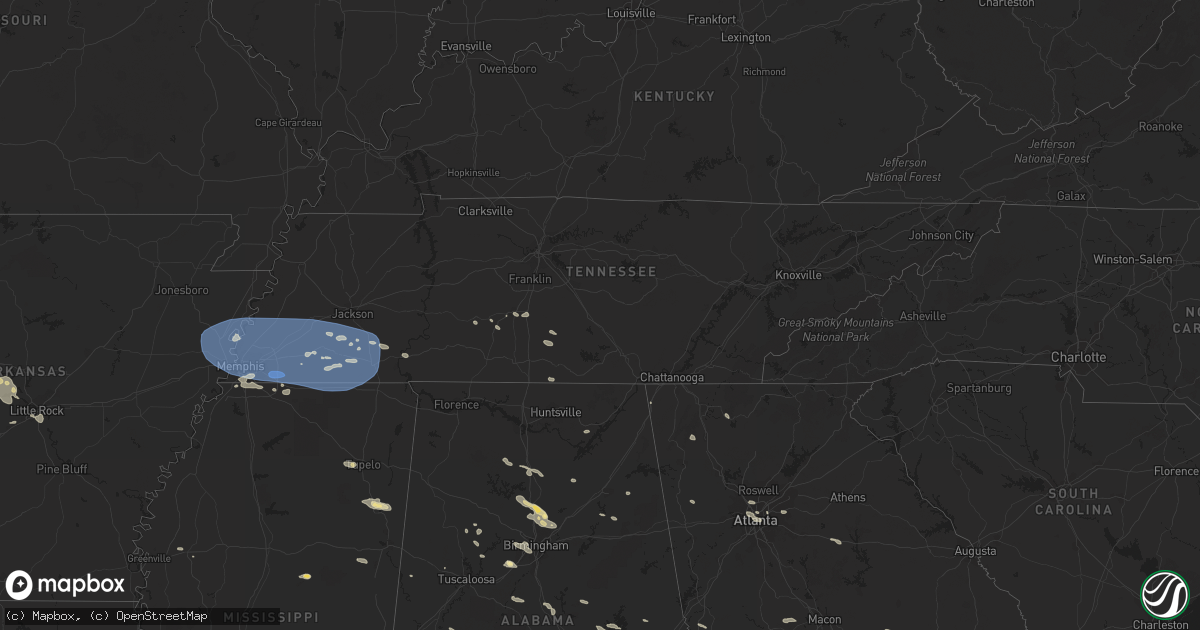
Hail Map in Tennessee on July 21, 2023
Get this storm
July 21 map
$229
one time, instant access
Download today. No call, no setup
Keep the $229
Bought the map and want the full workflow? Apply the entire $229 to a subscription within 7 days. None of it is wasted.
Every map, not just this one
This buys you this map. Subscription and you get every map we run, in the markets you choose from a few cities to whole states to nationwide. Plus real-time alerts the moment a storm fires.
Contact data
Name, contact info, occupancy, even credit band for addresses in the footprint. You go from where it hit to who to call.
Become the source they trust
Unlimited branding weather history reports on demand. You already have the documented answer ready for the property owner, and you are the one who showed up with it.
Property data and RoofTrace estimates
Pull up any address you have got, its value and the exact code rules for that jurisdiction, straight from One Click Code. Then RoofTrace estimates the squares, pitch, and roof value, priced the way you price.
Storm reports in Tennessee
Tennessee
| Date | Description |
|---|---|
| 07/21/20234:25 PM CDT | A tree was blown down onto a garage and two cars along beartown road. |
| 07/21/20234:25 PM CDT | A tree fell on power lines on 3rd street in lawrenceburg. |
| 07/21/20234:21 PM CDT | A tree was blown down across road near the intersection of s old military road and fairview road. |
| 07/21/20233:33 PM CDT | Trees down on a house with 4 occupants inside. Occupants un-injured. Time is radar estimated. |
| 07/21/20233:27 PM CDT | Nursing home in savannah is without power due to trees down and transformers are sparking on sterling lane. Time is radar estimated. |
| 07/21/20233:25 PM CDT | 60 mph wind gust measured on weather station. |
| 07/21/20233:25 PM CDT | Trees down... A possible vehicle accident due to trees down... Power outages across hardin county. Time is radar estimated. |
| 07/21/20233:20 PM CDT | Tree on house on woodland dr in henderson. Relayed by media. Time is radar estimated. |
| 07/21/20232:28 PM CDT | Tree on house on college st. In whiteville. Widespread trees and powerlines down across the county. |
| 07/21/20232:24 PM CDT | Tree on house in germantown. |
| 07/21/20232:16 PM CDT | Trees down across haywood county. |
| 07/21/20232:14 PM CDT | Tree down blocking both lanes across hwy 57 in the 11200 block... East of rossville. Time is radar estimated. |
| 07/21/20232:11 PM CDT | Powerline down on greenleaf cemetery road. |
| 07/21/20232:02 PM CDT | Tree down across mt. Carmel rd just north of waley lane. Time is radar estimated. |
| 07/21/20232:01 PM CDT | Power lines down in the 4300 block of marshall rd. Time is radar indicated. |
| 07/21/20232:00 PM CDT | Trees down. Time is radar estimated. |
| 07/21/20231:58 PM CDT | Measured wind gust. Snapped 3 inch flag pole. |
| 07/21/20231:55 PM CDT | Tree down on powerline on holmes road west of forest wind dr. |
| 07/21/20231:54 PM CDT | Corrects previous tstm wnd dmg report from 2 wnw germantown. Tree on house in germantown. |
| 07/21/20231:52 PM CDT | Numerous trees down across the southern half of tipton county. |
| 07/21/20231:43 PM CDT | Trees down across parts of austin peay - east of millington; along pleasant ridge & raleigh-millington road. Time is radar estimated. |
| 07/21/20231:43 PM CDT | *** 1 inj *** corrects previous tstm wnd dmg report from 3 n southeast memphis. Tree fell on car on park avenue. Time is radar estimated. 1 injury. |
| 07/21/20231:43 PM CDT | Bartlett pd reports ivanhoe rd at kenwood cv impassable due to tree down. Time is radar estimated. |
| 07/21/20231:40 PM CDT | Tree on two vehicles on allison ave in binghampton. Time is radar estimated. |
All States Impacted by Hail Map on July 21, 2023
Cities Impacted by Hail Map on July 21, 2023
- Roland, AR
- Bigelow, AR
- Ola, AR
- Fort Smith, AR
- Morrilton, AR
- Adona, AR
- Perryville, AR
- Houston, AR
- Perry, AR
- Charleston, AR
- Lavaca, AR
- Magazine, AR
- Southaven, MS
- Olive Branch, MS
- Horn Lake, MS
- Little Rock, AR
- Plainview, AR
- Bryant, AR
- Alexander, AR
- Benton, AR
- Mayflower, AR
- Paron, AR
- Earle, AR
- West Memphis, AR
- Drummonds, TN
- Bassett, AR
- Marion, AR
- Wilson, AR
- Millington, TN
- Frenchmans Bayou, AR
- Tyronza, AR
- Joiner, AR
- Memphis, TN
- Crawfordsville, AR
- Gilmore, AR
- Turrell, AR
- Munford, TN
- Covington, TN
- Brighton, TN
- Burlison, TN
- Atoka, TN
- Stanton, TN
- Brownsville, TN
- Mason, TN
- Arlington, TN
- Cordova, TN
- Williston, TN
- Somerville, TN
- Collierville, TN
- Eads, TN
- Rossville, TN
- Oakland, TN
- Germantown, TN
- Moscow, TN
- Proctor, AR
- Dyess, AR
- Medon, TN
- Pinson, TN
- Henderson, TN
- Grand Junction, TN
- Jackson, TN
- Bolivar, TN
- Denmark, TN
- Mercer, TN
- Toone, TN
- Whiteville, TN
- Hickory Valley, TN
- Bethel Springs, TN
- Michigan City, MS
- Pocahontas, TN
- Walnut, MS
- Hornsby, TN
- Finger, TN
- Falkner, MS
- Tiplersville, MS
- Saulsbury, TN
- Middleton, TN
- La Grange, TN
- Ashland, MS
- Selmer, TN
- Lamar, MS
- Holly Springs, MS
- Byhalia, MS
- Alburgh, VT
- Ramer, TN
- Adamsville, TN
- Corinth, MS
- Brookline, NH
- Hollis, NH
- Ocate, NM
- Guadalupita, NM
- Las Vegas, NM
- Mora, NM
- Rociada, NM
- Sapello, NM
- Montezuma, NM
- Rapid City, SD
- Hermosa, SD
- Pavillion, WY
- Red Banks, MS
- South Hero, VT
- Williamstown, MA
- Aberdeen, MS
- Amory, MS
- Leominster, MA
- West Townsend, MA
- Townsend, MA
- Hayden, AL
- Bremen, AL
- Hanceville, AL
- Wendell, MA
- Los Alamos, NM
- Shelburne Falls, MA
- South Deerfield, MA
- Williamsburg, MA
- Ashfield, MA
- Conway, MA
- Deerfield, MA
- Columbia, TN
- Stone Mountain, GA
- Decatur, GA
- Atkins, AR
- Atlanta, GA
- Fayetteville, TN
- Taft, TN
- Buffalo, WY
- Belfast, TN
- Petersburg, TN
- Enterprise, MS
- Hickory, MS
- Chatsworth, GA
- Park Valley, UT
- Snowville, UT
- Tupelo, MS
- Lunenburg, MA
- Fitchburg, MA
- Westminster, MA
- Ashby, MA
- Lilburn, GA
- Snellville, GA
- Cimarron, NM
- Princeton, MA
- Pepperell, MA
- Chaplin, CT
- Mansfield Center, CT
- Storrs Mansfield, CT
- Montague, MA
- Zolfo Springs, FL
- Erving, MA
- Okolona, MS
- Vinemont, AL
- Addison, AL
- Danville, AL
- Fort Lauderdale, FL
- Walls, MS
- Cullman, AL
- Grant, AL
- Woodville, AL
- Sylacauga, AL
- Weogufka, AL
- Pontotoc, MS
- Calhoun, GA
- Armuchee, GA
- Downey, ID
- Champlain, NY
- Indianola, MS
- Rising Fawn, GA
- Shirley, MA
- Dunstable, MA
- Ashburnham, MA
- Hubbardston, MA
- Groton, MA
- Venus, FL
- Moore Haven, FL
- Crump, TN
- Savannah, TN
- Shelbyville, TN
- Lewisburg, TN
- Belden, MS
- Hohenwald, TN
- Volin, SD
- Mission Hill, SD
- Gayville, SD
- Whitewood, SD
- Sturgis, SD
- Deadwood, SD
- New Raymer, CO
- Stoneham, CO
- Merino, CO
- Raton, NM
- Conchas Dam, NM
- Tucumcari, NM
- Greeley, CO
- Kersey, CO
- Gill, CO
- Mcalister, NM
- Wellington, CO
- Cheyenne, WY
- Carr, CO
- Nunn, CO
- Johnstown, NE
- Ainsworth, NE
- Brewster, NE
- Purdum, NE
- Melrose, NM
- Floyd, NM
- Grover, CO
- Ault, CO
- Lander, WY
- Dunning, NE
- Cleveland, NM
- Sunderland, MA
- Irene, SD
- Fairburn, SD
- North Franklin, CT
- Willimantic, CT
- Windham, CT
- Lebanon, CT
- South Windham, CT
- Tyngsboro, MA
- Westford, MA
- Brookwood, AL
- McCalla, AL
- Bessemer, AL
- Bairoil, WY
- Wamsutter, WY
- Moriarty, NM
- Ware, MA
- Colchester, VT
- Burlington, VT
- Balaton, MN
- Perry, GA
- Fort Valley, GA
- Vienna, GA
- Preston, ID
- Briggsdale, CO
- East Dublin, GA
- Rockmart, GA
- Cedartown, GA
- Arabi, GA
- Berry, AL
- Easthampton, MA
- Flandreau, SD
- Elkton, SD
- Aiken, SC
- Pleasant Grove, AL
- Birmingham, AL
- Fairfield, AL
- Mulga, AL
- Dolomite, AL
- Mount Pleasant, TN
- House, NM
- Stanley, NM
- McCool, MS
- Gray Court, SC
- Enoree, SC
- Ponderosa, NM
- Snyder, CO
- Marshallville, GA
- Reynolds, GA
- Union, SC
- Dudley, GA
- Montrose, GA
- Dublin, GA
- Southampton, MA
- Holyoke, MA
- South Hadley, MA
- Florence, MA
- Watrous, NM
- Pine Hill, AL
- Thomasville, AL
- Centreville, AL
- Brierfield, AL
- Penasco, NM
- Kathleen, GA
- Crawford, MS
- Starkville, MS
- Auburn, AL
- Pinson, AL
- Morris, AL
- Sawyerville, AL
- Waverly, AL
- Camp Hill, AL
- Thomaston, AL
- Arlington, AL
- Gordo, AL
- Granite Canon, WY
- Arcadia, FL
- Pipestone, MN
- Lowell, MA
- Hadley, MA
- Northampton, MA
- Hatfield, MA
- West Hatfield, MA
- Plainville, GA
- La Salle, CO
- Hampton, CT
- Warrior, AL
- Valentine, NE
- Mission, SD
- Nashua, NH
- Linden, AL
- Magnolia, AL
- West Point, GA
- Hamilton, GA
- Clanton, AL
- Rutland, MA
- Evans, CO
- Adams, MA
- Pauline, SC
- Buffalo, SC
- Dry Branch, GA
- Bonaire, GA
- Trafford, AL
- Kimberly, AL
- Lamy, NM
- Elgin, AZ
- Wood Lake, NE
- Guilford, CT
- Oakman, AL
- Pena Blanca, NM
- Cochiti Pueblo, NM
- Equality, AL
- Alexander City, AL
- Dadeville, AL
- Thorndike, MA
- Belchertown, MA
- Palmer, MA
- Bondsville, MA
- Moorhead, MS
- Inverness, MS
- Marietta, GA
- Weir, MS
- Sparks, NE
- Adger, AL
- Hope Hull, AL
- Montgomery, AL
- Young, AZ
- Ohatchee, AL
- Ragland, AL
- Piedmont, AL
- Gadsden, AL
- Alexandria, AL
- Anniston, AL
- Summerville, GA
- Ridgeville, SC
- Cusseta, GA
- Tennille, GA
- Madison, GA
- Orrville, AL
- Safford, AL
- Scenic, SD
- Keystone, SD
- North Haven, CT
- East Haven, CT
- Branford, CT
- Hamden, CT
- New Haven, CT
- North Branford, CT
- Woodbridge, CT
- Northford, CT
- Catherine, AL
- Granby, MA
- Ludlow, MA
- Three Rivers, MA
- New Salem, MA
- Alamo, GA
- Tombstone, AZ
- Higdon, AL
- Flat Rock, AL
- Trenton, GA
- Douglas, AZ
- Devens, MA
- Ayer, MA
- Wetumpka, AL
- Tallassee, AL
- Eclectic, AL
- Box Springs, GA
- Jemison, AL
- Northport, AL
- Camden, AL
- Florissant, CO
- Glenwood, GA
- Carrollton, AL
- Altoona, AL
- Gardner, MA
- Acton, MA
- Littleton, MA
- Boxborough, MA
- Harvard, MA
- Lancaster, MA
- Trussville, AL
- Gardendale, AL
- Pennington, AL
- Musella, GA
- Jacksonville, GA
- Viborg, SD
- Salem, SD
- Tuscaloosa, AL
- Ellerslie, GA
- Midland, GA
- Cataula, GA
- Upatoi, GA
- Rockledge, GA
- Cambridge, MA
- Somerville, MA
- Boston, MA
- Charlestown, MA
- East Boston, MA
- Everett, MA
- Chelsea, MA
- Roswell, NM
- North Brookfield, MA
- Callaway, NE
- Monument, CO
- Fitzgerald, GA
- Rebecca, GA
- Ocilla, GA
- Colorado Springs, CO
- Franktown, CO
- Larkspur, CO
- Lynn, MA
- Revere, MA
- Saugus, MA
- Nahant, MA
- Abbeville, AL
- Adrian, GA
- Guffey, CO
- Elbert, CO
- Arlington, GA
- Encino, NM
- Blakely, GA
- Fort Gaines, GA
- Bluffton, GA
- Coleman, GA
- Ashburn, GA
- Fort Sumner, NM
- Leesburg, GA
- Holliston, MA
- Cross, SC
- Arnold, NE
- Hartsel, CO
- Pinopolis, SC
- South Boston, MA
- Hull, MA
- Orchard, CO
- Matheson, CO
- Cripple Creek, CO
- Denton, GA
- Hazlehurst, GA
- Cordele, GA
- Columbia, AL
- Brookline, MA
- Swampscott, MA
- Malden, MA
- Roxbury Crossing, MA
- Winthrop, MA
- West Brookfield, MA
- Warren, MA
- Mount Vernon, GA
- Norway, SC
- Anselmo, NE
- Clarkston, GA
- Scottdale, GA
- Elida, NM
- Albany, GA
- Newton, GA
- Shorterville, AL
- Rochelle, GA
- Pine Apple, AL
- Sylvester, GA
- Cuthbert, GA
- Red Level, AL
- Rainsville, NM
- Weston, GA
- Richland, GA
- Plantersville, AL
- Selma, AL
- Lumpkin, GA
- Dixons Mills, AL
- Castle Rock, CO


