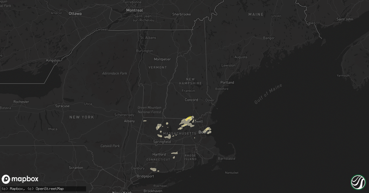
Hail Map in New Hampshire on July 21, 2023
Get this storm
July 21 map
$229
one time, instant access
Download today. No call, no setup
Keep the $229
Bought the map and want the full workflow? Apply the entire $229 to a subscription within 7 days. None of it is wasted.
Every map, not just this one
This buys you this map. Subscription and you get every map we run, in the markets you choose from a few cities to whole states to nationwide. Plus real-time alerts the moment a storm fires.
Contact data
Name, contact info, occupancy, even credit band for addresses in the footprint. You go from where it hit to who to call.
Become the source they trust
Unlimited branding weather history reports on demand. You already have the documented answer ready for the property owner, and you are the one who showed up with it.
Property data and RoofTrace estimates
Pull up any address you have got, its value and the exact code rules for that jurisdiction, straight from One Click Code. Then RoofTrace estimates the squares, pitch, and roof value, priced the way you price.
Storm reports in New Hampshire
New Hampshire
| Date | Description |
|---|---|
| 07/21/20233:56 PM CDT | Delayed report...hail fell in vicinity of nashua airport for 7-8 minutes. Estimated at quarter size. |
| 07/21/20233:50 PM CDT | Delayed report...a few trees down on pine hill rd. |
| 07/21/20233:46 PM CDT | A local report indicates 1.25 inch wind near 1 W Hollis |
| 07/21/20233:46 PM CDT | Delayed report...trained spotter observed downed trees and larges branches around greeley park and other parts of north nashua. |
| 07/21/20233:40 PM CDT | Trees down on lake potanipo and nh hwy 130 in brookline with diameters of 7-10 inches. Small hail also reported. |
| 07/21/20233:32 PM CDT | Delayed report...uprooted tree partially blocking wheeler rd near apple tree farm. |
All States Impacted by Hail Map on July 21, 2023
Cities Impacted by Hail Map on July 21, 2023
- Roland, AR
- Bigelow, AR
- Ola, AR
- Fort Smith, AR
- Morrilton, AR
- Adona, AR
- Perryville, AR
- Houston, AR
- Perry, AR
- Charleston, AR
- Lavaca, AR
- Magazine, AR
- Southaven, MS
- Olive Branch, MS
- Horn Lake, MS
- Little Rock, AR
- Plainview, AR
- Bryant, AR
- Alexander, AR
- Benton, AR
- Mayflower, AR
- Paron, AR
- Earle, AR
- West Memphis, AR
- Drummonds, TN
- Bassett, AR
- Marion, AR
- Wilson, AR
- Millington, TN
- Frenchmans Bayou, AR
- Tyronza, AR
- Joiner, AR
- Memphis, TN
- Crawfordsville, AR
- Gilmore, AR
- Turrell, AR
- Munford, TN
- Covington, TN
- Brighton, TN
- Burlison, TN
- Atoka, TN
- Stanton, TN
- Brownsville, TN
- Mason, TN
- Arlington, TN
- Cordova, TN
- Williston, TN
- Somerville, TN
- Collierville, TN
- Eads, TN
- Rossville, TN
- Oakland, TN
- Germantown, TN
- Moscow, TN
- Proctor, AR
- Dyess, AR
- Medon, TN
- Pinson, TN
- Henderson, TN
- Grand Junction, TN
- Jackson, TN
- Bolivar, TN
- Denmark, TN
- Mercer, TN
- Toone, TN
- Whiteville, TN
- Hickory Valley, TN
- Bethel Springs, TN
- Michigan City, MS
- Pocahontas, TN
- Walnut, MS
- Hornsby, TN
- Finger, TN
- Falkner, MS
- Tiplersville, MS
- Saulsbury, TN
- Middleton, TN
- La Grange, TN
- Ashland, MS
- Selmer, TN
- Lamar, MS
- Holly Springs, MS
- Byhalia, MS
- Alburgh, VT
- Ramer, TN
- Adamsville, TN
- Corinth, MS
- Brookline, NH
- Hollis, NH
- Ocate, NM
- Guadalupita, NM
- Las Vegas, NM
- Mora, NM
- Rociada, NM
- Sapello, NM
- Montezuma, NM
- Rapid City, SD
- Hermosa, SD
- Pavillion, WY
- Red Banks, MS
- South Hero, VT
- Williamstown, MA
- Aberdeen, MS
- Amory, MS
- Leominster, MA
- West Townsend, MA
- Townsend, MA
- Hayden, AL
- Bremen, AL
- Hanceville, AL
- Wendell, MA
- Los Alamos, NM
- Shelburne Falls, MA
- South Deerfield, MA
- Williamsburg, MA
- Ashfield, MA
- Conway, MA
- Deerfield, MA
- Columbia, TN
- Stone Mountain, GA
- Decatur, GA
- Atkins, AR
- Atlanta, GA
- Fayetteville, TN
- Taft, TN
- Buffalo, WY
- Belfast, TN
- Petersburg, TN
- Enterprise, MS
- Hickory, MS
- Chatsworth, GA
- Park Valley, UT
- Snowville, UT
- Tupelo, MS
- Lunenburg, MA
- Fitchburg, MA
- Westminster, MA
- Ashby, MA
- Lilburn, GA
- Snellville, GA
- Cimarron, NM
- Princeton, MA
- Pepperell, MA
- Chaplin, CT
- Mansfield Center, CT
- Storrs Mansfield, CT
- Montague, MA
- Zolfo Springs, FL
- Erving, MA
- Okolona, MS
- Vinemont, AL
- Addison, AL
- Danville, AL
- Fort Lauderdale, FL
- Walls, MS
- Cullman, AL
- Grant, AL
- Woodville, AL
- Sylacauga, AL
- Weogufka, AL
- Pontotoc, MS
- Calhoun, GA
- Armuchee, GA
- Downey, ID
- Champlain, NY
- Indianola, MS
- Rising Fawn, GA
- Shirley, MA
- Dunstable, MA
- Ashburnham, MA
- Hubbardston, MA
- Groton, MA
- Venus, FL
- Moore Haven, FL
- Crump, TN
- Savannah, TN
- Shelbyville, TN
- Lewisburg, TN
- Belden, MS
- Hohenwald, TN
- Volin, SD
- Mission Hill, SD
- Gayville, SD
- Whitewood, SD
- Sturgis, SD
- Deadwood, SD
- New Raymer, CO
- Stoneham, CO
- Merino, CO
- Raton, NM
- Conchas Dam, NM
- Tucumcari, NM
- Greeley, CO
- Kersey, CO
- Gill, CO
- Mcalister, NM
- Wellington, CO
- Cheyenne, WY
- Carr, CO
- Nunn, CO
- Johnstown, NE
- Ainsworth, NE
- Brewster, NE
- Purdum, NE
- Melrose, NM
- Floyd, NM
- Grover, CO
- Ault, CO
- Lander, WY
- Dunning, NE
- Cleveland, NM
- Sunderland, MA
- Irene, SD
- Fairburn, SD
- North Franklin, CT
- Willimantic, CT
- Windham, CT
- Lebanon, CT
- South Windham, CT
- Tyngsboro, MA
- Westford, MA
- Brookwood, AL
- McCalla, AL
- Bessemer, AL
- Bairoil, WY
- Wamsutter, WY
- Moriarty, NM
- Ware, MA
- Colchester, VT
- Burlington, VT
- Balaton, MN
- Perry, GA
- Fort Valley, GA
- Vienna, GA
- Preston, ID
- Briggsdale, CO
- East Dublin, GA
- Rockmart, GA
- Cedartown, GA
- Arabi, GA
- Berry, AL
- Easthampton, MA
- Flandreau, SD
- Elkton, SD
- Aiken, SC
- Pleasant Grove, AL
- Birmingham, AL
- Fairfield, AL
- Mulga, AL
- Dolomite, AL
- Mount Pleasant, TN
- House, NM
- Stanley, NM
- McCool, MS
- Gray Court, SC
- Enoree, SC
- Ponderosa, NM
- Snyder, CO
- Marshallville, GA
- Reynolds, GA
- Union, SC
- Dudley, GA
- Montrose, GA
- Dublin, GA
- Southampton, MA
- Holyoke, MA
- South Hadley, MA
- Florence, MA
- Watrous, NM
- Pine Hill, AL
- Thomasville, AL
- Centreville, AL
- Brierfield, AL
- Penasco, NM
- Kathleen, GA
- Crawford, MS
- Starkville, MS
- Auburn, AL
- Pinson, AL
- Morris, AL
- Sawyerville, AL
- Waverly, AL
- Camp Hill, AL
- Thomaston, AL
- Arlington, AL
- Gordo, AL
- Granite Canon, WY
- Arcadia, FL
- Pipestone, MN
- Lowell, MA
- Hadley, MA
- Northampton, MA
- Hatfield, MA
- West Hatfield, MA
- Plainville, GA
- La Salle, CO
- Hampton, CT
- Warrior, AL
- Valentine, NE
- Mission, SD
- Nashua, NH
- Linden, AL
- Magnolia, AL
- West Point, GA
- Hamilton, GA
- Clanton, AL
- Rutland, MA
- Evans, CO
- Adams, MA
- Pauline, SC
- Buffalo, SC
- Dry Branch, GA
- Bonaire, GA
- Trafford, AL
- Kimberly, AL
- Lamy, NM
- Elgin, AZ
- Wood Lake, NE
- Guilford, CT
- Oakman, AL
- Pena Blanca, NM
- Cochiti Pueblo, NM
- Equality, AL
- Alexander City, AL
- Dadeville, AL
- Thorndike, MA
- Belchertown, MA
- Palmer, MA
- Bondsville, MA
- Moorhead, MS
- Inverness, MS
- Marietta, GA
- Weir, MS
- Sparks, NE
- Adger, AL
- Hope Hull, AL
- Montgomery, AL
- Young, AZ
- Ohatchee, AL
- Ragland, AL
- Piedmont, AL
- Gadsden, AL
- Alexandria, AL
- Anniston, AL
- Summerville, GA
- Ridgeville, SC
- Cusseta, GA
- Tennille, GA
- Madison, GA
- Orrville, AL
- Safford, AL
- Scenic, SD
- Keystone, SD
- North Haven, CT
- East Haven, CT
- Branford, CT
- Hamden, CT
- New Haven, CT
- North Branford, CT
- Woodbridge, CT
- Northford, CT
- Catherine, AL
- Granby, MA
- Ludlow, MA
- Three Rivers, MA
- New Salem, MA
- Alamo, GA
- Tombstone, AZ
- Higdon, AL
- Flat Rock, AL
- Trenton, GA
- Douglas, AZ
- Devens, MA
- Ayer, MA
- Wetumpka, AL
- Tallassee, AL
- Eclectic, AL
- Box Springs, GA
- Jemison, AL
- Northport, AL
- Camden, AL
- Florissant, CO
- Glenwood, GA
- Carrollton, AL
- Altoona, AL
- Gardner, MA
- Acton, MA
- Littleton, MA
- Boxborough, MA
- Harvard, MA
- Lancaster, MA
- Trussville, AL
- Gardendale, AL
- Pennington, AL
- Musella, GA
- Jacksonville, GA
- Viborg, SD
- Salem, SD
- Tuscaloosa, AL
- Ellerslie, GA
- Midland, GA
- Cataula, GA
- Upatoi, GA
- Rockledge, GA
- Cambridge, MA
- Somerville, MA
- Boston, MA
- Charlestown, MA
- East Boston, MA
- Everett, MA
- Chelsea, MA
- Roswell, NM
- North Brookfield, MA
- Callaway, NE
- Monument, CO
- Fitzgerald, GA
- Rebecca, GA
- Ocilla, GA
- Colorado Springs, CO
- Franktown, CO
- Larkspur, CO
- Lynn, MA
- Revere, MA
- Saugus, MA
- Nahant, MA
- Abbeville, AL
- Adrian, GA
- Guffey, CO
- Elbert, CO
- Arlington, GA
- Encino, NM
- Blakely, GA
- Fort Gaines, GA
- Bluffton, GA
- Coleman, GA
- Ashburn, GA
- Fort Sumner, NM
- Leesburg, GA
- Holliston, MA
- Cross, SC
- Arnold, NE
- Hartsel, CO
- Pinopolis, SC
- South Boston, MA
- Hull, MA
- Orchard, CO
- Matheson, CO
- Cripple Creek, CO
- Denton, GA
- Hazlehurst, GA
- Cordele, GA
- Columbia, AL
- Brookline, MA
- Swampscott, MA
- Malden, MA
- Roxbury Crossing, MA
- Winthrop, MA
- West Brookfield, MA
- Warren, MA
- Mount Vernon, GA
- Norway, SC
- Anselmo, NE
- Clarkston, GA
- Scottdale, GA
- Elida, NM
- Albany, GA
- Newton, GA
- Shorterville, AL
- Rochelle, GA
- Pine Apple, AL
- Sylvester, GA
- Cuthbert, GA
- Red Level, AL
- Rainsville, NM
- Weston, GA
- Richland, GA
- Plantersville, AL
- Selma, AL
- Lumpkin, GA
- Dixons Mills, AL
- Castle Rock, CO


