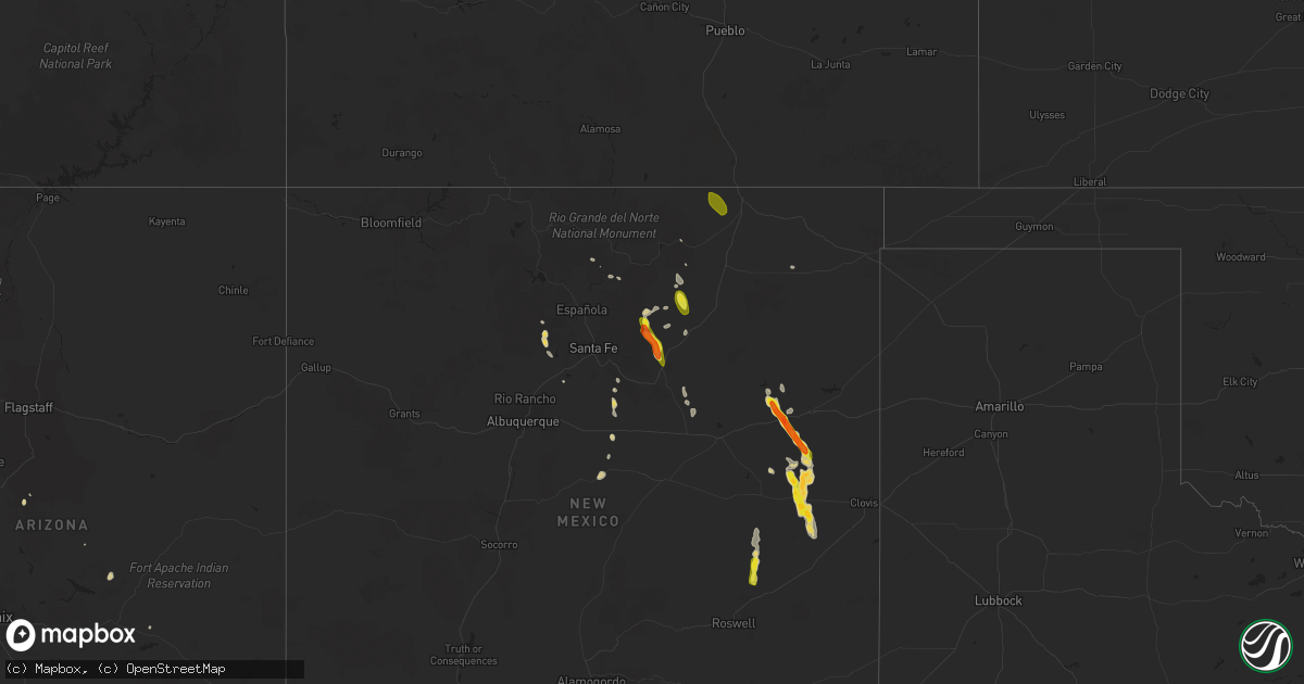
Hail Map on July 21, 2023
Get this storm
July 21 map
$229
one time, instant access
Download today. No call, no setup
Keep the $229
Bought the map and want the full workflow? Apply the entire $229 to a subscription within 7 days. None of it is wasted.
Every map, not just this one
This buys you this map. Subscription and you get every map we run, in the markets you choose from a few cities to whole states to nationwide. Plus real-time alerts the moment a storm fires.
Contact data
Name, contact info, occupancy, even credit band for addresses in the footprint. You go from where it hit to who to call.
Become the source they trust
Unlimited branding weather history reports on demand. You already have the documented answer ready for the property owner, and you are the one who showed up with it.
Property data and RoofTrace estimates
Pull up any address you have got, its value and the exact code rules for that jurisdiction, straight from One Click Code. Then RoofTrace estimates the squares, pitch, and roof value, priced the way you price.
States Impacted by Hail Map on July 21, 2023
Storm reports
Florida
| Date | Description |
|---|---|
| 07/21/20233:00 PM CDT | Wind damage was reported to fences and temporary tents. Time estimated from radar. |
South Dakota
| Date | Description |
|---|---|
| 07/21/20236:45 PM CDT | A tremendous amount of nickel hail which shredded bean and corn leaves. A few stones as large as a quarter. |
| 07/21/20235:31 PM CDT | A local report indicates 1.75 inch wind near 8 ESE Hermosa |
| 07/20/20238:05 PM CDT | Lasted about a minute. |
Colorado
| Date | Description |
|---|---|
| 07/21/202310:45 AM CDT | Delayed report. |
| 07/20/202311:07 PM CDT | A local report indicates 1.25 inch wind near 3 WSW Black Forest |
| 07/20/202310:52 PM CDT | A local report indicates 1.00 inch wind near 4 ESE Monument |
| 07/20/20239:24 PM CDT | Mesonet station co221 aurora i-70/airport blvd. |
| 07/20/20238:54 PM CDT | A local report indicates 1.00 inch wind near 3 W Gill |
| 07/20/20238:52 PM CDT | Report from mping: ping pong ball |
| 07/20/20237:22 PM CDT | A local report indicates 1.00 inch wind near New Raymer |
Nebraska
| Date | Description |
|---|---|
| 07/20/20239:17 PM CDT | A local report indicates 1.00 inch wind near 10 NNW Brewster |
Arizona
| Date | Description |
|---|---|
| 07/21/20236:34 PM CDT | Asos station ksad safford regional airport. |
| 07/21/20236:20 PM CDT | Mesonet station qgta3 guthrie. |
New Hampshire
| Date | Description |
|---|---|
| 07/21/20233:56 PM CDT | Delayed report...hail fell in vicinity of nashua airport for 7-8 minutes. Estimated at quarter size. |
| 07/21/20233:50 PM CDT | Delayed report...a few trees down on pine hill rd. |
| 07/21/20233:46 PM CDT | Delayed report...trained spotter observed downed trees and larges branches around greeley park and other parts of north nashua. |
| 07/21/20233:46 PM CDT | A local report indicates 1.25 inch wind near 1 W Hollis |
| 07/21/20233:40 PM CDT | Trees down on lake potanipo and nh hwy 130 in brookline with diameters of 7-10 inches. Small hail also reported. |
| 07/21/20233:32 PM CDT | Delayed report...uprooted tree partially blocking wheeler rd near apple tree farm. |
Alabama
| Date | Description |
|---|---|
| 07/21/20236:34 PM CDT | A few trees were blown down around gaylesville. |
| 07/21/20236:32 PM CDT | A few trees were blown down around centre. |
| 07/21/20236:32 PM CDT | A tree was blown down on woodmont road and landed on a home. |
| 07/21/20236:24 PM CDT | A few trees were blown down around sand rock. |
| 07/21/20236:20 PM CDT | Large tree uprooted along old tuscaloosa highway in mccalla. |
| 07/21/20236:20 PM CDT | Large tree uprooted at alford avenue and ivey lane. |
| 07/21/20236:20 PM CDT | Tree uprooted at 717 shades crest road. |
| 07/21/20235:58 PM CDT | Damage to exxon canopy in hampton cove. |
| 07/21/20235:43 PM CDT | Power lines down on ham road. |
| 07/21/20235:43 PM CDT | A few trees were blown down in weaver. |
| 07/21/20235:41 PM CDT | Trees down on wales road... Partially blocking the roadway. |
| 07/21/20235:40 PM CDT | A tree was uprooted and blocking the roadway on 55th st and glade road. |
| 07/21/20235:37 PM CDT | Tree down w/partial blockage on nuclear plant road... West of hatchett ridge in athens. |
| 07/21/20235:37 PM CDT | A few trees were blown down in the saks/lenlock area. |
| 07/21/20235:36 PM CDT | A tree was snapped and knocked power lines down into roadway. |
| 07/21/20235:33 PM CDT | Corrects previous tstm wnd dmg report from 4 nne owens crossroads. Several large branches were broken off of trees at this location. |
| 07/21/20235:33 PM CDT | Corrects previous tstm wnd dmg report from 4 nne owens crossroads. At this location 3 large trees were uprooted and fell in different directions. Two others were snappe |
| 07/21/20235:32 PM CDT | Corrects previous tstm wnd dmg report from 5 n owens crossroads. A large tree was blown across the entrance to the hampton cove waterfall near the golf course. |
| 07/21/20235:32 PM CDT | Corrects previous tstm wnd dmg report from 6 n owens crossroads. Several trees were either uprooted or broken off near their base. |
| 07/21/20235:28 PM CDT | Tree down county road 55 north of low gap. |
| 07/21/20235:28 PM CDT | Corrects previous tstm wnd dmg report from 6 nnw owens crossroads. Damage to exxon canopy in hampton cove. |
| 07/21/20235:28 PM CDT | Report from mping: 1-inch tree limbs broken; shingles blown off. |
| 07/21/20235:28 PM CDT | Corrects previous tstm wnd dmg report from 6 nnw owens crossroads. Sign to sonic was blown out at this location. |
| 07/21/20235:25 PM CDT | Corrects previous tstm wnd dmg report from 7 nnw owens crossroads. Large portion of a tree torn off on paul road. |
| 07/21/20235:22 PM CDT | Corrects previous tstm wnd dmg report from 6 nnw owens crossroads. Two large branches from a small oak tree torn off at this location. |
| 07/21/20235:21 PM CDT | Roof damage reported at the glencoe elementary school. |
| 07/21/20235:21 PM CDT | Roof damage reported at the glencoe middle school. |
| 07/21/20235:20 PM CDT | Corrects previous tstm wnd dmg report from 6 se huntsville. A large tree was uprooted and knocked down power lines at the intersection of weatherly road and valley view |
| 07/21/20235:19 PM CDT | Multiple trees and power lines reported down along strong drive se. |
| 07/21/20235:18 PM CDT | A few trees and power lines were blown down on highway 278. |
| 07/21/20235:14 PM CDT | Tree was blown down on rainbow drive. |
| 07/21/20235:12 PM CDT | A tree was blown over onto a home on berea ave. |
| 07/21/20235:12 PM CDT | A tree was blown down on grand ave. And landed on a vehicle. |
| 07/21/20235:10 PM CDT | Trees were blown down and blocking railroad tracks at popes chapel road. |
| 07/21/20235:10 PM CDT | Tree uprooted just west of natchez trace pkwy north of cloverdale... About 2 mi s of the tn state line. |
| 07/21/20235:04 PM CDT | A tree was blown down and blocking the roadway on 13th st nw. |
| 07/21/20235:04 PM CDT | Shingles off a home at brownsferry and lucas ferry roads in athens. |
| 07/21/20235:00 PM CDT | Roof partially torn off school and upstairs classrooms flooded. Athens renaissance middle school on clinton street. |
| 07/21/20234:58 PM CDT | Trees down partially blocking roadway on the 500 block of 7th avenue. |
| 07/21/20234:56 PM CDT | Trees and power lines were blown down on the 800 block of levert avenue. |
| 07/21/20234:52 PM CDT | Trees down near the intersection of elk river mills road and fort hampton road. |
| 07/21/20234:50 PM CDT | Multiple trees were blown down in the western half of the county. |
| 07/21/20234:33 PM CDT | At this location 3 large trees were uprooted and fell in different directions. Two others were snapped near the base near those uprooted trees. |
| 07/21/20234:33 PM CDT | Several large branches were broken off of trees at this location. |
| 07/21/20234:32 PM CDT | Several trees were either uprooted or broken off near their base. |
| 07/21/20234:32 PM CDT | Tree was blown down near reid road and spunky hollow road. |
| 07/21/20234:28 PM CDT | Sign to sonic was blown out at this location. |
| 07/21/20234:25 PM CDT | Large portion of a tree torn off on paul road. |
| 07/21/20234:24 PM CDT | Trees were blown down on twin oaks drive. |
| 07/21/20234:22 PM CDT | Two large branches from a small oak tree torn off at this location. |
| 07/21/20234:22 PM CDT | Trees and power lines were blown down near cr 51 and poultry drive. |
| 07/21/20234:21 PM CDT | Trees were blown down on cr 47. |
| 07/21/20234:20 PM CDT | Tree was blown down and blocking the roadway near ketchum road and bullard road. |
| 07/21/20234:20 PM CDT | A large tree was uprooted and knocked down power lines at the intersection of weatherly road and valley view drive se. |
| 07/21/20234:13 PM CDT | Multiple trees down. Some on vehicles. No injures reported. |
| 07/20/20237:42 PM CDT | A large tree was blown down at west blvd and birmingham hwy. |
| 07/20/20237:42 PM CDT | A very large tree was blown down and blocking macedonia road. |
| 07/20/20237:29 PM CDT | Reports of multiple trees down on red hill road in the kent community. |
| 07/20/20237:24 PM CDT | Reports of multiple trees blown down on castaway island road. |
Georgia
| Date | Description |
|---|---|
| 07/21/20236:50 PM CDT | Tree down at center st sw and daniel st in mableton. |
| 07/21/20236:50 PM CDT | Tree down at thornton rd and n blairs bridge rd. |
| 07/21/20236:45 PM CDT | Numerous trees and powerlines down in douglasville along hwy5 between nations dr and kings hwy. Two reports of trees on houses. |
| 07/21/20236:44 PM CDT | Multiple trees down near the intersection of highway 5 and amber dr. |
| 07/21/20236:42 PM CDT | Tree down at vulcan dr and groovers lake rd. |
| 07/21/20235:58 PM CDT | Corrects previous flash flood report from 1 w atlantic station. Cars stalled from high waters along huff rd nw. |
| 07/21/20235:41 PM CDT | Tree down near the intersection of booze mountain rd and pine st. |
| 07/21/20235:38 PM CDT | Tree reported down near the intersection of cave springs rd and summerwind dr. |
| 07/21/20235:29 PM CDT | Tree down at the intersection of briarcliff rd and old briarcliff rd. |
| 07/21/20235:26 PM CDT | Trees reported down near the intersection of veterans memorial hwy se and oakdale rd se. |
| 07/21/20235:26 PM CDT | A tree was reported down on a house near the intersection of burton dr ne and stephens dr ne. |
| 07/21/20235:25 PM CDT | Large oak tree down near the intersection of mentelle dr ne and 7th st ne. |
| 07/21/20235:09 PM CDT | Tree down across railroad tracks along whitney rd. |
| 07/21/20235:08 PM CDT | Tree down across the road near the intersection of buttermilk rd sw and henson rd sw. |
| 07/21/20235:05 PM CDT | A tree blown down near the intersection of montevideo rd and sandy lane dr. |
| 07/21/20234:36 PM CDT | Powerlines down near the intersection of panola rd and rock springs rd. |
| 07/21/20234:33 PM CDT | Report from mping: trees uprooted or snapped; roof blown off. |
| 07/21/20234:30 PM CDT | Tree was reported down on a powerline off brannon drive. |
| 07/20/202310:00 PM CDT | Tree limbs down with storms moving through the area. |
| 07/20/202310:00 PM CDT | From 911 call center reports of quite a few trees down across east and northeast portions of the county from. |
| 07/20/20239:53 PM CDT | Tree down on home on peachtree st. |
| 07/20/20239:48 PM CDT | Tree down near hwy45. |
| 07/20/20239:38 PM CDT | Multiple trees down along interstate 16 between mile markers 80 and 76. |
| 07/20/20239:35 PM CDT | Portion of metal roofing taken off of mobile home in alamo... Ga. Damage to vehicles from wooden roof debris. |
| 07/20/20239:30 PM CDT | Reports of tress down throughout the county... Especially across southern portions where storms rolled through. |
| 07/20/20239:10 PM CDT | Multiple large trees... Approximately 3 ft in diameter... Blown down. |
| 07/20/20238:27 PM CDT | Multiple trees reported down over and along hwy 221. |
| 07/20/20237:53 PM CDT | Numerous trees down at residence near vining rd and indian lake rd. |
Arkansas
| Date | Description |
|---|---|
| 07/21/20231:23 PM CDT | Powerlines down and power poles snapped around the high school area. |
| 07/21/202312:55 PM CDT | Multiple trees down across poinsett county. |
| 07/21/202312:53 PM CDT | Reported powerline down. |
| 07/21/202312:42 PM CDT | Corrects previous tstm wnd dmg report from widener. Reported powerline down. |
| 07/21/202311:24 AM CDT | Tree reported to be blown down and covering roadway. |
| 07/21/20239:16 AM CDT | Tree blown down onto some trucks at a landscaping company. |
| 07/21/20238:59 AM CDT | Social media report of broken tree branch in north ft. Smith. |
| 07/21/20238:58 AM CDT | Tree fell onto a house in sw little rock. |
| 07/21/20238:36 AM CDT | Report from mping: trees uprooted or snapped. |
| 07/21/20238:35 AM CDT | Social media report of thunderstorm wind damage. Pic of downed tree and broken tree branch. |
| 07/21/20237:55 AM CDT | Tree blown down and blocking portion of highway 9 south. |
Massachusetts
| Date | Description |
|---|---|
| 07/21/20236:50 PM CDT | In the area of south shelburne road - tree and wires down. Relayed by amateur radio. |
| 07/21/20235:35 PM CDT | Trees and wires down near hollis st. |
| 07/21/20235:34 PM CDT | Tree down blocking chicopee rd. |
| 07/21/20234:21 PM CDT | Multiple trees and wires downed on barker hill rd in townsend. Power lost but was restored at 755 pm. Time estimated by radar. |
| 07/21/20233:36 PM CDT | Tree down on wires on barker hill rd near turnpike rd. Relayed by amateur radio. |
| 07/20/202310:06 PM CDT | River road north of hillside - 2 trees down. |
| 07/20/20238:35 PM CDT | Trees and wires down on shore road. Relayed by amateur radio. |
| 07/20/20238:35 PM CDT | Tree down on ayers st. Relayed by amateur radio. |
| 07/20/20237:55 PM CDT | Tree down on winch st. Relayed by amateur radio. |
| 07/20/20237:25 PM CDT | In the area of sylvester road - tree down. |
| 07/20/20237:20 PM CDT | Corrects previous tstm wnd dmg report from deerfield. River road north of hillside - 2 trees down. |
Oklahoma
| Date | Description |
|---|---|
| 07/21/20237:05 AM CDT | Social media report of large tree downed onto power lines in salina. Relayed by broadcast media. Time estimated by radar. |
South Carolina
| Date | Description |
|---|---|
| 07/20/20239:00 PM CDT | Spotter called and reported a tree down on two power poles on golden jubilee rd near windy rd. Time estimated by radar. |
| 07/20/20237:35 PM CDT | Corrects previous tstm wnd gst report from 2 nne harbison state forest. 63 mph wind gust reported by rcwinds mesonet at richland county landfill at landfill road. Downb |
New Mexico
| Date | Description |
|---|---|
| 07/21/20236:35 PM CDT | Peak wind gust of 61 mph at nmdot surface observation site. Visibilities dropped to less than half a mile as well. |
| 07/21/20235:45 PM CDT | A local report indicates 1.25 inch wind near 5.1 WNW Sapello |
| 07/21/20235:37 PM CDT | A local report indicates 1.00 inch wind near 1 WSW Las Vegas |
Tennessee
| Date | Description |
|---|---|
| 07/21/20234:25 PM CDT | A tree was blown down onto a garage and two cars along beartown road. |
| 07/21/20234:25 PM CDT | A tree fell on power lines on 3rd street in lawrenceburg. |
| 07/21/20234:21 PM CDT | A tree was blown down across road near the intersection of s old military road and fairview road. |
| 07/21/20233:33 PM CDT | Trees down on a house with 4 occupants inside. Occupants un-injured. Time is radar estimated. |
| 07/21/20233:27 PM CDT | Nursing home in savannah is without power due to trees down and transformers are sparking on sterling lane. Time is radar estimated. |
| 07/21/20233:25 PM CDT | Trees down... A possible vehicle accident due to trees down... Power outages across hardin county. Time is radar estimated. |
| 07/21/20233:25 PM CDT | 60 mph wind gust measured on weather station. |
| 07/21/20233:20 PM CDT | Tree on house on woodland dr in henderson. Relayed by media. Time is radar estimated. |
| 07/21/20232:28 PM CDT | Tree on house on college st. In whiteville. Widespread trees and powerlines down across the county. |
| 07/21/20232:24 PM CDT | Tree on house in germantown. |
| 07/21/20232:16 PM CDT | Trees down across haywood county. |
| 07/21/20232:14 PM CDT | Tree down blocking both lanes across hwy 57 in the 11200 block... East of rossville. Time is radar estimated. |
| 07/21/20232:11 PM CDT | Powerline down on greenleaf cemetery road. |
| 07/21/20232:02 PM CDT | Tree down across mt. Carmel rd just north of waley lane. Time is radar estimated. |
| 07/21/20232:01 PM CDT | Power lines down in the 4300 block of marshall rd. Time is radar indicated. |
| 07/21/20232:00 PM CDT | Trees down. Time is radar estimated. |
| 07/21/20231:58 PM CDT | Measured wind gust. Snapped 3 inch flag pole. |
| 07/21/20231:55 PM CDT | Tree down on powerline on holmes road west of forest wind dr. |
| 07/21/20231:54 PM CDT | Corrects previous tstm wnd dmg report from 2 wnw germantown. Tree on house in germantown. |
| 07/21/20231:52 PM CDT | Numerous trees down across the southern half of tipton county. |
| 07/21/20231:43 PM CDT | Bartlett pd reports ivanhoe rd at kenwood cv impassable due to tree down. Time is radar estimated. |
| 07/21/20231:43 PM CDT | *** 1 inj *** corrects previous tstm wnd dmg report from 3 n southeast memphis. Tree fell on car on park avenue. Time is radar estimated. 1 injury. |
| 07/21/20231:43 PM CDT | Trees down across parts of austin peay - east of millington; along pleasant ridge & raleigh-millington road. Time is radar estimated. |
| 07/21/20231:40 PM CDT | Tree on two vehicles on allison ave in binghampton. Time is radar estimated. |
Mississippi
| Date | Description |
|---|---|
| 07/21/20234:47 PM CDT | Reported tree down on coontail rd. |
| 07/21/20234:45 PM CDT | Reported tree down along highway 278. |
| 07/21/20233:57 PM CDT | Large tree branches snapped in half near dulaney branch hill. |
| 07/21/20233:47 PM CDT | Multiple trees down throughout the county. |
| 07/21/20233:47 PM CDT | Roof damage to the dirt cheap in tupelo. Time is radar estimated. |
| 07/21/20233:46 PM CDT | Tree down on a house in the auburn community. |
| 07/21/20233:34 PM CDT | Corrects previous tstm wnd dmg report from saltillo. Relayed by broadcast media: tree snapped near a pool in saltillo... Ms. |
| 07/21/20233:09 PM CDT | Large tree snapped and fell on a home in new albany. |
| 07/21/20231:59 PM CDT | Tree down on hilliard rd. In cayce area. |
Connecticut
| Date | Description |
|---|---|
| 07/21/20236:17 PM CDT | Trees and wires down blocking road at ardmore and greenway st. |
| 07/21/20235:50 PM CDT | Tree down on kings highway. Relayed by amateur radio. |
| 07/21/20235:40 PM CDT | Corrects previous tstm wnd dmg report from chaplin. 2 cars crushed from 24 inch oak tree uprooted. Multiple roads closed in the area. |
| 07/21/20235:40 PM CDT | Multiple trees down in chaplin ct. |
| 07/21/20235:40 PM CDT | Tree down on plains rd. |
| 07/21/20235:30 PM CDT | 2 cars crushed from 24 inch oak tree uprooted. Multiple roads closed in the area. |
Vermont
| Date | Description |
|---|---|
| 07/21/20234:15 PM CDT | Tree down on route 66. Over 1200 power outages in the town |
| 07/21/20234:12 PM CDT | Public called and reported quarter size hail on porters point road in colchester... Time estimated by radar. |
| 07/21/20233:40 PM CDT | A tree uprooted and landed on a camper... One camper lost its entire front porch... Small hail |
| 07/21/20233:36 PM CDT | Tree down with power outages near lakewood drive and campgrounds |
| 07/21/20233:20 PM CDT | Uprooted tree in alburgh |
Iowa
| Date | Description |
|---|---|
| 07/20/20237:06 PM CDT | 3 to 4 inch diameter tree limbs down. |
Cities Impacted by Hail Map on July 21, 2023
- Roland, AR
- Bigelow, AR
- Ola, AR
- Fort Smith, AR
- Morrilton, AR
- Adona, AR
- Perryville, AR
- Houston, AR
- Perry, AR
- Charleston, AR
- Lavaca, AR
- Magazine, AR
- Southaven, MS
- Olive Branch, MS
- Horn Lake, MS
- Little Rock, AR
- Plainview, AR
- Bryant, AR
- Alexander, AR
- Benton, AR
- Mayflower, AR
- Paron, AR
- Earle, AR
- West Memphis, AR
- Drummonds, TN
- Bassett, AR
- Marion, AR
- Wilson, AR
- Millington, TN
- Frenchmans Bayou, AR
- Tyronza, AR
- Joiner, AR
- Memphis, TN
- Crawfordsville, AR
- Gilmore, AR
- Turrell, AR
- Munford, TN
- Covington, TN
- Brighton, TN
- Burlison, TN
- Atoka, TN
- Stanton, TN
- Brownsville, TN
- Mason, TN
- Arlington, TN
- Cordova, TN
- Williston, TN
- Somerville, TN
- Collierville, TN
- Eads, TN
- Rossville, TN
- Oakland, TN
- Germantown, TN
- Moscow, TN
- Proctor, AR
- Dyess, AR
- Medon, TN
- Pinson, TN
- Henderson, TN
- Grand Junction, TN
- Jackson, TN
- Bolivar, TN
- Denmark, TN
- Mercer, TN
- Toone, TN
- Whiteville, TN
- Hickory Valley, TN
- Bethel Springs, TN
- Michigan City, MS
- Pocahontas, TN
- Walnut, MS
- Hornsby, TN
- Finger, TN
- Falkner, MS
- Tiplersville, MS
- Saulsbury, TN
- Middleton, TN
- La Grange, TN
- Ashland, MS
- Selmer, TN
- Lamar, MS
- Holly Springs, MS
- Byhalia, MS
- Alburgh, VT
- Ramer, TN
- Adamsville, TN
- Corinth, MS
- Brookline, NH
- Hollis, NH
- Ocate, NM
- Guadalupita, NM
- Las Vegas, NM
- Mora, NM
- Rociada, NM
- Sapello, NM
- Montezuma, NM
- Rapid City, SD
- Hermosa, SD
- Pavillion, WY
- Red Banks, MS
- South Hero, VT
- Williamstown, MA
- Aberdeen, MS
- Amory, MS
- Leominster, MA
- West Townsend, MA
- Townsend, MA
- Hayden, AL
- Bremen, AL
- Hanceville, AL
- Wendell, MA
- Los Alamos, NM
- Shelburne Falls, MA
- South Deerfield, MA
- Williamsburg, MA
- Ashfield, MA
- Conway, MA
- Deerfield, MA
- Columbia, TN
- Stone Mountain, GA
- Decatur, GA
- Atkins, AR
- Atlanta, GA
- Fayetteville, TN
- Taft, TN
- Buffalo, WY
- Belfast, TN
- Petersburg, TN
- Enterprise, MS
- Hickory, MS
- Chatsworth, GA
- Park Valley, UT
- Snowville, UT
- Tupelo, MS
- Lunenburg, MA
- Fitchburg, MA
- Westminster, MA
- Ashby, MA
- Lilburn, GA
- Snellville, GA
- Cimarron, NM
- Princeton, MA
- Pepperell, MA
- Chaplin, CT
- Mansfield Center, CT
- Storrs Mansfield, CT
- Montague, MA
- Zolfo Springs, FL
- Erving, MA
- Okolona, MS
- Vinemont, AL
- Addison, AL
- Danville, AL
- Fort Lauderdale, FL
- Walls, MS
- Cullman, AL
- Grant, AL
- Woodville, AL
- Sylacauga, AL
- Weogufka, AL
- Pontotoc, MS
- Calhoun, GA
- Armuchee, GA
- Downey, ID
- Champlain, NY
- Indianola, MS
- Rising Fawn, GA
- Shirley, MA
- Dunstable, MA
- Ashburnham, MA
- Hubbardston, MA
- Groton, MA
- Venus, FL
- Moore Haven, FL
- Crump, TN
- Savannah, TN
- Shelbyville, TN
- Lewisburg, TN
- Belden, MS
- Hohenwald, TN
- Volin, SD
- Mission Hill, SD
- Gayville, SD
- Whitewood, SD
- Sturgis, SD
- Deadwood, SD
- New Raymer, CO
- Stoneham, CO
- Merino, CO
- Raton, NM
- Conchas Dam, NM
- Tucumcari, NM
- Greeley, CO
- Kersey, CO
- Gill, CO
- Mcalister, NM
- Wellington, CO
- Cheyenne, WY
- Carr, CO
- Nunn, CO
- Johnstown, NE
- Ainsworth, NE
- Brewster, NE
- Purdum, NE
- Melrose, NM
- Floyd, NM
- Grover, CO
- Ault, CO
- Lander, WY
- Dunning, NE
- Cleveland, NM
- Sunderland, MA
- Irene, SD
- Fairburn, SD
- North Franklin, CT
- Willimantic, CT
- Windham, CT
- Lebanon, CT
- South Windham, CT
- Tyngsboro, MA
- Westford, MA
- Brookwood, AL
- McCalla, AL
- Bessemer, AL
- Bairoil, WY
- Wamsutter, WY
- Moriarty, NM
- Ware, MA
- Colchester, VT
- Burlington, VT
- Balaton, MN
- Perry, GA
- Fort Valley, GA
- Vienna, GA
- Preston, ID
- Briggsdale, CO
- East Dublin, GA
- Rockmart, GA
- Cedartown, GA
- Arabi, GA
- Berry, AL
- Easthampton, MA
- Flandreau, SD
- Elkton, SD
- Aiken, SC
- Pleasant Grove, AL
- Birmingham, AL
- Fairfield, AL
- Mulga, AL
- Dolomite, AL
- Mount Pleasant, TN
- House, NM
- Stanley, NM
- McCool, MS
- Gray Court, SC
- Enoree, SC
- Ponderosa, NM
- Snyder, CO
- Marshallville, GA
- Reynolds, GA
- Union, SC
- Dudley, GA
- Montrose, GA
- Dublin, GA
- Southampton, MA
- Holyoke, MA
- South Hadley, MA
- Florence, MA
- Watrous, NM
- Pine Hill, AL
- Thomasville, AL
- Centreville, AL
- Brierfield, AL
- Penasco, NM
- Kathleen, GA
- Crawford, MS
- Starkville, MS
- Auburn, AL
- Pinson, AL
- Morris, AL
- Sawyerville, AL
- Waverly, AL
- Camp Hill, AL
- Thomaston, AL
- Arlington, AL
- Gordo, AL
- Granite Canon, WY
- Arcadia, FL
- Pipestone, MN
- Lowell, MA
- Hadley, MA
- Northampton, MA
- Hatfield, MA
- West Hatfield, MA
- Plainville, GA
- La Salle, CO
- Hampton, CT
- Warrior, AL
- Valentine, NE
- Mission, SD
- Nashua, NH
- Linden, AL
- Magnolia, AL
- West Point, GA
- Hamilton, GA
- Clanton, AL
- Rutland, MA
- Evans, CO
- Adams, MA
- Pauline, SC
- Buffalo, SC
- Dry Branch, GA
- Bonaire, GA
- Trafford, AL
- Kimberly, AL
- Lamy, NM
- Elgin, AZ
- Wood Lake, NE
- Guilford, CT
- Oakman, AL
- Pena Blanca, NM
- Cochiti Pueblo, NM
- Equality, AL
- Alexander City, AL
- Dadeville, AL
- Thorndike, MA
- Belchertown, MA
- Palmer, MA
- Bondsville, MA
- Moorhead, MS
- Inverness, MS
- Marietta, GA
- Weir, MS
- Sparks, NE
- Adger, AL
- Hope Hull, AL
- Montgomery, AL
- Young, AZ
- Ohatchee, AL
- Ragland, AL
- Piedmont, AL
- Gadsden, AL
- Alexandria, AL
- Anniston, AL
- Summerville, GA
- Ridgeville, SC
- Cusseta, GA
- Tennille, GA
- Madison, GA
- Orrville, AL
- Safford, AL
- Scenic, SD
- Keystone, SD
- North Haven, CT
- East Haven, CT
- Branford, CT
- Hamden, CT
- New Haven, CT
- North Branford, CT
- Woodbridge, CT
- Northford, CT
- Catherine, AL
- Granby, MA
- Ludlow, MA
- Three Rivers, MA
- New Salem, MA
- Alamo, GA
- Tombstone, AZ
- Higdon, AL
- Flat Rock, AL
- Trenton, GA
- Douglas, AZ
- Devens, MA
- Ayer, MA
- Wetumpka, AL
- Tallassee, AL
- Eclectic, AL
- Box Springs, GA
- Jemison, AL
- Northport, AL
- Camden, AL
- Florissant, CO
- Glenwood, GA
- Carrollton, AL
- Altoona, AL
- Gardner, MA
- Acton, MA
- Littleton, MA
- Boxborough, MA
- Harvard, MA
- Lancaster, MA
- Trussville, AL
- Gardendale, AL
- Pennington, AL
- Musella, GA
- Jacksonville, GA
- Viborg, SD
- Salem, SD
- Tuscaloosa, AL
- Ellerslie, GA
- Midland, GA
- Cataula, GA
- Upatoi, GA
- Rockledge, GA
- Cambridge, MA
- Somerville, MA
- Boston, MA
- Charlestown, MA
- East Boston, MA
- Everett, MA
- Chelsea, MA
- Roswell, NM
- North Brookfield, MA
- Callaway, NE
- Monument, CO
- Fitzgerald, GA
- Rebecca, GA
- Ocilla, GA
- Colorado Springs, CO
- Franktown, CO
- Larkspur, CO
- Lynn, MA
- Revere, MA
- Saugus, MA
- Nahant, MA
- Abbeville, AL
- Adrian, GA
- Guffey, CO
- Elbert, CO
- Arlington, GA
- Encino, NM
- Blakely, GA
- Fort Gaines, GA
- Bluffton, GA
- Coleman, GA
- Ashburn, GA
- Fort Sumner, NM
- Leesburg, GA
- Holliston, MA
- Cross, SC
- Arnold, NE
- Hartsel, CO
- Pinopolis, SC
- South Boston, MA
- Hull, MA
- Orchard, CO
- Matheson, CO
- Cripple Creek, CO
- Denton, GA
- Hazlehurst, GA
- Cordele, GA
- Columbia, AL
- Brookline, MA
- Swampscott, MA
- Malden, MA
- Roxbury Crossing, MA
- Winthrop, MA
- West Brookfield, MA
- Warren, MA
- Mount Vernon, GA
- Norway, SC
- Anselmo, NE
- Clarkston, GA
- Scottdale, GA
- Elida, NM
- Albany, GA
- Newton, GA
- Shorterville, AL
- Rochelle, GA
- Pine Apple, AL
- Sylvester, GA
- Cuthbert, GA
- Red Level, AL
- Rainsville, NM
- Weston, GA
- Richland, GA
- Plantersville, AL
- Selma, AL
- Lumpkin, GA
- Dixons Mills, AL
- Castle Rock, CO