Hail Map in South Dakota on July 20, 2013
Get this storm
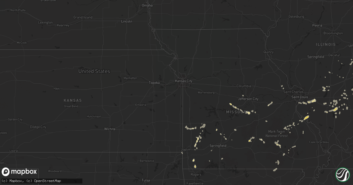
July 20 map
$229
one time, instant access
Download today. No call, no setup
Keep the $229
Bought the map and want the full workflow? Apply the entire $229 to a subscription within 7 days. None of it is wasted.
Every map, not just this one
This buys you this map. Subscription and you get every map we run, in the markets you choose from a few cities to whole states to nationwide. Plus real-time alerts the moment a storm fires.
Contact data
Name, contact info, occupancy, even credit band for addresses in the footprint. You go from where it hit to who to call.
Become the source they trust
Unlimited branding weather history reports on demand. You already have the documented answer ready for the property owner, and you are the one who showed up with it.
Property data and RoofTrace estimates
Pull up any address you have got, its value and the exact code rules for that jurisdiction, straight from One Click Code. Then RoofTrace estimates the squares, pitch, and roof value, priced the way you price.
Storm reports in South Dakota
South Dakota
| Date | Description |
|---|---|
| 07/20/20136:38 PM CDT | A local report indicates 2.00 inch wind near 18 NW UNION CENTER |
| 07/20/20136:35 PM CDT | A local report indicates 1.75 inch wind near 7 SE PRAIRIE CITY |
| 07/20/20136:30 PM CDT | A local report indicates 60 MPH wind near 1 SE ENNING |
| 07/20/20136:30 PM CDT | A local report indicates 1.00 inch wind near 5 SE ENNING |
| 07/20/20136:00 PM CDT | A local report indicates 1.00 inch wind near 1 S DOWNTOWN BELLE FOUR |
| 07/20/20135:50 PM CDT | A local report indicates 1.00 inch wind near 7 S HARDING |
| 07/20/20135:40 PM CDT | A local report indicates 1.00 inch wind near 4 NE DOWNTOWN CUSTER |
| 07/20/20135:20 PM CDT | A local report indicates 1.00 inch wind near 7 NNE HOOVER |
| 07/20/20135:15 PM CDT | A local report indicates 1.25 inch wind near 15 SSW REVA |
| 07/20/20135:10 PM CDT | A local report indicates 1.00 inch wind near 4 NE DOWNTOWN CUSTER |
| 07/20/20135:05 PM CDT | A local report indicates 60 MPH wind near 16 SW REVA |
| 07/20/20135:00 PM CDT | A local report indicates 1.00 inch wind near BOX ELDER |
| 07/20/20134:51 PM CDT | A local report indicates 1.75 inch wind near 1 E DOWNTOWN RAPID CITY |
| 07/20/20134:47 PM CDT | A local report indicates 1.50 inch wind near 2 SW DOWNTOWN RAPID CIT |
| 07/20/20134:45 PM CDT | Cracked window at residence. |
| 07/20/20134:45 PM CDT | A local report indicates 2.00 inch wind near 2 NW DOWNTOWN RAPID CIT |
| 07/20/20134:45 PM CDT | A local report indicates 2.00 inch wind near 3 W DOWNTOWN RAPID CITY |
| 07/20/20134:45 PM CDT | At least 1.5 inch size hail on ground at canyon lake park |
| 07/20/20134:44 PM CDT | A local report indicates 1.00 inch wind near 4 WSW DOWNTOWN RAPID CI |
| 07/20/20134:43 PM CDT | A local report indicates 1.00 inch wind near 1 E DOWNTOWN RAPID CITY |
| 07/20/20134:43 PM CDT | A local report indicates 1.25 inch wind near 2 SW DOWNTOWN RAPID CIT |
| 07/20/20134:31 PM CDT | A local report indicates 1.75 inch wind near HISEGA |
| 07/20/20134:26 PM CDT | Lasted 326 pm to 336 pm |
| 07/20/20134:20 PM CDT | A local report indicates 1.00 inch wind near 1 N HISEGA |
| 07/20/20133:30 PM CDT | A local report indicates 1.00 inch wind near 8 W FAIRBURN |
| 07/20/20133:30 PM CDT | A local report indicates 1.00 inch wind near 13 SE DOWNTOWN CUSTER |
| 07/20/20133:11 PM CDT | A local report indicates 1.00 inch wind near 7 SW DOWNTOWN RAPID CIT |
| 07/20/20132:34 PM CDT | A local report indicates 1.00 inch wind near HILL CITY |
| 07/20/20132:35 AM CDT | A local report indicates 1.00 inch wind near 5 NE BATESLAND |
| 07/19/201310:30 PM CDT | A local report indicates 61 MPH wind near CHAMBERLAIN |
| 07/19/201310:20 PM CDT | A local report indicates 67 MPH wind near 2 W OACOMA |
| 07/19/201310:10 PM CDT | A local report indicates 66 MPH wind near 3 SE RELIANCE |
| 07/19/20139:10 PM CDT | A local report indicates 61 MPH wind near 14 N VIVIAN |
| 07/19/20139:06 PM CDT | Small tree downed. |
| 07/19/20138:15 PM CDT | A local report indicates 1.00 inch wind near 1 N CASTLE ROCK |
| 07/19/20137:55 PM CDT | A local report indicates 1.00 inch wind near 5 ESE ELM SPRINGS |
| 07/19/20137:15 PM CDT | A local report indicates 1.00 inch wind near 12 N WALL |
| 07/19/20137:15 PM CDT | A local report indicates 60 MPH wind near 8 SSW UNION CENTER |
| 07/19/20137:15 PM CDT | Most of the hail was pea size with some quarters mixed in and lasted 10-15 minutes |
| 07/19/20137:10 PM CDT | A local report indicates 1.75 inch wind near UNION CENTER |
All States Impacted by Hail Map on July 20, 2013
Cities Impacted by Hail Map on July 20, 2013
- Keenesburg, CO
- Mullen, NE
- Henderson, NV
- Las Vegas, NV
- Calico Rock, AR
- Pineville, AR
- Rapid City, SD
- Circle, MT
- Vida, MT
- Bolivar, MO
- Clarksburg, MD
- Germantown, MD
- Boyds, MD
- Chino Valley, AZ
- Merriman, NE
- Whitman, NE
- Valentine, NE
- Agate, CO
- Garnett, KS
- Briggsdale, CO
- Grover, CO
- Fort Morgan, CO
- Weldona, CO
- Roggen, CO
- Wiggins, CO
- Union Center, SD
- Rio Verde, AZ
- Bennett, CO
- Harrison, NE
- Strasburg, CO
- Fort Pierre, SD
- Draper, SD
- Belle Fourche, SD
- Black Hawk, SD
- Harriet, AR
- Marshall, AR
- Stockton, MO
- Buffalo Gap, SD
- Robinson, IL
- Hutsonville, IL
- Palestine, IL
- Prairie City, SD
- Reva, SD
- Bison, SD
- Kiowa, CO
- Elizabeth, CO
- Brighton, CO
- Denver, CO
- Broomfield, CO
- Mechanicsburg, OH
- South Vienna, OH
- London, OH
- El Dorado Springs, MO
- Hay Springs, NE
- Byers, CO
- Elbert, CO
- Bartlett, KS
- Keystone, SD
- Buffalo, SD
- Wideman, AR
- Oxford, AR
- New Lebanon, OH
- West Alexandria, OH
- Farmersville, OH
- Sutherlin, VA
- Tampa, FL
- Wesley Chapel, FL
- Cabool, MO
- Bucyrus, MO
- Vincentown, NJ
- Modoc, IL
- Ellis Grove, IL
- Sainte Genevieve, MO
- Evansville, IL
- Wickenburg, AZ
- Louisville, IL
- Xenia, IL
- East Bridgewater, MA
- Hanson, MA
- Whitman, MA
- Rockland, MA
- Wasta, SD
- New Underwood, SD
- Enning, SD
- Peerless, MT
- Bloomfield, MT
- Glendive, MT
- Ismay, MT
- Lindsay, MT
- Richey, MT
- Wolf Point, MT
- Fallon, MT
- Neodesha, KS
- Sims, IL
- Ridgeville, IN
- Union City, IN
- Portland, IN
- Blue Mound, KS
- Porcupine, SD
- Stephan, SD
- Highmore, SD
- Gaithersburg, MD
- Montgomery Village, MD
- Barnesville, MD
- Kingman, AZ
- Chestertown, MD
- Pratt, KS
- Gordon, NE
- Lawrence, NE
- Guide Rock, NE
- Deer Trail, CO
- Dugger, IN
- Carlisle, IN
- Linton, IN
- Jasonville, IN
- Washburn, MO
- Powell, MO
- Seligman, MO
- Pineville, MO
- Beallsville, MD
- Dickerson, MD
- Dalton City, IL
- Baker, CA
- Union, IL
- Gilberts, IL
- Hampshire, IL
- Huntley, IL
- Marengo, IL
- Hudson, CO
- Ironton, MO
- Bismarck, MO
- Mammoth Spring, AR
- Hardy, AR
- Middletown, DE
- Chesapeake City, MD
- Eldon, MO
- Laramie, WY
- Bosler, WY
- Newell, SD
- White Owl, SD
- Howes, SD
- Wall, SD
- Congress, AZ
- Faber, VA
- Shipman, VA
- Schuyler, VA
- Parker, KS
- Shumway, IL
- Ravenden, AR
- Williford, AR
- Ravenden Springs, AR
- Lockwood, MO
- Golden City, MO
- Hernandez, NM
- Abiquiu, NM
- Quapaw, OK
- Miami, OK
- Lebanon, MO
- Billings, MO
- Sylvan Grove, KS
- Lincoln, KS
- Littlefield, AZ
- Huggins, MO
- Mount Vernon, IL
- Waltonville, IL
- Opdyke, IL
- Du Bois, IL
- Tamaroa, IL
- Pinckneyville, IL
- Belle Rive, IL
- Smith Center, KS
- Whitney, NE
- Wood, SD
- Avon, IN
- Indianapolis, IN
- Plainfield, IN
- Fairbanks, IN
- Merom, IN
- Sullivan, IN
- Worton, MD
- Aurora, CO
- Egg Harbor City, NJ
- Union City, OH
- Ansonia, OH
- Rossburg, OH
- Custer, SD
- Kilgore, NE
- Calhan, CO
- Milo, MO
- Sheldon, MO
- Freeburg, IL
- Belleville, IL
- Silva, MO
- Patterson, MO
- Greenville, MO
- Welch, OK
- Hiawatha, KS
- Pukwana, SD
- Chamberlain, SD
- Quenemo, KS
- Batesland, SD
- Sullivan, IL
- Nellysford, VA
- Harrold, SD
- Pocahontas, AR
- Warm Springs, AR
- Oral, SD
- Fairburn, SD
- Martin, SD
- Grandin, MO
- Ellsinore, MO
- Moundville, MO
- Vandalia, IL
- Onida, SD
- Pomona, KS
- Waxahachie, TX
- Brigantine, NJ
- Lower Brule, SD
- Mulberry Grove, IL
- Cheyenne, WY
- Danville, PA
- Bloomsburg, PA
- Steelville, MO
- Shelburn, IN
- Centerville, KS
- Rushville, NE
- Watkins, CO
- Frazer, MT
- Toronto, KS
- Lewis, IN
- Clay City, IN
- Elk City, KS
- Hawk Springs, WY
- Radnor, OH
- Richwood, OH
- Saint Onge, SD
- Spearfish, SD
- Wellington, KS
- North Las Vegas, NV
- Midland, OH
- Baltimore, MD
- Dundas, IL
- Hill City, SD
- Gothenburg, NE
- Algonquin, IL
- Lake In The Hills, IL
- Crystal Lake, IL
- Vinita, OK
- Meta, MO
- Iberia, MO
- Dixon, MO
- Saint Elizabeth, MO
- San Manuel, AZ
- La Rue, OH
- Oxford, KS
- Agar, SD
- Marshall, IL
- Rosamond, IL
- Pana, IL
- Ramah, CO
- Belvidere, SD
- Rocky Comfort, MO
- Tucson, AZ
- Presho, SD
- Box Elder, SD
- Hartshorn, MO
- Reeds, MO
- Carthage, MO
- Avilla, MO
- Lebanon, KS
- Middle Brook, MO
- Douglas, WY
- Park Hills, MO
- Tuscumbia, MO
- Esmont, VA
- Charlottesville, VA
- Wilmington, OH
- Melbourne, AR
- Millstadt, IL
- Smithton, IL
- Cody, NE
- Prescott, AZ
- Rutherfordton, NC
- Stoy, IL
- Oblong, IL
- Willow Hill, IL
- Sumner, IL
- Claremont, IL
- Flat Rock, IL
- Geuda Springs, KS
- Oacoma, SD
- Houston, MO
- Licking, MO
- Ellington, MO
- Greenville, OH
- Bloomsdale, MO
- Bassett, NE
- Long Pine, NE
- Lusk, WY
- Manville, WY
- Parker, CO
- La Place, LA
- Bartlesville, OK
- Pawhuska, OK
- South Elgin, IL
- Elgin, IL
- Saint Charles, IL
- Peyton, CO
- Kirkland, AZ
- Red Bud, IL
- Larslan, MT
- Nashua, MT
- Martinsville, IN
- Springview, NE
- Mound City, KS
- Nemo, SD
- Gettysburg, SD
- Eagle Butte, SD
- Hereford, CO
- Alma, KS
- Arcola, MO
- Drake, CO
- Glen Haven, CO
- Virgil, KS
- Olney, IL
- Ashley, IL
- Bonnie, IL
- Scheller, IL
- Keyesport, IL
- Smithboro, IL
- Greenville, IL
- Success, MO
- Barnett, MO
- Versailles, MO
- Brinktown, MO
- Rosebud, MO
- Owensville, MO
- North East, MD
- Brady, NE
- Paxton, NE
- Arthur, NE
- Polk, MO
- Kennebec, SD
- Wentzville, MO
- Moscow Mills, MO
- Osborne, KS
- Concord, VA
- Appomattox, VA
- West Liberty, IL
- Sainte Marie, IL
- Newton, IL
- Liberty, IN
- Atkinson, NE
- Stuart, NE
- Black, MO
- Mount Victory, OH
- Blue Hill, NE
- Superior, NE
- Nelson, NE
- Columbus, NC
- Wingina, VA
- Lovingston, VA
- Globe, AZ
- Brooksville, FL
- Bluford, IL
- Pine Ridge, SD
- Forsyth, MO
- Cook Sta, MO
- Stapleton, NE
- Lake Lure, NC
- Ellicott City, MD
- Catonsville, MD
- New Baden, IL
- Mascoutah, IL
- Blunt, SD
- Tuckerton, NJ
- Hammonton, NJ
- Woodlawn, IL
- Gerald, MO
- Marion, NC
- North Garden, VA
- Fort Scott, KS
- Cedar Vale, KS
- Raritan, NJ
- Bridgewater, NJ
- Cowden, IL
- Buffalo, KS
- Yates Center, KS
- Crown King, AZ
- Hoyleton, IL
- Garrett, WY
- Mill Spring, MO
- Marietta, GA
- Morgantown, IN
- Edna, KS
- Walnut Hill, IL
- Centralia, IL
- Crawford, NE
- Noble, IL
- Lucas, KS
- Mud Butte, SD
- Ainsworth, NE
- Swoope, VA
- Sarcoxie, MO
- La Russell, MO
- Nashville, IL
- Homer, IL
- Coal City, IN
- Collins, MO
- Beloit, KS
- Wayne, IL
- Aguila, AZ
- Long Valley, SD
- Florissant, CO
- Saint Paul, KS
- Erie, KS
- Elkland, MO
- Saint Francis, SD
- Crookston, NE
- Scottsdale, AZ
- Fredonia, KS
- Orchard, CO
- Elburn, IL
- Aurora, MO
- Stella, MO
- Centertown, MO
- Jefferson City, MO
- Hartsburg, MO
- Freedom, IN
- Caldwell, KS
- Camden, OH
- Somerville, OH
- Doniphan, MO
- Belleview, MO
- Caledonia, MO
- Eskridge, KS
- Paxico, KS
- Manhattan, KS
- Pomfret Center, CT
- Keenes, IL
- Wayne City, IL
- Dahlgren, IL
- Atlantic City, NJ
- Merino, CO
- Indian Springs, NV
- Staten Island, NY
- Peru, KS
- Warsaw, VA
- La Cygne, KS
- Vivian, SD
- Dobson, NC
- Boonville, NC
- Jonesville, NC
- Pueblo, CO
- Pea Ridge, AR
- Bella Vista, AR
- Bentonville, AR
- Colorado Springs, CO
- Lyman, NE
- Searchlight, NV
- Coffeyville, KS
- Harmony, NC
- Statesville, NC
- Beecher City, IL
- Toledo, IL
- Gosport, IN
- Ellettsville, IN
- Flora, IL
- Marshfield, MO
- Guilford, CT
- Durham, CT
- Northford, CT
- Jackson, TN
- Keene, VA
- Scottsville, VA
- Covesville, VA
- Trenton, IL
- Doe Run, MO
- Galena, KS
- Seneca, MO
- Midland, SD
- Overton, NV
- Earleville, MD
- Brookeville, MD
- Derwood, MD
- Rinard, IL
- Spencer, IN
- Worthington, IN
- Sparta, IL
- Marissa, IL
- Charleston, IL
- Ash Fork, AZ
- Osteen, FL
- Oak Hill, FL
- Dundee, IL
- Hoffman Estates, IL
- Ina, IL
- Columbia, IL
- Woodstock, IL
- Iuka, IL
- Bonne Terre, MO
- Farmington, MO
- Lagrange, WY
- Allen, KS
- Edgemont, AR
- Wimauma, FL
- Parrish, FL
- Germantown, IL
- Killingworth, CT
- Covington, IN
- Bloomington, IN
- Tecopa, CA
- New Haven, MO
- Williamsville, MO
- Unionville, IN
- New Vienna, OH
- Leesburg, OH
- Sabina, OH
- San Ygnacio, TX
- Troy, MO
- Castalian Springs, TN
- Bushnell, FL
- Rocky Mount, MO
- Longton, KS
- Urbana, OH
- Arcadia, MO
- Arcola, IL
- Sedan, KS
- Chautauqua, KS
- Montello, WI
- Nokomis, IL
- Humboldt, IL
- Vienna, MO
- Bronaugh, MO
- Barnard, KS
- Ordway, CO
- Olney Springs, CO
- Greenfield, MO
- Sloan, NV
- Lenzburg, IL
- Hamill, SD
- Ringgold, VA
- Minneapolis, KS
- Mayer, AZ
- Saint Joe, AR
- Irondale, MO
- Landrum, SC
- Ashmore, IL
- Oakland, IL
- Buffalo, MO
- Half Way, MO
- Chatsworth, NJ
- Whittington, IL
- Benton, IL
- Gatewood, MO
- Couch, MO
- Spring, TX
- Allen, SD
- Springfield, OH
- Terre Haute, IN
- Barnhill, IL
- Fairfield, IL
- Walkersville, WV
- Horner, WV
- West Terre Haute, IN
- Dennison, IL
- Clay Center, KS
- Sahuarita, AZ
- Chetopa, KS
- Cloverdale, IN
- Quincy, IN
- Farmersburg, IN
- Pimento, IN
- Morganton, NC
- Ridgeway, OH
- West Mansfield, OH
- Niangua, MO
- Afton, VA
- Blanchester, OH
- Reliance, SD
- Dix, IL
- Texico, IL
- Kell, IL
- Middletown, OH
- Germantown, OH
- Albin, WY
- West Salem, IL
- Brooklyn, CT
- Lamar, MO
- Eminence, MO
- Ingraham, IL
- Mount Erie, IL
- Oconee, IL
- Altoona, KS
- Alton, MO
- Mapleton, KS
- Patton, MO
- Perryville, MO
- Salem, MO
- Raymondville, MO
- Belle Center, OH
- Rushsylvania, OH
- Kyle, SD
- Guffey, CO
- Havana, KS
- Mims, FL
- Ellsworth Afb, SD
- Carpenter, WY


