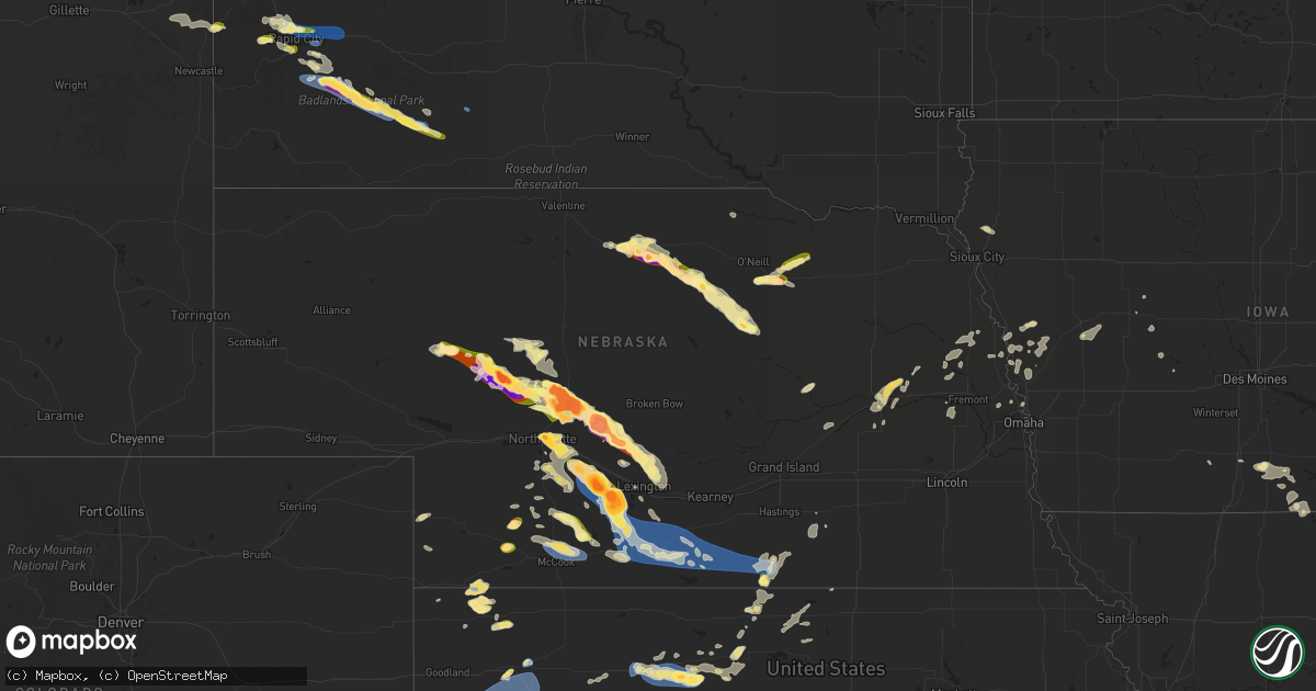
Hail Map in Nebraska on July 19, 2025
Get this storm
July 19 map
$229
one time, instant access
Download today. No call, no setup
Keep the $229
Bought the map and want the full workflow? Apply the entire $229 to a subscription within 7 days. None of it is wasted.
Every map, not just this one
This buys you this map. Subscription and you get every map we run, in the markets you choose from a few cities to whole states to nationwide. Plus real-time alerts the moment a storm fires.
Contact data
Name, contact info, occupancy, even credit band for addresses in the footprint. You go from where it hit to who to call.
Become the source they trust
Unlimited branding weather history reports on demand. You already have the documented answer ready for the property owner, and you are the one who showed up with it.
Property data and RoofTrace estimates
Pull up any address you have got, its value and the exact code rules for that jurisdiction, straight from One Click Code. Then RoofTrace estimates the squares, pitch, and roof value, priced the way you price.
Storm reports in Nebraska
Nebraska
| Date | Description |
|---|---|
| 07/19/20256:57 PM CDT | Report from mping: hen egg |
| 07/19/20256:55 PM CDT | Had large hail between 650 to 7pm ct with heavy rainfall. (lb |
| 07/19/20256:55 PM CDT | Had large hail between 650 to 7pm ct with heavy rainfall. |
| 07/19/20256:55 PM CDT | Time estimated by radar. |
| 07/19/20256:52 PM CDT | A local report indicates 1.75 inch wind near Eustis |
| 07/19/20256:41 PM CDT | Report from mping: quarter |
| 07/19/20256:40 PM CDT | Spotter network reports baseball sized hail northeast of farnam. |
| 07/19/20256:33 PM CDT | Report of tree branches knocked down onto a vehicle. |
| 07/19/20256:11 PM CDT | Delayed report via social media. Time estimated by radar. |
| 07/19/20255:52 PM CDT | Delayed report via social media. Time estimated by radar. |
| 07/19/20255:33 PM CDT | Delayed report via social media. Time estimated by radar. |
| 07/19/20255:22 PM CDT | Ping pong size hail and 50 mph winds. |
| 07/19/20255:22 PM CDT | A local report indicates 1.75 inch wind near 1 S Long Pine |
| 07/19/20255:20 PM CDT | A local report indicates 1.25 inch wind near Long Pine |
| 07/19/20255:18 PM CDT | A local report indicates 1.75 inch wind near 4 E North Platte |
| 07/19/20255:17 PM CDT | A local report indicates 1.75 inch wind near 2 NNE North Platte |
| 07/19/20255:17 PM CDT | A local report indicates 1.00 inch wind near 1 N North Platte |
| 07/19/20255:16 PM CDT | A local report indicates 1.00 inch wind near 1 W North Platte |
| 07/19/20255:02 PM CDT | A local report indicates 3.00 inch wind near 11 S Arnold |
| 07/19/20254:55 PM CDT | A local report indicates 3.00 inch wind near 12 W Tryon |
| 07/19/20254:48 PM CDT | A local report indicates 1.75 inch wind near 14 W Tryon |
| 07/19/20254:37 PM CDT | Had reports of hail breaking out windows on several houses in town. There was some water over the county roads. |
| 07/19/20254:28 PM CDT | A local report indicates 1.00 inch wind near 9 SW Verdigre |
| 07/19/20254:13 PM CDT | Report from mping: grapefruit |
| 07/19/20254:11 PM CDT | Report from mping: baseball |
| 07/19/20253:41 PM CDT | Baseball size hail reported from coop observer. |
| 07/19/20253:41 PM CDT | Baseball size hail reported from coop observer. |
| 07/19/20253:36 PM CDT | Golf ball size hail... Possibly larger reported by coop observer. |
| 07/19/20253:36 PM CDT | Golf ball size hail... Possibly larger reported by coop observer. |
| 07/18/20258:50 PM CDT | Personal weather station reports gust to 62mph. |
| 07/18/20258:35 PM CDT | Personal weather station reports gust to 62mph. |
| 07/18/20258:31 PM CDT | Personal weather station reports gust to 59mph. |
| 07/18/20258:20 PM CDT | Trained spotter estimates 50-60 mph wind gusts. |
| 07/18/20258:14 PM CDT | Site timmerman house measures 62 mph wind gust. |
| 07/18/20258:10 PM CDT | Personal weather station reports gust to 72mph. |
| 07/18/20258:00 PM CDT | Video on social media of a large tree limb on the ground in oxford. Time estimated from radar. |
| 07/18/20257:43 PM CDT | [landspout] caller reported thin tornado south of palisade. They were in wauneta... Ne looking east. |
| 07/18/20257:30 PM CDT | Off-duty nws employee estimates 60mph wind gusts in arapahoe. |
| 07/18/20257:04 PM CDT | A local report indicates 1.00 inch wind near 1 NW Hayes Center |
All States Impacted by Hail Map on July 19, 2025
Cities Impacted by Hail Map on July 19, 2025
- Scottsville, VA
- Esmont, VA
- Tryon, NE
- Stapleton, NE
- Hyannis, NE
- Mullen, NE
- Seneca, NE
- Inman, NE
- Oneill, NE
- Page, NE
- Ewing, NE
- Arthur, NE
- Orchard, NE
- Winnetoon, NE
- Brady, NE
- Arnold, NE
- North Platte, NE
- Verdigre, NE
- Creighton, NE
- Burlington, CO
- Sheridan Lake, CO
- Johnstown, NE
- Ainsworth, NE
- Sutherland, NE
- Gothenburg, NE
- Callaway, NE
- McDonald, KS
- Bird City, KS
- Weskan, KS
- Sharon Springs, KS
- Long Pine, NE
- Bassett, NE
- Brockway, MT
- Biddle, MT
- Boyes, MT
- Atwood, KS
- Maxwell, NE
- Newport, NE
- Atkinson, NE
- Stuart, NE
- Circle, MT
- Cozad, NE
- Oconto, NE
- Lexington, NE
- Eddyville, NE
- Farnam, NE
- Eustis, NE
- Elwood, NE
- Terry, MT
- Lindsay, MT
- Fallon, MT
- Ismay, MT
- Hayes Center, NE
- Maywood, NE
- Curtis, NE
- Stockville, NE
- Sumner, NE
- Glendive, MT
- Burwell, NE
- Palisade, NE
- Moorefield, NE
- Lead, SD
- Plevna, MT
- Arapahoe, NE
- Holbrook, NE
- Edison, NE
- Loomis, NE
- Bertrand, NE
- Oxford, NE
- Holdrege, NE
- Orleans, NE
- Atlanta, NE
- Wilcox, NE
- Alma, NE
- Republican City, NE
- Indianola, NE
- McCook, NE
- Culbertson, NE
- Black Hawk, SD
- Rapid City, SD
- Piedmont, SD
- Naponee, NE
- Hildreth, NE
- Bloomington, NE
- Ellsworth Afb, SD
- Box Elder, SD
- Red Cloud, NE
- Riverton, NE
- Upland, NE
- Franklin, NE
- Inavale, NE
- Campbell, NE
- New Underwood, SD
- Bladen, NE
- Blue Hill, NE
- Plainville, KS
- Bogue, KS
- Damar, KS
- Palco, KS
- Stockton, KS
- Volborg, MT
- Natoma, KS
- Woodston, KS
- Ekalaka, MT
- Hermosa, SD
- Scenic, SD
- Baker, MT
- Camp Crook, SD
- Buffalo, SD
- Winona, KS
- Wallace, KS
- Tribune, KS
- Colby, KS
- Edson, KS
- Monument, KS
- Levant, KS
- Pine Ridge, SD
- Kyle, SD
- Oakley, KS
- Wanblee, SD
- Allen, SD
- Bartlett, NE
- Chambers, NE
- Whitman, NE
- Rexford, KS
- Marengo, IA
- Blairstown, IA
- Watkins, IA
- Petersburg, IL
- Loraine, IL
- Greenview, IL
- Athens, IL
- Oakland City, IN
- Golden, IL
- Mount Vernon, IN
- Augusta, IL
- Huntsville, IL
- La Prairie, IL
- Plymouth, IL
- Luzerne, IA
- Schuyler, VA
- Blandinsville, IL
- Campbellsville, KY
- New Haven, KY
- Tarboro, NC
- Winslow, IN
- Ahoskie, NC
- Ocala, FL
- Whitakers, NC
- New Harmony, IN
- Wadesville, IN
- White Plains, VA
- Gasburg, VA
- Littleton, NC
- Louisburg, NC
- Warrenton, NC
- North Garden, VA
- Horse Branch, KY
- Sumterville, FL
- Wildwood, FL
- Coleman, FL
- Macon, NC
- Henrico, NC
- Durham, NC
- Cheyenne Wells, CO
- Kit Carson, CO
- Pierson, FL
- De Leon Springs, FL
- Castalia, NC
- Nashville, NC
- Bainville, MT
- Bowen, IL
- Carthage, IL
- Cofield, NC
- Winton, NC
- Benton, IL
- Bethune, CO
- Keene, VA
- Beaver Dam, KY
- Ebony, VA
- Bunnell, FL
- Brodnax, VA
- Hollister, NC
- Philpot, KY
- Whitesville, KY
- San Mateo, FL
- Cohagen, MT
- Palatka, FL
- Deland, FL
- Hulett, WY
- Wellfleet, NE
- Karval, CO
- Fordsville, KY
- Hartford, KY
- Olaton, KY
- Gem, KS
- Grayson, LA
- Bushnell, FL
- Catharine, KS
- Osborne, KS
- Williston, ND
- Simpson, IL
- Columbia, LA
- Hammond, MT
- Tekamah, NE
- Ozark, IL
- Overton, NE
- Upton, WY
- Sundance, WY
- Moorcroft, WY
- Benkelman, NE
- Max, NE
- Amelia, NE
- Hinsdale, MT
- State Farm, VA
- Maidens, VA
- Glen Allen, VA
- Oilville, VA
- Rockville, VA
- Henrico, VA
- Manakin Sabot, VA
- Crozier, VA
- Arapahoe, CO
- Alton, KS
- Portis, KS
- Branchland, WV
- Burlington, NC
- Elon, NC
- Forsyth, MT
- Cambridge, NE
- Bartley, NE
- Hill City, KS
- Hays, KS
- Morgantown, KY
- Nemo, SD
- Onawa, IA
- Castana, IA
- Moorhead, IA
- Soldier, IA
- Sanford, NC
- Mankato, KS
- Jetersville, VA
- Smithfield, NE
- Burkesville, KY
- Russellville, KY
- Auburn, KY
- Osage, WY
- Newcastle, WY
- Pisgah, IA
- Little Sioux, IA
- Smith Center, KS
- Lebanon, KS
- Deadwood, SD
- Stratton, CO
- Peerless, MT
- Broomes Island, MD
- Saint Leonard, MD
- Imperial, NE
- Champion, NE
- Saint Francis, KS
- Scribner, NE
- Jewell, KS
- Racine, OH
- Stratton, NE
- Saronville, NE
- Clay Center, NE
- Fairfield, NE
- Richland, MT
- Opheim, MT
- Caputa, SD
- Larslan, MT
- Gaylord, KS
- Osceola, IA
- West Columbia, WV
- Syracuse, OH
- Middleport, OH
- Pomeroy, OH
- Mason, WV
- Hartford, WV
- Holyoke, CO
- Haxtun, CO
- Dickens, NE
- Guide Rock, NE
- Columbus, NE
- Schuyler, NE
- Bellwood, NE
- Glasgow, MT
- Nashua, MT
- Edgar, NE
- Haigler, NE
- Weldon, IA
- Chariton, IA
- Corydon, IA
- Derby, IA
- Humeston, IA
- Woodburn, IA
- Cedar Rapids, NE
- Belgrade, NE
- Shelby, NE
- Hoxie, KS
- Esbon, KS
- Seymour, IA
- Park, KS
- Republic, KS
- Leigh, NE
- Cedar Bluffs, NE
- Wakeeney, KS
- Rising City, NE
- Clarks, NE
- Central City, NE
- Unionville, MO
- Merrill, IA
- Hooper, NE
- Thayer, IA
- Fort Calhoun, NE
- Omaha, NE
- Colon, NE
- Russell, IA
- Malmo, NE
- Morland, KS
- Hinton, IA
- Mondamin, IA
- Modale, IA
- Logan, IA
- Missouri Valley, IA
- Lucerne, MO
- Saint Edward, NE
- Allerton, IA
- Howells, NE
- Clarkson, NE
- Kennard, NE
- Bennington, NE
- Cincinnati, IA
- Centerville, IA
- Woodbine, IA
- Dunlap, IA
- West Point, NE
- Oakland, NE
- Randall, KS
- Blencoe, IA
- Guthrie Center, IA
- Bayard, IA
- Vail, IA
- Dow City, IA
- Manilla, IA
- Denison, IA
- Defiance, IA
- Carroll, IA
- Millerton, IA
- Glidden, IA
- Lake City, IA
- Lyons, NE
- Coon Rapids, IA
- Rhame, ND
- Lemmon, SD
- Hettinger, ND
- Gladbrook, IA
- East Lynn, WV
- Mechanicsville, MD
- The Villages, FL
- Fairfield, IA
- Hodgenville, KY
- Van Horne, IA
- Letart, WV
- Ellis, KS
- Wray, CO
- Charlottesville, VA
- Snyder, NE
- Beaman, IA
- Lacon, IL
- Grenora, ND
- Broadus, MT
- Long Valley, SD
- Penokee, KS
- Grinnell, KS


