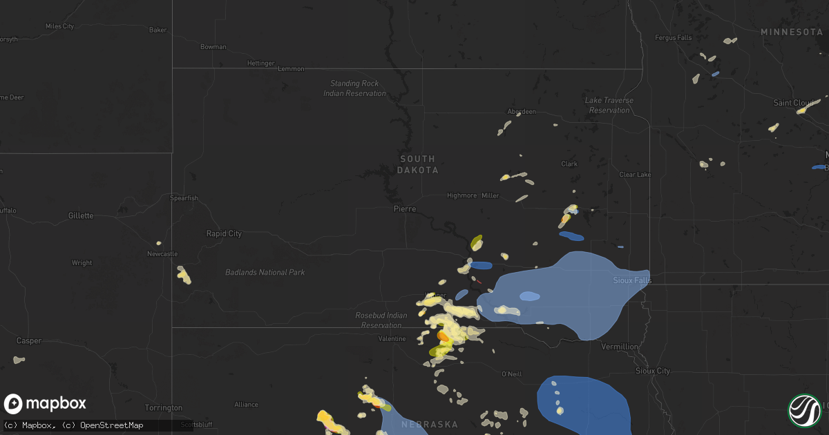
Hail Map in South Dakota on July 15, 2025
Get this storm
July 15 map
$229
one time, instant access
Download today. No call, no setup
Keep the $229
Bought the map and want the full workflow? Apply the entire $229 to a subscription within 7 days. None of it is wasted.
Every map, not just this one
This buys you this map. Subscription and you get every map we run, in the markets you choose from a few cities to whole states to nationwide. Plus real-time alerts the moment a storm fires.
Contact data
Name, contact info, occupancy, even credit band for addresses in the footprint. You go from where it hit to who to call.
Become the source they trust
Unlimited branding weather history reports on demand. You already have the documented answer ready for the property owner, and you are the one who showed up with it.
Property data and RoofTrace estimates
Pull up any address you have got, its value and the exact code rules for that jurisdiction, straight from One Click Code. Then RoofTrace estimates the squares, pitch, and roof value, priced the way you price.
Storm reports in South Dakota
South Dakota
| Date | Description |
|---|---|
| 07/15/20256:28 PM CDT | Personal weather station. |
| 07/15/20256:25 PM CDT | Personal weather station. |
| 07/15/20256:25 PM CDT | Personal weather station. |
| 07/15/20256:25 PM CDT | Mesonet station 304 sd rwis corsica. |
| 07/15/20256:20 PM CDT | Personal weather station. |
| 07/15/20256:20 PM CDT | Mesonet station 304 sd rwis corsica. |
| 07/15/20256:11 PM CDT | Damage across town included uprooted tree... Roof and siding damage from flying debris... Damage to metal barn and a bent street sign. |
| 07/15/20256:08 PM CDT | Mesonet station 244 sd rwis ft. Randall dam. |
| 07/15/20256:08 PM CDT | A local report indicates 1.00 inch wind near 4 W De Smet |
| 07/15/20256:05 PM CDT | Personal weather station. |
| 07/15/20255:55 PM CDT | A local report indicates 60 MPH wind near Bonesteel |
| 07/15/20255:46 PM CDT | Mesonet station rlas2 lake andes raws. |
| 07/15/20255:32 PM CDT | Personal weather station. |
| 07/15/20255:17 PM CDT | Personal weather station. |
| 07/15/20255:01 PM CDT | In addition to hail up to half dollar size... Heavy rain and 40-50 mph wind gusts stripped some leaves from trees. |
| 07/15/20254:42 PM CDT | Mesonet station 283 sd rwis dixon. |
| 07/15/20254:38 PM CDT | A local report indicates 1.00 inch wind near 3 NNE Wewela |
| 07/15/20254:35 PM CDT | In addition to a few quarter sized hail stones... Rainfall was about 0.30 to 0.40 inch. |
| 07/15/20254:09 PM CDT | A local report indicates 1.50 inch wind near 2 W Clearfield |
| 07/15/20254:03 PM CDT | A local report indicates 1.00 inch wind near 5 SSE Winner |
| 07/14/20258:48 PM CDT | Personal weather station. |
| 07/14/20258:45 PM CDT | Via personal weather station. |
| 07/14/20258:35 PM CDT | Wind gusts estimated at 60-65 mph knocked a couple trees down. Heavy rain followed... Reducing visibility to about 100 feet . |
| 07/14/20258:22 PM CDT | Mesonet station 18 sd rwis montrose. |
| 07/14/20257:42 PM CDT | Mesonet station 163 sd rwis freeman. Initial severe gust at 742 pm with a peak gust of 61 mph at 744 pm. |
| 07/14/20257:38 PM CDT | Tree down blocking the road near 3rd and cherry. Via social media. |
| 07/14/20257:36 PM CDT | Measured by personal weather station. First severe gust at 736 pm at 61 mph... And 66 mph at 741 pm. |
| 07/14/20257:25 PM CDT | Mesonet station 297 sd rwis howard. |
| 07/14/20257:07 PM CDT | Strong wind gusts pushed through town... Breaking many tree branches... Blowing out a grain bin... And registering about 53 mph at the airport. |
| 07/14/20257:06 PM CDT | Personal weather station. |
All States Impacted by Hail Map on July 15, 2025
Cities Impacted by Hail Map on July 15, 2025
- Odonnell, TX
- Lamesa, TX
- Onamia, MN
- McGrath, MN
- Isle, MN
- Wahkon, MN
- Finlayson, MN
- Hayward, WI
- Askov, MN
- Barnum, MN
- Moose Lake, MN
- Carlton, MN
- Superior, WI
- Wrenshall, MN
- Kerrick, MN
- Holyoke, MN
- Foxboro, WI
- South Range, WI
- Solon Springs, WI
- Willow River, MN
- Lake Nebagamon, WI
- Bristol, FL
- Sandstone, MN
- Brule, WI
- Iron River, WI
- Hoffman, MN
- Mass City, MI
- Nisula, MI
- Aberdeen, SD
- Mansfield, SD
- Kensington, MN
- Trout Creek, MI
- Bruce Crossing, MI
- Cresbard, SD
- Evansville, MN
- Brandon, MN
- Ipswich, SD
- Kettle River, MN
- Lanse, MI
- Port Saint Joe, FL
- Pelkie, MI
- Alexandria, MN
- Cloquet, MN
- Edgemont, SD
- Ashland, WI
- Parkers Prairie, MN
- Skanee, MI
- Garfield, MN
- Miltona, MN
- Winner, SD
- Montevideo, MN
- Granite Falls, MN
- Saxon, WI
- Panama City, FL
- Bertha, MN
- Hewitt, MN
- Gordon, WI
- Eden Valley, MN
- Watkins, MN
- Ironwood, MI
- Cromwell, MN
- Sawyer, MN
- McLeansville, NC
- Youngstown, FL
- Litchfield, MN
- Mason, WI
- Maynard, MN
- Sacred Heart, MN
- Custer, SD
- Chiefland, FL
- Ideal, SD
- Hamill, SD
- Wood River, IL
- Lynn Haven, FL
- Colome, SD
- Valentine, NE
- Hyannis, NE
- Two Harbors, MN
- Westlake, LA
- Gregory, SD
- Whitman, NE
- Saint Cloud, MN
- Clear Lake, MN
- Clearwater, MN
- Clara City, MN
- Chamberlain, SD
- Roxana, IL
- Edwardsville, IL
- South Roxana, IL
- Griffin, GA
- Dallas, SD
- Panama City Beach, FL
- Ashford, AL
- Pukwana, SD
- Trego, WI
- Chipley, FL
- Saint Anthony, ID
- Parker, ID
- Sturgeon Lake, MN
- Princeton, MN
- Foley, MN
- Burke, SD
- Hill City, SD
- Rexburg, ID
- Fort Thompson, SD
- Danbury, WI
- Spooner, WI
- Minong, WI
- Webster, WI
- Cambridge, MN
- Vernon, FL
- Williamson, GA
- Seneca, NE
- Thedford, NE
- Springview, NE
- Crowheart, WY
- Braham, MN
- Stanchfield, MN
- Cusseta, GA
- Daleville, AL
- Mills, NE
- Platte, SD
- Heber, AZ
- Newcastle, WY
- Isanti, MN
- Hinckley, MN
- Show Low, AZ
- Hartford, AL
- Tulare, SD
- Saint Lawrence, SD
- White Lake, SD
- Grandy, MN
- Rush City, MN
- Harris, MN
- Herrick, SD
- Mullen, NE
- Dayton, MN
- Anoka, MN
- Arthur, NE
- Riverton, WY
- Ainsworth, NE
- Bonesteel, SD
- Saint Charles, SD
- Fairfax, SD
- Geddes, SD
- Kimball, SD
- Long Pine, NE
- Bassett, NE
- Iroquois, SD
- De Smet, SD
- Tryon, NE
- Johnstown, NE
- Andover, MN
- Redfield, SD
- Patagonia, AZ
- Fort Washakie, WY
- Lander, WY
- Waconia, MN
- Cologne, MN
- Lake Andes, SD
- Armour, SD
- Corsica, SD
- Harrison, SD
- New Holland, SD
- Wagner, SD
- Osseo, MN
- Champlin, MN
- Frederic, WI
- Statesville, NC
- Woonsocket, SD
- Shell Lake, WI
- Naper, NE
- Minneapolis, MN
- Stickney, SD
- Plankinton, SD
- Springbrook, WI
- Fort Walton Beach, FL
- Shalimar, FL
- Hertel, WI
- Ashton, SD
- Midway, AL
- Clayton, AL
- Andover, SD
- Stuart, NE
- Chaska, MN
- Victoria, MN
- Pickstown, SD
- Union Springs, AL
- Alvord, TX
- Sunset, TX
- Louisville, AL
- Hudson, WY
- Fedora, SD
- Artesian, SD
- Carthage, SD
- Sutherland, NE
- Bryant, SD
- Willow Lake, SD
- Stapleton, NE
- Atkinson, NE
- Howard, SD
- Halsey, NE
- Arnold, NE
- Purdum, NE
- Dunning, NE
- Anselmo, NE
- Winter, WI
- Dante, SD
- Lake Preston, SD
- Forestburg, TX
- Banks, AL
- Mount Vernon, SD
- Parkston, SD
- Ethan, SD
- Dimock, SD
- Mitchell, SD
- Delmont, SD
- Avon, SD
- Tripp, SD
- Jeffrey City, WY
- Park Falls, WI
- Butternut, WI
- Mellen, WI
- Clam Lake, WI
- Cable, WI
- Marengo, WI
- Merna, NE
- Broken Bow, NE
- Callaway, NE
- Brady, NE
- Glidden, WI
- Lytle, TX
- Poteet, TX
- Somerset, TX
- Alexandria, SD
- Tyndall, SD
- Freeman, SD
- Kaylor, SD
- Emery, SD
- Scotland, SD
- Menno, SD
- Olivet, SD
- Lesterville, SD
- Bridgewater, SD
- Spencer, SD
- Fulton, SD
- Salem, SD
- Canova, SD
- Wilson, OK
- Ardmore, OK
- Gothenburg, NE
- Maxwell, NE
- North Platte, NE
- Wolsey, SD
- Hitchcock, SD
- Troy, AL
- Kit Carson, CO
- Casper, WY
- Mercer, WI
- Yankton, SD
- Irene, SD
- Utica, SD
- Tabor, SD
- Crofton, NE
- Saint Helena, NE
- Mission Hill, SD
- Marion, SD
- Viborg, SD
- Canistota, SD
- Montrose, SD
- Marenisco, MI
- Gainesville, TX
- Volin, SD
- Humboldt, SD
- Hurley, SD
- Monroe, SD
- Davis, SD
- Centerville, SD
- Parker, SD
- Chancellor, SD
- Wakonda, SD
- Gayville, SD
- Vermillion, SD
- Lennox, SD
- Hartford, SD
- Rawlins, WY
- Star, NC
- Shoshoni, WY
- Thermopolis, WY
- Manitowish Waters, WI
- Presque Isle, WI
- Boulder Junction, WI
- Sioux Falls, SD
- Harrisburg, SD
- Tea, SD
- Worthing, SD
- Pierce, NE
- Tilden, NE
- Orchard, NE
- Brunswick, NE
- Petersburg, NE
- Clearwater, NE
- Elgin, NE
- Plainview, NE
- Royal, NE
- Oakdale, NE
- Neligh, NE
- Osmond, NE
- Ewing, NE
- Meadow Grove, NE
- Ansley, NE
- Saint Jo, TX
- Burwell, NE
- Seagrove, NC
- Land O'Lakes, WI
- Canton, SD
- Crooks, SD
- Renner, SD
- Hoskins, NE
- Carroll, NE
- Winside, NE
- Randolph, NE
- Norfolk, NE
- Wayne, NE
- Belden, NE
- Mclean, NE
- Watersmeet, MI
- Brandon, SD
- Larchwood, IA
- Madison, NE
- Battle Creek, NE
- Hurley, WI
- Roberts, ID
- Hanna, WY
- Ada, OK
- Elyria, NE
- McDonald, KS
- Chambers, NE
- Ewen, MI
- Pilger, NE
- Wakefield, NE
- Pender, NE
- Wisner, NE
- Stanton, NE
- Newman Grove, NE
- Wausa, NE
- Creighton, NE
- Greeley, NE
- Ord, NE
- Bartlett, NE
- Ericson, NE
- Farnam, NE
- Moorefield, NE
- Curtis, NE
- Maywood, NE
- Maricopa, AZ
- Scotia, NE
- Konawa, OK
- Valley Springs, SD
- Garretson, SD
- Beaver Creek, MN
- Eustis, NE
- Sells, AZ
- Cozad, NE
- Spalding, NE
- Stockville, NE
- Wellfleet, NE
- Lindsay, NE
- Leigh, NE
- Humphrey, NE
- Lava Hot Springs, ID
- Snowville, UT
- Grace, ID
- Mccammon, ID
- Holbrook, ID
- Malad City, ID
- Downey, ID
- Arimo, ID
- Saint Paul, NE
- Elwood, NE
- Wolbach, NE
- Oconto, NE
- Big Piney, WY
- Daniel, WY
- Rock Springs, WY
- Wamsutter, WY
- Dubois, WY
- Bartley, NE
- Palmer, NE
- Ririe, ID
- Swan Valley, ID
- Malta, ID
- Park Valley, UT
- Howells, NE
- Clarkson, NE
- Beemer, NE
- Creston, NE
- Bancroft, NE
- West Point, NE
- Dodge, NE
- Schuyler, NE
- Burneyville, OK
- Holbrook, NE
- Snyder, NE
- Rogers, NE
- North Bend, NE
- Scribner, NE
- Laurel, NE
- Axtell, NE
- Lexington, NE
- Linwood, NE
- Bellwood, NE
- Columbus, NE
- David City, NE
- Kearney, NE
- Minden, NE
- Brainard, NE
- Bruno, NE
- Prague, NE
- Morse Bluff, NE
- Abie, NE
- Smithfield, NE
- Bertrand, NE
- Weston, NE
- Wahoo, NE
- Cedar Bluffs, NE
- Malmo, NE
- Colon, NE
- Ceresco, NE
- Valparaiso, NE
- Fremont, NE
- Ames, NE
- Hooper, NE
- Overton, NE
- Elm Creek, NE
- Dwight, NE
- Bee, NE
- Raymond, NE
- Pleasant Dale, NE
- Malcolm, NE
- Garland, NE
- Lincoln, NE
- Davey, NE
- Ithaca, NE
- Mead, NE
- Yutan, NE
- Ashland, NE
- Waverly, NE
- Roca, NE
- Memphis, NE
- Greenwood, NE
- Waterloo, NE
- Valley, NE
- Murdock, NE
- Omaha, NE
- La Vista, NE
- Springfield, NE
- South Bend, NE
- Louisville, NE
- Walton, NE
- Elkhorn, NE
- Eagle, NE
- Papillion, NE
- Gretna, NE
- Alvo, NE
- Bellevue, NE
- Boys Town, NE
- Funk, NE
- Hills, MN
- Council Bluffs, IA
- Bennington, NE
- Carter Lake, IA
- Hickman, NE
- Elmwood, NE
- Cedar Creek, NE
- Bennet, NE
- Colman, SD
- Wentworth, SD
- Chester, SD
- Odessa, NE
- Winfred, SD
- Colton, SD
- Amherst, NE
- Riverdale, NE
- Pleasanton, NE
- Gibbon, NE
- Shelton, NE
- Unadilla, NE
- Manley, NE
- Adams, NE
- Plattsmouth, NE
- Palmyra, NE
- Avoca, NE
- Weeping Water, NE
- Syracuse, NE
- Murray, NE
- Pacific Junction, IA
- Otoe, NE
- Offutt Afb, NE
- Nehawka, NE
- Fort Calhoun, NE
- Kenesaw, NE
- Wood River, NE
- Heartwell, NE
- Clifton, KS
- Linn, KS
- Casa Grande, AZ
- Denton, NE
- Crescent, IA
- Doniphan, NE
- Trumbull, NE
- Giltner, NE
- Hastings, NE
- Juniata, NE
- Harvard, NE
- Aurora, NE
- Tuskegee, AL
- Olsburg, KS
- Saronville, NE
- Sutton, NE
- Henderson, NE
- Grafton, NE
- Fairmont, NE
- Exeter, NE
- Friend, NE
- Dorchester, NE
- Crete, NE
- Milligan, NE
- Western, NE
- Wilber, NE


