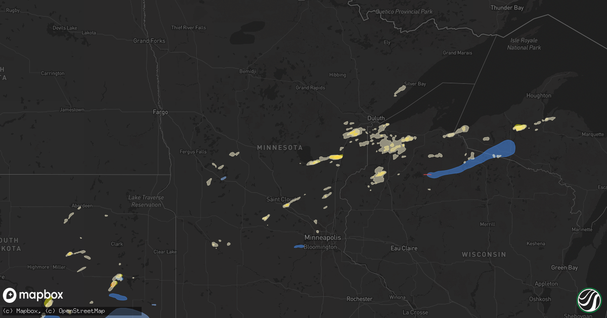
Hail Map in Minnesota on July 15, 2025
Get this storm
July 15 map
$229
one time, instant access
Download today. No call, no setup
Keep the $229
Bought the map and want the full workflow? Apply the entire $229 to a subscription within 7 days. None of it is wasted.
Every map, not just this one
This buys you this map. Subscription and you get every map we run, in the markets you choose from a few cities to whole states to nationwide. Plus real-time alerts the moment a storm fires.
Contact data
Name, contact info, occupancy, even credit band for addresses in the footprint. You go from where it hit to who to call.
Become the source they trust
Unlimited branding weather history reports on demand. You already have the documented answer ready for the property owner, and you are the one who showed up with it.
Property data and RoofTrace estimates
Pull up any address you have got, its value and the exact code rules for that jurisdiction, straight from One Click Code. Then RoofTrace estimates the squares, pitch, and roof value, priced the way you price.
Storm reports in Minnesota
Minnesota
| Date | Description |
|---|---|
| 07/15/20254:28 PM CDT | Delayed lsr - report from sheriffs dispatch of a tree down along a road in becker township. Time estimated via radar. |
| 07/15/20254:15 PM CDT | Delayed report of large branch snapped off a willow tree near darling township. Photo shared via facebook. Time estimated from radar. |
| 07/15/20254:15 PM CDT | Delayed report. Time estimated from radar. Snapped trees on county rd 16 off hwy 10. |
| 07/15/20254:15 PM CDT | Delayed report. Time estimated via radar. Substantial tree damage with snapped trees and debris in road. |
| 07/15/20254:12 PM CDT | Public report of trees down near us10 south of motley. Relayed via county dispatch. |
| 07/15/20254:09 PM CDT | Corrects previous tstm wnd dmg report from 4 nne nemadji. Multiple trees and a flagpole were downed at the reporters location. Time estimated by radar. |
| 07/15/20254:00 PM CDT | Delayed report. Many trees damaged and stripped of leaves. |
| 07/15/20253:59 PM CDT | Delayed lsr - photo or large tree branches snapped 4 miles south of luxemburg. |
| 07/15/20253:09 PM CDT | Multiple trees and a flagpole were downed at the reporters location. Time estimated by radar. |
| 07/15/20253:09 PM CDT | Corrects previous tstm wnd dmg report from 4 nne nemadji. Corrects previous tstm wnd dmg report from 4 nne nemadji. Multiple trees and a flagpole were downed at the rep |
| 07/15/20252:53 PM CDT | Asos station kaxn alexandria mn asos. |
| 07/15/20258:25 AM CDT | Report via social media with photo. |
| 07/15/20258:21 AM CDT | Report via social media. Time estimated from radar. |
| 07/15/20258:20 AM CDT | A local report indicates 1.00 inch wind near 2 W Finlayson |
All States Impacted by Hail Map on July 15, 2025
Cities Impacted by Hail Map on July 15, 2025
- Odonnell, TX
- Lamesa, TX
- Onamia, MN
- McGrath, MN
- Isle, MN
- Wahkon, MN
- Finlayson, MN
- Hayward, WI
- Askov, MN
- Barnum, MN
- Moose Lake, MN
- Carlton, MN
- Superior, WI
- Wrenshall, MN
- Kerrick, MN
- Holyoke, MN
- Foxboro, WI
- South Range, WI
- Solon Springs, WI
- Willow River, MN
- Lake Nebagamon, WI
- Bristol, FL
- Sandstone, MN
- Brule, WI
- Iron River, WI
- Hoffman, MN
- Mass City, MI
- Nisula, MI
- Aberdeen, SD
- Mansfield, SD
- Kensington, MN
- Trout Creek, MI
- Bruce Crossing, MI
- Cresbard, SD
- Evansville, MN
- Brandon, MN
- Ipswich, SD
- Kettle River, MN
- Lanse, MI
- Port Saint Joe, FL
- Pelkie, MI
- Alexandria, MN
- Cloquet, MN
- Edgemont, SD
- Ashland, WI
- Parkers Prairie, MN
- Skanee, MI
- Garfield, MN
- Miltona, MN
- Winner, SD
- Montevideo, MN
- Granite Falls, MN
- Saxon, WI
- Panama City, FL
- Bertha, MN
- Hewitt, MN
- Gordon, WI
- Eden Valley, MN
- Watkins, MN
- Ironwood, MI
- Cromwell, MN
- Sawyer, MN
- McLeansville, NC
- Youngstown, FL
- Litchfield, MN
- Mason, WI
- Maynard, MN
- Sacred Heart, MN
- Custer, SD
- Chiefland, FL
- Ideal, SD
- Hamill, SD
- Wood River, IL
- Lynn Haven, FL
- Colome, SD
- Valentine, NE
- Hyannis, NE
- Two Harbors, MN
- Westlake, LA
- Gregory, SD
- Whitman, NE
- Saint Cloud, MN
- Clear Lake, MN
- Clearwater, MN
- Clara City, MN
- Chamberlain, SD
- Roxana, IL
- Edwardsville, IL
- South Roxana, IL
- Griffin, GA
- Dallas, SD
- Panama City Beach, FL
- Ashford, AL
- Pukwana, SD
- Trego, WI
- Chipley, FL
- Saint Anthony, ID
- Parker, ID
- Sturgeon Lake, MN
- Princeton, MN
- Foley, MN
- Burke, SD
- Hill City, SD
- Rexburg, ID
- Fort Thompson, SD
- Danbury, WI
- Spooner, WI
- Minong, WI
- Webster, WI
- Cambridge, MN
- Vernon, FL
- Williamson, GA
- Seneca, NE
- Thedford, NE
- Springview, NE
- Crowheart, WY
- Braham, MN
- Stanchfield, MN
- Cusseta, GA
- Daleville, AL
- Mills, NE
- Platte, SD
- Heber, AZ
- Newcastle, WY
- Isanti, MN
- Hinckley, MN
- Show Low, AZ
- Hartford, AL
- Tulare, SD
- Saint Lawrence, SD
- White Lake, SD
- Grandy, MN
- Rush City, MN
- Harris, MN
- Herrick, SD
- Mullen, NE
- Dayton, MN
- Anoka, MN
- Arthur, NE
- Riverton, WY
- Ainsworth, NE
- Bonesteel, SD
- Saint Charles, SD
- Fairfax, SD
- Geddes, SD
- Kimball, SD
- Long Pine, NE
- Bassett, NE
- Iroquois, SD
- De Smet, SD
- Tryon, NE
- Johnstown, NE
- Andover, MN
- Redfield, SD
- Patagonia, AZ
- Fort Washakie, WY
- Lander, WY
- Waconia, MN
- Cologne, MN
- Lake Andes, SD
- Armour, SD
- Corsica, SD
- Harrison, SD
- New Holland, SD
- Wagner, SD
- Osseo, MN
- Champlin, MN
- Frederic, WI
- Statesville, NC
- Woonsocket, SD
- Shell Lake, WI
- Naper, NE
- Minneapolis, MN
- Stickney, SD
- Plankinton, SD
- Springbrook, WI
- Fort Walton Beach, FL
- Shalimar, FL
- Hertel, WI
- Ashton, SD
- Midway, AL
- Clayton, AL
- Andover, SD
- Stuart, NE
- Chaska, MN
- Victoria, MN
- Pickstown, SD
- Union Springs, AL
- Alvord, TX
- Sunset, TX
- Louisville, AL
- Hudson, WY
- Fedora, SD
- Artesian, SD
- Carthage, SD
- Sutherland, NE
- Bryant, SD
- Willow Lake, SD
- Stapleton, NE
- Atkinson, NE
- Howard, SD
- Halsey, NE
- Arnold, NE
- Purdum, NE
- Dunning, NE
- Anselmo, NE
- Winter, WI
- Dante, SD
- Lake Preston, SD
- Forestburg, TX
- Banks, AL
- Mount Vernon, SD
- Parkston, SD
- Ethan, SD
- Dimock, SD
- Mitchell, SD
- Delmont, SD
- Avon, SD
- Tripp, SD
- Jeffrey City, WY
- Park Falls, WI
- Butternut, WI
- Mellen, WI
- Clam Lake, WI
- Cable, WI
- Marengo, WI
- Merna, NE
- Broken Bow, NE
- Callaway, NE
- Brady, NE
- Glidden, WI
- Lytle, TX
- Poteet, TX
- Somerset, TX
- Alexandria, SD
- Tyndall, SD
- Freeman, SD
- Kaylor, SD
- Emery, SD
- Scotland, SD
- Menno, SD
- Olivet, SD
- Lesterville, SD
- Bridgewater, SD
- Spencer, SD
- Fulton, SD
- Salem, SD
- Canova, SD
- Wilson, OK
- Ardmore, OK
- Gothenburg, NE
- Maxwell, NE
- North Platte, NE
- Wolsey, SD
- Hitchcock, SD
- Troy, AL
- Kit Carson, CO
- Casper, WY
- Mercer, WI
- Yankton, SD
- Irene, SD
- Utica, SD
- Tabor, SD
- Crofton, NE
- Saint Helena, NE
- Mission Hill, SD
- Marion, SD
- Viborg, SD
- Canistota, SD
- Montrose, SD
- Marenisco, MI
- Gainesville, TX
- Volin, SD
- Humboldt, SD
- Hurley, SD
- Monroe, SD
- Davis, SD
- Centerville, SD
- Parker, SD
- Chancellor, SD
- Wakonda, SD
- Gayville, SD
- Vermillion, SD
- Lennox, SD
- Hartford, SD
- Rawlins, WY
- Star, NC
- Shoshoni, WY
- Thermopolis, WY
- Manitowish Waters, WI
- Presque Isle, WI
- Boulder Junction, WI
- Sioux Falls, SD
- Harrisburg, SD
- Tea, SD
- Worthing, SD
- Pierce, NE
- Tilden, NE
- Orchard, NE
- Brunswick, NE
- Petersburg, NE
- Clearwater, NE
- Elgin, NE
- Plainview, NE
- Royal, NE
- Oakdale, NE
- Neligh, NE
- Osmond, NE
- Ewing, NE
- Meadow Grove, NE
- Ansley, NE
- Saint Jo, TX
- Burwell, NE
- Seagrove, NC
- Land O'Lakes, WI
- Canton, SD
- Crooks, SD
- Renner, SD
- Hoskins, NE
- Carroll, NE
- Winside, NE
- Randolph, NE
- Norfolk, NE
- Wayne, NE
- Belden, NE
- Mclean, NE
- Watersmeet, MI
- Brandon, SD
- Larchwood, IA
- Madison, NE
- Battle Creek, NE
- Hurley, WI
- Roberts, ID
- Hanna, WY
- Ada, OK
- Elyria, NE
- McDonald, KS
- Chambers, NE
- Ewen, MI
- Pilger, NE
- Wakefield, NE
- Pender, NE
- Wisner, NE
- Stanton, NE
- Newman Grove, NE
- Wausa, NE
- Creighton, NE
- Greeley, NE
- Ord, NE
- Bartlett, NE
- Ericson, NE
- Farnam, NE
- Moorefield, NE
- Curtis, NE
- Maywood, NE
- Maricopa, AZ
- Scotia, NE
- Konawa, OK
- Valley Springs, SD
- Garretson, SD
- Beaver Creek, MN
- Eustis, NE
- Sells, AZ
- Cozad, NE
- Spalding, NE
- Stockville, NE
- Wellfleet, NE
- Lindsay, NE
- Leigh, NE
- Humphrey, NE
- Lava Hot Springs, ID
- Snowville, UT
- Grace, ID
- Mccammon, ID
- Holbrook, ID
- Malad City, ID
- Downey, ID
- Arimo, ID
- Saint Paul, NE
- Elwood, NE
- Wolbach, NE
- Oconto, NE
- Big Piney, WY
- Daniel, WY
- Rock Springs, WY
- Wamsutter, WY
- Dubois, WY
- Bartley, NE
- Palmer, NE
- Ririe, ID
- Swan Valley, ID
- Malta, ID
- Park Valley, UT
- Howells, NE
- Clarkson, NE
- Beemer, NE
- Creston, NE
- Bancroft, NE
- West Point, NE
- Dodge, NE
- Schuyler, NE
- Burneyville, OK
- Holbrook, NE
- Snyder, NE
- Rogers, NE
- North Bend, NE
- Scribner, NE
- Laurel, NE
- Axtell, NE
- Lexington, NE
- Linwood, NE
- Bellwood, NE
- Columbus, NE
- David City, NE
- Kearney, NE
- Minden, NE
- Brainard, NE
- Bruno, NE
- Prague, NE
- Morse Bluff, NE
- Abie, NE
- Smithfield, NE
- Bertrand, NE
- Weston, NE
- Wahoo, NE
- Cedar Bluffs, NE
- Malmo, NE
- Colon, NE
- Ceresco, NE
- Valparaiso, NE
- Fremont, NE
- Ames, NE
- Hooper, NE
- Overton, NE
- Elm Creek, NE
- Dwight, NE
- Bee, NE
- Raymond, NE
- Pleasant Dale, NE
- Malcolm, NE
- Garland, NE
- Lincoln, NE
- Davey, NE
- Ithaca, NE
- Mead, NE
- Yutan, NE
- Ashland, NE
- Waverly, NE
- Roca, NE
- Memphis, NE
- Greenwood, NE
- Waterloo, NE
- Valley, NE
- Murdock, NE
- Omaha, NE
- La Vista, NE
- Springfield, NE
- South Bend, NE
- Louisville, NE
- Walton, NE
- Elkhorn, NE
- Eagle, NE
- Papillion, NE
- Gretna, NE
- Alvo, NE
- Bellevue, NE
- Boys Town, NE
- Funk, NE
- Hills, MN
- Council Bluffs, IA
- Bennington, NE
- Carter Lake, IA
- Hickman, NE
- Elmwood, NE
- Cedar Creek, NE
- Bennet, NE
- Colman, SD
- Wentworth, SD
- Chester, SD
- Odessa, NE
- Winfred, SD
- Colton, SD
- Amherst, NE
- Riverdale, NE
- Pleasanton, NE
- Gibbon, NE
- Shelton, NE
- Unadilla, NE
- Manley, NE
- Adams, NE
- Plattsmouth, NE
- Palmyra, NE
- Avoca, NE
- Weeping Water, NE
- Syracuse, NE
- Murray, NE
- Pacific Junction, IA
- Otoe, NE
- Offutt Afb, NE
- Nehawka, NE
- Fort Calhoun, NE
- Kenesaw, NE
- Wood River, NE
- Heartwell, NE
- Clifton, KS
- Linn, KS
- Casa Grande, AZ
- Denton, NE
- Crescent, IA
- Doniphan, NE
- Trumbull, NE
- Giltner, NE
- Hastings, NE
- Juniata, NE
- Harvard, NE
- Aurora, NE
- Tuskegee, AL
- Olsburg, KS
- Saronville, NE
- Sutton, NE
- Henderson, NE
- Grafton, NE
- Fairmont, NE
- Exeter, NE
- Friend, NE
- Dorchester, NE
- Crete, NE
- Milligan, NE
- Western, NE
- Wilber, NE


