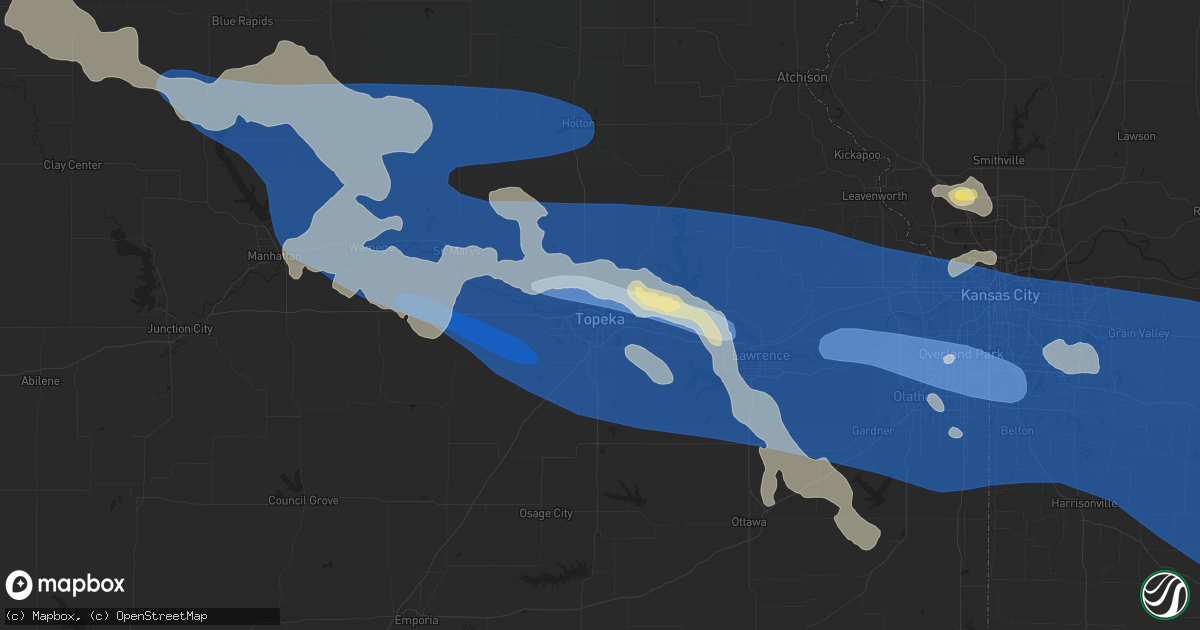
Hail Map in Topeka, KS on July 14, 2023
Get this storm
July 14 map
$229
one time, instant access
Download today. No call, no setup
Keep the $229
Bought the map and want the full workflow? Apply the entire $229 to a subscription within 7 days. None of it is wasted.
Every map, not just this one
This buys you this map. Subscription and you get every map we run, in the markets you choose from a few cities to whole states to nationwide. Plus real-time alerts the moment a storm fires.
Contact data
Name, contact info, occupancy, even credit band for addresses in the footprint. You go from where it hit to who to call.
Become the source they trust
Unlimited branding weather history reports on demand. You already have the documented answer ready for the property owner, and you are the one who showed up with it.
Property data and RoofTrace estimates
Pull up any address you have got, its value and the exact code rules for that jurisdiction, straight from One Click Code. Then RoofTrace estimates the squares, pitch, and roof value, priced the way you price.
Storm reports in Topeka, KS
Topeka, KS
| Date | Description |
|---|---|
| 07/14/20233:16 PM CDT | Report from mping: 1-inch tree limbs broken; shingles blown off. |
| 07/14/20232:41 PM CDT | Report from mping: 1-inch tree limbs broken; shingles blown off. |
| 07/14/20232:31 PM CDT | Report from mping: 1-inch tree limbs broken; shingles blown off. |
| 07/14/20232:30 PM CDT | Union and pacific station. |
| 07/14/20232:30 PM CDT | Many tree limbs around 3 inches in diameter down on road. |
| 07/14/20232:30 PM CDT | Estimated 8 inch tree limbs down. Time estimated from radar data. |
| 07/14/20232:29 PM CDT | Ktop asos. |
| 07/14/20232:28 PM CDT | Kansas state mesonet. |
| 07/14/20232:28 PM CDT | Asos station ktop topeka. |
| 07/14/20232:25 PM CDT | 60-70 estimated. |
| 07/14/20232:24 PM CDT | Kansas state mesonet. |
| 07/14/20232:20 PM CDT | Estimated wind gusts to 60. |
| 07/14/20231:50 PM CDT | Significant tree damage as well as power outages in town. |
All States Impacted by Hail Map on July 14, 2023
All Cities Impacted by Hail Map on July 14, 2023
- West Alexander, PA
- Valley Grove, WV
- Claysville, PA
- Avella, PA
- Washington, PA
- Lebanon, PA
- Myerstown, PA
- Marshalltown, IA
- Albion, IA
- Gilman, IA
- Ferguson, IA
- Grinnell, IA
- Kellogg, IA
- Roland, OK
- Muldrow, OK
- Van Buren, AR
- Fort Smith, AR
- Arkoma, OK
- Greenwood, AR
- Lavaca, AR
- Barling, AR
- Huntington, AR
- Hackett, AR
- Mansfield, AR
- Hartford, AR
- Waldron, AR
- Booneville, AR
- Clayton, NM
- Dalhart, TX
- Felt, OK
- Texline, TX
- Hartley, TX
- Skellytown, TX
- Borger, TX
- Pampa, TX
- Charleston, AR
- Alma, AR
- Magazine, AR
- Branch, AR
- Mullen, NE
- Tryon, NE
- North Platte, NE
- Stapleton, NE
- Maxwell, NE
- Brady, NE
- Keystone, NE
- Paxton, NE
- Sutherland, NE
- Hershey, NE
- Gothenburg, NE
- Callaway, NE
- Whitman, NE
- Maywood, NE
- Curtis, NE
- Hayes Center, NE
- McCook, NE
- Cambridge, NE
- Eustis, NE
- Stockville, NE
- Moorefield, NE
- Holbrook, NE
- Arapahoe, NE
- Bartley, NE
- Indianola, NE
- Hendley, NE
- Stamford, NE
- Norton, KS
- Edison, NE
- Beaver City, NE
- Wilsonville, NE
- Lebanon, NE
- Almena, KS
- Oxford, NE
- Long Island, KS
- Prairie View, KS
- Phillipsburg, KS
- Plainville, KS
- Ellis, KS
- Glade, KS
- Hays, KS
- Victoria, KS
- Walker, KS
- Franklin, WV
- Hill City, KS
- Penokee, KS
- Barnes, KS
- Waterville, KS
- Randolph, KS
- Olsburg, KS
- Blue Rapids, KS
- Westmoreland, KS
- Abbeville, MS
- Oxford, MS
- Thaxton, MS
- Etta, MS
- Ecru, MS
- Pontotoc, MS
- New Albany, MS
- Wakeeney, KS
- Ogallah, KS
- Hoxie, KS
- Morland, KS
- Palco, KS
- Manhattan, KS
- Saint George, KS
- Wamego, KS
- Onaga, KS
- Kirwin, KS
- Alton, KS
- Woodston, KS
- Gaylord, KS
- Stockton, KS
- Portis, KS
- Osborne, KS
- Cedar, KS
- Agra, KS
- Blue Springs, MS
- La Crosse, KS
- Schoenchen, KS
- Pfeifer, KS
- Bison, KS
- Lexington, NE
- Haddam, KS
- Big Springs, WV
- Grantsville, WV
- Scandia, KS
- Wallace, NE
- Elsie, NE
- Frankfort, KS
- Republic, KS
- Birch Tree, MO
- Alma, NE
- Orleans, NE
- Mahopac, NY
- Arthur, NE
- Bogue, KS
- Damar, KS
- Clifton, KS
- Clyde, KS
- Cutler, OH
- Webber, KS
- Courtland, KS
- Superior, NE
- Hardy, NE
- Gorham, KS
- Dickens, NE
- Ogallala, NE
- Russell, KS
- Belleville, WV
- Washington, WV
- Coolville, OH
- Lewellen, NE
- Norcatur, KS
- Palmer, KS
- Linn, KS
- Saint Louis, MO
- East Carondelet, IL
- Oberlin, KS
- Danbury, NE
- Farmington, CT
- Bristol, CT
- Plainville, CT
- Wolcott, CT
- Unionville, CT
- Kensington, KS
- Morrowville, KS
- Sylvan Grove, KS
- Kewadin, MI
- Belleville, KS
- Concordia, KS
- Guysville, OH
- Mineral Wells, WV
- Little Hocking, OH
- Parkersburg, WV
- Greenleaf, KS
- Sarah, MS
- Elwood, NE
- Wellfleet, NE
- Doniphan, MO
- Alton, MO
- Walker, WV
- Petroleum, WV
- Bertrand, NE
- Black Oak, AR
- Mammoth Spring, AR
- Dresden, KS
- Selden, KS
- Republican City, NE
- Natoma, KS
- Rison, AR
- Guide Rock, NE
- Logan, KS
- Farnam, NE
- Reedsville, OH
- Athens, OH
- Green, KS
- Lenora, KS
- Osceola, AR
- Etowah, AR
- Randolph, MS
- Myrtle, MS
- West Plains, MO
- Paxico, KS
- Belvue, KS
- Alma, KS
- Maple Hill, KS
- Capon Bridge, WV
- Gore, VA
- Cross Junction, VA
- Kanopolis, KS
- Ellsworth, KS
- Wilson, KS
- Lorraine, KS
- Beverly, KS
- Lincoln, KS
- Olmitz, KS
- Hoisington, KS
- Great Bend, KS
- St John, KS
- Albert, KS
- Otis, KS
- Hudson, KS
- Ellinwood, KS
- Winchester, VA
- Auburn, KS
- Harveyville, KS
- Topeka, KS
- Soldier, KS
- Holton, KS
- Havensville, KS
- Mayetta, KS
- Delia, KS
- Circleville, KS
- Saint Marys, KS
- Emmett, KS
- Spruce Creek, PA
- Pennsylvania Furnace, PA
- Claflin, KS
- Holyrood, KS
- Bushton, KS
- Chase, KS
- Raymond, KS
- Lyons, KS
- Geneseo, KS
- Little River, KS
- Alden, KS
- Sterling, KS
- Sylvia, KS
- Brookville, KS
- Silver Lake, KS
- Rossville, KS
- Overbrook, KS
- Wakarusa, KS
- Carbondale, KS
- Berryton, KS
- Tecumseh, KS
- Lecompton, KS
- Perry, KS
- Grantville, KS
- Lawrence, KS
- Otisville, MI
- Otter Lake, MI
- Millington, MI
- Sandusky, MI
- Carsonville, MI
- Deckerville, MI
- Port Sanilac, MI
- Hoyt, KS
- Valley Falls, KS
- Meriden, KS
- Ozawkie, KS
- Oskaloosa, KS
- McLouth, KS
- Winchester, KS
- Abbyville, KS
- Nickerson, KS
- Hutchinson, KS
- Partridge, KS
- Plevna, KS
- Mcpherson, KS
- Windom, KS
- Inman, KS
- Lindsborg, KS
- Salina, KS
- Gypsum, KS
- Assaria, KS
- Abilene, KS
- Saline, MI
- Ann Arbor, MI
- Baldwin City, KS
- Tonganoxie, KS
- Rochester, MI
- Auburn Hills, MI
- Ypsilanti, MI
- Milan, MI
- Willis, MI
- Belleville, MI
- Eskridge, KS
- Linwood, KS
- Easton, KS
- Lansing, KS
- Bonner Springs, KS
- Leavenworth, KS
- Eudora, KS
- Basehor, KS
- Gardner, KS
- Shawnee, KS
- Kansas City, KS
- New Century, KS
- De Soto, KS
- Lenexa, KS
- Edgerton, KS
- Olathe, KS
- Burrton, KS
- Buhler, KS
- Halstead, KS
- Hesston, KS
- Galva, KS
- Moundridge, KS
- Newton, KS
- Sedgwick, KS
- Bentley, KS
- Turon, KS
- Arlington, KS
- New Boston, MI
- Carleton, MI
- Utica, MI
- Redwood Falls, MN
- Morton, MN
- Franklin, MN
- Morgan, MN
- Glenrock, WY
- Wellsville, KS
- Spring Hill, KS
- Prairie Village, KS
- Stilwell, KS
- Leawood, KS
- Paola, KS
- Overland Park, KS
- Mission, KS
- Bucyrus, KS
- Kansas City, MO
- Marquette, KS
- Falun, KS
- Lehigh, KS
- Canton, KS
- Durham, KS
- Roxbury, KS
- Tampa, KS
- Hillsboro, KS
- Marion, KS
- Hope, KS
- Ramona, KS
- Lincolnville, KS
- Lost Springs, KS
- Goessel, KS
- Peabody, KS
- North Newton, KS
- Walton, KS
- Whitewater, KS
- Greenwich, KS
- Wichita, KS
- Valley Center, KS
- Benton, KS
- Kechi, KS
- Towanda, KS
- El Dorado, KS
- Elbing, KS
- Andover, KS
- Burns, KS
- Potwin, KS
- Pretty Prairie, KS
- Haven, KS
- Newport, MI
- South Rockwood, MI
- Louisburg, KS
- Belton, MO
- Grandview, MO
- Cleveland, MO
- Peculiar, MO
- Raymore, MO
- Lees Summit, MO
- Independence, MO
- Oak Grove, MO
- Riverside, MO
- Sibley, MO
- Buckner, MO
- Greenwood, MO
- Grain Valley, MO
- Blue Springs, MO
- Napoleon, MO
- Pleasant Hill, MO
- Florence, KS
- Cassoday, KS
- Leon, KS
- Rosalia, KS
- Eureka, KS
- Augusta, KS
- Hamilton, KS
- Mount Hope, KS
- Cheney, KS
- Garden Plain, KS
- Goddard, KS
- Andale, KS
- Jay Em, WY
- Lake Harmony, PA
- White Haven, PA
- Blakeslee, PA
- Monmouth, IA
- Baldwin, IA
- Lost Nation, IA
- Viola, KS
- Colwich, KS
- Clearwater, KS
- Peck, KS
- Haysville, KS
- Virgil, KS
- Toronto, KS
- Neal, KS
- Yates Center, KS
- Gridley, KS
- Bates City, MO
- Lone Jack, MO
- Harrisonville, MO
- Strasburg, MO
- Odessa, MO
- East Lynne, MO
- Leeton, MO
- Holden, MO
- Centerview, MO
- Warrensburg, MO
- Chilhowee, MO
- Wellington, MO
- Kingsville, MO
- Garden City, MO
- Mayview, MO
- Higginsville, MO
- North Street, MI
- Smiths Creek, MI
- Port Huron, MI
- Reston, VA
- Sterling, VA
- Vienna, VA
- Ashburn, VA
- Chantilly, VA
- Herndon, VA
- Fairfax, VA
- Oakton, VA
- Maquoketa, IA
- Delmar, IA
- Wellington, KS
- Derby, KS
- Belle Plaine, KS
- Mayfield, KS
- Mulvane, KS
- Oxford, KS
- Udall, KS
- Fredonia, KS
- Fall River, KS
- Severy, KS
- Blairstown, MO
- Creighton, MO
- Urich, MO
- Clinton, MO
- Linwood, MI
- New Haven, MI
- Richmond, MI
- Casco, MI
- East China, MI
- Glenwood City, WI
- Downing, WI
- Boyceville, WI
- Knapp, WI
- Cadott, WI
- Chippewa Falls, WI
- Windsor, MO
- Calhoun, MO
- Knob Noster, MO
- Concordia, MO
- Whiteman Air Force Base, MO
- Frederick, IL
- Beardstown, IL
- South Haven, KS
- Arkansas City, KS
- Geuda Springs, KS
- Winfield, KS
- La Monte, MO
- Warsaw, MO
- Lincoln, MO
- Green Ridge, MO
- Sweet Springs, MO
- Chanute, KS
- Benedict, KS
- Buffalo, KS
- Galesburg, KS
- Erie, KS
- Piqua, KS
- Humboldt, KS
- Savonburg, KS
- Colony, KS
- Le Roy, KS
- Iola, KS
- Neosho Falls, KS
- Menomonie, WI
- Colfax, WI
- Wheeler, WI
- Saint Paul, KS
- Elsmore, KS
- La Harpe, KS
- Moran, KS
- Stark, KS
- Walnut, KS
- Ionia, MO
- Cole Camp, MO
- Arlington, VA
- Fort Myer, VA
- Washington, DC
- Medford, OK
- Caldwell, KS
- May, OK
- Laverne, OK
- Buffalo, OK
- Braman, OK
- Newkirk, OK
- Ponca City, OK
- Maple City, KS
- Burden, KS
- Dexter, KS
- Nardin, OK
- Blackwell, OK
- Edwards, MO
- Sedalia, MO
- Stover, MO
- Uniontown, KS
- Hepler, KS
- Girard, KS
- Pittsburg, KS
- Farlington, KS
- McCune, KS
- Frontenac, KS
- Garland, KS
- Arma, KS
- Franklin, KS
- Bronson, KS
- Arcadia, KS
- Fort Scott, KS
- Mulberry, KS
- Redfield, KS
- Wheatland, MO
- Boyd, WI
- Stanley, WI
- Augusta, WI
- Thorp, WI
- Greenwood, WI
- Jefferson City, MO
- Loose Creek, MO
- Bonnots Mill, MO
- Cross Timbers, MO
- Kaw City, OK
- Shidler, OK
- Fargo, OK
- Willard, WI
- Loyal, WI
- Tebbetts, MO
- Arapahoe, WY
- Riverton, WY
- Cherokee, KS
- Carl Junction, MO
- Galena, KS
- Weir, KS
- Scammon, KS
- Columbus, KS
- Mindenmines, MO
- Asbury, MO
- Liberal, MO
- Opolis, KS
- Lamar, MO
- Deerfield, MO
- Bronaugh, MO
- Moundville, MO
- Webb City, MO
- Oronogo, MO
- Carthage, MO
- Purcell, MO
- Alba, MO
- Jasper, MO
- Neck City, MO
- Golden City, MO
- Sheldon, MO
- Fort Supply, OK
- Mills, NM
- Springer, NM
- Spencer, WI
- Unity, WI
- Joplin, MO
- Carterville, MO
- Lockwood, MO
- Lander, WY
- Jeffrey City, WY
- Fulton, MO
- Woodward, OK
- Reeds, MO
- Avilla, MO
- Sarcoxie, MO
- Miller, MO
- La Russell, MO
- Mount Vernon, MO
- Greenfield, MO
- South Greenfield, MO
- Ramona, OK
- Talala, OK
- Collinsville, OK
- Nowata, OK
- Mayville, MI
- Pinconning, MI
- Middleburgh, NY
- Avoca, MI
- Bentley, MI
- Rhodes, MI
- Hazleton, IA
- Independence, IA
- Henderson, KY
- Corydon, KY
- Robards, KY
- Green Isle, MN
- Raton, NM
- Clear Brook, VA
- Stephenson, VA
- Belle Plaine, MN
- Kinnear, WY
- Caro, MI
- Kingston, MI
- Casper, WY
- Attica, KS
- Zenda, KS
- Medicine Lodge, KS
- Almont, MI
- Allenton, MI
- Madison, KS
- Deerton, MI
- Marquette, MI
- Quapaw, OK
- Island, KY
- Calhoun, KY
- Rumsey, KY
- Hartville, WY
- Vassar, MI
- Fostoria, MI
- Washburn, WI
- Henderson, MN
- Gaylord, MN
- Arlington, MN
- Martinsburg, WV
- Kearneysville, WV
- Inwood, WV
- Sanford, NC
- Rockingham, NC
- Fort Plain, NY
- Freeman, MO
- Evansville, WY
- Stafford, KS
- Fort Riley, KS
- Ogden, KS
- Junction City, KS
- Bowling Green, MO
- Lapeer, MI
- Ellsworth, NE
- Cunningham, KS
- Galivants Ferry, SC
- Aynor, SC
- Harpers Ferry, WV
- Bluemont, VA
- Round Hill, VA
- Glendo, WY
- Lamont, OK
- Enterprise, KS
- North Branch, MI
- Imlay City, MI
- Columbiaville, MI
- Attica, MI
- Mount Morris, MI
- Clio, MI
- Rushville, NE
- Lake Orion, MI
- Applegate, MI
- Conway Springs, KS
- Germantown, MD
- Poolesville, MD
- Mount Sterling, IL
- Versailles, IL
- Le Sueur, MN
- Le Center, MN
- McLeansboro, IL
- Enfield, IL
- Fairfax, MN
- Sleepy Eye, MN
- Houston, MS
- Silverwood, MI
- Clifford, MI
- Petersburg, PA
- Paradise, KS
- Gerrardstown, WV
- Bingham, NE
- Hawk Springs, WY
- Wheatland, WY
- Chugwater, WY
- Bee, VA
- Denver, IA
- Waverly, IA
- Romney, WV
- Bartlesville, OK
- Nashville, KS
- Cascade, IA
- Center Junction, IA
- Onslow, IA
- Wyoming, IA
- Monticello, IA
- Memphis, MI
- Yale, MI
- Capac, MI
- Goodells, MI
- Emmett, MI
- Milton, KS
- Danville, KS
- Argonia, KS
- Hazelton, KS
- Waldron, KS
- Cass City, MI
- Deford, MI
- Douglas, WY
- Hamilton, VA
- Purcellville, VA
- Leesburg, VA
- Cheraw, SC
- Bay City, MI
- Boyds, MD
- Solomon, KS
- Wabasso, MN
- Cherry Valley, NY
- Jordanville, NY
- Mill Creek, WV
- Alexandria, PA
- Marysville, MI
- Ryan, IA
- Manchester, IA
- Midland, NC
- Drexel, MO
- Amsterdam, MO
- La Cygne, KS
- Aldie, VA
- Middleburg, VA
- Nichols, SC
- Mullins, SC
- Aaronsburg, PA
- Huntingdon, PA
- University Park, PA
- Spring Mills, PA
- Rebersburg, PA
- State College, PA
- Millheim, PA
- Centre Hall, PA
- Boalsburg, PA
- Tyrone, PA
- Pine Grove Mills, PA
- Lemont, PA
- Coburn, PA
- Noxapater, MS
- Williamsport, PA
- Roanoke, VA
- Walnut Hill, IL
- Centralia, IL
- Bayfield, WI
- Centreville, VA
- Manassas, VA
- Chadron, NE
- Hay Springs, NE
- Atalissa, IA
- Moscow, IA
- Marlette, MI
- Sharon, KS
- Cogan Station, PA
- Walker, IA
- Coggon, IA
- Wood Lake, MN
- Echo, MN
- Belview, MN
- Hamilton, AL
- Guin, AL
- Milan, KS
- Norwich, KS
- Kiowa, KS
- Catharine, KS
- Great Falls, VA
- Millboro, VA
- Pine Ridge, SD
- Berryville, VA
- High View, WV
- Lick Creek, KY
- Mouthcard, KY
- New Richmond, WI
- Bellefonte, PA
- Dayton, VA
- Bridgewater, VA
- Charles Town, WV
- Plainfield, IA
- Shell Rock, IA
- Janesville, IA
- Clarksville, IA
- Amboy, MN
- Vernon Center, MN
- Mapleton, MN
- Berkeley Springs, WV
- Potomac, MD
- Gaithersburg, MD
- Rockville, MD
- Jackson, MO
- Bernard, IA
- Kingman, KS
- Kawkawlin, MI
- Midland, MI
- Rapid River, MI
- Lebanon, IL
- O'Fallon, IL
- Hacker Valley, WV
- Pickens, WV
- De Kalb, MS
- Fork, SC
- Wilton, IA
- Edgerton, MO
- Smithville, MO
- Platte City, MO
- Birchleaf, VA
- Haysi, VA
- Pawhuska, OK
- Bruce, MS
- Houlka, MS
- Banner, MS
- Masonville, IA
- Winthrop, IA
- Gresham, SC
- Lowden, IA
- Lexington, MI
- Decker, MI
- Snover, MI
- Croswell, MI
- Barnsdall, OK
- Skiatook, OK
- Augusta, WV
- Yellow Spring, WV
- Stephens City, VA
- Fairfax Station, VA
- Clifton, VA
- Shanks, WV
- McCracken, KS
- Armada, MI
- Bunker Hill, WV
- Great Cacapon, WV
- Paw Paw, WV
- Oak Ridge, MO
- Altenburg, MO
- Ochelata, OK
- Dewey, OK
- Bunker Hill, KS
- Hamlet, NC
- Hopkinton, IA
- Garrett, WY
- Murdock, KS
- Bluff City, KS
- Frankford, MO
- Cheyenne, WY
- Ottawa, KS
- Dryden, MI
- Bristol, VA
- Paris, MS
- Laurel Hill, NC
- Berwind, WV
- Boyce, VA
- Marion, NC
- Peck, MI
- Munising, MI
- Muscatine, IA
- Clinchco, VA
- Dante, VA
- Oologah, OK
- Granite City, IL
- Sublette, IL
- La Moille, IL
- Mendota, IL
- Earlville, IL
- Ohio, IL
- Amboy, IL
- Harmon, IL
- Walnut, IL
- Van Orin, IL
- Deer Grove, IL
- Triumph, IL
- Bradford, IL
- Wyoming, IL
- Henry, IL
- Sparland, IL
- Kewanee, IL
- Toulon, IL
- Neponset, IL
- Paw Paw, IL
- Compton, IL
- Fairview, OK
- Sharon, OK
- Diamond, MO
- Duenweg, MO
- Neosho, MO
- Powell, MO
- Rocky Comfort, MO
- Stella, MO
- Stark City, MO
- Goodman, MO
- Granby, MO
- Verona, MO
- Stotts City, MO
- Exeter, MO
- Purdy, MO
- Butterfield, MO
- Pierce City, MO
- Aurora, MO
- Wentworth, MO
- Freistatt, MO
- Fairview, MO
- Monett, MO
- Cassville, MO
- Wheaton, MO
- Ash Grove, MO
- Crane, MO
- Everton, MO
- Marionville, MO
- Billings, MO
- Anderson, MO
- Seligman, MO
- Washburn, MO
- Branson, MO
- Blue Eye, MO
- Cape Fair, MO
- Hollister, MO
- Shell Knob, MO
- Ridgedale, MO
- Golden, MO
- Galena, MO
- Reeds Spring, MO
- Kimberling City, MO
- Eagle Rock, MO
- Lampe, MO
- Leland, IL
- Sheridan, IL
- Sandwich, IL
- Waterman, IL
- Somonauk, IL
- Hinckley, IL
- Shabbona, IL
- Kirbyville, MO
- Omaha, AR
- Oak Grove, AR
- Mutual, OK
- Vici, OK
- Newark, IL
- Millbrook, IL
- Yorkville, IL
- Big Rock, IL
- Plano, IL
- Wagoner, OK
- Sugar Grove, IL
- Aurora, IL
- Bristol, IL
- Cedarcreek, MO
- Lead Hill, AR
- Camargo, OK
- Montgomery, IL
- Oswego, IL
- Warrenville, IL
- North Aurora, IL
- Naperville, IL
- Batavia, IL
- Wheaton, IL
- Glen Ellyn, IL
- Lisle, IL
- Winfield, IL
- West Chicago, IL
- Taloga, OK
- Eureka, IL
- Congerville, IL
- Bella Vista, AR
- Pineville, MO
- Noel, MO
- Cave Springs, AR
- Bentonville, AR
- Fayetteville, AR
- Prairie Grove, AR
- Lincoln, AR
- Farmington, AR
- Springdale, AR
- Gentry, AR
- Rogers, AR
- Garfield, AR
- Lowell, AR
- Pea Ridge, AR
- Gravette, AR
- Siloam Springs, AR
- Decatur, AR
- Hiwasse, AR
- Centerton, AR
- Summers, AR
- Sulphur Springs, AR
- West Fork, AR
- Eureka Springs, AR
- Thornfield, MO
- Peel, AR
- Protem, MO
- Kissee Mills, MO
- Yellville, AR
- Theodosia, MO
- Winslow, AR
- Rueter, MO
- Bradleyville, MO
- Powersite, MO
- Braggs, OK
- Muskogee, OK
- Isabella, MO
- Gore, OK
- Putnam, OK
- Maxwell, NM
- Schaumburg, IL
- Roselle, IL
- Bloomingdale, IL
- Carol Stream, IL
- Elk Grove Village, IL
- Glendale Heights, IL
- Medinah, IL
- Itasca, IL
- Hanover Park, IL
- Lombard, IL
- Addison, IL
- Villa Park, IL
- Bensenville, IL
- Elmhurst, IL
- Franklin Park, IL
- Wood Dale, IL
- Rolling Meadows, IL
- Des Plaines, IL
- Arlington Heights, IL
- Mount Prospect, IL
- Prospect Heights, IL
- Wheeling, IL
- Park Ridge, IL
- Glenview, IL
- Northbrook, IL
- Schiller Park, IL
- Lexington, IL
- Gridley, IL
- Hudson, IL
- El Paso, IL
- Evansville, AR
- Morrow, AR
- Natural Dam, AR
- Stilwell, OK
- Canehill, AR
- Rudy, AR
- Cedarville, AR
- Uniontown, AR
- Chester, AR
- Pontiac, MO
- Gainesville, MO
- Niles, IL
- Glencoe, IL
- Winnetka, IL
- Deerfield, IL
- Highland Park, IL
- Thomas, OK
- Weatherford, OK
- Geary, OK
- Berryville, AR
- Alpena, AR
- Jasper, AR
- Green Forest, AR
- Harrison, AR
- Compton, AR
- Marble Falls, AR
- Hasty, AR
- Vendor, AR
- Pelsor, AR
- Leslie, AR
- Clinton, AR
- Center Ridge, AR
- Tilly, AR
- Jerusalem, AR
- Scotland, AR
- Marshall, AR
- Cleveland, AR
- Western Grove, AR
- Saint Joe, AR
- Hector, AR
- Mount Judea, AR
- Witts Springs, AR
- Dennard, AR
- Everton, AR
- Gilbert, AR
- Pindall, AR
- Deer, AR
- Hydro, OK
- Bee Branch, AR
- Cimarron, NM
- Russellville, AR
- Dover, AR
- Atkins, AR
- Springfield, AR
- Solgohachia, AR
- Hattieville, AR
- Morrilton, AR
- Mount Vernon, AR
- Greenbrier, AR
- Enola, AR
- Choctaw, AR
- Damascus, AR
- Quitman, AR
- Guy, AR
- Fairfield Bay, AR
- Higden, AR
- Shirley, AR
- Fox, AR
- Edgemont, AR
- Pottsville, AR
- Plumerville, AR
- New Berlin, NY
- Edmeston, NY
- Garrattsville, NY
- Burlington Flats, NY
- West Burlington, NY
- Hartwick, NY
- West Winfield, NY
- Richfield Springs, NY
- Conway, AR
- Wooster, AR
- Vilonia, AR
- Mohawk, NY
- Pocono Lake, PA
- Rice Lake, WI
- Mikana, WI
- Birchwood, WI
- Little Falls, NY
- Little Rock, AR
- North Little Rock, AR
- Scott, AR
- England, AR
- Keo, AR
- Hensley, AR
- Redfield, AR
- Jefferson, AR
- Sheridan, AR
- White Hall, AR
- South New Berlin, NY
- Saint Johnsville, NY
- Pine Bluff, AR
- Grady, AR
- Star City, AR
- Yorktown, AR
- Tucumcari, NM
- Wilmar, AR
- Dumas, AR
- Gould, AR
- East Saint Louis, IL
- Burlington, IA
- Andover, NJ
- Stanhope, NJ
- Deer Park, WI
- Edna, KS
- Weyerhaeuser, WI
- Bruce, WI
- Little York, IL
- New Bloomfield, MO
- Holts Summit, MO
- Cornucopia, WI
- Dixon, IL
- Aurora, IA
- Gladstone, IL
- Herbster, WI
- Angola, IN
- Baldwin, WI
- Shoshoni, WY
- Colfax, IL
- Cooksville, IL
- Clifton Forge, VA
- Alcova, WY
- West Branch, MI
- Coldwater, KS
- Protection, KS
- Elkville, IL
- Murphysboro, IL
- Vergennes, IL
- Lamar, AR
- Clarksville, AR
- Welch, OK
- Mokane, MO
- Mulberry Grove, IL
- Greenville, IL
- Fillmore, IL
- Coffeen, IL
- Newfoundland, NJ
- West Milford, NJ
- Butler, NJ
- Briggsdale, CO
- Hermitage, MO
- Preston, MO
- Quincy, MO
- East Stroudsburg, PA
- Columbia, NJ
- Delaware Water Gap, PA
- Stroudsburg, PA
- Columbia, MO
- Hallsville, MO
- Seaton, IL
- Aledo, IL
- Viola, IL
- Alexis, IL
- Leakesville, MS
- Grand Mound, IA
- Wheatland, IA
- Calamus, IA
- De Witt, IA
- Fairview Heights, IL
- Belleville, IL
- London, AR
- Maybee, MI
- Chelsea, OK
- Claremore, OK
- Illinois City, IL
- Taylor Ridge, IL
- Preston, IA
- Marion, SC
- Marshall, MO
- Alva, OK
- Bushnell, NE
- Pine Bluffs, WY
- Carpenter, WY
- Wetmore, MI
- Rye, NY
- Lagrange, WY
- Montoursville, PA
- Trout Run, PA
- Martelle, IA
- Anamosa, IA
- New Boston, IL
- Joy, IL
- Ewing, MO
- Lewistown, MO
- Aline, OK
- Newton, NJ
- Winnebago, MN
- Granada, MN
- Truman, MN
- Bloomer, WI
- Freedom, OK
- Macedonia, IL
- Perryville, MO
- Collinsville, IL
- Scott Air Force Base, IL
- Troy, IL
- Albers, IL
- Aviston, IL
- Mascoutah, IL
- Caseyville, IL
- Trenton, IL
- Summerfield, IL
- New Baden, IL
- Germantown, IL
- Marshfield, WI
- Florissant, MO
- Kingdom City, MO
- Cedar Vale, KS
- Ault, CO
- Lowpoint, IL
- Metamora, IL
- Washburn, IL
- Benson, IL
- Minonk, IL
- Roanoke, IL
- Concord, NC
- Pocahontas, IL
- Bingham, IL
- Ramsey, IL
- Drew, MS
- Parchman, MS
- Tutwiler, MS
- Bethesda, MD
- Sussex, NJ
- Seiling, OK
- Hudson, IN
- Gladstone, NM
- Cleveland, OK
- Bennett, IA
- Donahue, IA
- Dixon, IA
- Spragueville, IA
- Long Grove, IA
- Oxford Junction, IA
- Isabella, OK
- Okeene, OK
- Blue Grass, IA
- Davenport, IA
- Hawley, PA
- Middlebrook, VA
- Raphine, VA
- Durham, CT
- Middlefield, CT
- Baxter Springs, KS
- Seneca, MO
- Mendon, MI
- Three Rivers, MI
- Benton, IL
- Sesser, IL
- Arnett, OK
- Schroon Lake, NY
- Waterloo, IN
- Butler, IN
- Chester, OK
- Mooreland, OK
- Custer City, OK
- Rockaway, NJ
- Hibernia, NJ
- Serena, IL
- Sarona, WI
- Burbank, OK
- Monroe, MI
- Minneola, KS
- Wesley, AR
- Elkins, AR
- Cooperstown, NY
- Nebo, IL
- Hayward, WI
- Galesburg, IL
- Elburn, IL
- Edwardsville, IL
- Carmel, NY
- Yorktown Heights, NY
- Granite Springs, NY
- Jefferson Valley, NY
- Somers, NY
- Baldwin Place, NY
- Manchester, PA
- York, PA
- Dale, IL
- Bluffs, IL
- Tripoli, IA
- Sperry, IA
- Mediapolis, IA
- Keosauqua, IA
- Lexington, VA
- Lake Pleasant, NY
- Lagrange, IN
- Wilmore, KS
- Lamont, IA
- Oelwein, IA
- Fayette, IA
- Stanley, IA
- Delavan, MN
- Blue Earth, MN
- Easton, MN
- Fay, OK
- Ringwood, OK
- Centertown, KY
- Vinita, OK
- Broughton, IL
- Ozark, AR
- Bangor, PA
- Pen Argyl, PA
- Nazareth, PA
- Easton, PA
- Phillipsburg, NJ
- Fort Lawn, SC
- Chouteau, OK
- Inola, OK
- Pryor, OK
- Catoosa, OK
- Independence, KS
- Anoka, MN
- Elk River, MN
- Loganville, GA
- Pine Island, NY
- Westtown, NY
- Vernon, NJ
- Deer Creek, OK
- Anthony, KS
- Chesterfield, SC
- Ashland, KS
- Falls Church, VA
- McLean, VA
- Orland, IN
- Morrow, GA
- Mulkeytown, IL
- Tonkawa, OK
- Delhi, IA
- Clara City, MN
- Exeland, WI
- Good Thunder, MN
- Blairstown, NJ
- Ashley, IN
- Portland, PA
- Mount Bethel, PA
- Deer Creek, IL
- Goodfield, IL
- Washington, IL
- Adair, OK
- Towanda, IL
- Nunn, CO
- Grover, CO
- Arnold, MO
- Rock Springs, WI
- North Freedom, WI
- East Springfield, NY
- Ewen, MI
- Livermore, KY
- Buffalo, IA
- Deepwater, MO
- Marland, OK
- Red Rock, OK
- Montpelier, IA
- Andalusia, IL
- Berne, NY
- Burlington, CT
- Avoca, WI
- Lone Rock, WI
- Centralia, MO
- Dardanelle, AR
- Galatia, IL
- Eldorado, IL
- Raleigh, IL
- Scheller, IL
- Ponca, AR
- Parthenon, AR
- Spivey, KS
- Lake City, AR
- Arrowsmith, IL
- Secor, IL
- Carlock, IL
- Copan, OK
- Thomson, IL
- Fairbank, IA
- Oran, IA
- Peru, KS
- Hennessey, OK
- Pleasant Lake, IN
- Lackawaxen, PA
- Harper, KS
- Cleveland, NC
- Yarmouth, IA
- Mount Wolf, PA
- Ashland, MO
- Adrian, MI
- Deansboro, NY
- Madison, NY
- Bouckville, NY
- Oriskany Falls, NY
- Hamilton, NY
- Gilman, WI
- Far Hills, NJ
- Hamburg, NJ
- Saint Clair, MI
- Channing, TX
- Mcalister, NM
- Rankin, IL
- Woodward, PA
- Madisonburg, PA
- Hinton, OK
- Woodlawn, IL
- Mansfield, IL
- De Land, IL
- Hereford, TX
- McLean, IL
- Heyworth, IL
- Shirley, IL
- Lawrence, MI
- Mendham, NJ
- Morristown, NJ
- Howe, IN
- Denville, NJ
- Boonton, NJ
- Thomasboro, IL
- Urbana, IL
- Penfield, IL
- Ogden, IL
- Saint Joseph, IL
- Paw Paw, MI
- Edinburg, IL
- Rochester, IL
- Covert, MI
- Dowagiac, MI
- Decatur, MI
- Monticello, IL
- West Lebanon, IN
- Williamsport, IN
- Chenoa, IL
- Oakwood, OK
- Canadian, TX
- Saybrook, IL
- Anchor, IL
- Chapin, IL
- Bismarck, IL
- Veedersburg, IN
- Cassville, NY
- Waterville, NY
- Dover, NJ
- Warriors Mark, PA
- Stockland, IL
- Milford, IL
- Donnellson, IL
- Clements, MN
- Corn, OK
- Bloomington, IL
- Armstrong, IL
- Ashland, IL
- Alexander, IL
- Pleasant Plains, IL
- New Berlin, IL
- Loganton, PA
- Greeley, PA
- Osage, OK
- Springfield, IL
- Chatham, IL
- Glenarm, IL
- Le Roy, IL
- Alvin, IL
- Wildorado, TX
- Vega, TX
- Ellsworth, IL
- Stinnett, TX
- Auburn, IL
- Pawnee, IL
- Hartman, AR
- Jacksonville, IL
- Waltonville, IL
- Colony, OK
- Cordell, OK
- Normal, IL
- Clintonville, WI
- Bear Creek, WI
- Marcellus, MI
- Northport, MI
- Amarillo, TX
- Dix, IL
- Masterson, TX
- Mancelona, MI


