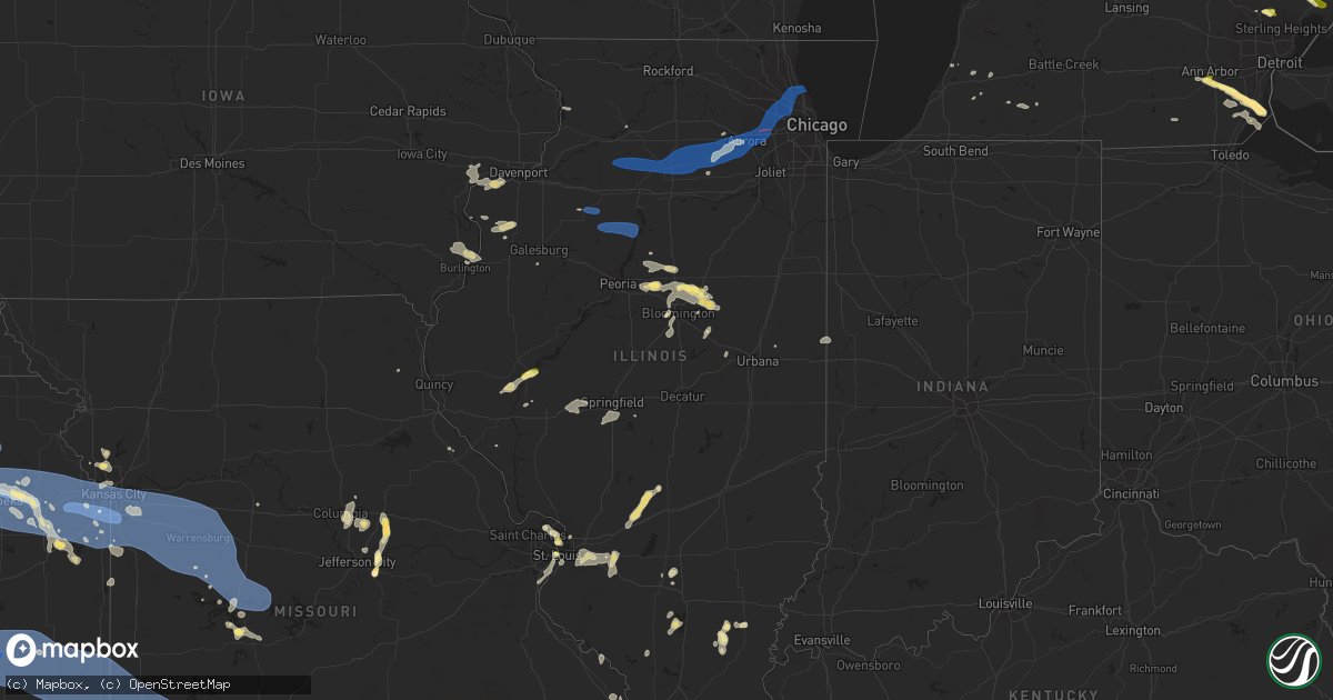
Hail Map in Illinois on July 14, 2023
Get this storm
July 14 map
$229
one time, instant access
Download today. No call, no setup
Keep the $229
Bought the map and want the full workflow? Apply the entire $229 to a subscription within 7 days. None of it is wasted.
Every map, not just this one
This buys you this map. Subscription and you get every map we run, in the markets you choose from a few cities to whole states to nationwide. Plus real-time alerts the moment a storm fires.
Contact data
Name, contact info, occupancy, even credit band for addresses in the footprint. You go from where it hit to who to call.
Become the source they trust
Unlimited branding weather history reports on demand. You already have the documented answer ready for the property owner, and you are the one who showed up with it.
Property data and RoofTrace estimates
Pull up any address you have got, its value and the exact code rules for that jurisdiction, straight from One Click Code. Then RoofTrace estimates the squares, pitch, and roof value, priced the way you price.
Storm reports in Illinois
Illinois
| Date | Description |
|---|---|
| 07/14/20235:10 PM CDT | Report from mping: quarter |
| 07/14/202311:16 AM CDT | Em reports multiple trees down around town. One large tree fell into home... Partially destroying it. |
| 07/13/202311:16 PM CDT | Corrects previous tstm wnd dmg report from worden. Previous time read 1116 am when should have been 1116 pm. Em reports multiple trees down around town. One large tree |
| 07/13/202310:20 PM CDT | Tree uprooted out of ground near fairview and ogden in downers grove. |
| 07/13/202310:01 PM CDT | Large tree landed on car in west side of aurora off orchard road. |
| 07/13/20239:57 PM CDT | Large branches downed. |
| 07/13/20239:42 PM CDT | Power lines down at maplewood and belden. |
| 07/13/20239:40 PM CDT | Large tree branch down on car 1800 s damen... Person was briefly trapped in the car. |
| 07/13/20239:40 PM CDT | Lots of large branches down... Some on homes. Trees and powerlines also reported down. Relayed via social media. |
| 07/13/20239:40 PM CDT | Large limb down on a couple of cars at 1441 n california. |
| 07/13/20239:29 PM CDT | 30 foot long limbs and many smaller-diameter branches down in the vicinity. |
| 07/13/20239:29 PM CDT | 30 foot long limbs and many other smaller diameter limbs down. |
| 07/13/20239:27 PM CDT | A local report indicates 70 MPH wind near Schaumburg |
| 07/13/20239:26 PM CDT | Multiple large tree limbs downed across the east side of schaumburg. Time estimated from radar. |
| 07/13/20239:25 PM CDT | An nws storm survey confirmed that widespread tree damage across elk grove village was caused by strong straight-line winds. Damage was most severe and concentrated in |
| 07/13/20239:25 PM CDT | Cocorahs observer reported 60-70 mph winds. |
| 07/13/20239:25 PM CDT | Pictures on social media shared of numerous large trees snapped and downed in the vicinity. One tree 2 feet in diameter. |
| 07/13/20239:20 PM CDT | Numerous medium sized tree branches down in roselle at corner of may street and arthur avenue. Power is also out on the west side of may street. Relayed via spotter net |
| 07/13/20239:20 PM CDT | Trees and power lines downed in bartlett. Time estimated from radar. |
| 07/13/20239:18 PM CDT | Estimates 65 to 70 mph wind gusts. |
| 07/13/20239:10 PM CDT | Corrects time of previous tstm wnd dmg report from 1 ne downers grove. Tree uprooted out of ground near fairview and ogden in downers grove. |
| 07/13/20239:07 PM CDT | Numerous 6 inch diameter branches down. Reported via social media. |
| 07/13/20239:07 PM CDT | Small pine tree uprooted. Time estimated from radar. |
| 07/13/20239:06 PM CDT | Via facebook with picture included: medium sized branch fallen from tree. |
| 07/13/20239:06 PM CDT | Numerous limbs and branches down in the vicinity... Some blocking roadways. |
| 07/13/20239:04 PM CDT | Radar indicated damage. |
| 07/13/20239:02 PM CDT | Multiple 3 inch diameter tree limbs downed. Time estimated from radar. |
| 07/13/20239:01 PM CDT | 6 inch diameter branch down at wehrli and lisson roads. |
| 07/13/20239:01 PM CDT | 4 inch diameter tree limb downed on west st. Time estimated. |
| 07/13/20239:00 PM CDT | Personal weather station measured a wind gust to 87 mph. |
| 07/13/20238:58 PM CDT | An nws damage survey determined an ef-0 tornado with estimated peak winds of 75 mph... Path width of 400 yards... And path length of 8.8 miles started near fermilab and |
| 07/13/20238:57 PM CDT | Fallen one foot diameter tree limb took out three power poles on n van buren and spring street. |
| 07/13/20238:56 PM CDT | Numerous 6 inch diameter branches and limbs down all over the area... Particularly between mckee and fabyan parkway... East towards route 31. |
| 07/13/20238:52 PM CDT | Measured at kilbatav3. |
| 07/13/20238:45 PM CDT | Corrects time of previous tstm wnd dmg report from 3 sw north aurora. Large tree landed on car in west side of aurora off orchard road. |
| 07/13/20238:42 PM CDT | Measured gust to 61 mph at arr asos. |
| 07/13/20238:39 PM CDT | Personal weather station measured a wind gust to 64 mph. |
| 07/13/20238:16 PM CDT | Limbs down on power lines. 2 trees down on a house in southeast mcleansboro. |
| 07/13/20237:54 PM CDT | Reports of a large tree downed onto a property north of triumph. |
| 07/13/20237:45 PM CDT | Trees downed. |
| 07/13/20237:40 PM CDT | Several trees blown down or snapped off at the base. Also... Power pole snapped off. This was in wilson park area. |
| 07/13/20237:35 PM CDT | Large tree down on the 700 block of dry gulch road. Was blocking three quarters of the roadway. Time estimated based on radar. |
| 07/13/20237:28 PM CDT | Multiple trees down in the neighbors yard... With estimated wind gusts to 60mph. |
| 07/13/20237:25 PM CDT | Powerlines down with one power pole snapped. Time estimated by radar. |
| 07/13/20237:15 PM CDT | 6 inch diameter tree branches down. |
| 07/13/20237:03 PM CDT | Large tree branch broken off near the base. |
| 07/13/20237:00 PM CDT | Two large tree limbs blown down and a porch roof collapsed. Relayed through social media. |
All States Impacted by Hail Map on July 14, 2023
Cities Impacted by Hail Map on July 14, 2023
- West Alexander, PA
- Valley Grove, WV
- Claysville, PA
- Avella, PA
- Washington, PA
- Lebanon, PA
- Myerstown, PA
- Marshalltown, IA
- Albion, IA
- Gilman, IA
- Ferguson, IA
- Grinnell, IA
- Kellogg, IA
- Roland, OK
- Muldrow, OK
- Van Buren, AR
- Fort Smith, AR
- Arkoma, OK
- Greenwood, AR
- Lavaca, AR
- Barling, AR
- Huntington, AR
- Hackett, AR
- Mansfield, AR
- Hartford, AR
- Waldron, AR
- Booneville, AR
- Clayton, NM
- Dalhart, TX
- Felt, OK
- Texline, TX
- Hartley, TX
- Skellytown, TX
- Borger, TX
- Pampa, TX
- Charleston, AR
- Alma, AR
- Magazine, AR
- Branch, AR
- Mullen, NE
- Tryon, NE
- North Platte, NE
- Stapleton, NE
- Maxwell, NE
- Brady, NE
- Keystone, NE
- Paxton, NE
- Sutherland, NE
- Hershey, NE
- Gothenburg, NE
- Callaway, NE
- Whitman, NE
- Maywood, NE
- Curtis, NE
- Hayes Center, NE
- McCook, NE
- Cambridge, NE
- Eustis, NE
- Stockville, NE
- Moorefield, NE
- Holbrook, NE
- Arapahoe, NE
- Bartley, NE
- Indianola, NE
- Hendley, NE
- Stamford, NE
- Norton, KS
- Edison, NE
- Beaver City, NE
- Wilsonville, NE
- Lebanon, NE
- Almena, KS
- Oxford, NE
- Long Island, KS
- Prairie View, KS
- Phillipsburg, KS
- Plainville, KS
- Ellis, KS
- Glade, KS
- Hays, KS
- Victoria, KS
- Walker, KS
- Franklin, WV
- Hill City, KS
- Penokee, KS
- Barnes, KS
- Waterville, KS
- Randolph, KS
- Olsburg, KS
- Blue Rapids, KS
- Westmoreland, KS
- Abbeville, MS
- Oxford, MS
- Thaxton, MS
- Etta, MS
- Ecru, MS
- Pontotoc, MS
- New Albany, MS
- Wakeeney, KS
- Ogallah, KS
- Hoxie, KS
- Morland, KS
- Palco, KS
- Manhattan, KS
- Saint George, KS
- Wamego, KS
- Onaga, KS
- Kirwin, KS
- Alton, KS
- Woodston, KS
- Gaylord, KS
- Stockton, KS
- Portis, KS
- Osborne, KS
- Cedar, KS
- Agra, KS
- Blue Springs, MS
- La Crosse, KS
- Schoenchen, KS
- Pfeifer, KS
- Bison, KS
- Lexington, NE
- Haddam, KS
- Big Springs, WV
- Grantsville, WV
- Scandia, KS
- Wallace, NE
- Elsie, NE
- Frankfort, KS
- Republic, KS
- Birch Tree, MO
- Alma, NE
- Orleans, NE
- Mahopac, NY
- Arthur, NE
- Bogue, KS
- Damar, KS
- Clifton, KS
- Clyde, KS
- Cutler, OH
- Webber, KS
- Courtland, KS
- Superior, NE
- Hardy, NE
- Gorham, KS
- Dickens, NE
- Ogallala, NE
- Russell, KS
- Belleville, WV
- Washington, WV
- Coolville, OH
- Lewellen, NE
- Norcatur, KS
- Palmer, KS
- Linn, KS
- Saint Louis, MO
- East Carondelet, IL
- Oberlin, KS
- Danbury, NE
- Farmington, CT
- Bristol, CT
- Plainville, CT
- Wolcott, CT
- Unionville, CT
- Kensington, KS
- Morrowville, KS
- Sylvan Grove, KS
- Kewadin, MI
- Belleville, KS
- Concordia, KS
- Guysville, OH
- Mineral Wells, WV
- Little Hocking, OH
- Parkersburg, WV
- Greenleaf, KS
- Sarah, MS
- Elwood, NE
- Wellfleet, NE
- Doniphan, MO
- Alton, MO
- Walker, WV
- Petroleum, WV
- Bertrand, NE
- Black Oak, AR
- Mammoth Spring, AR
- Dresden, KS
- Selden, KS
- Republican City, NE
- Natoma, KS
- Rison, AR
- Guide Rock, NE
- Logan, KS
- Farnam, NE
- Reedsville, OH
- Athens, OH
- Green, KS
- Lenora, KS
- Osceola, AR
- Etowah, AR
- Randolph, MS
- Myrtle, MS
- West Plains, MO
- Paxico, KS
- Belvue, KS
- Alma, KS
- Maple Hill, KS
- Capon Bridge, WV
- Gore, VA
- Cross Junction, VA
- Kanopolis, KS
- Ellsworth, KS
- Wilson, KS
- Lorraine, KS
- Beverly, KS
- Lincoln, KS
- Olmitz, KS
- Hoisington, KS
- Great Bend, KS
- St John, KS
- Albert, KS
- Otis, KS
- Hudson, KS
- Ellinwood, KS
- Winchester, VA
- Auburn, KS
- Harveyville, KS
- Topeka, KS
- Soldier, KS
- Holton, KS
- Havensville, KS
- Mayetta, KS
- Delia, KS
- Circleville, KS
- Saint Marys, KS
- Emmett, KS
- Spruce Creek, PA
- Pennsylvania Furnace, PA
- Claflin, KS
- Holyrood, KS
- Bushton, KS
- Chase, KS
- Raymond, KS
- Lyons, KS
- Geneseo, KS
- Little River, KS
- Alden, KS
- Sterling, KS
- Sylvia, KS
- Brookville, KS
- Silver Lake, KS
- Rossville, KS
- Overbrook, KS
- Wakarusa, KS
- Carbondale, KS
- Berryton, KS
- Tecumseh, KS
- Lecompton, KS
- Perry, KS
- Grantville, KS
- Lawrence, KS
- Otisville, MI
- Otter Lake, MI
- Millington, MI
- Sandusky, MI
- Carsonville, MI
- Deckerville, MI
- Port Sanilac, MI
- Hoyt, KS
- Valley Falls, KS
- Meriden, KS
- Ozawkie, KS
- Oskaloosa, KS
- McLouth, KS
- Winchester, KS
- Abbyville, KS
- Nickerson, KS
- Hutchinson, KS
- Partridge, KS
- Plevna, KS
- Mcpherson, KS
- Windom, KS
- Inman, KS
- Lindsborg, KS
- Salina, KS
- Gypsum, KS
- Assaria, KS
- Abilene, KS
- Saline, MI
- Ann Arbor, MI
- Baldwin City, KS
- Tonganoxie, KS
- Rochester, MI
- Auburn Hills, MI
- Ypsilanti, MI
- Milan, MI
- Willis, MI
- Belleville, MI
- Eskridge, KS
- Linwood, KS
- Easton, KS
- Lansing, KS
- Bonner Springs, KS
- Leavenworth, KS
- Eudora, KS
- Basehor, KS
- Gardner, KS
- Shawnee, KS
- Kansas City, KS
- New Century, KS
- De Soto, KS
- Lenexa, KS
- Edgerton, KS
- Olathe, KS
- Burrton, KS
- Buhler, KS
- Halstead, KS
- Hesston, KS
- Galva, KS
- Moundridge, KS
- Newton, KS
- Sedgwick, KS
- Bentley, KS
- Turon, KS
- Arlington, KS
- New Boston, MI
- Carleton, MI
- Utica, MI
- Redwood Falls, MN
- Morton, MN
- Franklin, MN
- Morgan, MN
- Glenrock, WY
- Wellsville, KS
- Spring Hill, KS
- Prairie Village, KS
- Stilwell, KS
- Leawood, KS
- Paola, KS
- Overland Park, KS
- Mission, KS
- Bucyrus, KS
- Kansas City, MO
- Marquette, KS
- Falun, KS
- Lehigh, KS
- Canton, KS
- Durham, KS
- Roxbury, KS
- Tampa, KS
- Hillsboro, KS
- Marion, KS
- Hope, KS
- Ramona, KS
- Lincolnville, KS
- Lost Springs, KS
- Goessel, KS
- Peabody, KS
- North Newton, KS
- Walton, KS
- Whitewater, KS
- Greenwich, KS
- Wichita, KS
- Valley Center, KS
- Benton, KS
- Kechi, KS
- Towanda, KS
- El Dorado, KS
- Elbing, KS
- Andover, KS
- Burns, KS
- Potwin, KS
- Pretty Prairie, KS
- Haven, KS
- Newport, MI
- South Rockwood, MI
- Louisburg, KS
- Belton, MO
- Grandview, MO
- Cleveland, MO
- Peculiar, MO
- Raymore, MO
- Lees Summit, MO
- Independence, MO
- Oak Grove, MO
- Riverside, MO
- Sibley, MO
- Buckner, MO
- Greenwood, MO
- Grain Valley, MO
- Blue Springs, MO
- Napoleon, MO
- Pleasant Hill, MO
- Florence, KS
- Cassoday, KS
- Leon, KS
- Rosalia, KS
- Eureka, KS
- Augusta, KS
- Hamilton, KS
- Mount Hope, KS
- Cheney, KS
- Garden Plain, KS
- Goddard, KS
- Andale, KS
- Jay Em, WY
- Lake Harmony, PA
- White Haven, PA
- Blakeslee, PA
- Monmouth, IA
- Baldwin, IA
- Lost Nation, IA
- Viola, KS
- Colwich, KS
- Clearwater, KS
- Peck, KS
- Haysville, KS
- Virgil, KS
- Toronto, KS
- Neal, KS
- Yates Center, KS
- Gridley, KS
- Bates City, MO
- Lone Jack, MO
- Harrisonville, MO
- Strasburg, MO
- Odessa, MO
- East Lynne, MO
- Leeton, MO
- Holden, MO
- Centerview, MO
- Warrensburg, MO
- Chilhowee, MO
- Wellington, MO
- Kingsville, MO
- Garden City, MO
- Mayview, MO
- Higginsville, MO
- North Street, MI
- Smiths Creek, MI
- Port Huron, MI
- Reston, VA
- Sterling, VA
- Vienna, VA
- Ashburn, VA
- Chantilly, VA
- Herndon, VA
- Fairfax, VA
- Oakton, VA
- Maquoketa, IA
- Delmar, IA
- Wellington, KS
- Derby, KS
- Belle Plaine, KS
- Mayfield, KS
- Mulvane, KS
- Oxford, KS
- Udall, KS
- Fredonia, KS
- Fall River, KS
- Severy, KS
- Blairstown, MO
- Creighton, MO
- Urich, MO
- Clinton, MO
- Linwood, MI
- New Haven, MI
- Richmond, MI
- Casco, MI
- East China, MI
- Glenwood City, WI
- Downing, WI
- Boyceville, WI
- Knapp, WI
- Cadott, WI
- Chippewa Falls, WI
- Windsor, MO
- Calhoun, MO
- Knob Noster, MO
- Concordia, MO
- Whiteman Air Force Base, MO
- Frederick, IL
- Beardstown, IL
- South Haven, KS
- Arkansas City, KS
- Geuda Springs, KS
- Winfield, KS
- La Monte, MO
- Warsaw, MO
- Lincoln, MO
- Green Ridge, MO
- Sweet Springs, MO
- Chanute, KS
- Benedict, KS
- Buffalo, KS
- Galesburg, KS
- Erie, KS
- Piqua, KS
- Humboldt, KS
- Savonburg, KS
- Colony, KS
- Le Roy, KS
- Iola, KS
- Neosho Falls, KS
- Menomonie, WI
- Colfax, WI
- Wheeler, WI
- Saint Paul, KS
- Elsmore, KS
- La Harpe, KS
- Moran, KS
- Stark, KS
- Walnut, KS
- Ionia, MO
- Cole Camp, MO
- Arlington, VA
- Fort Myer, VA
- Washington, DC
- Medford, OK
- Caldwell, KS
- May, OK
- Laverne, OK
- Buffalo, OK
- Braman, OK
- Newkirk, OK
- Ponca City, OK
- Maple City, KS
- Burden, KS
- Dexter, KS
- Nardin, OK
- Blackwell, OK
- Edwards, MO
- Sedalia, MO
- Stover, MO
- Uniontown, KS
- Hepler, KS
- Girard, KS
- Pittsburg, KS
- Farlington, KS
- McCune, KS
- Frontenac, KS
- Garland, KS
- Arma, KS
- Franklin, KS
- Bronson, KS
- Arcadia, KS
- Fort Scott, KS
- Mulberry, KS
- Redfield, KS
- Wheatland, MO
- Boyd, WI
- Stanley, WI
- Augusta, WI
- Thorp, WI
- Greenwood, WI
- Jefferson City, MO
- Loose Creek, MO
- Bonnots Mill, MO
- Cross Timbers, MO
- Kaw City, OK
- Shidler, OK
- Fargo, OK
- Willard, WI
- Loyal, WI
- Tebbetts, MO
- Arapahoe, WY
- Riverton, WY
- Cherokee, KS
- Carl Junction, MO
- Galena, KS
- Weir, KS
- Scammon, KS
- Columbus, KS
- Mindenmines, MO
- Asbury, MO
- Liberal, MO
- Opolis, KS
- Lamar, MO
- Deerfield, MO
- Bronaugh, MO
- Moundville, MO
- Webb City, MO
- Oronogo, MO
- Carthage, MO
- Purcell, MO
- Alba, MO
- Jasper, MO
- Neck City, MO
- Golden City, MO
- Sheldon, MO
- Fort Supply, OK
- Mills, NM
- Springer, NM
- Spencer, WI
- Unity, WI
- Joplin, MO
- Carterville, MO
- Lockwood, MO
- Lander, WY
- Jeffrey City, WY
- Fulton, MO
- Woodward, OK
- Reeds, MO
- Avilla, MO
- Sarcoxie, MO
- Miller, MO
- La Russell, MO
- Mount Vernon, MO
- Greenfield, MO
- South Greenfield, MO
- Ramona, OK
- Talala, OK
- Collinsville, OK
- Nowata, OK
- Mayville, MI
- Pinconning, MI
- Middleburgh, NY
- Avoca, MI
- Bentley, MI
- Rhodes, MI
- Hazleton, IA
- Independence, IA
- Henderson, KY
- Corydon, KY
- Robards, KY
- Green Isle, MN
- Raton, NM
- Clear Brook, VA
- Stephenson, VA
- Belle Plaine, MN
- Kinnear, WY
- Caro, MI
- Kingston, MI
- Casper, WY
- Attica, KS
- Zenda, KS
- Medicine Lodge, KS
- Almont, MI
- Allenton, MI
- Madison, KS
- Deerton, MI
- Marquette, MI
- Quapaw, OK
- Island, KY
- Calhoun, KY
- Rumsey, KY
- Hartville, WY
- Vassar, MI
- Fostoria, MI
- Washburn, WI
- Henderson, MN
- Gaylord, MN
- Arlington, MN
- Martinsburg, WV
- Kearneysville, WV
- Inwood, WV
- Sanford, NC
- Rockingham, NC
- Fort Plain, NY
- Freeman, MO
- Evansville, WY
- Stafford, KS
- Fort Riley, KS
- Ogden, KS
- Junction City, KS
- Bowling Green, MO
- Lapeer, MI
- Ellsworth, NE
- Cunningham, KS
- Galivants Ferry, SC
- Aynor, SC
- Harpers Ferry, WV
- Bluemont, VA
- Round Hill, VA
- Glendo, WY
- Lamont, OK
- Enterprise, KS
- North Branch, MI
- Imlay City, MI
- Columbiaville, MI
- Attica, MI
- Mount Morris, MI
- Clio, MI
- Rushville, NE
- Lake Orion, MI
- Applegate, MI
- Conway Springs, KS
- Germantown, MD
- Poolesville, MD
- Mount Sterling, IL
- Versailles, IL
- Le Sueur, MN
- Le Center, MN
- McLeansboro, IL
- Enfield, IL
- Fairfax, MN
- Sleepy Eye, MN
- Houston, MS
- Silverwood, MI
- Clifford, MI
- Petersburg, PA
- Paradise, KS
- Gerrardstown, WV
- Bingham, NE
- Hawk Springs, WY
- Wheatland, WY
- Chugwater, WY
- Bee, VA
- Denver, IA
- Waverly, IA
- Romney, WV
- Bartlesville, OK
- Nashville, KS
- Cascade, IA
- Center Junction, IA
- Onslow, IA
- Wyoming, IA
- Monticello, IA
- Memphis, MI
- Yale, MI
- Capac, MI
- Goodells, MI
- Emmett, MI
- Milton, KS
- Danville, KS
- Argonia, KS
- Hazelton, KS
- Waldron, KS
- Cass City, MI
- Deford, MI
- Douglas, WY
- Hamilton, VA
- Purcellville, VA
- Leesburg, VA
- Cheraw, SC
- Bay City, MI
- Boyds, MD
- Solomon, KS
- Wabasso, MN
- Cherry Valley, NY
- Jordanville, NY
- Mill Creek, WV
- Alexandria, PA
- Marysville, MI
- Ryan, IA
- Manchester, IA
- Midland, NC
- Drexel, MO
- Amsterdam, MO
- La Cygne, KS
- Aldie, VA
- Middleburg, VA
- Nichols, SC
- Mullins, SC
- Aaronsburg, PA
- Huntingdon, PA
- University Park, PA
- Spring Mills, PA
- Rebersburg, PA
- State College, PA
- Millheim, PA
- Centre Hall, PA
- Boalsburg, PA
- Tyrone, PA
- Pine Grove Mills, PA
- Lemont, PA
- Coburn, PA
- Noxapater, MS
- Williamsport, PA
- Roanoke, VA
- Walnut Hill, IL
- Centralia, IL
- Bayfield, WI
- Centreville, VA
- Manassas, VA
- Chadron, NE
- Hay Springs, NE
- Atalissa, IA
- Moscow, IA
- Marlette, MI
- Sharon, KS
- Cogan Station, PA
- Walker, IA
- Coggon, IA
- Wood Lake, MN
- Echo, MN
- Belview, MN
- Hamilton, AL
- Guin, AL
- Milan, KS
- Norwich, KS
- Kiowa, KS
- Catharine, KS
- Great Falls, VA
- Millboro, VA
- Pine Ridge, SD
- Berryville, VA
- High View, WV
- Lick Creek, KY
- Mouthcard, KY
- New Richmond, WI
- Bellefonte, PA
- Dayton, VA
- Bridgewater, VA
- Charles Town, WV
- Plainfield, IA
- Shell Rock, IA
- Janesville, IA
- Clarksville, IA
- Amboy, MN
- Vernon Center, MN
- Mapleton, MN
- Berkeley Springs, WV
- Potomac, MD
- Gaithersburg, MD
- Rockville, MD
- Jackson, MO
- Bernard, IA
- Kingman, KS
- Kawkawlin, MI
- Midland, MI
- Rapid River, MI
- Lebanon, IL
- O'Fallon, IL
- Hacker Valley, WV
- Pickens, WV
- De Kalb, MS
- Fork, SC
- Wilton, IA
- Edgerton, MO
- Smithville, MO
- Platte City, MO
- Birchleaf, VA
- Haysi, VA
- Pawhuska, OK
- Bruce, MS
- Houlka, MS
- Banner, MS
- Masonville, IA
- Winthrop, IA
- Gresham, SC
- Lowden, IA
- Lexington, MI
- Decker, MI
- Snover, MI
- Croswell, MI
- Barnsdall, OK
- Skiatook, OK
- Augusta, WV
- Yellow Spring, WV
- Stephens City, VA
- Fairfax Station, VA
- Clifton, VA
- Shanks, WV
- McCracken, KS
- Armada, MI
- Bunker Hill, WV
- Great Cacapon, WV
- Paw Paw, WV
- Oak Ridge, MO
- Altenburg, MO
- Ochelata, OK
- Dewey, OK
- Bunker Hill, KS
- Hamlet, NC
- Hopkinton, IA
- Garrett, WY
- Murdock, KS
- Bluff City, KS
- Frankford, MO
- Cheyenne, WY
- Ottawa, KS
- Dryden, MI
- Bristol, VA
- Paris, MS
- Laurel Hill, NC
- Berwind, WV
- Boyce, VA
- Marion, NC
- Peck, MI
- Munising, MI
- Muscatine, IA
- Clinchco, VA
- Dante, VA
- Oologah, OK
- Granite City, IL
- Sublette, IL
- La Moille, IL
- Mendota, IL
- Earlville, IL
- Ohio, IL
- Amboy, IL
- Harmon, IL
- Walnut, IL
- Van Orin, IL
- Deer Grove, IL
- Triumph, IL
- Bradford, IL
- Wyoming, IL
- Henry, IL
- Sparland, IL
- Kewanee, IL
- Toulon, IL
- Neponset, IL
- Paw Paw, IL
- Compton, IL
- Fairview, OK
- Sharon, OK
- Diamond, MO
- Duenweg, MO
- Neosho, MO
- Powell, MO
- Rocky Comfort, MO
- Stella, MO
- Stark City, MO
- Goodman, MO
- Granby, MO
- Verona, MO
- Stotts City, MO
- Exeter, MO
- Purdy, MO
- Butterfield, MO
- Pierce City, MO
- Aurora, MO
- Wentworth, MO
- Freistatt, MO
- Fairview, MO
- Monett, MO
- Cassville, MO
- Wheaton, MO
- Ash Grove, MO
- Crane, MO
- Everton, MO
- Marionville, MO
- Billings, MO
- Anderson, MO
- Seligman, MO
- Washburn, MO
- Branson, MO
- Blue Eye, MO
- Cape Fair, MO
- Hollister, MO
- Shell Knob, MO
- Ridgedale, MO
- Golden, MO
- Galena, MO
- Reeds Spring, MO
- Kimberling City, MO
- Eagle Rock, MO
- Lampe, MO
- Leland, IL
- Sheridan, IL
- Sandwich, IL
- Waterman, IL
- Somonauk, IL
- Hinckley, IL
- Shabbona, IL
- Kirbyville, MO
- Omaha, AR
- Oak Grove, AR
- Mutual, OK
- Vici, OK
- Newark, IL
- Millbrook, IL
- Yorkville, IL
- Big Rock, IL
- Plano, IL
- Wagoner, OK
- Sugar Grove, IL
- Aurora, IL
- Bristol, IL
- Cedarcreek, MO
- Lead Hill, AR
- Camargo, OK
- Montgomery, IL
- Oswego, IL
- Warrenville, IL
- North Aurora, IL
- Naperville, IL
- Batavia, IL
- Wheaton, IL
- Glen Ellyn, IL
- Lisle, IL
- Winfield, IL
- West Chicago, IL
- Taloga, OK
- Eureka, IL
- Congerville, IL
- Bella Vista, AR
- Pineville, MO
- Noel, MO
- Cave Springs, AR
- Bentonville, AR
- Fayetteville, AR
- Prairie Grove, AR
- Lincoln, AR
- Farmington, AR
- Springdale, AR
- Gentry, AR
- Rogers, AR
- Garfield, AR
- Lowell, AR
- Pea Ridge, AR
- Gravette, AR
- Siloam Springs, AR
- Decatur, AR
- Hiwasse, AR
- Centerton, AR
- Summers, AR
- Sulphur Springs, AR
- West Fork, AR
- Eureka Springs, AR
- Thornfield, MO
- Peel, AR
- Protem, MO
- Kissee Mills, MO
- Yellville, AR
- Theodosia, MO
- Winslow, AR
- Rueter, MO
- Bradleyville, MO
- Powersite, MO
- Braggs, OK
- Muskogee, OK
- Isabella, MO
- Gore, OK
- Putnam, OK
- Maxwell, NM
- Schaumburg, IL
- Roselle, IL
- Bloomingdale, IL
- Carol Stream, IL
- Elk Grove Village, IL
- Glendale Heights, IL
- Medinah, IL
- Itasca, IL
- Hanover Park, IL
- Lombard, IL
- Addison, IL
- Villa Park, IL
- Bensenville, IL
- Elmhurst, IL
- Franklin Park, IL
- Wood Dale, IL
- Rolling Meadows, IL
- Des Plaines, IL
- Arlington Heights, IL
- Mount Prospect, IL
- Prospect Heights, IL
- Wheeling, IL
- Park Ridge, IL
- Glenview, IL
- Northbrook, IL
- Schiller Park, IL
- Lexington, IL
- Gridley, IL
- Hudson, IL
- El Paso, IL
- Evansville, AR
- Morrow, AR
- Natural Dam, AR
- Stilwell, OK
- Canehill, AR
- Rudy, AR
- Cedarville, AR
- Uniontown, AR
- Chester, AR
- Pontiac, MO
- Gainesville, MO
- Niles, IL
- Glencoe, IL
- Winnetka, IL
- Deerfield, IL
- Highland Park, IL
- Thomas, OK
- Weatherford, OK
- Geary, OK
- Berryville, AR
- Alpena, AR
- Jasper, AR
- Green Forest, AR
- Harrison, AR
- Compton, AR
- Marble Falls, AR
- Hasty, AR
- Vendor, AR
- Pelsor, AR
- Leslie, AR
- Clinton, AR
- Center Ridge, AR
- Tilly, AR
- Jerusalem, AR
- Scotland, AR
- Marshall, AR
- Cleveland, AR
- Western Grove, AR
- Saint Joe, AR
- Hector, AR
- Mount Judea, AR
- Witts Springs, AR
- Dennard, AR
- Everton, AR
- Gilbert, AR
- Pindall, AR
- Deer, AR
- Hydro, OK
- Bee Branch, AR
- Cimarron, NM
- Russellville, AR
- Dover, AR
- Atkins, AR
- Springfield, AR
- Solgohachia, AR
- Hattieville, AR
- Morrilton, AR
- Mount Vernon, AR
- Greenbrier, AR
- Enola, AR
- Choctaw, AR
- Damascus, AR
- Quitman, AR
- Guy, AR
- Fairfield Bay, AR
- Higden, AR
- Shirley, AR
- Fox, AR
- Edgemont, AR
- Pottsville, AR
- Plumerville, AR
- New Berlin, NY
- Edmeston, NY
- Garrattsville, NY
- Burlington Flats, NY
- West Burlington, NY
- Hartwick, NY
- West Winfield, NY
- Richfield Springs, NY
- Conway, AR
- Wooster, AR
- Vilonia, AR
- Mohawk, NY
- Pocono Lake, PA
- Rice Lake, WI
- Mikana, WI
- Birchwood, WI
- Little Falls, NY
- Little Rock, AR
- North Little Rock, AR
- Scott, AR
- England, AR
- Keo, AR
- Hensley, AR
- Redfield, AR
- Jefferson, AR
- Sheridan, AR
- White Hall, AR
- South New Berlin, NY
- Saint Johnsville, NY
- Pine Bluff, AR
- Grady, AR
- Star City, AR
- Yorktown, AR
- Tucumcari, NM
- Wilmar, AR
- Dumas, AR
- Gould, AR
- East Saint Louis, IL
- Burlington, IA
- Andover, NJ
- Stanhope, NJ
- Deer Park, WI
- Edna, KS
- Weyerhaeuser, WI
- Bruce, WI
- Little York, IL
- New Bloomfield, MO
- Holts Summit, MO
- Cornucopia, WI
- Dixon, IL
- Aurora, IA
- Gladstone, IL
- Herbster, WI
- Angola, IN
- Baldwin, WI
- Shoshoni, WY
- Colfax, IL
- Cooksville, IL
- Clifton Forge, VA
- Alcova, WY
- West Branch, MI
- Coldwater, KS
- Protection, KS
- Elkville, IL
- Murphysboro, IL
- Vergennes, IL
- Lamar, AR
- Clarksville, AR
- Welch, OK
- Mokane, MO
- Mulberry Grove, IL
- Greenville, IL
- Fillmore, IL
- Coffeen, IL
- Newfoundland, NJ
- West Milford, NJ
- Butler, NJ
- Briggsdale, CO
- Hermitage, MO
- Preston, MO
- Quincy, MO
- East Stroudsburg, PA
- Columbia, NJ
- Delaware Water Gap, PA
- Stroudsburg, PA
- Columbia, MO
- Hallsville, MO
- Seaton, IL
- Aledo, IL
- Viola, IL
- Alexis, IL
- Leakesville, MS
- Grand Mound, IA
- Wheatland, IA
- Calamus, IA
- De Witt, IA
- Fairview Heights, IL
- Belleville, IL
- London, AR
- Maybee, MI
- Chelsea, OK
- Claremore, OK
- Illinois City, IL
- Taylor Ridge, IL
- Preston, IA
- Marion, SC
- Marshall, MO
- Alva, OK
- Bushnell, NE
- Pine Bluffs, WY
- Carpenter, WY
- Wetmore, MI
- Rye, NY
- Lagrange, WY
- Montoursville, PA
- Trout Run, PA
- Martelle, IA
- Anamosa, IA
- New Boston, IL
- Joy, IL
- Ewing, MO
- Lewistown, MO
- Aline, OK
- Newton, NJ
- Winnebago, MN
- Granada, MN
- Truman, MN
- Bloomer, WI
- Freedom, OK
- Macedonia, IL
- Perryville, MO
- Collinsville, IL
- Scott Air Force Base, IL
- Troy, IL
- Albers, IL
- Aviston, IL
- Mascoutah, IL
- Caseyville, IL
- Trenton, IL
- Summerfield, IL
- New Baden, IL
- Germantown, IL
- Marshfield, WI
- Florissant, MO
- Kingdom City, MO
- Cedar Vale, KS
- Ault, CO
- Lowpoint, IL
- Metamora, IL
- Washburn, IL
- Benson, IL
- Minonk, IL
- Roanoke, IL
- Concord, NC
- Pocahontas, IL
- Bingham, IL
- Ramsey, IL
- Drew, MS
- Parchman, MS
- Tutwiler, MS
- Bethesda, MD
- Sussex, NJ
- Seiling, OK
- Hudson, IN
- Gladstone, NM
- Cleveland, OK
- Bennett, IA
- Donahue, IA
- Dixon, IA
- Spragueville, IA
- Long Grove, IA
- Oxford Junction, IA
- Isabella, OK
- Okeene, OK
- Blue Grass, IA
- Davenport, IA
- Hawley, PA
- Middlebrook, VA
- Raphine, VA
- Durham, CT
- Middlefield, CT
- Baxter Springs, KS
- Seneca, MO
- Mendon, MI
- Three Rivers, MI
- Benton, IL
- Sesser, IL
- Arnett, OK
- Schroon Lake, NY
- Waterloo, IN
- Butler, IN
- Chester, OK
- Mooreland, OK
- Custer City, OK
- Rockaway, NJ
- Hibernia, NJ
- Serena, IL
- Sarona, WI
- Burbank, OK
- Monroe, MI
- Minneola, KS
- Wesley, AR
- Elkins, AR
- Cooperstown, NY
- Nebo, IL
- Hayward, WI
- Galesburg, IL
- Elburn, IL
- Edwardsville, IL
- Carmel, NY
- Yorktown Heights, NY
- Granite Springs, NY
- Jefferson Valley, NY
- Somers, NY
- Baldwin Place, NY
- Manchester, PA
- York, PA
- Dale, IL
- Bluffs, IL
- Tripoli, IA
- Sperry, IA
- Mediapolis, IA
- Keosauqua, IA
- Lexington, VA
- Lake Pleasant, NY
- Lagrange, IN
- Wilmore, KS
- Lamont, IA
- Oelwein, IA
- Fayette, IA
- Stanley, IA
- Delavan, MN
- Blue Earth, MN
- Easton, MN
- Fay, OK
- Ringwood, OK
- Centertown, KY
- Vinita, OK
- Broughton, IL
- Ozark, AR
- Bangor, PA
- Pen Argyl, PA
- Nazareth, PA
- Easton, PA
- Phillipsburg, NJ
- Fort Lawn, SC
- Chouteau, OK
- Inola, OK
- Pryor, OK
- Catoosa, OK
- Independence, KS
- Anoka, MN
- Elk River, MN
- Loganville, GA
- Pine Island, NY
- Westtown, NY
- Vernon, NJ
- Deer Creek, OK
- Anthony, KS
- Chesterfield, SC
- Ashland, KS
- Falls Church, VA
- McLean, VA
- Orland, IN
- Morrow, GA
- Mulkeytown, IL
- Tonkawa, OK
- Delhi, IA
- Clara City, MN
- Exeland, WI
- Good Thunder, MN
- Blairstown, NJ
- Ashley, IN
- Portland, PA
- Mount Bethel, PA
- Deer Creek, IL
- Goodfield, IL
- Washington, IL
- Adair, OK
- Towanda, IL
- Nunn, CO
- Grover, CO
- Arnold, MO
- Rock Springs, WI
- North Freedom, WI
- East Springfield, NY
- Ewen, MI
- Livermore, KY
- Buffalo, IA
- Deepwater, MO
- Marland, OK
- Red Rock, OK
- Montpelier, IA
- Andalusia, IL
- Berne, NY
- Burlington, CT
- Avoca, WI
- Lone Rock, WI
- Centralia, MO
- Dardanelle, AR
- Galatia, IL
- Eldorado, IL
- Raleigh, IL
- Scheller, IL
- Ponca, AR
- Parthenon, AR
- Spivey, KS
- Lake City, AR
- Arrowsmith, IL
- Secor, IL
- Carlock, IL
- Copan, OK
- Thomson, IL
- Fairbank, IA
- Oran, IA
- Peru, KS
- Hennessey, OK
- Pleasant Lake, IN
- Lackawaxen, PA
- Harper, KS
- Cleveland, NC
- Yarmouth, IA
- Mount Wolf, PA
- Ashland, MO
- Adrian, MI
- Deansboro, NY
- Madison, NY
- Bouckville, NY
- Oriskany Falls, NY
- Hamilton, NY
- Gilman, WI
- Far Hills, NJ
- Hamburg, NJ
- Saint Clair, MI
- Channing, TX
- Mcalister, NM
- Rankin, IL
- Woodward, PA
- Madisonburg, PA
- Hinton, OK
- Woodlawn, IL
- Mansfield, IL
- De Land, IL
- Hereford, TX
- McLean, IL
- Heyworth, IL
- Shirley, IL
- Lawrence, MI
- Mendham, NJ
- Morristown, NJ
- Howe, IN
- Denville, NJ
- Boonton, NJ
- Thomasboro, IL
- Urbana, IL
- Penfield, IL
- Ogden, IL
- Saint Joseph, IL
- Paw Paw, MI
- Edinburg, IL
- Rochester, IL
- Covert, MI
- Dowagiac, MI
- Decatur, MI
- Monticello, IL
- West Lebanon, IN
- Williamsport, IN
- Chenoa, IL
- Oakwood, OK
- Canadian, TX
- Saybrook, IL
- Anchor, IL
- Chapin, IL
- Bismarck, IL
- Veedersburg, IN
- Cassville, NY
- Waterville, NY
- Dover, NJ
- Warriors Mark, PA
- Stockland, IL
- Milford, IL
- Donnellson, IL
- Clements, MN
- Corn, OK
- Bloomington, IL
- Armstrong, IL
- Ashland, IL
- Alexander, IL
- Pleasant Plains, IL
- New Berlin, IL
- Loganton, PA
- Greeley, PA
- Osage, OK
- Springfield, IL
- Chatham, IL
- Glenarm, IL
- Le Roy, IL
- Alvin, IL
- Wildorado, TX
- Vega, TX
- Ellsworth, IL
- Stinnett, TX
- Auburn, IL
- Pawnee, IL
- Hartman, AR
- Jacksonville, IL
- Waltonville, IL
- Colony, OK
- Cordell, OK
- Normal, IL
- Clintonville, WI
- Bear Creek, WI
- Marcellus, MI
- Northport, MI
- Amarillo, TX
- Dix, IL
- Masterson, TX
- Mancelona, MI


