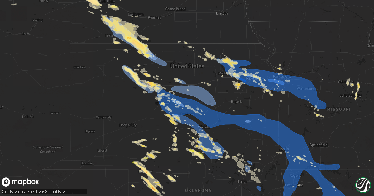
Hail Map in Kansas on July 14, 2023
Get this storm
July 14 map
$229
one time, instant access
Download today. No call, no setup
Keep the $229
Bought the map and want the full workflow? Apply the entire $229 to a subscription within 7 days. None of it is wasted.
Every map, not just this one
This buys you this map. Subscription and you get every map we run, in the markets you choose from a few cities to whole states to nationwide. Plus real-time alerts the moment a storm fires.
Contact data
Name, contact info, occupancy, even credit band for addresses in the footprint. You go from where it hit to who to call.
Become the source they trust
Unlimited branding weather history reports on demand. You already have the documented answer ready for the property owner, and you are the one who showed up with it.
Property data and RoofTrace estimates
Pull up any address you have got, its value and the exact code rules for that jurisdiction, straight from One Click Code. Then RoofTrace estimates the squares, pitch, and roof value, priced the way you price.
Storm reports in Kansas
Kansas
| Date | Description |
|---|---|
| 07/14/20236:39 PM CDT | The line has just worked in... We have winds right at 60 mph in central cherokee county. |
| 07/14/20236:36 PM CDT | Report from mping: 1-inch tree limbs broken; shingles blown off. Time based on radar. |
| 07/14/20236:32 PM CDT | Winds estimated 70 mph with damage and power outages. Time based on radar. |
| 07/14/20236:32 PM CDT | Several roadways are blocked by trees with many powerlines down. Time based on radar. |
| 07/14/20236:24 PM CDT | Reports of street flooding in town along with several trees and power lines down. |
| 07/14/20236:21 PM CDT | Report from mping: 1-inch tree limbs broken; shingles blown off. |
| 07/14/20236:20 PM CDT | Several large tree limbs down and transformers blown in girard. Unknown size other than large. Time based on radar. |
| 07/14/20236:13 PM CDT | A local report indicates 62 MPH wind near 1 N Maple City |
| 07/14/20236:10 PM CDT | Round bales moved in the wind and power lines down. Picture sent in email. Time based on radar. |
| 07/14/20236:05 PM CDT | Tree reported down in town. |
| 07/14/20236:05 PM CDT | Trees and powerlines down. Time estimated from radar. |
| 07/14/20236:05 PM CDT | Trees and powerlines down. Time estimated from radar. |
| 07/14/20235:57 PM CDT | Report of power lines down in erie. |
| 07/14/20235:55 PM CDT | Trees and powerlines down. Time estimated from radar. |
| 07/14/20235:52 PM CDT | Report from mping: trees uprooted or snapped; roof blown off. |
| 07/14/20235:45 PM CDT | Delayed report of trees down and the power out in the city. Time based on radar. |
| 07/14/20235:43 PM CDT | A local report indicates 70 MPH wind near Allen County Airport |
| 07/14/20235:39 PM CDT | A local report indicates 63 MPH wind near 7 N Arkansas City |
| 07/14/20235:36 PM CDT | Ks mesonet site reported an 85 mph wind gust. |
| 07/14/20235:32 PM CDT | A local report indicates 69 MPH wind near Chanute Airport |
| 07/14/20235:30 PM CDT | County dispatch reports... 60 to 70 mph winds. |
| 07/14/20235:27 PM CDT | A local report indicates 58 MPH wind near Chanute Airport |
| 07/14/20235:25 PM CDT | A local report indicates 70 MPH wind near Humboldt |
| 07/14/20235:08 PM CDT | Report of a semi trailer blown over on highway 54. Multiple power lines are reported down through the county. |
| 07/14/20234:57 PM CDT | Widespread 4 to 6 inch diameter tree limbs down in hamilton. Some limbs were 12 inches in diameter. |
| 07/14/20234:57 PM CDT | Widespread 4 to 6 inch tree limbs down. Some limbs were 12 inches in diameter. |
| 07/14/20234:57 PM CDT | 4 to 6 inch tree limbs and power lines down. |
| 07/14/20234:41 PM CDT | A local report indicates 65 MPH wind near 3 E Thrall |
| 07/14/20234:40 PM CDT | A local report indicates 60 MPH wind near 4 N Clearwater |
| 07/14/20234:20 PM CDT | Multiple reports of power lines and tree limbs down. |
| 07/14/20234:20 PM CDT | Report from mping: 1-inch tree limbs broken. |
| 07/14/20234:20 PM CDT | Report from mping: 3-inch tree limbs broken; power poles broken. |
| 07/14/20234:17 PM CDT | Delayed report of 4 inch diameter tree limbs down. Time estimated by radar. |
| 07/14/20234:15 PM CDT | Report from mping: 3-inch tree limbs broken; power poles broken. |
| 07/14/20234:14 PM CDT | Report from mping: 3-inch tree limbs broken; power poles broken. |
| 07/14/20234:14 PM CDT | Large tree snapped. |
| 07/14/20234:11 PM CDT | Report from mping: 3-inch tree limbs broken; power poles broken. |
| 07/14/20234:09 PM CDT | Report from mping: 1-inch tree limbs broken. |
| 07/14/20234:09 PM CDT | Trained spotter reported 60 mph gusts as well as localized street flooding. |
| 07/14/20234:07 PM CDT | Report from mping: 3-inch tree limbs broken; power poles broken. |
| 07/14/20234:05 PM CDT | Delayed report... Broadcast media tweet showing very large tree on house with significant roof damage. Time estimated from radar. |
| 07/14/20234:04 PM CDT | 21 inch diameter tree down at vine and maple. |
| 07/14/20234:03 PM CDT | Trained spotter estimated 75-80 mph winds. |
| 07/14/20234:00 PM CDT | A local report indicates 60 MPH wind near Burns |
| 07/14/20234:00 PM CDT | A local report indicates 60 MPH wind near Potwin |
| 07/14/20234:00 PM CDT | A local report indicates 65 MPH wind near 1 S Merriam |
| 07/14/20233:58 PM CDT | A local report indicates 60 MPH wind near 2 SSE Lenexa |
| 07/14/20233:57 PM CDT | Report from mping: 3-inch tree limbs broken; power poles broken. |
| 07/14/20233:56 PM CDT | Report from mping: 1-inch tree limbs broken. |
| 07/14/20233:55 PM CDT | Report from mping: 1-inch tree limbs broken. |
| 07/14/20233:55 PM CDT | Spotter reports 70 mph wind gusts for 20 minutes with a peak gust of 89 mph. Large tree limbs down and shingles blown off roof. |
| 07/14/20233:55 PM CDT | 6 inch tree branches downed. Time estimated from radar. |
| 07/14/20233:54 PM CDT | Large tree limbs downed on maplewood lane in lenexa. |
| 07/14/20233:53 PM CDT | Delayed report... Twitter picture of a personal weather station indicating 69.7 mph wind at 3:53 pm. |
| 07/14/20233:50 PM CDT | Report from mping: 1-inch tree limbs broken. |
| 07/14/20233:47 PM CDT | *** 1 inj *** numerous trees and powerlines down. A car was blown off us 59 into a creek and an injury resulted. |
| 07/14/20233:47 PM CDT | A local report indicates 68 MPH wind near 1 NNW Maywood |
| 07/14/20233:45 PM CDT | Report from mping: 1-inch tree limbs broken. |
| 07/14/20233:43 PM CDT | Delayed report... Tree down at 51st and quivira. |
| 07/14/20233:40 PM CDT | Delayed report of partial roof blown off at the municipal airport in marion. |
| 07/14/20233:40 PM CDT | Estimated 6 inch tree branches down at the marion county courthouse. |
| 07/14/20233:39 PM CDT | A local report indicates 70 MPH wind near 2 SW Lake Quivira |
| 07/14/20233:39 PM CDT | A local report indicates 1.00 inch wind near 1 SSE Wellsville |
| 07/14/20233:35 PM CDT | A local report indicates 67 MPH wind near Newton Airport |
| 07/14/20233:34 PM CDT | Delayed report... Several tree branches down in the area of 168th and evans road. |
| 07/14/20233:29 PM CDT | Heavy rain... Low visibility. |
| 07/14/20233:25 PM CDT | Tree downed into power lines in tonganoxie. |
| 07/14/20233:21 PM CDT | Corrects previous non-tstm wnd gst report from 5 nne lawrence. Asos station klwc lawrence. |
| 07/14/20233:20 PM CDT | Report from mping: 1-inch tree limbs broken; shingles blown off. |
| 07/14/20233:20 PM CDT | Klwc asos. |
| 07/14/20233:17 PM CDT | Delayed report... |
| 07/14/20233:16 PM CDT | Report from mping: 1-inch tree limbs broken; shingles blown off. |
| 07/14/20233:14 PM CDT | A local report indicates 60 MPH wind near 3 W Jarbalo |
| 07/14/20233:12 PM CDT | A local report indicates 1.75 inch wind near Eskridge |
| 07/14/20233:09 PM CDT | A local report indicates 70 MPH wind near Oskaloosa |
| 07/14/20233:08 PM CDT | Personal weather station. |
| 07/14/20233:08 PM CDT | Spotter estimated 50-60 mph wind gusts. |
| 07/14/20233:07 PM CDT | A local report indicates 1.00 inch wind near 4 WNW Lawrence |
| 07/14/20233:07 PM CDT | A local report indicates 70 MPH wind near 3 WNW Lawrence |
| 07/14/20233:01 PM CDT | Personal weather station. |
| 07/14/20233:00 PM CDT | Report from mping: 3-inch tree limbs broken; power poles broken. Time estimated from radar. |
| 07/14/20233:00 PM CDT | Also one foot diameter tree limbs down and quarter size hail. |
| 07/14/20233:00 PM CDT | Personal weather station. |
| 07/14/20232:59 PM CDT | A local report indicates 58 MPH wind near Hutchinson Airport |
| 07/14/20232:57 PM CDT | Report from mping: 3-inch tree limbs broken; power poles broken. Delayed report. |
| 07/14/20232:57 PM CDT | Up station. |
| 07/14/20232:57 PM CDT | A local report indicates 75 MPH wind near 1 W Oskaloosa |
| 07/14/20232:56 PM CDT | Kansas state mesonet. |
| 07/14/20232:54 PM CDT | Delayed report... By off duty nws employee of 6 inch diameter tree limbs down. |
| 07/14/20232:53 PM CDT | Kfoe asos. |
| 07/14/20232:52 PM CDT | Large tree looks like its been snapped in half. Report from social media. |
| 07/14/20232:52 PM CDT | Fire chief estimating 70 mph wind gust. |
| 07/14/20232:50 PM CDT | A local report indicates 65 MPH wind near 4 N Carbondale |
| 07/14/20232:45 PM CDT | Fire chief estimates 85 mph wind gust. Signs blown of posts and 0 visibility. |
| 07/14/20232:45 PM CDT | Kansas state mesonet. |
| 07/14/20232:41 PM CDT | Report from mping: 1-inch tree limbs broken; shingles blown off. |
| 07/14/20232:41 PM CDT | Power lines down... Significant damages to trees... Homes... Vehicles with many power lines down across perry. Time estimated from radar. |
| 07/14/20232:41 PM CDT | Multiple trees snapped in perry... One as large as 36 inches in diameter. |
| 07/14/20232:40 PM CDT | A local report indicates 60 MPH wind near 2 NE Lawrence |
| 07/14/20232:39 PM CDT | Personal weather station... Delayed report. |
| 07/14/20232:35 PM CDT | Personal weather station. |
| 07/14/20232:34 PM CDT | A local report indicates 60 MPH wind near Salina Municipal Airpor |
| 07/14/20232:31 PM CDT | Report from mping: 1-inch tree limbs broken; shingles blown off. |
| 07/14/20232:30 PM CDT | Personal station. |
| 07/14/20232:30 PM CDT | Many tree limbs around 3 inches in diameter down on road. |
| 07/14/20232:30 PM CDT | Estimated 8 inch tree limbs down. Time estimated from radar data. |
| 07/14/20232:30 PM CDT | Union and pacific station. |
| 07/14/20232:29 PM CDT | Ktop asos. |
| 07/14/20232:28 PM CDT | Kansas state mesonet. |
| 07/14/20232:28 PM CDT | Asos station ktop topeka. |
| 07/14/20232:25 PM CDT | 60-70 estimated. |
| 07/14/20232:24 PM CDT | Kansas state mesonet. |
| 07/14/20232:20 PM CDT | Estimated wind gusts to 60. |
| 07/14/20232:20 PM CDT | Estimated gusts 70-75 mph. |
| 07/14/20232:16 PM CDT | Spotter reports widespread tree damage in lyons. |
| 07/14/20232:16 PM CDT | Four inch diameter tree limbs broken along with a couple larger weaker trees. There are powerlines down as well leaving parts of the city with out power. Time is based |
| 07/14/20232:14 PM CDT | 60 to 70 mph winds. |
| 07/14/20232:14 PM CDT | A local report indicates 1.00 inch wind near 4 W Ellinwood |
| 07/14/20232:14 PM CDT | Estimated wind gusts of 70-80 mph... With large branches broken. |
| 07/14/20232:10 PM CDT | 55-65 estimated. |
| 07/14/20232:07 PM CDT | Personal weather station. |
| 07/14/20232:02 PM CDT | A local report indicates 60 MPH wind near Great Bend Airport |
| 07/14/20231:59 PM CDT | A local report indicates 60 MPH wind near Ellsworth |
| 07/14/20231:50 PM CDT | Significant tree damage as well as power outages in town. |
| 07/14/20231:50 PM CDT | Observer reported 65 to 70 mph winds and tree damage in town. Time is based on radar. |
| 07/14/20231:46 PM CDT | Wind estimated at 60 to 70 mph. Visibility was reduced to 200 yards. Report received through social media. |
| 07/14/20231:41 PM CDT | A local report indicates 62 MPH wind near 9 W Westfall |
| 07/14/20231:22 PM CDT | A local report indicates 60 MPH wind near 5 E Galatia |
| 07/14/20231:18 PM CDT | Wind gusts were estimated between 65 and 70 mph. Report was received through social media. |
| 07/14/20231:05 PM CDT | Public weather station reports gust of 62 mph. |
| 07/14/202312:55 PM CDT | Mesonet station up852 3.7 w ogallah |
| 07/14/202312:55 PM CDT | Mesonet station wkuk1 wakeeney. |
| 07/14/202312:40 PM CDT | Reports of tree damage in the alton area. |
| 07/14/202312:20 PM CDT | Time estimated from radar. This confirms another report of 75 mph in the area. 8 inch tree limbs downed and other tree damage also reported nearby. |
| 07/14/202312:18 PM CDT | Kirwin kansas raws automated weather observation. Time estimated from radar and other nearby reports. |
| 07/14/202312:15 PM CDT | A local report indicates 2.00 inch wind near Catherine |
| 07/14/202311:46 AM CDT | Report relayed via social media. Very strong winds also reported with the hail. Time estimated from radar. |
| 07/14/202311:45 AM CDT | Report from mping: quarter |
| 07/14/202311:45 AM CDT | A local report indicates 1.00 inch wind near 4 S Long Island |
| 07/14/202311:35 AM CDT | Delayed report on social media of estimated 60 to 70 mph wind gusts with storm passage. Time estimated from radar. |
| 07/14/202311:35 AM CDT | Facebook report of marble to quarter size hail. Timing estimated by radar. |
All States Impacted by Hail Map on July 14, 2023
Cities Impacted by Hail Map on July 14, 2023
- West Alexander, PA
- Valley Grove, WV
- Claysville, PA
- Avella, PA
- Washington, PA
- Lebanon, PA
- Myerstown, PA
- Marshalltown, IA
- Albion, IA
- Gilman, IA
- Ferguson, IA
- Grinnell, IA
- Kellogg, IA
- Roland, OK
- Muldrow, OK
- Van Buren, AR
- Fort Smith, AR
- Arkoma, OK
- Greenwood, AR
- Lavaca, AR
- Barling, AR
- Huntington, AR
- Hackett, AR
- Mansfield, AR
- Hartford, AR
- Waldron, AR
- Booneville, AR
- Clayton, NM
- Dalhart, TX
- Felt, OK
- Texline, TX
- Hartley, TX
- Skellytown, TX
- Borger, TX
- Pampa, TX
- Charleston, AR
- Alma, AR
- Magazine, AR
- Branch, AR
- Mullen, NE
- Tryon, NE
- North Platte, NE
- Stapleton, NE
- Maxwell, NE
- Brady, NE
- Keystone, NE
- Paxton, NE
- Sutherland, NE
- Hershey, NE
- Gothenburg, NE
- Callaway, NE
- Whitman, NE
- Maywood, NE
- Curtis, NE
- Hayes Center, NE
- McCook, NE
- Cambridge, NE
- Eustis, NE
- Stockville, NE
- Moorefield, NE
- Holbrook, NE
- Arapahoe, NE
- Bartley, NE
- Indianola, NE
- Hendley, NE
- Stamford, NE
- Norton, KS
- Edison, NE
- Beaver City, NE
- Wilsonville, NE
- Lebanon, NE
- Almena, KS
- Oxford, NE
- Long Island, KS
- Prairie View, KS
- Phillipsburg, KS
- Plainville, KS
- Ellis, KS
- Glade, KS
- Hays, KS
- Victoria, KS
- Walker, KS
- Franklin, WV
- Hill City, KS
- Penokee, KS
- Barnes, KS
- Waterville, KS
- Randolph, KS
- Olsburg, KS
- Blue Rapids, KS
- Westmoreland, KS
- Abbeville, MS
- Oxford, MS
- Thaxton, MS
- Etta, MS
- Ecru, MS
- Pontotoc, MS
- New Albany, MS
- Wakeeney, KS
- Ogallah, KS
- Hoxie, KS
- Morland, KS
- Palco, KS
- Manhattan, KS
- Saint George, KS
- Wamego, KS
- Onaga, KS
- Kirwin, KS
- Alton, KS
- Woodston, KS
- Gaylord, KS
- Stockton, KS
- Portis, KS
- Osborne, KS
- Cedar, KS
- Agra, KS
- Blue Springs, MS
- La Crosse, KS
- Schoenchen, KS
- Pfeifer, KS
- Bison, KS
- Lexington, NE
- Haddam, KS
- Big Springs, WV
- Grantsville, WV
- Scandia, KS
- Wallace, NE
- Elsie, NE
- Frankfort, KS
- Republic, KS
- Birch Tree, MO
- Alma, NE
- Orleans, NE
- Mahopac, NY
- Arthur, NE
- Bogue, KS
- Damar, KS
- Clifton, KS
- Clyde, KS
- Cutler, OH
- Webber, KS
- Courtland, KS
- Superior, NE
- Hardy, NE
- Gorham, KS
- Dickens, NE
- Ogallala, NE
- Russell, KS
- Belleville, WV
- Washington, WV
- Coolville, OH
- Lewellen, NE
- Norcatur, KS
- Palmer, KS
- Linn, KS
- Saint Louis, MO
- East Carondelet, IL
- Oberlin, KS
- Danbury, NE
- Farmington, CT
- Bristol, CT
- Plainville, CT
- Wolcott, CT
- Unionville, CT
- Kensington, KS
- Morrowville, KS
- Sylvan Grove, KS
- Kewadin, MI
- Belleville, KS
- Concordia, KS
- Guysville, OH
- Mineral Wells, WV
- Little Hocking, OH
- Parkersburg, WV
- Greenleaf, KS
- Sarah, MS
- Elwood, NE
- Wellfleet, NE
- Doniphan, MO
- Alton, MO
- Walker, WV
- Petroleum, WV
- Bertrand, NE
- Black Oak, AR
- Mammoth Spring, AR
- Dresden, KS
- Selden, KS
- Republican City, NE
- Natoma, KS
- Rison, AR
- Guide Rock, NE
- Logan, KS
- Farnam, NE
- Reedsville, OH
- Athens, OH
- Green, KS
- Lenora, KS
- Osceola, AR
- Etowah, AR
- Randolph, MS
- Myrtle, MS
- West Plains, MO
- Paxico, KS
- Belvue, KS
- Alma, KS
- Maple Hill, KS
- Capon Bridge, WV
- Gore, VA
- Cross Junction, VA
- Kanopolis, KS
- Ellsworth, KS
- Wilson, KS
- Lorraine, KS
- Beverly, KS
- Lincoln, KS
- Olmitz, KS
- Hoisington, KS
- Great Bend, KS
- St John, KS
- Albert, KS
- Otis, KS
- Hudson, KS
- Ellinwood, KS
- Winchester, VA
- Auburn, KS
- Harveyville, KS
- Topeka, KS
- Soldier, KS
- Holton, KS
- Havensville, KS
- Mayetta, KS
- Delia, KS
- Circleville, KS
- Saint Marys, KS
- Emmett, KS
- Spruce Creek, PA
- Pennsylvania Furnace, PA
- Claflin, KS
- Holyrood, KS
- Bushton, KS
- Chase, KS
- Raymond, KS
- Lyons, KS
- Geneseo, KS
- Little River, KS
- Alden, KS
- Sterling, KS
- Sylvia, KS
- Brookville, KS
- Silver Lake, KS
- Rossville, KS
- Overbrook, KS
- Wakarusa, KS
- Carbondale, KS
- Berryton, KS
- Tecumseh, KS
- Lecompton, KS
- Perry, KS
- Grantville, KS
- Lawrence, KS
- Otisville, MI
- Otter Lake, MI
- Millington, MI
- Sandusky, MI
- Carsonville, MI
- Deckerville, MI
- Port Sanilac, MI
- Hoyt, KS
- Valley Falls, KS
- Meriden, KS
- Ozawkie, KS
- Oskaloosa, KS
- McLouth, KS
- Winchester, KS
- Abbyville, KS
- Nickerson, KS
- Hutchinson, KS
- Partridge, KS
- Plevna, KS
- Mcpherson, KS
- Windom, KS
- Inman, KS
- Lindsborg, KS
- Salina, KS
- Gypsum, KS
- Assaria, KS
- Abilene, KS
- Saline, MI
- Ann Arbor, MI
- Baldwin City, KS
- Tonganoxie, KS
- Rochester, MI
- Auburn Hills, MI
- Ypsilanti, MI
- Milan, MI
- Willis, MI
- Belleville, MI
- Eskridge, KS
- Linwood, KS
- Easton, KS
- Lansing, KS
- Bonner Springs, KS
- Leavenworth, KS
- Eudora, KS
- Basehor, KS
- Gardner, KS
- Shawnee, KS
- Kansas City, KS
- New Century, KS
- De Soto, KS
- Lenexa, KS
- Edgerton, KS
- Olathe, KS
- Burrton, KS
- Buhler, KS
- Halstead, KS
- Hesston, KS
- Galva, KS
- Moundridge, KS
- Newton, KS
- Sedgwick, KS
- Bentley, KS
- Turon, KS
- Arlington, KS
- New Boston, MI
- Carleton, MI
- Utica, MI
- Redwood Falls, MN
- Morton, MN
- Franklin, MN
- Morgan, MN
- Glenrock, WY
- Wellsville, KS
- Spring Hill, KS
- Prairie Village, KS
- Stilwell, KS
- Leawood, KS
- Paola, KS
- Overland Park, KS
- Mission, KS
- Bucyrus, KS
- Kansas City, MO
- Marquette, KS
- Falun, KS
- Lehigh, KS
- Canton, KS
- Durham, KS
- Roxbury, KS
- Tampa, KS
- Hillsboro, KS
- Marion, KS
- Hope, KS
- Ramona, KS
- Lincolnville, KS
- Lost Springs, KS
- Goessel, KS
- Peabody, KS
- North Newton, KS
- Walton, KS
- Whitewater, KS
- Greenwich, KS
- Wichita, KS
- Valley Center, KS
- Benton, KS
- Kechi, KS
- Towanda, KS
- El Dorado, KS
- Elbing, KS
- Andover, KS
- Burns, KS
- Potwin, KS
- Pretty Prairie, KS
- Haven, KS
- Newport, MI
- South Rockwood, MI
- Louisburg, KS
- Belton, MO
- Grandview, MO
- Cleveland, MO
- Peculiar, MO
- Raymore, MO
- Lees Summit, MO
- Independence, MO
- Oak Grove, MO
- Riverside, MO
- Sibley, MO
- Buckner, MO
- Greenwood, MO
- Grain Valley, MO
- Blue Springs, MO
- Napoleon, MO
- Pleasant Hill, MO
- Florence, KS
- Cassoday, KS
- Leon, KS
- Rosalia, KS
- Eureka, KS
- Augusta, KS
- Hamilton, KS
- Mount Hope, KS
- Cheney, KS
- Garden Plain, KS
- Goddard, KS
- Andale, KS
- Jay Em, WY
- Lake Harmony, PA
- White Haven, PA
- Blakeslee, PA
- Monmouth, IA
- Baldwin, IA
- Lost Nation, IA
- Viola, KS
- Colwich, KS
- Clearwater, KS
- Peck, KS
- Haysville, KS
- Virgil, KS
- Toronto, KS
- Neal, KS
- Yates Center, KS
- Gridley, KS
- Bates City, MO
- Lone Jack, MO
- Harrisonville, MO
- Strasburg, MO
- Odessa, MO
- East Lynne, MO
- Leeton, MO
- Holden, MO
- Centerview, MO
- Warrensburg, MO
- Chilhowee, MO
- Wellington, MO
- Kingsville, MO
- Garden City, MO
- Mayview, MO
- Higginsville, MO
- North Street, MI
- Smiths Creek, MI
- Port Huron, MI
- Reston, VA
- Sterling, VA
- Vienna, VA
- Ashburn, VA
- Chantilly, VA
- Herndon, VA
- Fairfax, VA
- Oakton, VA
- Maquoketa, IA
- Delmar, IA
- Wellington, KS
- Derby, KS
- Belle Plaine, KS
- Mayfield, KS
- Mulvane, KS
- Oxford, KS
- Udall, KS
- Fredonia, KS
- Fall River, KS
- Severy, KS
- Blairstown, MO
- Creighton, MO
- Urich, MO
- Clinton, MO
- Linwood, MI
- New Haven, MI
- Richmond, MI
- Casco, MI
- East China, MI
- Glenwood City, WI
- Downing, WI
- Boyceville, WI
- Knapp, WI
- Cadott, WI
- Chippewa Falls, WI
- Windsor, MO
- Calhoun, MO
- Knob Noster, MO
- Concordia, MO
- Whiteman Air Force Base, MO
- Frederick, IL
- Beardstown, IL
- South Haven, KS
- Arkansas City, KS
- Geuda Springs, KS
- Winfield, KS
- La Monte, MO
- Warsaw, MO
- Lincoln, MO
- Green Ridge, MO
- Sweet Springs, MO
- Chanute, KS
- Benedict, KS
- Buffalo, KS
- Galesburg, KS
- Erie, KS
- Piqua, KS
- Humboldt, KS
- Savonburg, KS
- Colony, KS
- Le Roy, KS
- Iola, KS
- Neosho Falls, KS
- Menomonie, WI
- Colfax, WI
- Wheeler, WI
- Saint Paul, KS
- Elsmore, KS
- La Harpe, KS
- Moran, KS
- Stark, KS
- Walnut, KS
- Ionia, MO
- Cole Camp, MO
- Arlington, VA
- Fort Myer, VA
- Washington, DC
- Medford, OK
- Caldwell, KS
- May, OK
- Laverne, OK
- Buffalo, OK
- Braman, OK
- Newkirk, OK
- Ponca City, OK
- Maple City, KS
- Burden, KS
- Dexter, KS
- Nardin, OK
- Blackwell, OK
- Edwards, MO
- Sedalia, MO
- Stover, MO
- Uniontown, KS
- Hepler, KS
- Girard, KS
- Pittsburg, KS
- Farlington, KS
- McCune, KS
- Frontenac, KS
- Garland, KS
- Arma, KS
- Franklin, KS
- Bronson, KS
- Arcadia, KS
- Fort Scott, KS
- Mulberry, KS
- Redfield, KS
- Wheatland, MO
- Boyd, WI
- Stanley, WI
- Augusta, WI
- Thorp, WI
- Greenwood, WI
- Jefferson City, MO
- Loose Creek, MO
- Bonnots Mill, MO
- Cross Timbers, MO
- Kaw City, OK
- Shidler, OK
- Fargo, OK
- Willard, WI
- Loyal, WI
- Tebbetts, MO
- Arapahoe, WY
- Riverton, WY
- Cherokee, KS
- Carl Junction, MO
- Galena, KS
- Weir, KS
- Scammon, KS
- Columbus, KS
- Mindenmines, MO
- Asbury, MO
- Liberal, MO
- Opolis, KS
- Lamar, MO
- Deerfield, MO
- Bronaugh, MO
- Moundville, MO
- Webb City, MO
- Oronogo, MO
- Carthage, MO
- Purcell, MO
- Alba, MO
- Jasper, MO
- Neck City, MO
- Golden City, MO
- Sheldon, MO
- Fort Supply, OK
- Mills, NM
- Springer, NM
- Spencer, WI
- Unity, WI
- Joplin, MO
- Carterville, MO
- Lockwood, MO
- Lander, WY
- Jeffrey City, WY
- Fulton, MO
- Woodward, OK
- Reeds, MO
- Avilla, MO
- Sarcoxie, MO
- Miller, MO
- La Russell, MO
- Mount Vernon, MO
- Greenfield, MO
- South Greenfield, MO
- Ramona, OK
- Talala, OK
- Collinsville, OK
- Nowata, OK
- Mayville, MI
- Pinconning, MI
- Middleburgh, NY
- Avoca, MI
- Bentley, MI
- Rhodes, MI
- Hazleton, IA
- Independence, IA
- Henderson, KY
- Corydon, KY
- Robards, KY
- Green Isle, MN
- Raton, NM
- Clear Brook, VA
- Stephenson, VA
- Belle Plaine, MN
- Kinnear, WY
- Caro, MI
- Kingston, MI
- Casper, WY
- Attica, KS
- Zenda, KS
- Medicine Lodge, KS
- Almont, MI
- Allenton, MI
- Madison, KS
- Deerton, MI
- Marquette, MI
- Quapaw, OK
- Island, KY
- Calhoun, KY
- Rumsey, KY
- Hartville, WY
- Vassar, MI
- Fostoria, MI
- Washburn, WI
- Henderson, MN
- Gaylord, MN
- Arlington, MN
- Martinsburg, WV
- Kearneysville, WV
- Inwood, WV
- Sanford, NC
- Rockingham, NC
- Fort Plain, NY
- Freeman, MO
- Evansville, WY
- Stafford, KS
- Fort Riley, KS
- Ogden, KS
- Junction City, KS
- Bowling Green, MO
- Lapeer, MI
- Ellsworth, NE
- Cunningham, KS
- Galivants Ferry, SC
- Aynor, SC
- Harpers Ferry, WV
- Bluemont, VA
- Round Hill, VA
- Glendo, WY
- Lamont, OK
- Enterprise, KS
- North Branch, MI
- Imlay City, MI
- Columbiaville, MI
- Attica, MI
- Mount Morris, MI
- Clio, MI
- Rushville, NE
- Lake Orion, MI
- Applegate, MI
- Conway Springs, KS
- Germantown, MD
- Poolesville, MD
- Mount Sterling, IL
- Versailles, IL
- Le Sueur, MN
- Le Center, MN
- McLeansboro, IL
- Enfield, IL
- Fairfax, MN
- Sleepy Eye, MN
- Houston, MS
- Silverwood, MI
- Clifford, MI
- Petersburg, PA
- Paradise, KS
- Gerrardstown, WV
- Bingham, NE
- Hawk Springs, WY
- Wheatland, WY
- Chugwater, WY
- Bee, VA
- Denver, IA
- Waverly, IA
- Romney, WV
- Bartlesville, OK
- Nashville, KS
- Cascade, IA
- Center Junction, IA
- Onslow, IA
- Wyoming, IA
- Monticello, IA
- Memphis, MI
- Yale, MI
- Capac, MI
- Goodells, MI
- Emmett, MI
- Milton, KS
- Danville, KS
- Argonia, KS
- Hazelton, KS
- Waldron, KS
- Cass City, MI
- Deford, MI
- Douglas, WY
- Hamilton, VA
- Purcellville, VA
- Leesburg, VA
- Cheraw, SC
- Bay City, MI
- Boyds, MD
- Solomon, KS
- Wabasso, MN
- Cherry Valley, NY
- Jordanville, NY
- Mill Creek, WV
- Alexandria, PA
- Marysville, MI
- Ryan, IA
- Manchester, IA
- Midland, NC
- Drexel, MO
- Amsterdam, MO
- La Cygne, KS
- Aldie, VA
- Middleburg, VA
- Nichols, SC
- Mullins, SC
- Aaronsburg, PA
- Huntingdon, PA
- University Park, PA
- Spring Mills, PA
- Rebersburg, PA
- State College, PA
- Millheim, PA
- Centre Hall, PA
- Boalsburg, PA
- Tyrone, PA
- Pine Grove Mills, PA
- Lemont, PA
- Coburn, PA
- Noxapater, MS
- Williamsport, PA
- Roanoke, VA
- Walnut Hill, IL
- Centralia, IL
- Bayfield, WI
- Centreville, VA
- Manassas, VA
- Chadron, NE
- Hay Springs, NE
- Atalissa, IA
- Moscow, IA
- Marlette, MI
- Sharon, KS
- Cogan Station, PA
- Walker, IA
- Coggon, IA
- Wood Lake, MN
- Echo, MN
- Belview, MN
- Hamilton, AL
- Guin, AL
- Milan, KS
- Norwich, KS
- Kiowa, KS
- Catharine, KS
- Great Falls, VA
- Millboro, VA
- Pine Ridge, SD
- Berryville, VA
- High View, WV
- Lick Creek, KY
- Mouthcard, KY
- New Richmond, WI
- Bellefonte, PA
- Dayton, VA
- Bridgewater, VA
- Charles Town, WV
- Plainfield, IA
- Shell Rock, IA
- Janesville, IA
- Clarksville, IA
- Amboy, MN
- Vernon Center, MN
- Mapleton, MN
- Berkeley Springs, WV
- Potomac, MD
- Gaithersburg, MD
- Rockville, MD
- Jackson, MO
- Bernard, IA
- Kingman, KS
- Kawkawlin, MI
- Midland, MI
- Rapid River, MI
- Lebanon, IL
- O'Fallon, IL
- Hacker Valley, WV
- Pickens, WV
- De Kalb, MS
- Fork, SC
- Wilton, IA
- Edgerton, MO
- Smithville, MO
- Platte City, MO
- Birchleaf, VA
- Haysi, VA
- Pawhuska, OK
- Bruce, MS
- Houlka, MS
- Banner, MS
- Masonville, IA
- Winthrop, IA
- Gresham, SC
- Lowden, IA
- Lexington, MI
- Decker, MI
- Snover, MI
- Croswell, MI
- Barnsdall, OK
- Skiatook, OK
- Augusta, WV
- Yellow Spring, WV
- Stephens City, VA
- Fairfax Station, VA
- Clifton, VA
- Shanks, WV
- McCracken, KS
- Armada, MI
- Bunker Hill, WV
- Great Cacapon, WV
- Paw Paw, WV
- Oak Ridge, MO
- Altenburg, MO
- Ochelata, OK
- Dewey, OK
- Bunker Hill, KS
- Hamlet, NC
- Hopkinton, IA
- Garrett, WY
- Murdock, KS
- Bluff City, KS
- Frankford, MO
- Cheyenne, WY
- Ottawa, KS
- Dryden, MI
- Bristol, VA
- Paris, MS
- Laurel Hill, NC
- Berwind, WV
- Boyce, VA
- Marion, NC
- Peck, MI
- Munising, MI
- Muscatine, IA
- Clinchco, VA
- Dante, VA
- Oologah, OK
- Granite City, IL
- Sublette, IL
- La Moille, IL
- Mendota, IL
- Earlville, IL
- Ohio, IL
- Amboy, IL
- Harmon, IL
- Walnut, IL
- Van Orin, IL
- Deer Grove, IL
- Triumph, IL
- Bradford, IL
- Wyoming, IL
- Henry, IL
- Sparland, IL
- Kewanee, IL
- Toulon, IL
- Neponset, IL
- Paw Paw, IL
- Compton, IL
- Fairview, OK
- Sharon, OK
- Diamond, MO
- Duenweg, MO
- Neosho, MO
- Powell, MO
- Rocky Comfort, MO
- Stella, MO
- Stark City, MO
- Goodman, MO
- Granby, MO
- Verona, MO
- Stotts City, MO
- Exeter, MO
- Purdy, MO
- Butterfield, MO
- Pierce City, MO
- Aurora, MO
- Wentworth, MO
- Freistatt, MO
- Fairview, MO
- Monett, MO
- Cassville, MO
- Wheaton, MO
- Ash Grove, MO
- Crane, MO
- Everton, MO
- Marionville, MO
- Billings, MO
- Anderson, MO
- Seligman, MO
- Washburn, MO
- Branson, MO
- Blue Eye, MO
- Cape Fair, MO
- Hollister, MO
- Shell Knob, MO
- Ridgedale, MO
- Golden, MO
- Galena, MO
- Reeds Spring, MO
- Kimberling City, MO
- Eagle Rock, MO
- Lampe, MO
- Leland, IL
- Sheridan, IL
- Sandwich, IL
- Waterman, IL
- Somonauk, IL
- Hinckley, IL
- Shabbona, IL
- Kirbyville, MO
- Omaha, AR
- Oak Grove, AR
- Mutual, OK
- Vici, OK
- Newark, IL
- Millbrook, IL
- Yorkville, IL
- Big Rock, IL
- Plano, IL
- Wagoner, OK
- Sugar Grove, IL
- Aurora, IL
- Bristol, IL
- Cedarcreek, MO
- Lead Hill, AR
- Camargo, OK
- Montgomery, IL
- Oswego, IL
- Warrenville, IL
- North Aurora, IL
- Naperville, IL
- Batavia, IL
- Wheaton, IL
- Glen Ellyn, IL
- Lisle, IL
- Winfield, IL
- West Chicago, IL
- Taloga, OK
- Eureka, IL
- Congerville, IL
- Bella Vista, AR
- Pineville, MO
- Noel, MO
- Cave Springs, AR
- Bentonville, AR
- Fayetteville, AR
- Prairie Grove, AR
- Lincoln, AR
- Farmington, AR
- Springdale, AR
- Gentry, AR
- Rogers, AR
- Garfield, AR
- Lowell, AR
- Pea Ridge, AR
- Gravette, AR
- Siloam Springs, AR
- Decatur, AR
- Hiwasse, AR
- Centerton, AR
- Summers, AR
- Sulphur Springs, AR
- West Fork, AR
- Eureka Springs, AR
- Thornfield, MO
- Peel, AR
- Protem, MO
- Kissee Mills, MO
- Yellville, AR
- Theodosia, MO
- Winslow, AR
- Rueter, MO
- Bradleyville, MO
- Powersite, MO
- Braggs, OK
- Muskogee, OK
- Isabella, MO
- Gore, OK
- Putnam, OK
- Maxwell, NM
- Schaumburg, IL
- Roselle, IL
- Bloomingdale, IL
- Carol Stream, IL
- Elk Grove Village, IL
- Glendale Heights, IL
- Medinah, IL
- Itasca, IL
- Hanover Park, IL
- Lombard, IL
- Addison, IL
- Villa Park, IL
- Bensenville, IL
- Elmhurst, IL
- Franklin Park, IL
- Wood Dale, IL
- Rolling Meadows, IL
- Des Plaines, IL
- Arlington Heights, IL
- Mount Prospect, IL
- Prospect Heights, IL
- Wheeling, IL
- Park Ridge, IL
- Glenview, IL
- Northbrook, IL
- Schiller Park, IL
- Lexington, IL
- Gridley, IL
- Hudson, IL
- El Paso, IL
- Evansville, AR
- Morrow, AR
- Natural Dam, AR
- Stilwell, OK
- Canehill, AR
- Rudy, AR
- Cedarville, AR
- Uniontown, AR
- Chester, AR
- Pontiac, MO
- Gainesville, MO
- Niles, IL
- Glencoe, IL
- Winnetka, IL
- Deerfield, IL
- Highland Park, IL
- Thomas, OK
- Weatherford, OK
- Geary, OK
- Berryville, AR
- Alpena, AR
- Jasper, AR
- Green Forest, AR
- Harrison, AR
- Compton, AR
- Marble Falls, AR
- Hasty, AR
- Vendor, AR
- Pelsor, AR
- Leslie, AR
- Clinton, AR
- Center Ridge, AR
- Tilly, AR
- Jerusalem, AR
- Scotland, AR
- Marshall, AR
- Cleveland, AR
- Western Grove, AR
- Saint Joe, AR
- Hector, AR
- Mount Judea, AR
- Witts Springs, AR
- Dennard, AR
- Everton, AR
- Gilbert, AR
- Pindall, AR
- Deer, AR
- Hydro, OK
- Bee Branch, AR
- Cimarron, NM
- Russellville, AR
- Dover, AR
- Atkins, AR
- Springfield, AR
- Solgohachia, AR
- Hattieville, AR
- Morrilton, AR
- Mount Vernon, AR
- Greenbrier, AR
- Enola, AR
- Choctaw, AR
- Damascus, AR
- Quitman, AR
- Guy, AR
- Fairfield Bay, AR
- Higden, AR
- Shirley, AR
- Fox, AR
- Edgemont, AR
- Pottsville, AR
- Plumerville, AR
- New Berlin, NY
- Edmeston, NY
- Garrattsville, NY
- Burlington Flats, NY
- West Burlington, NY
- Hartwick, NY
- West Winfield, NY
- Richfield Springs, NY
- Conway, AR
- Wooster, AR
- Vilonia, AR
- Mohawk, NY
- Pocono Lake, PA
- Rice Lake, WI
- Mikana, WI
- Birchwood, WI
- Little Falls, NY
- Little Rock, AR
- North Little Rock, AR
- Scott, AR
- England, AR
- Keo, AR
- Hensley, AR
- Redfield, AR
- Jefferson, AR
- Sheridan, AR
- White Hall, AR
- South New Berlin, NY
- Saint Johnsville, NY
- Pine Bluff, AR
- Grady, AR
- Star City, AR
- Yorktown, AR
- Tucumcari, NM
- Wilmar, AR
- Dumas, AR
- Gould, AR
- East Saint Louis, IL
- Burlington, IA
- Andover, NJ
- Stanhope, NJ
- Deer Park, WI
- Edna, KS
- Weyerhaeuser, WI
- Bruce, WI
- Little York, IL
- New Bloomfield, MO
- Holts Summit, MO
- Cornucopia, WI
- Dixon, IL
- Aurora, IA
- Gladstone, IL
- Herbster, WI
- Angola, IN
- Baldwin, WI
- Shoshoni, WY
- Colfax, IL
- Cooksville, IL
- Clifton Forge, VA
- Alcova, WY
- West Branch, MI
- Coldwater, KS
- Protection, KS
- Elkville, IL
- Murphysboro, IL
- Vergennes, IL
- Lamar, AR
- Clarksville, AR
- Welch, OK
- Mokane, MO
- Mulberry Grove, IL
- Greenville, IL
- Fillmore, IL
- Coffeen, IL
- Newfoundland, NJ
- West Milford, NJ
- Butler, NJ
- Briggsdale, CO
- Hermitage, MO
- Preston, MO
- Quincy, MO
- East Stroudsburg, PA
- Columbia, NJ
- Delaware Water Gap, PA
- Stroudsburg, PA
- Columbia, MO
- Hallsville, MO
- Seaton, IL
- Aledo, IL
- Viola, IL
- Alexis, IL
- Leakesville, MS
- Grand Mound, IA
- Wheatland, IA
- Calamus, IA
- De Witt, IA
- Fairview Heights, IL
- Belleville, IL
- London, AR
- Maybee, MI
- Chelsea, OK
- Claremore, OK
- Illinois City, IL
- Taylor Ridge, IL
- Preston, IA
- Marion, SC
- Marshall, MO
- Alva, OK
- Bushnell, NE
- Pine Bluffs, WY
- Carpenter, WY
- Wetmore, MI
- Rye, NY
- Lagrange, WY
- Montoursville, PA
- Trout Run, PA
- Martelle, IA
- Anamosa, IA
- New Boston, IL
- Joy, IL
- Ewing, MO
- Lewistown, MO
- Aline, OK
- Newton, NJ
- Winnebago, MN
- Granada, MN
- Truman, MN
- Bloomer, WI
- Freedom, OK
- Macedonia, IL
- Perryville, MO
- Collinsville, IL
- Scott Air Force Base, IL
- Troy, IL
- Albers, IL
- Aviston, IL
- Mascoutah, IL
- Caseyville, IL
- Trenton, IL
- Summerfield, IL
- New Baden, IL
- Germantown, IL
- Marshfield, WI
- Florissant, MO
- Kingdom City, MO
- Cedar Vale, KS
- Ault, CO
- Lowpoint, IL
- Metamora, IL
- Washburn, IL
- Benson, IL
- Minonk, IL
- Roanoke, IL
- Concord, NC
- Pocahontas, IL
- Bingham, IL
- Ramsey, IL
- Drew, MS
- Parchman, MS
- Tutwiler, MS
- Bethesda, MD
- Sussex, NJ
- Seiling, OK
- Hudson, IN
- Gladstone, NM
- Cleveland, OK
- Bennett, IA
- Donahue, IA
- Dixon, IA
- Spragueville, IA
- Long Grove, IA
- Oxford Junction, IA
- Isabella, OK
- Okeene, OK
- Blue Grass, IA
- Davenport, IA
- Hawley, PA
- Middlebrook, VA
- Raphine, VA
- Durham, CT
- Middlefield, CT
- Baxter Springs, KS
- Seneca, MO
- Mendon, MI
- Three Rivers, MI
- Benton, IL
- Sesser, IL
- Arnett, OK
- Schroon Lake, NY
- Waterloo, IN
- Butler, IN
- Chester, OK
- Mooreland, OK
- Custer City, OK
- Rockaway, NJ
- Hibernia, NJ
- Serena, IL
- Sarona, WI
- Burbank, OK
- Monroe, MI
- Minneola, KS
- Wesley, AR
- Elkins, AR
- Cooperstown, NY
- Nebo, IL
- Hayward, WI
- Galesburg, IL
- Elburn, IL
- Edwardsville, IL
- Carmel, NY
- Yorktown Heights, NY
- Granite Springs, NY
- Jefferson Valley, NY
- Somers, NY
- Baldwin Place, NY
- Manchester, PA
- York, PA
- Dale, IL
- Bluffs, IL
- Tripoli, IA
- Sperry, IA
- Mediapolis, IA
- Keosauqua, IA
- Lexington, VA
- Lake Pleasant, NY
- Lagrange, IN
- Wilmore, KS
- Lamont, IA
- Oelwein, IA
- Fayette, IA
- Stanley, IA
- Delavan, MN
- Blue Earth, MN
- Easton, MN
- Fay, OK
- Ringwood, OK
- Centertown, KY
- Vinita, OK
- Broughton, IL
- Ozark, AR
- Bangor, PA
- Pen Argyl, PA
- Nazareth, PA
- Easton, PA
- Phillipsburg, NJ
- Fort Lawn, SC
- Chouteau, OK
- Inola, OK
- Pryor, OK
- Catoosa, OK
- Independence, KS
- Anoka, MN
- Elk River, MN
- Loganville, GA
- Pine Island, NY
- Westtown, NY
- Vernon, NJ
- Deer Creek, OK
- Anthony, KS
- Chesterfield, SC
- Ashland, KS
- Falls Church, VA
- McLean, VA
- Orland, IN
- Morrow, GA
- Mulkeytown, IL
- Tonkawa, OK
- Delhi, IA
- Clara City, MN
- Exeland, WI
- Good Thunder, MN
- Blairstown, NJ
- Ashley, IN
- Portland, PA
- Mount Bethel, PA
- Deer Creek, IL
- Goodfield, IL
- Washington, IL
- Adair, OK
- Towanda, IL
- Nunn, CO
- Grover, CO
- Arnold, MO
- Rock Springs, WI
- North Freedom, WI
- East Springfield, NY
- Ewen, MI
- Livermore, KY
- Buffalo, IA
- Deepwater, MO
- Marland, OK
- Red Rock, OK
- Montpelier, IA
- Andalusia, IL
- Berne, NY
- Burlington, CT
- Avoca, WI
- Lone Rock, WI
- Centralia, MO
- Dardanelle, AR
- Galatia, IL
- Eldorado, IL
- Raleigh, IL
- Scheller, IL
- Ponca, AR
- Parthenon, AR
- Spivey, KS
- Lake City, AR
- Arrowsmith, IL
- Secor, IL
- Carlock, IL
- Copan, OK
- Thomson, IL
- Fairbank, IA
- Oran, IA
- Peru, KS
- Hennessey, OK
- Pleasant Lake, IN
- Lackawaxen, PA
- Harper, KS
- Cleveland, NC
- Yarmouth, IA
- Mount Wolf, PA
- Ashland, MO
- Adrian, MI
- Deansboro, NY
- Madison, NY
- Bouckville, NY
- Oriskany Falls, NY
- Hamilton, NY
- Gilman, WI
- Far Hills, NJ
- Hamburg, NJ
- Saint Clair, MI
- Channing, TX
- Mcalister, NM
- Rankin, IL
- Woodward, PA
- Madisonburg, PA
- Hinton, OK
- Woodlawn, IL
- Mansfield, IL
- De Land, IL
- Hereford, TX
- McLean, IL
- Heyworth, IL
- Shirley, IL
- Lawrence, MI
- Mendham, NJ
- Morristown, NJ
- Howe, IN
- Denville, NJ
- Boonton, NJ
- Thomasboro, IL
- Urbana, IL
- Penfield, IL
- Ogden, IL
- Saint Joseph, IL
- Paw Paw, MI
- Edinburg, IL
- Rochester, IL
- Covert, MI
- Dowagiac, MI
- Decatur, MI
- Monticello, IL
- West Lebanon, IN
- Williamsport, IN
- Chenoa, IL
- Oakwood, OK
- Canadian, TX
- Saybrook, IL
- Anchor, IL
- Chapin, IL
- Bismarck, IL
- Veedersburg, IN
- Cassville, NY
- Waterville, NY
- Dover, NJ
- Warriors Mark, PA
- Stockland, IL
- Milford, IL
- Donnellson, IL
- Clements, MN
- Corn, OK
- Bloomington, IL
- Armstrong, IL
- Ashland, IL
- Alexander, IL
- Pleasant Plains, IL
- New Berlin, IL
- Loganton, PA
- Greeley, PA
- Osage, OK
- Springfield, IL
- Chatham, IL
- Glenarm, IL
- Le Roy, IL
- Alvin, IL
- Wildorado, TX
- Vega, TX
- Ellsworth, IL
- Stinnett, TX
- Auburn, IL
- Pawnee, IL
- Hartman, AR
- Jacksonville, IL
- Waltonville, IL
- Colony, OK
- Cordell, OK
- Normal, IL
- Clintonville, WI
- Bear Creek, WI
- Marcellus, MI
- Northport, MI
- Amarillo, TX
- Dix, IL
- Masterson, TX
- Mancelona, MI


