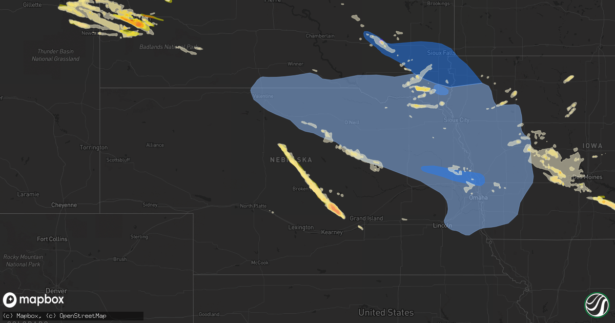
Hail Map in Nebraska on July 11, 2023
Get this storm
July 11 map
$229
one time, instant access
Download today. No call, no setup
Keep the $229
Bought the map and want the full workflow? Apply the entire $229 to a subscription within 7 days. None of it is wasted.
Every map, not just this one
This buys you this map. Subscription and you get every map we run, in the markets you choose from a few cities to whole states to nationwide. Plus real-time alerts the moment a storm fires.
Contact data
Name, contact info, occupancy, even credit band for addresses in the footprint. You go from where it hit to who to call.
Become the source they trust
Unlimited branding weather history reports on demand. You already have the documented answer ready for the property owner, and you are the one who showed up with it.
Property data and RoofTrace estimates
Pull up any address you have got, its value and the exact code rules for that jurisdiction, straight from One Click Code. Then RoofTrace estimates the squares, pitch, and roof value, priced the way you price.
Storm reports in Nebraska
Nebraska
| Date | Description |
|---|---|
| 07/11/202311:55 AM CDT | Tennis to baseball size hail reported from storm chaser... Windshield broken. |
| 07/11/20236:53 AM CDT | A local report indicates 63 MPH wind near Firth |
| 07/11/20236:41 AM CDT | Measured with two adjacent personal weather stations. |
| 07/11/20236:40 AM CDT | Personal weather station. |
| 07/11/20236:39 AM CDT | Trees down across hwy 66. |
| 07/11/20236:34 AM CDT | Tree down on house... No injuries. |
| 07/11/20236:34 AM CDT | Personal weather station. |
| 07/11/20236:33 AM CDT | Carport destroyed. |
| 07/11/20236:32 AM CDT | From a personal weather station. |
| 07/11/20236:32 AM CDT | Medium tree snapped at trunk. |
| 07/11/20236:27 AM CDT | Reported by klnk airport asos. |
| 07/11/20236:27 AM CDT | Powerlines down and sparking. |
| 07/11/20236:27 AM CDT | Personal weather station. |
| 07/11/20236:26 AM CDT | Large tree branches down. |
| 07/11/20236:23 AM CDT | A local report indicates 64 MPH wind near 2 N South Bend |
| 07/11/20236:19 AM CDT | A local report indicates 74 MPH wind near 4 N Omaha |
| 07/11/20236:16 AM CDT | Recorded at eppley airport. |
| 07/11/20236:15 AM CDT | A local report indicates 60 MPH wind near 4 NNE Bennington |
| 07/11/20236:11 AM CDT | Large tree down... Time estimated from radar. |
| 07/11/20236:10 AM CDT | Widespread tree damage reported in town. |
| 07/11/20236:09 AM CDT | Personal weather station. |
| 07/11/20236:00 AM CDT | From a personal weather station. |
| 07/11/20235:59 AM CDT | At nws omaha. |
| 07/11/20235:59 AM CDT | Measured on two adjacent personal weather stations. |
| 07/11/20235:59 AM CDT | Personal weather station. |
| 07/11/20235:59 AM CDT | Corrects previous tstm wnd gst report from 1 wnw valley. At nws omaha. |
| 07/11/20235:51 AM CDT | Lots of tree damage... Large tree snapped at trunk. |
| 07/11/20235:50 AM CDT | At fremont airport. |
| 07/11/20235:36 AM CDT | Measured by an anemometer. |
| 07/11/20235:31 AM CDT | Personal weather station. |
| 07/11/20235:29 AM CDT | As measured by a personal weather station. |
| 07/11/20235:20 AM CDT | Updates previous tstm wnd dmg report from bancroft. Widespread tree damage in and near bancroft. Power poles snapped off. Roof blown off of a machine shed. |
| 07/11/20235:20 AM CDT | Widespread tree damage in and near bancroft. |
| 07/11/20235:16 AM CDT | A local report indicates 78 MPH wind near Howells |
| 07/11/20235:14 AM CDT | Tree roughly 30 feet tall and 12 inch in diameter blocking westbound lane of hwy 20 in jackson. |
| 07/11/20235:14 AM CDT | Via personal weather station. |
| 07/11/20235:10 AM CDT | Large tree trunk snapped. |
| 07/11/20235:10 AM CDT | As recorded at a personal weather station. |
| 07/11/20235:08 AM CDT | Recorded at a personal weather station. |
| 07/11/20235:08 AM CDT | Personal weather station. |
| 07/11/20235:00 AM CDT | Corrects time to 5am estimated by radar. Tstm wnd dmg report from stanton. Tree down on house... No injuries. |
| 07/11/20234:59 AM CDT | Lots of damage to large trees throughout the city. |
| 07/11/20234:51 AM CDT | Measured at kofk asos. |
| 07/11/20234:45 AM CDT | From a personal weather station. |
| 07/11/20234:43 AM CDT | Kbrx radio station in oneill reports some tree limbs down and minor street flooding in oneill. |
| 07/11/20234:38 AM CDT | Pws via ambient weather reports. |
| 07/11/20234:15 AM CDT | Measured from personal weather station. |
| 07/11/20233:55 AM CDT | Konl awos. |
| 07/11/20233:43 AM CDT | Pws reports via ambient weather. |
| 07/11/20233:32 AM CDT | Pws reports via weather underground. |
| 07/11/20233:27 AM CDT | A local report indicates 63 MPH wind near Stuart |
| 07/11/20233:23 AM CDT | A local report indicates 62 MPH wind near 5 SW Butte |
| 07/11/20232:55 AM CDT | A local report indicates 59 MPH wind near Ainsworth AWOS |
| 07/11/20232:28 AM CDT | Asos reports another gust of 71 mph with 0.75 mmi visibility. |
| 07/11/20232:19 AM CDT | Asos reports 71 mph wind gust. |
| 07/11/20232:16 AM CDT | Asos reports 60 mph gust. |
| 07/11/202312:05 AM CDT | Mainly golf ball sized hail but a few were as big as baseballs. |
| 07/11/202312:04 AM CDT | Report from spotter network of hail to baseball size... Windshield broken. |
| 07/10/202311:55 PM CDT | Tennis to baseball size hail reported from storm chaser... Windshield broken. |
| 07/10/202311:55 PM CDT | Tennis to baseball size hail reported from storm chaser... Windshield broken. Corrected time from 1155 am to 1155 pm. |
| 07/10/202311:30 PM CDT | A local report indicates 1.50 inch wind near 2 NW Litchfield |
| 07/10/202311:28 PM CDT | Em relayed report of quarter sized hail. |
| 07/10/202311:27 PM CDT | Delayed report via nerain. Quarter sized hail lasted a few minutes. Time est from radar. |
| 07/10/202311:02 PM CDT | A local report indicates 1.50 inch wind near 4 S Weissert |
| 07/10/202310:24 PM CDT | Report relayed from emergency manager. |
All States Impacted by Hail Map on July 11, 2023
Cities Impacted by Hail Map on July 11, 2023
- Colby, KS
- Gwinn, MI
- Skandia, MI
- Lubbock, TX
- Shallowater, TX
- Wolfforth, TX
- Idalou, TX
- Slaton, TX
- Spur, TX
- Meadow, TX
- Ropesville, TX
- Tahoka, TX
- Wilson, TX
- Ransom Canyon, TX
- Lorenzo, TX
- Ralls, TX
- Clinton, OK
- Weatherford, OK
- Arapaho, OK
- Geary, OK
- Hydro, OK
- Corn, OK
- Colony, OK
- Lookeba, OK
- Hinton, OK
- Foss, OK
- Binger, OK
- Calumet, OK
- El Reno, OK
- Pocasset, OK
- Union City, OK
- Anadarko, OK
- Gracemont, OK
- Minco, OK
- Luther, OK
- Jones, OK
- Harrah, OK
- Wellston, OK
- Mcloud, OK
- Shawnee, OK
- Meeker, OK
- Earlsboro, OK
- Tecumseh, OK
- Ada, OK
- Sundance, WY
- Lead, SD
- Emory, TX
- Yantis, TX
- Sulphur Springs, TX
- Dierks, AR
- Deadwood, SD
- Point, TX
- Lone Oak, TX
- Cumby, TX
- Ferris, TX
- Nemo, SD
- Spearfish, SD
- Brashear, TX
- Iredell, TX
- Quakertown, PA
- Perkasie, PA
- Dublin, PA
- Fountainville, PA
- Doylestown, PA
- Pipersville, PA
- Ottsville, PA
- Musselshell, MT
- Ingomar, MT
- Chicago, IL
- Fort Peck, MT
- Poplar, MT
- Brockton, MT
- Culbertson, MT
- Froid, MT
- Fairview, MT
- Pontiac, MI
- Auburn Hills, MI
- Bloomfield Hills, MI
- Troy, MI
- Rochester, MI
- Utica, MI
- Macomb, MI
- New Baltimore, MI
- Washington, MI
- Ray, MI
- New Haven, MI
- Fair Haven, MI
- Casco, MI
- Circle, MT
- Tecumseh, MI
- Clinton, MI
- Manchester, MI
- Britton, MI
- Saline, MI
- Dundee, MI
- Milan, MI
- Brockway, MT
- Glendive, MT
- Terry, MT
- Fallon, MT
- Rapid City, SD
- Box Elder, SD
- Ellsworth Afb, SD
- Wibaux, MT
- Reva, SD
- Buffalo, SD
- Vassar, MI
- Saint Clair, MI
- Malta, MT
- Chelsea, MI
- Stockbridge, MI
- Gregory, MI
- Avoca, MI
- Yale, MI
- Pinckney, MI
- Columbiaville, MI
- Lapeer, MI
- Broadview, IL
- Hines, IL
- Maywood, IL
- Riverside, IL
- Jordan, MT
- Reese, MI
- Mayville, MI
- Forsyth, MT
- Silverwood, MI
- Millington, MI
- Frankenmuth, MI
- Winnett, MT
- Peerless, MT
- Capac, MI
- Summit Argo, IL
- La Grange, IL
- Bridgeview, IL
- Jonesboro, TX
- Hico, TX
- Hamilton, TX
- North Street, MI
- Jeddo, MI
- Hometown, IL
- Oak Lawn, IL
- Brookfield, IL
- Berwyn, IL
- Lyons, IL
- Burbank, IL
- Justice, IL
- Western Springs, IL
- Evergreen Park, IL
- Angie, LA
- New Underwood, SD
- Baker, MT
- Lindsay, MT
- Wyola, MT
- Decker, MT
- Sheridan, WY
- Belle Fourche, SD
- Golva, ND
- Marmarth, ND
- Rhame, ND
- Caputa, SD
- Newell, SD
- Clearmont, WY
- Ekalaka, MT
- Broadus, MT
- Biddle, MT
- Boyes, MT
- Otter, MT
- Arvada, WY
- Recluse, WY
- Gillette, WY
- Bowman, ND
- Weston, WY
- Hettinger, ND
- Mott, ND
- Ludlow, SD
- Union Center, SD
- Saint Xavier, MT
- Garryowen, MT
- Lodge Grass, MT
- Selfridge, ND
- Keldron, SD
- Lemmon, SD
- Enning, SD
- Moorcroft, WY
- Hulett, WY
- Volborg, MT
- Miles City, MT
- Ralph, SD
- Morristown, SD
- Hammond, MT
- Alzada, MT
- Devils Tower, WY
- Wasta, SD
- Prairie City, SD
- Upton, WY
- Bison, SD
- Dunning, NE
- Broken Bow, NE
- Purdum, NE
- Anselmo, NE
- Ansley, NE
- Brewster, NE
- Westerville, NE
- Johnstown, NE
- Hill City, SD
- Camp Crook, SD
- Amidon, ND
- Cohagen, MT
- Watford City, ND
- Sturgis, SD
- Smiths Creek, MI
- Meadow, SD
- Beulah, WY
- Bainville, MT
- Brusett, MT
- Osage, WY
- Newcastle, WY
- Mandaree, ND
- Faith, SD
- Aladdin, WY
- Capitol, MT
- Littlefield, TX
- Grassy Butte, ND
- Keene, ND
- Black Hawk, SD
- Sand Springs, MT
- Piedmont, SD
- Slidell, LA
- Scranton, ND
- Park City, MT
- Hermosa, SD
- Mason City, NE
- Litchfield, NE
- Hazard, NE
- Ravenna, NE
- Ismay, MT
- Mission, SD
- Valentine, NE
- Crookston, NE
- Saint Francis, SD
- Winner, SD
- Springview, NE
- Dallas, SD
- Sparks, NE
- Colome, SD
- Gregory, SD
- Burke, SD
- Wood Lake, NE
- Mills, NE
- Long Pine, NE
- Ainsworth, NE
- Mitchell, SD
- Ethan, SD
- Mount Vernon, SD
- Plankinton, SD
- Letcher, SD
- Alexandria, SD
- Parkston, SD
- Emery, SD
- Dimock, SD
- Bridgewater, SD
- Freeman, SD
- Bassett, NE
- Herrick, SD
- Stuart, NE
- Newport, NE
- Naper, NE
- Butte, NE
- Saint Charles, SD
- Bonesteel, SD
- Fairfax, SD
- Atkinson, NE
- Canistota, SD
- Marion, SD
- Melcher Dallas, IA
- Lacona, IA
- Knoxville, IA
- Milo, IA
- Chariton, IA
- Lovilia, IA
- Columbia, IA
- Albia, IA
- Amelia, NE
- Oneill, NE
- Chambers, NE
- Emmet, NE
- Wagner, SD
- Lynch, NE
- Bristow, NE
- Spencer, NE
- Inman, NE
- Dante, SD
- Niobrara, NE
- Verdigre, NE
- Springfield, SD
- Avon, SD
- Page, NE
- Lake Andes, SD
- Ewing, NE
- Orchard, NE
- Fulton, SD
- Salem, SD
- Spencer, SD
- Humboldt, SD
- Montrose, SD
- Monroe, SD
- Hartford, SD
- Sioux Falls, SD
- Renner, SD
- Parker, SD
- Brandon, SD
- Crooks, SD
- Baltic, SD
- Garretson, SD
- Chancellor, SD
- Valley Springs, SD
- Tea, SD
- Hurley, SD
- Pickstown, SD
- Geddes, SD
- Delmont, SD
- Platte, SD
- Tripp, SD
- Armour, SD
- Menno, SD
- Olivet, SD
- Tyndall, SD
- Kaylor, SD
- Scotland, SD
- Tabor, SD
- Custer, SD
- Birney, MT
- Keystone, SD
- Loup City, NE
- Bisbee, AZ
- Hereford, AZ
- West Branch, IA
- Tipton, IA
- Iowa City, IA
- Arcadia, NE
- Mud Butte, SD
- Madrid, IA
- Wanblee, SD
- Flasher, ND
- Brady, NE
- Pleasanton, NE
- Cambridge, IA
- Maxwell, IA
- Ashton, NE
- Wood River, NE
- Alda, NE
- Doniphan, NE
- Woodward, IA
- Hope, AR
- Kyle, SD
- Bouton, IA
- Slater, IA
- Sheldahl, IA
- Polk City, IA
- Granger, IA
- Merna, NE
- New Leipzig, ND
- Waco, NE
- York, NE
- Winnetoon, NE
- Creighton, NE
- Center, NE
- Royal, NE
- Billings, MT
- Harrisburg, SD
- Lennox, SD
- Luverne, MN
- Hills, MN
- Beaver Creek, MN
- Larchwood, IA
- Davis, SD
- Worthing, SD
- Viborg, SD
- Centerville, SD
- Beresford, SD
- Inwood, IA
- Canton, SD
- Steen, MN
- Fairview, SD
- Rock Valley, IA
- Hudson, SD
- Rock Rapids, IA
- Alcester, SD
- Lester, IA
- Alvord, IA
- Crofton, NE
- Clearwater, NE
- Yankton, SD
- Brunswick, NE
- Bloomfield, NE
- Meadow Grove, NE
- Osmond, NE
- Tilden, NE
- Wausa, NE
- Elgin, NE
- Pierce, NE
- Hartington, NE
- Oakdale, NE
- Plainview, NE
- Neligh, NE
- Fordyce, NE
- Doon, IA
- Hawarden, IA
- Hull, IA
- Utica, SD
- Lesterville, SD
- Randolph, NE
- Saint Helena, NE
- Vermillion, SD
- Volin, SD
- Magnet, NE
- Laurel, NE
- Battle Creek, NE
- Burbank, SD
- Elk Point, SD
- Maskell, NE
- Mission Hill, SD
- Wakonda, SD
- Belden, NE
- Gayville, SD
- Newcastle, NE
- Mclean, NE
- Wynot, NE
- Coleridge, NE
- Bartlett, NE
- Petersburg, NE
- Albion, NE
- Burwell, NE
- Newman Grove, NE
- Carroll, NE
- Winside, NE
- Dixon, NE
- Madison, NE
- Lindsay, NE
- Norfolk, NE
- Hoskins, NE
- Irene, SD
- George, IA
- Sioux Center, IA
- Orange City, IA
- Boyden, IA
- Sheldon, IA
- Maurice, IA
- Ireton, IA
- Hospers, IA
- Pender, NE
- Dodge, NE
- Emerson, NE
- Columbus, NE
- Allen, NE
- Concord, NE
- Leigh, NE
- Humphrey, NE
- Clarkson, NE
- Ponca, NE
- Wisner, NE
- Pilger, NE
- Creston, NE
- Stanton, NE
- Howells, NE
- Schuyler, NE
- Waterbury, NE
- Wayne, NE
- Wakefield, NE
- Jefferson, SD
- Scribner, NE
- Thurston, NE
- West Point, NE
- Rogers, NE
- Beemer, NE
- Jackson, NE
- Akron, IA
- Hubbard, NE
- Bancroft, NE
- Westfield, IA
- North Bend, NE
- Snyder, NE
- Dakota City, NE
- Sioux City, IA
- Winnebago, NE
- North Sioux City, SD
- South Sioux City, NE
- Homer, NE
- Rosalie, NE
- Walthill, NE
- Alton, IA
- Le Mars, IA
- Chatsworth, IA
- Brunsville, IA
- Hinton, IA
- Merrill, IA
- Salix, IA
- Craig, NE
- Lyons, NE
- Onawa, IA
- Remsen, IA
- Decatur, NE
- Sergeant Bluff, IA
- Hooper, NE
- Hornick, IA
- Moville, IA
- Bronson, IA
- Macy, NE
- Oakland, NE
- Oyens, IA
- Sloan, IA
- Whiting, IA
- Tekamah, NE
- Lawton, IA
- Kingsley, IA
- Uehling, NE
- Winslow, NE
- Ames, NE
- Fremont, NE
- Herman, NE
- Nickerson, NE
- Platte Center, NE
- Cedar Bluffs, NE
- Morse Bluff, NE
- Arlington, NE
- Colon, NE
- Prague, NE
- Malmo, NE
- Linwood, NE
- Mead, NE
- Valley, NE
- Elkhorn, NE
- Blair, NE
- Kennard, NE
- Washington, NE
- Yutan, NE
- Bennington, NE
- Granville, IA
- Climbing Hill, IA
- Washta, IA
- Pierson, IA
- Archer, IA
- Oto, IA
- Marcus, IA
- Anthon, IA
- Cleghorn, IA
- Smithland, IA
- Primghar, IA
- Correctionville, IA
- Meriden, IA
- Paullina, IA
- Cherokee, IA
- Quimby, IA
- Rodney, IA
- Castana, IA
- Missouri Valley, IA
- Little Sioux, IA
- Blencoe, IA
- Modale, IA
- Mondamin, IA
- Waterloo, NE
- Ashland, NE
- Pisgah, IA
- Fort Calhoun, NE
- Omaha, NE
- Papillion, NE
- Moorhead, IA
- Springfield, NE
- Bellevue, NE
- Boys Town, NE
- La Vista, NE
- Gretna, NE
- Crescent, IA
- Honey Creek, IA
- Carter Lake, IA
- Offutt Afb, NE
- Council Bluffs, IA
- Pacific Junction, IA
- Underwood, IA
- Silver City, IA
- Neola, IA
- Logan, IA
- McClelland, IA
- Glenwood, IA
- Woodbine, IA
- Treynor, IA
- Magnolia, IA
- Avoca, IA
- Dunlap, IA
- Oakland, IA
- Shelby, IA
- Portsmouth, IA
- Hancock, IA
- Minden, IA
- Persia, IA
- Soldier, IA
- Kimballton, IA
- Harlan, IA
- Dow City, IA
- Kirkman, IA
- Manning, IA
- Irwin, IA
- Earling, IA
- Audubon, IA
- Westphalia, IA
- Panama, IA
- Defiance, IA
- Manilla, IA
- Carroll, IA
- Aspinwall, IA
- Schleswig, IA
- Denison, IA
- Ute, IA
- Ricketts, IA
- Battle Creek, IA
- Arion, IA
- Vail, IA
- Gray, IA
- Charter Oak, IA
- Arcadia, IA
- Deloit, IA
- Mapleton, IA
- Westside, IA
- Kiron, IA
- Templeton, IA
- Halbur, IA
- Danbury, IA
- Odebolt, IA
- Holstein, IA
- Arthur, IA
- Breda, IA
- Cushing, IA
- Ida Grove, IA
- Larrabee, IA
- Wall Lake, IA
- Ithaca, NE
- Memphis, NE
- Cedar Creek, NE
- Louisville, NE
- Murdock, NE
- Greenwood, NE
- Plattsmouth, NE
- South Bend, NE
- Waverly, NE
- Wahoo, NE
- Weeping Water, NE
- Ceresco, NE
- Manley, NE
- Weston, NE
- Lincoln, NE
- Auburn, IA
- Otoe, NE
- Elmwood, NE
- Syracuse, NE
- Nehawka, NE
- Alvo, NE
- Avoca, NE
- Murray, NE
- Unadilla, NE
- Eagle, NE
- Bennet, NE
- Walton, NE
- Palmyra, NE
- Dunbar, NE
- Nebraska City, NE
- Union, NE
- Thurman, IA
- Percival, IA
- Mineola, IA
- Tabor, IA
- Malvern, IA
- Randolph, IA
- Emerson, IA
- Hastings, IA
- Imogene, IA
- Sidney, IA
- Macedonia, IA
- Henderson, IA
- Stanton, IA
- Carson, IA
- Red Oak, IA
- Essex, IA
- Farragut, IA
- Shenandoah, IA
- Elliott, IA
- Lewis, IA
- Walnut, IA
- Griswold, IA
- Villisca, IA
- Marne, IA
- Brayton, IA
- Hamlin, IA
- Elk Horn, IA
- Atlantic, IA
- Exira, IA
- Wiota, IA
- Anita, IA
- Dedham, IA
- Coon Rapids, IA
- Cumming, IA
- Norwalk, IA
- Aurelia, IA
- Storm Lake, IA
- Alta, IA
- Early, IA
- Schaller, IA
- Nemaha, IA
- Galva, IA
- Truesdale, IA
- Albert City, IA
- Lake View, IA
- Newell, IA
- Sac City, IA
- Bagley, IA
- Scranton, IA
- Bayard, IA
- Prole, IA
- Martensdale, IA
- Indianola, IA
- Eagle Grove, IA
- Thor, IA
- Goldfield, IA
- Fort Dodge, IA
- Vincent, IA
- Duncombe, IA
- Washington, IA
- Nevada, IA
- Primrose, NE
- Rippey, IA
- Jamaica, IA
- Jefferson, IA
- Grand Junction, IA
- Illinois City, IL
- Joy, IL
- New Boston, IL
- Melrose, IA
- Glidden, IA
- Prophetstown, IL
- Sheffield, IL
- Buda, IL
- Kewanee, IL
- Geneseo, IL
- Annawan, IL
- Neponset, IL
- Atkinson, IL
- Reynolds, IL
- Aledo, IL
- Perry, IA
- Dawson, IA
- Sioux Rapids, IA
- Waverly, IA
- Brighton, IA
- Toulon, IL
- Muscatine, IA
- West Liberty, IA
- Atalissa, IA
- Canova, SD
- Sanborn, IA
- Hermitage, AR
- Buckner, AR
- Lake City, IA
- Garland City, AR
- Lewisville, AR
- Stamps, AR
- Texarkana, AR
- Fouke, AR
- Wessington Springs, SD
- Alpena, SD
- Peterson, IA
- Moscow, IA
- Wilton, IA
- Plainfield, IA
- Russell, IA
- Keota, IA
- Woonsocket, SD
- Churdan, IA
- Lohrville, IA
- Yale, IA
- Guthrie Center, IA
- Rockwell City, IA
- Cambridge, IL
- Mineral, IL
- Linn Grove, IA
- Rembrandt, IA
- Denver, IA
- Tripoli, IA
- Clarksville, IA
- Saint Lawrence, SD
- Wesley, IA
- Boone, IA
- Erie, IL
- Bradford, IL
- Hillsdale, IL
- Bradley, AR
- Taylor Ridge, IL
- Panora, IA
- Redfield, IA
- Adel, IA
- Earlham, IA
- Linden, IA
- State Center, IA
- Readlyn, IA
- Clarion, IA
- Woden, IA
- Britt, IA
- Dallas Center, IA
- Minburn, IA
- Stuart, IA
- Menlo, IA
- Dexter, IA
- Algona, IA
- Burt, IA
- Dana, IA
- Shell Rock, IA
- Port Byron, IL
- Blakesburg, IA
- Dubuque, IA
- Peosta, IA
- Van Meter, IA
- Waukee, IA
- Collins, IA
- Grimes, IA
- Urbandale, IA
- Cordova, IL
- Luther, IA
- West Des Moines, IA
- Saint Charles, IA
- Des Moines, IA
- Clive, IA
- Windsor Heights, IA
- Johnston, IA
- Casey, IA
- Winterset, IA
- De Soto, IA
- Booneville, IA
- Broadwater, NE
- Bridgeport, NE
- Angora, NE
- Bayard, NE
- Minatare, NE
- Scottsbluff, NE


