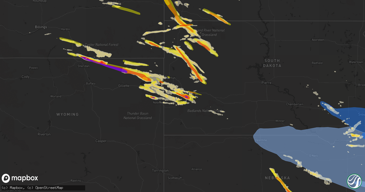
Hail Map on July 11, 2023
Get this storm
July 11 map
$229
one time, instant access
Download today. No call, no setup
Keep the $229
Bought the map and want the full workflow? Apply the entire $229 to a subscription within 7 days. None of it is wasted.
Every map, not just this one
This buys you this map. Subscription and you get every map we run, in the markets you choose from a few cities to whole states to nationwide. Plus real-time alerts the moment a storm fires.
Contact data
Name, contact info, occupancy, even credit band for addresses in the footprint. You go from where it hit to who to call.
Become the source they trust
Unlimited branding weather history reports on demand. You already have the documented answer ready for the property owner, and you are the one who showed up with it.
Property data and RoofTrace estimates
Pull up any address you have got, its value and the exact code rules for that jurisdiction, straight from One Click Code. Then RoofTrace estimates the squares, pitch, and roof value, priced the way you price.
States Impacted by Hail Map on July 11, 2023
Storm reports
Wyoming
| Date | Description |
|---|---|
| 07/11/20236:38 PM CDT | A local report indicates 2.75 inch wind near 14 NNE Sheridan |
| 07/11/202312:35 AM CDT | A local report indicates 2.50 inch wind near Osage |
| 07/11/202312:35 AM CDT | A local report indicates 1.00 inch wind near SE Osage |
| 07/10/202311:45 PM CDT | A local report indicates 60 MPH wind near 11 N Hulett |
| 07/10/202311:45 PM CDT | A local report indicates 1.00 inch wind near 11 N Hulett |
| 07/10/202310:53 PM CDT | Mostly pea... Few quarters |
| 07/10/20239:41 PM CDT | A local report indicates 1.25 inch wind near Sundance |
| 07/10/20239:27 PM CDT | A local report indicates 1.50 inch wind near 9 SSE Devils Tower |
| 07/10/20239:15 PM CDT | A local report indicates 2.00 inch wind near Devils Tower |
| 07/10/20239:15 PM CDT | A local report indicates 60 MPH wind near Devils Tower |
| 07/10/20238:59 PM CDT | A local report indicates 1.00 inch wind near 2 NW Oshoto |
| 07/10/20238:08 PM CDT | Broken windows and damaged siding. Likely more damage than that. Also estimated 50-60+ mph winds. |
| 07/10/20238:08 PM CDT | Broken windows and damaged siding. Likely more damage than that. Estimated 50-60+ mph winds with tennis ball size hail. |
| 07/10/20237:40 PM CDT | A local report indicates 1.50 inch wind near 10 NNE Wyarno |
| 07/10/20237:24 PM CDT | A local report indicates 2.75 inch wind near 9 N Leiter |
| 07/10/20237:00 PM CDT | Windows broken by hail. |
South Dakota
| Date | Description |
|---|---|
| 07/11/20236:48 PM CDT | A local report indicates 1.00 inch wind near 2 NNE Johnson Siding |
| 07/11/20235:56 PM CDT | A local report indicates 1.50 inch wind near Box Elder |
| 07/11/20233:45 PM CDT | A local report indicates 1.00 inch wind near 6 S Reva |
| 07/11/20234:39 AM CDT | Via personal weather station. |
| 07/11/20234:37 AM CDT | Several large branches snapped. Report via social media. |
| 07/11/20234:30 AM CDT | Mesonet station 16 sd rwis beresford. |
| 07/11/20234:26 AM CDT | Mesonet station bfms2 beresford 7 wsw |
| 07/11/20234:17 AM CDT | Mesonet station 197 sd rwis gayville. |
| 07/11/20234:15 AM CDT | Large branches a few trees down across the city. Winds lasted for 5 minutes. |
| 07/11/20234:14 AM CDT | Tree down. Report via social media. |
| 07/11/20234:13 AM CDT | Awos station kykn yankton municipal airport. |
| 07/11/20234:13 AM CDT | Asos station kfsd sioux falls airport. |
| 07/11/20234:12 AM CDT | Via personal weather station. |
| 07/11/20234:05 AM CDT | Via personal weather station. |
| 07/11/20234:01 AM CDT | Mesonet station 310 sd rwis parker. |
| 07/11/20233:58 AM CDT | Mesonet station 179 sd rwis tyndall. |
| 07/11/20233:55 AM CDT | Report via social media. |
| 07/11/20233:51 AM CDT | Mesonet station 163 sd rwis freeman. |
| 07/11/20233:50 AM CDT | Large tree limbs down in tyndall. Time estimated from radar. |
| 07/11/20233:50 AM CDT | Mesonet station 18 sd rwis montrose. |
| 07/11/20233:49 AM CDT | An empty cattle truck was tipped over. Time estimated from radar. |
| 07/11/20233:43 AM CDT | Pictures via social media. |
| 07/11/20233:41 AM CDT | Via personal weather station. |
| 07/11/20233:36 AM CDT | Mesonet station 26 sd rwis tripp. |
| 07/11/20233:31 AM CDT | Via multiple personal weather stations around town with peak wind gusts between 59-62 mph. |
| 07/11/20233:28 AM CDT | Mesonet station 244 sd rwis ft. Randall dam. |
| 07/11/20233:24 AM CDT | Tree snapped one foot above ground. Report via social media. |
| 07/11/20233:20 AM CDT | Mesonet station 213 sd rwis alexandria. |
| 07/11/20233:12 AM CDT | A local report indicates 68 MPH wind near Wewela |
| 07/11/20233:07 AM CDT | A local report indicates 64 MPH wind near Wewela |
| 07/11/20233:02 AM CDT | Report from mping: quarter |
| 07/11/20233:01 AM CDT | Via personal weather station. |
| 07/11/20232:57 AM CDT | A local report indicates 69 MPH wind near Wewela |
| 07/11/20232:52 AM CDT | A local report indicates 65 MPH wind near Wewela |
| 07/11/20232:48 AM CDT | Via personal weather station. |
| 07/11/20232:42 AM CDT | A local report indicates 69 MPH wind near Wewela |
| 07/11/20232:37 AM CDT | A local report indicates 60 MPH wind near Wewela |
| 07/11/20232:36 AM CDT | Mesonet station 214 sd rwis plankinton. |
| 07/11/20232:12 AM CDT | A local report indicates 64 MPH wind near 15 SSE Mission |
| 07/11/20232:07 AM CDT | A local report indicates 58 MPH wind near 15 SSE Mission |
| 07/11/202312:00 AM CDT | A local report indicates 1.00 inch wind near 5 WNW Hermosa |
| 07/10/202311:34 PM CDT | A local report indicates 1.50 inch wind near 2 WSW Rockerville |
| 07/10/202311:25 PM CDT | A local report indicates 1.50 inch wind near 4 WSW Dwtn Rapid City |
| 07/10/202311:25 PM CDT | A local report indicates 1.75 inch wind near 4 SSW Dwtn Rapid City |
| 07/10/202311:24 PM CDT | Mping report |
| 07/10/202311:23 PM CDT | A local report indicates 2.00 inch wind near 4 S Dwtn Rapid City |
| 07/10/202311:22 PM CDT | A local report indicates 1.00 inch wind near 1 S Dwtn Rapid City |
| 07/10/202311:20 PM CDT | A local report indicates 1.50 inch wind near 5 SW Dwtn Rapid City |
| 07/10/202311:20 PM CDT | Mping report |
| 07/10/202311:19 PM CDT | Mping report |
| 07/10/202311:10 PM CDT | A local report indicates 1.00 inch wind near Hisega |
| 07/10/202311:00 PM CDT | A local report indicates 1.75 inch wind near Pactola Resv |
| 07/10/202310:45 PM CDT | A local report indicates 1.75 inch wind near 4 E Ludlow |
| 07/10/202310:33 PM CDT | A local report indicates 1.75 inch wind near 1 S Ludlow |
| 07/10/202310:14 PM CDT | Mping report |
| 07/10/202310:10 PM CDT | A local report indicates 1.00 inch wind near 11 SSW Bison |
| 07/10/20239:30 PM CDT | A local report indicates 1.25 inch wind near 8 W Harding |
| 07/10/20239:30 PM CDT | A local report indicates 60 MPH wind near Reva |
| 07/10/20239:18 PM CDT | A local report indicates 1.50 inch wind near 8 SSE Ralph |
| 07/10/20239:06 PM CDT | A local report indicates 60 MPH wind near 7 NNE Ralph |
| 07/10/20238:59 PM CDT | A local report indicates 1.50 inch wind near 8 NNE Hereford |
| 07/10/20238:56 PM CDT | A local report indicates 71 MPH wind near 4 N Ludlow |
| 07/10/20238:40 PM CDT | Marbles with a few quarter hail |
| 07/10/20237:48 PM CDT | A local report indicates 1.00 inch wind near 14 ESE Castle Rock |
| 07/10/20237:21 PM CDT | A local report indicates 58 MPH wind near 7 WSW Hoover |
| 07/10/20237:19 PM CDT | A local report indicates 1.00 inch wind near 4 S Dwtn Rapid City |
| 07/10/20237:15 PM CDT | A local report indicates 1.00 inch wind near Caputa |
| 07/10/20237:14 PM CDT | A local report indicates 1.25 inch wind near 6 W Hoover |
| 07/10/20237:11 PM CDT | A local report indicates 1.25 inch wind near 4 S Dwtn Rapid City |
Michigan
| Date | Description |
|---|---|
| 07/11/20234:48 PM CDT | Large limbs down in yard near mayer and yager rds |
| 07/11/20234:30 PM CDT | Tree limbs down throughout town |
| 07/11/20234:28 PM CDT | Snapped power pole and large tree limb down on house. |
| 07/11/20234:25 PM CDT | Quarter size hail along the edge of the hail core |
| 07/11/20234:20 PM CDT | Pictures of tree uprooted... Numerous tree limbs of various sizes down |
| 07/11/20234:12 PM CDT | Social media pictures of large limbs down near m-29 and walpole. |
| 07/11/20234:05 PM CDT | Social media pictures of numerous trees down in yards... Across streets... And on power lines |
| 07/11/20234:03 PM CDT | Large tree limbs down partially blocking north ave between 26 and 27 mile rds |
| 07/11/20234:00 PM CDT | Em reports numerous trees down and damage to a barn near clinton and allen rds |
| 07/11/20233:49 PM CDT | Numerous large limbs down around 24 mile and shelby rd |
| 07/11/20233:44 PM CDT | Large limbs down causing damage to house siding near avon and dequindre |
| 07/11/20233:43 PM CDT | Large limbs down area the area of rochester rd... Hamlin rd... And avon rds |
| 07/11/20233:42 PM CDT | Social media picture of tree across road near the intersection of silverbell and gallagher rds |
| 07/11/20233:02 PM CDT | Em reports numerous trees down on houses... Numerous wires down... And a 20ft pontoon boat was flipped on halfmoon lake |
| 07/11/20233:02 PM CDT | Tree and large limbs down with small hail |
| 07/11/20232:13 PM CDT | Dispatch reports wires down across the northern portion of lapeer county with a tree down near mayville |
| 07/11/20231:52 PM CDT | Picture of quarter sized hail |
Mississippi
| Date | Description |
|---|---|
| 07/11/20233:09 PM CDT | Trees were reported down along hwy 28. |
Nebraska
| Date | Description |
|---|---|
| 07/11/202311:55 AM CDT | Tennis to baseball size hail reported from storm chaser... Windshield broken. |
| 07/11/20236:53 AM CDT | A local report indicates 63 MPH wind near Firth |
| 07/11/20236:41 AM CDT | Measured with two adjacent personal weather stations. |
| 07/11/20236:40 AM CDT | Personal weather station. |
| 07/11/20236:39 AM CDT | Trees down across hwy 66. |
| 07/11/20236:34 AM CDT | Personal weather station. |
| 07/11/20236:34 AM CDT | Tree down on house... No injuries. |
| 07/11/20236:33 AM CDT | Carport destroyed. |
| 07/11/20236:32 AM CDT | From a personal weather station. |
| 07/11/20236:32 AM CDT | Medium tree snapped at trunk. |
| 07/11/20236:27 AM CDT | Reported by klnk airport asos. |
| 07/11/20236:27 AM CDT | Powerlines down and sparking. |
| 07/11/20236:27 AM CDT | Personal weather station. |
| 07/11/20236:26 AM CDT | Large tree branches down. |
| 07/11/20236:23 AM CDT | A local report indicates 64 MPH wind near 2 N South Bend |
| 07/11/20236:19 AM CDT | A local report indicates 74 MPH wind near 4 N Omaha |
| 07/11/20236:16 AM CDT | Recorded at eppley airport. |
| 07/11/20236:15 AM CDT | A local report indicates 60 MPH wind near 4 NNE Bennington |
| 07/11/20236:11 AM CDT | Large tree down... Time estimated from radar. |
| 07/11/20236:10 AM CDT | Widespread tree damage reported in town. |
| 07/11/20236:09 AM CDT | Personal weather station. |
| 07/11/20236:00 AM CDT | From a personal weather station. |
| 07/11/20235:59 AM CDT | Personal weather station. |
| 07/11/20235:59 AM CDT | Corrects previous tstm wnd gst report from 1 wnw valley. At nws omaha. |
| 07/11/20235:59 AM CDT | At nws omaha. |
| 07/11/20235:59 AM CDT | Measured on two adjacent personal weather stations. |
| 07/11/20235:51 AM CDT | Lots of tree damage... Large tree snapped at trunk. |
| 07/11/20235:50 AM CDT | At fremont airport. |
| 07/11/20235:36 AM CDT | Measured by an anemometer. |
| 07/11/20235:31 AM CDT | Personal weather station. |
| 07/11/20235:29 AM CDT | As measured by a personal weather station. |
| 07/11/20235:20 AM CDT | Updates previous tstm wnd dmg report from bancroft. Widespread tree damage in and near bancroft. Power poles snapped off. Roof blown off of a machine shed. |
| 07/11/20235:20 AM CDT | Widespread tree damage in and near bancroft. |
| 07/11/20235:16 AM CDT | A local report indicates 78 MPH wind near Howells |
| 07/11/20235:14 AM CDT | Tree roughly 30 feet tall and 12 inch in diameter blocking westbound lane of hwy 20 in jackson. |
| 07/11/20235:14 AM CDT | Via personal weather station. |
| 07/11/20235:10 AM CDT | Large tree trunk snapped. |
| 07/11/20235:10 AM CDT | As recorded at a personal weather station. |
| 07/11/20235:08 AM CDT | Personal weather station. |
| 07/11/20235:08 AM CDT | Recorded at a personal weather station. |
| 07/11/20235:00 AM CDT | Corrects time to 5am estimated by radar. Tstm wnd dmg report from stanton. Tree down on house... No injuries. |
| 07/11/20234:59 AM CDT | Lots of damage to large trees throughout the city. |
| 07/11/20234:51 AM CDT | Measured at kofk asos. |
| 07/11/20234:45 AM CDT | From a personal weather station. |
| 07/11/20234:43 AM CDT | Kbrx radio station in oneill reports some tree limbs down and minor street flooding in oneill. |
| 07/11/20234:38 AM CDT | Pws via ambient weather reports. |
| 07/11/20234:15 AM CDT | Measured from personal weather station. |
| 07/11/20233:55 AM CDT | Konl awos. |
| 07/11/20233:43 AM CDT | Pws reports via ambient weather. |
| 07/11/20233:32 AM CDT | Pws reports via weather underground. |
| 07/11/20233:27 AM CDT | A local report indicates 63 MPH wind near Stuart |
| 07/11/20233:23 AM CDT | A local report indicates 62 MPH wind near 5 SW Butte |
| 07/11/20232:55 AM CDT | A local report indicates 59 MPH wind near Ainsworth AWOS |
| 07/11/20232:28 AM CDT | Asos reports another gust of 71 mph with 0.75 mmi visibility. |
| 07/11/20232:19 AM CDT | Asos reports 71 mph wind gust. |
| 07/11/20232:16 AM CDT | Asos reports 60 mph gust. |
| 07/11/202312:05 AM CDT | Mainly golf ball sized hail but a few were as big as baseballs. |
| 07/11/202312:04 AM CDT | Report from spotter network of hail to baseball size... Windshield broken. |
| 07/10/202311:55 PM CDT | Tennis to baseball size hail reported from storm chaser... Windshield broken. Corrected time from 1155 am to 1155 pm. |
| 07/10/202311:55 PM CDT | Tennis to baseball size hail reported from storm chaser... Windshield broken. |
| 07/10/202311:30 PM CDT | A local report indicates 1.50 inch wind near 2 NW Litchfield |
| 07/10/202311:28 PM CDT | Em relayed report of quarter sized hail. |
| 07/10/202311:27 PM CDT | Delayed report via nerain. Quarter sized hail lasted a few minutes. Time est from radar. |
| 07/10/202311:02 PM CDT | A local report indicates 1.50 inch wind near 4 S Weissert |
| 07/10/202310:24 PM CDT | Report relayed from emergency manager. |
North Dakota
| Date | Description |
|---|---|
| 07/10/20238:15 PM CDT | Hail lasted about 15 minutes 815 to 830 pm. |
| 07/10/20237:47 PM CDT | Report from social media... 6 minute duration. |
| 07/10/20237:37 PM CDT | Ongoing at time of observation. Moving north to south. |
| 07/10/20237:26 PM CDT | Ndawn mesonet site measured at 10 meters. |
Iowa
| Date | Description |
|---|---|
| 07/11/20236:58 AM CDT | A local report indicates 1.00 inch wind near 1 W Norwalk |
| 07/11/20236:38 AM CDT | Several reports of tree damage. |
| 07/11/20236:28 AM CDT | Mesonet station rsli4 storm lake. |
| 07/11/20236:26 AM CDT | Semi blown over... Part of a roof blown off a building. |
| 07/11/20236:24 AM CDT | From a personal weather station. |
| 07/11/20236:23 AM CDT | Delayed report. Large trees blown down. Roof damaged on home. |
| 07/11/20236:20 AM CDT | Siding blown off on home. |
| 07/11/20236:17 AM CDT | Pool roof blown off at titan hill intermediate school. |
| 07/11/20236:16 AM CDT | From a personal weather station. |
| 07/11/20236:15 AM CDT | Trees and large branches down in town. |
| 07/11/20236:10 AM CDT | Garage door blown in. |
| 07/11/20236:08 AM CDT | From a personal weather station. |
| 07/11/20236:03 AM CDT | Delayed report. Roof damage to a home. Windows blown out. Tree blown down. |
| 07/11/20236:03 AM CDT | Roof damaged and windows blown out on house. |
| 07/11/20236:00 AM CDT | From a personal weather station. |
| 07/11/20235:35 AM CDT | A local report indicates 60 MPH wind near Sloan |
| 07/11/20235:28 AM CDT | Via personal weather station. |
| 07/11/20235:26 AM CDT | Asos station ksux sioux gateway airport. |
| 07/11/20235:24 AM CDT | Wires down across the west side of sioux city. |
| 07/11/20234:58 AM CDT | Tree branch and powerline down over division st between 3rd and 5th st. |
| 07/11/20234:58 AM CDT | Corrects previous tstm wnd dmg report from hull. Large tree branch and powerlines down over division st between 3rd and 5th st. Damaging winds lasted for 5 minutes. |
| 07/11/20234:55 AM CDT | Tree reported down across hwy 12. |
| 07/11/20234:47 AM CDT | Power lines and large branches down. Winds lasted for 5 minutes. |
| 07/11/20234:45 AM CDT | Trees down in hawarden. Report via social media. |
Illinois
| Date | Description |
|---|---|
| 07/11/20232:33 PM CDT | A local report indicates 68 MPH wind near Midway Airport |
Texas
| Date | Description |
|---|---|
| 07/11/20235:40 AM CDT | Mesa vista awos measured 58 mph wind gust from heat burst due to nearby thunderstorm. |
| 07/11/20234:23 AM CDT | West texas mesonet 1nw of palo duro reservoir. |
Montana
| Date | Description |
|---|---|
| 07/11/20236:59 PM CDT | A local report indicates 1.50 inch wind near 20 NNE Baker |
| 07/11/20236:57 PM CDT | A local report indicates 1.00 inch wind near 7 WSW Ollie |
| 07/11/20236:31 PM CDT | Spotter reported a hail stone of 3 inches embedded within a field of 1 inch sized hail. |
| 07/11/20236:24 PM CDT | Reported at the pine hills raws site. |
| 07/11/20235:52 PM CDT | A local report indicates 1.00 inch wind near 10 NNW Marsh |
| 07/11/20235:51 PM CDT | Large cottonwood tree down |
| 07/11/20235:47 PM CDT | A local report indicates 1.00 inch wind near 10 SW Glendive |
| 07/11/20235:40 PM CDT | A local report indicates 1.00 inch wind near Circle |
| 07/11/20235:25 PM CDT | Spotter reported heavy locally heavy rainfall with 1 inch hail stones bouncing off the ground. |
| 07/11/20235:17 PM CDT | 3-4 inch tree limbs down. |
| 07/11/20235:14 PM CDT | Ping pong ball size estimated with photo. |
| 07/11/20235:07 PM CDT | Via facebook. |
| 07/11/20234:23 PM CDT | Facebook photos showed hail measuring up to ping pong ball size and accumulating on the roadways. |
| 07/11/20234:20 PM CDT | Also noted that hail was accumulating in town |
| 07/11/20234:15 PM CDT | Picture of hailstone submitted via facebook. |
| 07/11/20233:38 PM CDT | Also reported 30-40mph gusts. |
| 07/10/20239:00 PM CDT | A local report indicates 1.00 inch wind near 8 SSE Miles City |
| 07/10/20237:10 PM CDT | Picture from social media |
| 07/10/20237:05 PM CDT | Cannonball creek raws |
Cities Impacted by Hail Map on July 11, 2023
- Colby, KS
- Gwinn, MI
- Skandia, MI
- Lubbock, TX
- Shallowater, TX
- Wolfforth, TX
- Idalou, TX
- Slaton, TX
- Spur, TX
- Meadow, TX
- Ropesville, TX
- Tahoka, TX
- Wilson, TX
- Ransom Canyon, TX
- Lorenzo, TX
- Ralls, TX
- Clinton, OK
- Weatherford, OK
- Arapaho, OK
- Geary, OK
- Hydro, OK
- Corn, OK
- Colony, OK
- Lookeba, OK
- Hinton, OK
- Foss, OK
- Binger, OK
- Calumet, OK
- El Reno, OK
- Pocasset, OK
- Union City, OK
- Anadarko, OK
- Gracemont, OK
- Minco, OK
- Luther, OK
- Jones, OK
- Harrah, OK
- Wellston, OK
- Mcloud, OK
- Shawnee, OK
- Meeker, OK
- Earlsboro, OK
- Tecumseh, OK
- Ada, OK
- Sundance, WY
- Lead, SD
- Emory, TX
- Yantis, TX
- Sulphur Springs, TX
- Dierks, AR
- Deadwood, SD
- Point, TX
- Lone Oak, TX
- Cumby, TX
- Ferris, TX
- Nemo, SD
- Spearfish, SD
- Brashear, TX
- Iredell, TX
- Quakertown, PA
- Perkasie, PA
- Dublin, PA
- Fountainville, PA
- Doylestown, PA
- Pipersville, PA
- Ottsville, PA
- Musselshell, MT
- Ingomar, MT
- Chicago, IL
- Fort Peck, MT
- Poplar, MT
- Brockton, MT
- Culbertson, MT
- Froid, MT
- Fairview, MT
- Pontiac, MI
- Auburn Hills, MI
- Bloomfield Hills, MI
- Troy, MI
- Rochester, MI
- Utica, MI
- Macomb, MI
- New Baltimore, MI
- Washington, MI
- Ray, MI
- New Haven, MI
- Fair Haven, MI
- Casco, MI
- Circle, MT
- Tecumseh, MI
- Clinton, MI
- Manchester, MI
- Britton, MI
- Saline, MI
- Dundee, MI
- Milan, MI
- Brockway, MT
- Glendive, MT
- Terry, MT
- Fallon, MT
- Rapid City, SD
- Box Elder, SD
- Ellsworth Afb, SD
- Wibaux, MT
- Reva, SD
- Buffalo, SD
- Vassar, MI
- Saint Clair, MI
- Malta, MT
- Chelsea, MI
- Stockbridge, MI
- Gregory, MI
- Avoca, MI
- Yale, MI
- Pinckney, MI
- Columbiaville, MI
- Lapeer, MI
- Broadview, IL
- Hines, IL
- Maywood, IL
- Riverside, IL
- Jordan, MT
- Reese, MI
- Mayville, MI
- Forsyth, MT
- Silverwood, MI
- Millington, MI
- Frankenmuth, MI
- Winnett, MT
- Peerless, MT
- Capac, MI
- Summit Argo, IL
- La Grange, IL
- Bridgeview, IL
- Jonesboro, TX
- Hico, TX
- Hamilton, TX
- North Street, MI
- Jeddo, MI
- Hometown, IL
- Oak Lawn, IL
- Brookfield, IL
- Berwyn, IL
- Lyons, IL
- Burbank, IL
- Justice, IL
- Western Springs, IL
- Evergreen Park, IL
- Angie, LA
- New Underwood, SD
- Baker, MT
- Lindsay, MT
- Wyola, MT
- Decker, MT
- Sheridan, WY
- Belle Fourche, SD
- Golva, ND
- Marmarth, ND
- Rhame, ND
- Caputa, SD
- Newell, SD
- Clearmont, WY
- Ekalaka, MT
- Broadus, MT
- Biddle, MT
- Boyes, MT
- Otter, MT
- Arvada, WY
- Recluse, WY
- Gillette, WY
- Bowman, ND
- Weston, WY
- Hettinger, ND
- Mott, ND
- Ludlow, SD
- Union Center, SD
- Saint Xavier, MT
- Garryowen, MT
- Lodge Grass, MT
- Selfridge, ND
- Keldron, SD
- Lemmon, SD
- Enning, SD
- Moorcroft, WY
- Hulett, WY
- Volborg, MT
- Miles City, MT
- Ralph, SD
- Morristown, SD
- Hammond, MT
- Alzada, MT
- Devils Tower, WY
- Wasta, SD
- Prairie City, SD
- Upton, WY
- Bison, SD
- Dunning, NE
- Broken Bow, NE
- Purdum, NE
- Anselmo, NE
- Ansley, NE
- Brewster, NE
- Westerville, NE
- Johnstown, NE
- Hill City, SD
- Camp Crook, SD
- Amidon, ND
- Cohagen, MT
- Watford City, ND
- Sturgis, SD
- Smiths Creek, MI
- Meadow, SD
- Beulah, WY
- Bainville, MT
- Brusett, MT
- Osage, WY
- Newcastle, WY
- Mandaree, ND
- Faith, SD
- Aladdin, WY
- Capitol, MT
- Littlefield, TX
- Grassy Butte, ND
- Keene, ND
- Black Hawk, SD
- Sand Springs, MT
- Piedmont, SD
- Slidell, LA
- Scranton, ND
- Park City, MT
- Hermosa, SD
- Mason City, NE
- Litchfield, NE
- Hazard, NE
- Ravenna, NE
- Ismay, MT
- Mission, SD
- Valentine, NE
- Crookston, NE
- Saint Francis, SD
- Winner, SD
- Springview, NE
- Dallas, SD
- Sparks, NE
- Colome, SD
- Gregory, SD
- Burke, SD
- Wood Lake, NE
- Mills, NE
- Long Pine, NE
- Ainsworth, NE
- Mitchell, SD
- Ethan, SD
- Mount Vernon, SD
- Plankinton, SD
- Letcher, SD
- Alexandria, SD
- Parkston, SD
- Emery, SD
- Dimock, SD
- Bridgewater, SD
- Freeman, SD
- Bassett, NE
- Herrick, SD
- Stuart, NE
- Newport, NE
- Naper, NE
- Butte, NE
- Saint Charles, SD
- Bonesteel, SD
- Fairfax, SD
- Atkinson, NE
- Canistota, SD
- Marion, SD
- Melcher Dallas, IA
- Lacona, IA
- Knoxville, IA
- Milo, IA
- Chariton, IA
- Lovilia, IA
- Columbia, IA
- Albia, IA
- Amelia, NE
- Oneill, NE
- Chambers, NE
- Emmet, NE
- Wagner, SD
- Lynch, NE
- Bristow, NE
- Spencer, NE
- Inman, NE
- Dante, SD
- Niobrara, NE
- Verdigre, NE
- Springfield, SD
- Avon, SD
- Page, NE
- Lake Andes, SD
- Ewing, NE
- Orchard, NE
- Fulton, SD
- Salem, SD
- Spencer, SD
- Humboldt, SD
- Montrose, SD
- Monroe, SD
- Hartford, SD
- Sioux Falls, SD
- Renner, SD
- Parker, SD
- Brandon, SD
- Crooks, SD
- Baltic, SD
- Garretson, SD
- Chancellor, SD
- Valley Springs, SD
- Tea, SD
- Hurley, SD
- Pickstown, SD
- Geddes, SD
- Delmont, SD
- Platte, SD
- Tripp, SD
- Armour, SD
- Menno, SD
- Olivet, SD
- Tyndall, SD
- Kaylor, SD
- Scotland, SD
- Tabor, SD
- Custer, SD
- Birney, MT
- Keystone, SD
- Loup City, NE
- Bisbee, AZ
- Hereford, AZ
- West Branch, IA
- Tipton, IA
- Iowa City, IA
- Arcadia, NE
- Mud Butte, SD
- Madrid, IA
- Wanblee, SD
- Flasher, ND
- Brady, NE
- Pleasanton, NE
- Cambridge, IA
- Maxwell, IA
- Ashton, NE
- Wood River, NE
- Alda, NE
- Doniphan, NE
- Woodward, IA
- Hope, AR
- Kyle, SD
- Bouton, IA
- Slater, IA
- Sheldahl, IA
- Polk City, IA
- Granger, IA
- Merna, NE
- New Leipzig, ND
- Waco, NE
- York, NE
- Winnetoon, NE
- Creighton, NE
- Center, NE
- Royal, NE
- Billings, MT
- Harrisburg, SD
- Lennox, SD
- Luverne, MN
- Hills, MN
- Beaver Creek, MN
- Larchwood, IA
- Davis, SD
- Worthing, SD
- Viborg, SD
- Centerville, SD
- Beresford, SD
- Inwood, IA
- Canton, SD
- Steen, MN
- Fairview, SD
- Rock Valley, IA
- Hudson, SD
- Rock Rapids, IA
- Alcester, SD
- Lester, IA
- Alvord, IA
- Crofton, NE
- Clearwater, NE
- Yankton, SD
- Brunswick, NE
- Bloomfield, NE
- Meadow Grove, NE
- Osmond, NE
- Tilden, NE
- Wausa, NE
- Elgin, NE
- Pierce, NE
- Hartington, NE
- Oakdale, NE
- Plainview, NE
- Neligh, NE
- Fordyce, NE
- Doon, IA
- Hawarden, IA
- Hull, IA
- Utica, SD
- Lesterville, SD
- Randolph, NE
- Saint Helena, NE
- Vermillion, SD
- Volin, SD
- Magnet, NE
- Laurel, NE
- Battle Creek, NE
- Burbank, SD
- Elk Point, SD
- Maskell, NE
- Mission Hill, SD
- Wakonda, SD
- Belden, NE
- Gayville, SD
- Newcastle, NE
- Mclean, NE
- Wynot, NE
- Coleridge, NE
- Bartlett, NE
- Petersburg, NE
- Albion, NE
- Burwell, NE
- Newman Grove, NE
- Carroll, NE
- Winside, NE
- Dixon, NE
- Madison, NE
- Lindsay, NE
- Norfolk, NE
- Hoskins, NE
- Irene, SD
- George, IA
- Sioux Center, IA
- Orange City, IA
- Boyden, IA
- Sheldon, IA
- Maurice, IA
- Ireton, IA
- Hospers, IA
- Pender, NE
- Dodge, NE
- Emerson, NE
- Columbus, NE
- Allen, NE
- Concord, NE
- Leigh, NE
- Humphrey, NE
- Clarkson, NE
- Ponca, NE
- Wisner, NE
- Pilger, NE
- Creston, NE
- Stanton, NE
- Howells, NE
- Schuyler, NE
- Waterbury, NE
- Wayne, NE
- Wakefield, NE
- Jefferson, SD
- Scribner, NE
- Thurston, NE
- West Point, NE
- Rogers, NE
- Beemer, NE
- Jackson, NE
- Akron, IA
- Hubbard, NE
- Bancroft, NE
- Westfield, IA
- North Bend, NE
- Snyder, NE
- Dakota City, NE
- Sioux City, IA
- Winnebago, NE
- North Sioux City, SD
- South Sioux City, NE
- Homer, NE
- Rosalie, NE
- Walthill, NE
- Alton, IA
- Le Mars, IA
- Chatsworth, IA
- Brunsville, IA
- Hinton, IA
- Merrill, IA
- Salix, IA
- Craig, NE
- Lyons, NE
- Onawa, IA
- Remsen, IA
- Decatur, NE
- Sergeant Bluff, IA
- Hooper, NE
- Hornick, IA
- Moville, IA
- Bronson, IA
- Macy, NE
- Oakland, NE
- Oyens, IA
- Sloan, IA
- Whiting, IA
- Tekamah, NE
- Lawton, IA
- Kingsley, IA
- Uehling, NE
- Winslow, NE
- Ames, NE
- Fremont, NE
- Herman, NE
- Nickerson, NE
- Platte Center, NE
- Cedar Bluffs, NE
- Morse Bluff, NE
- Arlington, NE
- Colon, NE
- Prague, NE
- Malmo, NE
- Linwood, NE
- Mead, NE
- Valley, NE
- Elkhorn, NE
- Blair, NE
- Kennard, NE
- Washington, NE
- Yutan, NE
- Bennington, NE
- Granville, IA
- Climbing Hill, IA
- Washta, IA
- Pierson, IA
- Archer, IA
- Oto, IA
- Marcus, IA
- Anthon, IA
- Cleghorn, IA
- Smithland, IA
- Primghar, IA
- Correctionville, IA
- Meriden, IA
- Paullina, IA
- Cherokee, IA
- Quimby, IA
- Rodney, IA
- Castana, IA
- Missouri Valley, IA
- Little Sioux, IA
- Blencoe, IA
- Modale, IA
- Mondamin, IA
- Waterloo, NE
- Ashland, NE
- Pisgah, IA
- Fort Calhoun, NE
- Omaha, NE
- Papillion, NE
- Moorhead, IA
- Springfield, NE
- Bellevue, NE
- Boys Town, NE
- La Vista, NE
- Gretna, NE
- Crescent, IA
- Honey Creek, IA
- Carter Lake, IA
- Offutt Afb, NE
- Council Bluffs, IA
- Pacific Junction, IA
- Underwood, IA
- Silver City, IA
- Neola, IA
- Logan, IA
- McClelland, IA
- Glenwood, IA
- Woodbine, IA
- Treynor, IA
- Magnolia, IA
- Avoca, IA
- Dunlap, IA
- Oakland, IA
- Shelby, IA
- Portsmouth, IA
- Hancock, IA
- Minden, IA
- Persia, IA
- Soldier, IA
- Kimballton, IA
- Harlan, IA
- Dow City, IA
- Kirkman, IA
- Manning, IA
- Irwin, IA
- Earling, IA
- Audubon, IA
- Westphalia, IA
- Panama, IA
- Defiance, IA
- Manilla, IA
- Carroll, IA
- Aspinwall, IA
- Schleswig, IA
- Denison, IA
- Ute, IA
- Ricketts, IA
- Battle Creek, IA
- Arion, IA
- Vail, IA
- Gray, IA
- Charter Oak, IA
- Arcadia, IA
- Deloit, IA
- Mapleton, IA
- Westside, IA
- Kiron, IA
- Templeton, IA
- Halbur, IA
- Danbury, IA
- Odebolt, IA
- Holstein, IA
- Arthur, IA
- Breda, IA
- Cushing, IA
- Ida Grove, IA
- Larrabee, IA
- Wall Lake, IA
- Ithaca, NE
- Memphis, NE
- Cedar Creek, NE
- Louisville, NE
- Murdock, NE
- Greenwood, NE
- Plattsmouth, NE
- South Bend, NE
- Waverly, NE
- Wahoo, NE
- Weeping Water, NE
- Ceresco, NE
- Manley, NE
- Weston, NE
- Lincoln, NE
- Auburn, IA
- Otoe, NE
- Elmwood, NE
- Syracuse, NE
- Nehawka, NE
- Alvo, NE
- Avoca, NE
- Murray, NE
- Unadilla, NE
- Eagle, NE
- Bennet, NE
- Walton, NE
- Palmyra, NE
- Dunbar, NE
- Nebraska City, NE
- Union, NE
- Thurman, IA
- Percival, IA
- Mineola, IA
- Tabor, IA
- Malvern, IA
- Randolph, IA
- Emerson, IA
- Hastings, IA
- Imogene, IA
- Sidney, IA
- Macedonia, IA
- Henderson, IA
- Stanton, IA
- Carson, IA
- Red Oak, IA
- Essex, IA
- Farragut, IA
- Shenandoah, IA
- Elliott, IA
- Lewis, IA
- Walnut, IA
- Griswold, IA
- Villisca, IA
- Marne, IA
- Brayton, IA
- Hamlin, IA
- Elk Horn, IA
- Atlantic, IA
- Exira, IA
- Wiota, IA
- Anita, IA
- Dedham, IA
- Coon Rapids, IA
- Cumming, IA
- Norwalk, IA
- Aurelia, IA
- Storm Lake, IA
- Alta, IA
- Early, IA
- Schaller, IA
- Nemaha, IA
- Galva, IA
- Truesdale, IA
- Albert City, IA
- Lake View, IA
- Newell, IA
- Sac City, IA
- Bagley, IA
- Scranton, IA
- Bayard, IA
- Prole, IA
- Martensdale, IA
- Indianola, IA
- Eagle Grove, IA
- Thor, IA
- Goldfield, IA
- Fort Dodge, IA
- Vincent, IA
- Duncombe, IA
- Washington, IA
- Nevada, IA
- Primrose, NE
- Rippey, IA
- Jamaica, IA
- Jefferson, IA
- Grand Junction, IA
- Illinois City, IL
- Joy, IL
- New Boston, IL
- Melrose, IA
- Glidden, IA
- Prophetstown, IL
- Sheffield, IL
- Buda, IL
- Kewanee, IL
- Geneseo, IL
- Annawan, IL
- Neponset, IL
- Atkinson, IL
- Reynolds, IL
- Aledo, IL
- Perry, IA
- Dawson, IA
- Sioux Rapids, IA
- Waverly, IA
- Brighton, IA
- Toulon, IL
- Muscatine, IA
- West Liberty, IA
- Atalissa, IA
- Canova, SD
- Sanborn, IA
- Hermitage, AR
- Buckner, AR
- Lake City, IA
- Garland City, AR
- Lewisville, AR
- Stamps, AR
- Texarkana, AR
- Fouke, AR
- Wessington Springs, SD
- Alpena, SD
- Peterson, IA
- Moscow, IA
- Wilton, IA
- Plainfield, IA
- Russell, IA
- Keota, IA
- Woonsocket, SD
- Churdan, IA
- Lohrville, IA
- Yale, IA
- Guthrie Center, IA
- Rockwell City, IA
- Cambridge, IL
- Mineral, IL
- Linn Grove, IA
- Rembrandt, IA
- Denver, IA
- Tripoli, IA
- Clarksville, IA
- Saint Lawrence, SD
- Wesley, IA
- Boone, IA
- Erie, IL
- Bradford, IL
- Hillsdale, IL
- Bradley, AR
- Taylor Ridge, IL
- Panora, IA
- Redfield, IA
- Adel, IA
- Earlham, IA
- Linden, IA
- State Center, IA
- Readlyn, IA
- Clarion, IA
- Woden, IA
- Britt, IA
- Dallas Center, IA
- Minburn, IA
- Stuart, IA
- Menlo, IA
- Dexter, IA
- Algona, IA
- Burt, IA
- Dana, IA
- Shell Rock, IA
- Port Byron, IL
- Blakesburg, IA
- Dubuque, IA
- Peosta, IA
- Van Meter, IA
- Waukee, IA
- Collins, IA
- Grimes, IA
- Urbandale, IA
- Cordova, IL
- Luther, IA
- West Des Moines, IA
- Saint Charles, IA
- Des Moines, IA
- Clive, IA
- Windsor Heights, IA
- Johnston, IA
- Casey, IA
- Winterset, IA
- De Soto, IA
- Booneville, IA
- Broadwater, NE
- Bridgeport, NE
- Angora, NE
- Bayard, NE
- Minatare, NE
- Scottsbluff, NE