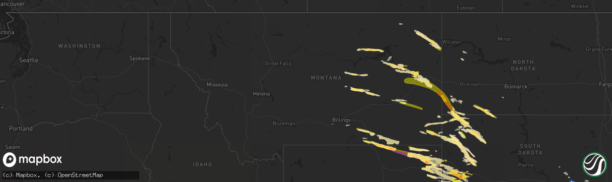
Hail Map in Montana on July 11, 2023
The weather event in Montana on July 11, 2023 includes Hail and Wind maps. 16 states and 841 cities were impacted and suffered possible damage. The total estimated number of properties impacted is 3,488.
Want more than just the map?
Turn this storm into a full workflow.
- Owner + property data so you know who to knock
- OnDemand branded weather history reports to win the "did we even have hail?" argument
- RoofTrace estimate so reps stop guessing numbers at the door
Bought this map? Upgrade within 7 days and we'll credit the $230. (10-15 min setup call)
Hail
Wind
3,488
Estimated number of impacted properties by a 1.00" hail or larger767
Estimated number of impacted properties by a 1.75" hail or larger7
Estimated number of impacted properties by a 2.50" hail or largerStorm reports in Montana
Montana
| Date | Description |
|---|---|
| 07/11/20236:59 PM CDT | A local report indicates 1.50 inch wind near 20 NNE Baker |
| 07/11/20236:57 PM CDT | A local report indicates 1.00 inch wind near 7 WSW Ollie |
| 07/11/20236:31 PM CDT | Spotter reported a hail stone of 3 inches embedded within a field of 1 inch sized hail. |
| 07/11/20236:24 PM CDT | Reported at the pine hills raws site. |
| 07/11/20235:52 PM CDT | A local report indicates 1.00 inch wind near 10 NNW Marsh |
| 07/11/20235:51 PM CDT | Large cottonwood tree down |
| 07/11/20235:47 PM CDT | A local report indicates 1.00 inch wind near 10 SW Glendive |
| 07/11/20235:40 PM CDT | A local report indicates 1.00 inch wind near Circle |
| 07/11/20235:25 PM CDT | Spotter reported heavy locally heavy rainfall with 1 inch hail stones bouncing off the ground. |
| 07/11/20235:17 PM CDT | 3-4 inch tree limbs down. |
| 07/11/20235:14 PM CDT | Ping pong ball size estimated with photo. |
| 07/11/20235:07 PM CDT | Via facebook. |
| 07/11/20234:23 PM CDT | Facebook photos showed hail measuring up to ping pong ball size and accumulating on the roadways. |
| 07/11/20234:20 PM CDT | Also noted that hail was accumulating in town |
| 07/11/20234:15 PM CDT | Picture of hailstone submitted via facebook. |
| 07/11/20233:38 PM CDT | Also reported 30-40mph gusts. |
| 07/10/20239:00 PM CDT | A local report indicates 1.00 inch wind near 8 SSE Miles City |
| 07/10/20237:10 PM CDT | Picture from social media |
| 07/10/20237:05 PM CDT | Cannonball creek raws |
All States Impacted by Hail Map on July 11, 2023
Cities Impacted by Hail Map on July 11, 2023
- Colby, KS
- Gwinn, MI
- Skandia, MI
- Lubbock, TX
- Shallowater, TX
- Wolfforth, TX
- Idalou, TX
- Slaton, TX
- Spur, TX
- Meadow, TX
- Ropesville, TX
- Tahoka, TX
- Wilson, TX
- Ransom Canyon, TX
- Lorenzo, TX
- Ralls, TX
- Clinton, OK
- Weatherford, OK
- Arapaho, OK
- Geary, OK
- Hydro, OK
- Corn, OK
- Colony, OK
- Lookeba, OK
- Hinton, OK
- Foss, OK
- Binger, OK
- Calumet, OK
- El Reno, OK
- Pocasset, OK
- Union City, OK
- Anadarko, OK
- Gracemont, OK
- Minco, OK
- Luther, OK
- Jones, OK
- Harrah, OK
- Wellston, OK
- Mcloud, OK
- Shawnee, OK
- Meeker, OK
- Earlsboro, OK
- Tecumseh, OK
- Ada, OK
- Sundance, WY
- Lead, SD
- Emory, TX
- Yantis, TX
- Sulphur Springs, TX
- Dierks, AR
- Deadwood, SD
- Point, TX
- Lone Oak, TX
- Cumby, TX
- Ferris, TX
- Nemo, SD
- Spearfish, SD
- Brashear, TX
- Iredell, TX
- Quakertown, PA
- Perkasie, PA
- Dublin, PA
- Fountainville, PA
- Doylestown, PA
- Pipersville, PA
- Ottsville, PA
- Musselshell, MT
- Ingomar, MT
- Chicago, IL
- Fort Peck, MT
- Poplar, MT
- Brockton, MT
- Culbertson, MT
- Froid, MT
- Fairview, MT
- Pontiac, MI
- Auburn Hills, MI
- Bloomfield Hills, MI
- Troy, MI
- Rochester, MI
- Utica, MI
- Macomb, MI
- New Baltimore, MI
- Washington, MI
- Ray, MI
- New Haven, MI
- Fair Haven, MI
- Casco, MI
- Circle, MT
- Tecumseh, MI
- Clinton, MI
- Manchester, MI
- Britton, MI
- Saline, MI
- Dundee, MI
- Milan, MI
- Brockway, MT
- Glendive, MT
- Terry, MT
- Fallon, MT
- Rapid City, SD
- Box Elder, SD
- Ellsworth Afb, SD
- Wibaux, MT
- Reva, SD
- Buffalo, SD
- Vassar, MI
- Saint Clair, MI
- Malta, MT
- Chelsea, MI
- Stockbridge, MI
- Gregory, MI
- Avoca, MI
- Yale, MI
- Pinckney, MI
- Columbiaville, MI
- Lapeer, MI
- Broadview, IL
- Hines, IL
- Maywood, IL
- Riverside, IL
- Jordan, MT
- Reese, MI
- Mayville, MI
- Forsyth, MT
- Silverwood, MI
- Millington, MI
- Frankenmuth, MI
- Winnett, MT
- Peerless, MT
- Capac, MI
- Summit Argo, IL
- La Grange, IL
- Bridgeview, IL
- Jonesboro, TX
- Hico, TX
- Hamilton, TX
- North Street, MI
- Jeddo, MI
- Hometown, IL
- Oak Lawn, IL
- Brookfield, IL
- Berwyn, IL
- Lyons, IL
- Burbank, IL
- Justice, IL
- Western Springs, IL
- Evergreen Park, IL
- Angie, LA
- New Underwood, SD
- Baker, MT
- Lindsay, MT
- Wyola, MT
- Decker, MT
- Sheridan, WY
- Belle Fourche, SD
- Golva, ND
- Marmarth, ND
- Rhame, ND
- Caputa, SD
- Newell, SD
- Clearmont, WY
- Ekalaka, MT
- Broadus, MT
- Biddle, MT
- Boyes, MT
- Otter, MT
- Arvada, WY
- Recluse, WY
- Gillette, WY
- Bowman, ND
- Weston, WY
- Hettinger, ND
- Mott, ND
- Ludlow, SD
- Union Center, SD
- Saint Xavier, MT
- Garryowen, MT
- Lodge Grass, MT
- Selfridge, ND
- Keldron, SD
- Lemmon, SD
- Enning, SD
- Moorcroft, WY
- Hulett, WY
- Volborg, MT
- Miles City, MT
- Ralph, SD
- Morristown, SD
- Hammond, MT
- Alzada, MT
- Devils Tower, WY
- Wasta, SD
- Prairie City, SD
- Upton, WY
- Bison, SD
- Dunning, NE
- Broken Bow, NE
- Purdum, NE
- Anselmo, NE
- Ansley, NE
- Brewster, NE
- Westerville, NE
- Johnstown, NE
- Hill City, SD
- Camp Crook, SD
- Amidon, ND
- Cohagen, MT
- Watford City, ND
- Sturgis, SD
- Smiths Creek, MI
- Meadow, SD
- Beulah, WY
- Bainville, MT
- Brusett, MT
- Osage, WY
- Newcastle, WY
- Mandaree, ND
- Faith, SD
- Aladdin, WY
- Capitol, MT
- Littlefield, TX
- Grassy Butte, ND
- Keene, ND
- Black Hawk, SD
- Sand Springs, MT
- Piedmont, SD
- Slidell, LA
- Scranton, ND
- Park City, MT
- Hermosa, SD
- Mason City, NE
- Litchfield, NE
- Hazard, NE
- Ravenna, NE
- Ismay, MT
- Mission, SD
- Valentine, NE
- Crookston, NE
- Saint Francis, SD
- Winner, SD
- Springview, NE
- Dallas, SD
- Sparks, NE
- Colome, SD
- Gregory, SD
- Burke, SD
- Wood Lake, NE
- Mills, NE
- Long Pine, NE
- Ainsworth, NE
- Mitchell, SD
- Ethan, SD
- Mount Vernon, SD
- Plankinton, SD
- Letcher, SD
- Alexandria, SD
- Parkston, SD
- Emery, SD
- Dimock, SD
- Bridgewater, SD
- Freeman, SD
- Bassett, NE
- Herrick, SD
- Stuart, NE
- Newport, NE
- Naper, NE
- Butte, NE
- Saint Charles, SD
- Bonesteel, SD
- Fairfax, SD
- Atkinson, NE
- Canistota, SD
- Marion, SD
- Melcher Dallas, IA
- Lacona, IA
- Knoxville, IA
- Milo, IA
- Chariton, IA
- Lovilia, IA
- Columbia, IA
- Albia, IA
- Amelia, NE
- Oneill, NE
- Chambers, NE
- Emmet, NE
- Wagner, SD
- Lynch, NE
- Bristow, NE
- Spencer, NE
- Inman, NE
- Dante, SD
- Niobrara, NE
- Verdigre, NE
- Springfield, SD
- Avon, SD
- Page, NE
- Lake Andes, SD
- Ewing, NE
- Orchard, NE
- Fulton, SD
- Salem, SD
- Spencer, SD
- Humboldt, SD
- Montrose, SD
- Monroe, SD
- Hartford, SD
- Sioux Falls, SD
- Renner, SD
- Parker, SD
- Brandon, SD
- Crooks, SD
- Baltic, SD
- Garretson, SD
- Chancellor, SD
- Valley Springs, SD
- Tea, SD
- Hurley, SD
- Pickstown, SD
- Geddes, SD
- Delmont, SD
- Platte, SD
- Tripp, SD
- Armour, SD
- Menno, SD
- Olivet, SD
- Tyndall, SD
- Kaylor, SD
- Scotland, SD
- Tabor, SD
- Custer, SD
- Birney, MT
- Keystone, SD
- Loup City, NE
- Bisbee, AZ
- Hereford, AZ
- West Branch, IA
- Tipton, IA
- Iowa City, IA
- Arcadia, NE
- Mud Butte, SD
- Madrid, IA
- Wanblee, SD
- Flasher, ND
- Brady, NE
- Pleasanton, NE
- Cambridge, IA
- Maxwell, IA
- Ashton, NE
- Wood River, NE
- Alda, NE
- Doniphan, NE
- Woodward, IA
- Hope, AR
- Kyle, SD
- Bouton, IA
- Slater, IA
- Sheldahl, IA
- Polk City, IA
- Granger, IA
- Merna, NE
- New Leipzig, ND
- Waco, NE
- York, NE
- Winnetoon, NE
- Creighton, NE
- Center, NE
- Royal, NE
- Billings, MT
- Harrisburg, SD
- Lennox, SD
- Luverne, MN
- Hills, MN
- Beaver Creek, MN
- Larchwood, IA
- Davis, SD
- Worthing, SD
- Viborg, SD
- Centerville, SD
- Beresford, SD
- Inwood, IA
- Canton, SD
- Steen, MN
- Fairview, SD
- Rock Valley, IA
- Hudson, SD
- Rock Rapids, IA
- Alcester, SD
- Lester, IA
- Alvord, IA
- Crofton, NE
- Clearwater, NE
- Yankton, SD
- Brunswick, NE
- Bloomfield, NE
- Meadow Grove, NE
- Osmond, NE
- Tilden, NE
- Wausa, NE
- Elgin, NE
- Pierce, NE
- Hartington, NE
- Oakdale, NE
- Plainview, NE
- Neligh, NE
- Fordyce, NE
- Doon, IA
- Hawarden, IA
- Hull, IA
- Utica, SD
- Lesterville, SD
- Randolph, NE
- Saint Helena, NE
- Vermillion, SD
- Volin, SD
- Magnet, NE
- Laurel, NE
- Battle Creek, NE
- Burbank, SD
- Elk Point, SD
- Maskell, NE
- Mission Hill, SD
- Wakonda, SD
- Belden, NE
- Gayville, SD
- Newcastle, NE
- Mclean, NE
- Wynot, NE
- Coleridge, NE
- Bartlett, NE
- Petersburg, NE
- Albion, NE
- Burwell, NE
- Newman Grove, NE
- Carroll, NE
- Winside, NE
- Dixon, NE
- Madison, NE
- Lindsay, NE
- Norfolk, NE
- Hoskins, NE
- Irene, SD
- George, IA
- Sioux Center, IA
- Orange City, IA
- Boyden, IA
- Sheldon, IA
- Maurice, IA
- Ireton, IA
- Hospers, IA
- Pender, NE
- Dodge, NE
- Emerson, NE
- Columbus, NE
- Allen, NE
- Concord, NE
- Leigh, NE
- Humphrey, NE
- Clarkson, NE
- Ponca, NE
- Wisner, NE
- Pilger, NE
- Creston, NE
- Stanton, NE
- Howells, NE
- Schuyler, NE
- Waterbury, NE
- Wayne, NE
- Wakefield, NE
- Jefferson, SD
- Scribner, NE
- Thurston, NE
- West Point, NE
- Rogers, NE
- Beemer, NE
- Jackson, NE
- Akron, IA
- Hubbard, NE
- Bancroft, NE
- Westfield, IA
- North Bend, NE
- Snyder, NE
- Dakota City, NE
- Sioux City, IA
- Winnebago, NE
- North Sioux City, SD
- South Sioux City, NE
- Homer, NE
- Rosalie, NE
- Walthill, NE
- Alton, IA
- Le Mars, IA
- Chatsworth, IA
- Brunsville, IA
- Hinton, IA
- Merrill, IA
- Salix, IA
- Craig, NE
- Lyons, NE
- Onawa, IA
- Remsen, IA
- Decatur, NE
- Sergeant Bluff, IA
- Hooper, NE
- Hornick, IA
- Moville, IA
- Bronson, IA
- Macy, NE
- Oakland, NE
- Oyens, IA
- Sloan, IA
- Whiting, IA
- Tekamah, NE
- Lawton, IA
- Kingsley, IA
- Uehling, NE
- Winslow, NE
- Ames, NE
- Fremont, NE
- Herman, NE
- Nickerson, NE
- Platte Center, NE
- Cedar Bluffs, NE
- Morse Bluff, NE
- Arlington, NE
- Colon, NE
- Prague, NE
- Malmo, NE
- Linwood, NE
- Mead, NE
- Valley, NE
- Elkhorn, NE
- Blair, NE
- Kennard, NE
- Washington, NE
- Yutan, NE
- Bennington, NE
- Granville, IA
- Climbing Hill, IA
- Washta, IA
- Pierson, IA
- Archer, IA
- Oto, IA
- Marcus, IA
- Anthon, IA
- Cleghorn, IA
- Smithland, IA
- Primghar, IA
- Correctionville, IA
- Meriden, IA
- Paullina, IA
- Cherokee, IA
- Quimby, IA
- Rodney, IA
- Castana, IA
- Missouri Valley, IA
- Little Sioux, IA
- Blencoe, IA
- Modale, IA
- Mondamin, IA
- Waterloo, NE
- Ashland, NE
- Pisgah, IA
- Fort Calhoun, NE
- Omaha, NE
- Papillion, NE
- Moorhead, IA
- Springfield, NE
- Bellevue, NE
- Boys Town, NE
- La Vista, NE
- Gretna, NE
- Crescent, IA
- Honey Creek, IA
- Carter Lake, IA
- Offutt Afb, NE
- Council Bluffs, IA
- Pacific Junction, IA
- Underwood, IA
- Silver City, IA
- Neola, IA
- Logan, IA
- McClelland, IA
- Glenwood, IA
- Woodbine, IA
- Treynor, IA
- Magnolia, IA
- Avoca, IA
- Dunlap, IA
- Oakland, IA
- Shelby, IA
- Portsmouth, IA
- Hancock, IA
- Minden, IA
- Persia, IA
- Soldier, IA
- Kimballton, IA
- Harlan, IA
- Dow City, IA
- Kirkman, IA
- Manning, IA
- Irwin, IA
- Earling, IA
- Audubon, IA
- Westphalia, IA
- Panama, IA
- Defiance, IA
- Manilla, IA
- Carroll, IA
- Aspinwall, IA
- Schleswig, IA
- Denison, IA
- Ute, IA
- Ricketts, IA
- Battle Creek, IA
- Arion, IA
- Vail, IA
- Gray, IA
- Charter Oak, IA
- Arcadia, IA
- Deloit, IA
- Mapleton, IA
- Westside, IA
- Kiron, IA
- Templeton, IA
- Halbur, IA
- Danbury, IA
- Odebolt, IA
- Holstein, IA
- Arthur, IA
- Breda, IA
- Cushing, IA
- Ida Grove, IA
- Larrabee, IA
- Wall Lake, IA
- Ithaca, NE
- Memphis, NE
- Cedar Creek, NE
- Louisville, NE
- Murdock, NE
- Greenwood, NE
- Plattsmouth, NE
- South Bend, NE
- Waverly, NE
- Wahoo, NE
- Weeping Water, NE
- Ceresco, NE
- Manley, NE
- Weston, NE
- Lincoln, NE
- Auburn, IA
- Otoe, NE
- Elmwood, NE
- Syracuse, NE
- Nehawka, NE
- Alvo, NE
- Avoca, NE
- Murray, NE
- Unadilla, NE
- Eagle, NE
- Bennet, NE
- Walton, NE
- Palmyra, NE
- Dunbar, NE
- Nebraska City, NE
- Union, NE
- Thurman, IA
- Percival, IA
- Mineola, IA
- Tabor, IA
- Malvern, IA
- Randolph, IA
- Emerson, IA
- Hastings, IA
- Imogene, IA
- Sidney, IA
- Macedonia, IA
- Henderson, IA
- Stanton, IA
- Carson, IA
- Red Oak, IA
- Essex, IA
- Farragut, IA
- Shenandoah, IA
- Elliott, IA
- Lewis, IA
- Walnut, IA
- Griswold, IA
- Villisca, IA
- Marne, IA
- Brayton, IA
- Hamlin, IA
- Elk Horn, IA
- Atlantic, IA
- Exira, IA
- Wiota, IA
- Anita, IA
- Dedham, IA
- Coon Rapids, IA
- Cumming, IA
- Norwalk, IA
- Aurelia, IA
- Storm Lake, IA
- Alta, IA
- Early, IA
- Schaller, IA
- Nemaha, IA
- Galva, IA
- Truesdale, IA
- Albert City, IA
- Lake View, IA
- Newell, IA
- Sac City, IA
- Bagley, IA
- Scranton, IA
- Bayard, IA
- Prole, IA
- Martensdale, IA
- Indianola, IA
- Eagle Grove, IA
- Thor, IA
- Goldfield, IA
- Fort Dodge, IA
- Vincent, IA
- Duncombe, IA
- Washington, IA
- Nevada, IA
- Primrose, NE
- Rippey, IA
- Jamaica, IA
- Jefferson, IA
- Grand Junction, IA
- Illinois City, IL
- Joy, IL
- New Boston, IL
- Melrose, IA
- Glidden, IA
- Prophetstown, IL
- Sheffield, IL
- Buda, IL
- Kewanee, IL
- Geneseo, IL
- Annawan, IL
- Neponset, IL
- Atkinson, IL
- Reynolds, IL
- Aledo, IL
- Perry, IA
- Dawson, IA
- Sioux Rapids, IA
- Waverly, IA
- Brighton, IA
- Toulon, IL
- Muscatine, IA
- West Liberty, IA
- Atalissa, IA
- Canova, SD
- Sanborn, IA
- Hermitage, AR
- Buckner, AR
- Lake City, IA
- Garland City, AR
- Lewisville, AR
- Stamps, AR
- Texarkana, AR
- Fouke, AR
- Wessington Springs, SD
- Alpena, SD
- Peterson, IA
- Moscow, IA
- Wilton, IA
- Plainfield, IA
- Russell, IA
- Keota, IA
- Woonsocket, SD
- Churdan, IA
- Lohrville, IA
- Yale, IA
- Guthrie Center, IA
- Rockwell City, IA
- Cambridge, IL
- Mineral, IL
- Linn Grove, IA
- Rembrandt, IA
- Denver, IA
- Tripoli, IA
- Clarksville, IA
- Saint Lawrence, SD
- Wesley, IA
- Boone, IA
- Erie, IL
- Bradford, IL
- Hillsdale, IL
- Bradley, AR
- Taylor Ridge, IL
- Panora, IA
- Redfield, IA
- Adel, IA
- Earlham, IA
- Linden, IA
- State Center, IA
- Readlyn, IA
- Clarion, IA
- Woden, IA
- Britt, IA
- Dallas Center, IA
- Minburn, IA
- Stuart, IA
- Menlo, IA
- Dexter, IA
- Algona, IA
- Burt, IA
- Dana, IA
- Shell Rock, IA
- Port Byron, IL
- Blakesburg, IA
- Dubuque, IA
- Peosta, IA
- Van Meter, IA
- Waukee, IA
- Collins, IA
- Grimes, IA
- Urbandale, IA
- Cordova, IL
- Luther, IA
- West Des Moines, IA
- Saint Charles, IA
- Des Moines, IA
- Clive, IA
- Windsor Heights, IA
- Johnston, IA
- Casey, IA
- Winterset, IA
- De Soto, IA
- Booneville, IA
- Broadwater, NE
- Bridgeport, NE
- Angora, NE
- Bayard, NE
- Minatare, NE
- Scottsbluff, NE


