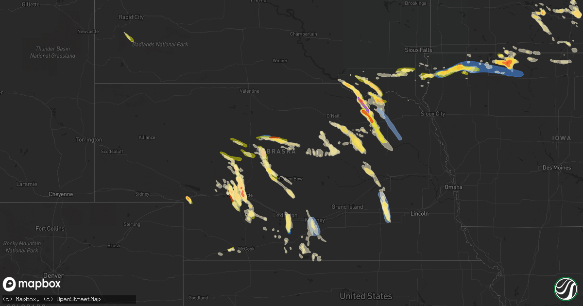
Hail Map in Nebraska on July 10, 2023
Get this storm
July 10 map
$229
one time, instant access
Download today. No call, no setup
Keep the $229
Bought the map and want the full workflow? Apply the entire $229 to a subscription within 7 days. None of it is wasted.
Every map, not just this one
This buys you this map. Subscription and you get every map we run, in the markets you choose from a few cities to whole states to nationwide. Plus real-time alerts the moment a storm fires.
Contact data
Name, contact info, occupancy, even credit band for addresses in the footprint. You go from where it hit to who to call.
Become the source they trust
Unlimited branding weather history reports on demand. You already have the documented answer ready for the property owner, and you are the one who showed up with it.
Property data and RoofTrace estimates
Pull up any address you have got, its value and the exact code rules for that jurisdiction, straight from One Click Code. Then RoofTrace estimates the squares, pitch, and roof value, priced the way you price.
Storm reports in Nebraska
Nebraska
| Date | Description |
|---|---|
| 07/10/20236:55 PM CDT | Caller estimated up to 60 mph winds. |
| 07/10/20236:55 PM CDT | Estimated quarter sized hail. Time estimated via radar. |
| 07/10/20236:50 PM CDT | A local report indicates 2.00 inch wind near 4 N North Platte |
| 07/10/20236:48 PM CDT | Baseball size hail... Possibly larger. |
| 07/10/20236:33 PM CDT | A local report indicates 2.75 inch wind near 11 N North Platte |
| 07/10/20236:29 PM CDT | A local report indicates 59 MPH wind near Broken Bow |
| 07/10/20236:15 PM CDT | Spotter shared picture on social media of healthy tree limb around 6 inches in diameter down on truck. |
| 07/10/20235:37 PM CDT | A local report indicates 60 MPH wind near 11 ENE Arnold |
| 07/10/20235:30 PM CDT | Additional information... Roof blown off elementary school... Which was blown into the high school and damaged it as well. Numerous trees uprooted across town. Numerous |
| 07/10/20235:30 PM CDT | Emergency management passed along report and photo of the plainview elementary school roof being torn off. Time estimated based on radar data. |
| 07/10/20235:14 PM CDT | A local report indicates 1.25 inch wind near Bazile Mills |
| 07/10/20235:08 PM CDT | Trees leaning against power lines near highway 20. |
| 07/10/20235:06 PM CDT | Relayed report from trained spotter. |
| 07/10/20235:00 PM CDT | Measured gust on a personal weather station. |
| 07/10/20234:57 PM CDT | A local report indicates 1.00 inch wind near 13 S Thedford |
| 07/10/20234:51 PM CDT | Several very large tree limbs down greater than 1 foot in diameter. |
| 07/10/20234:46 PM CDT | Streets are impassable due to the number of large trees down. |
| 07/10/20234:45 PM CDT | A local report indicates 1.25 inch wind near 9 NNW Brewster |
| 07/10/20234:44 PM CDT | A local report indicates 1.25 inch wind near Center |
| 07/10/20234:43 PM CDT | Social media photo of steeple ripped off of a church. Also several photos of snapped trees. Time estimated from radar. |
| 07/10/20234:38 PM CDT | A local report indicates 1.50 inch wind near 1 SSE Center |
| 07/10/20234:31 PM CDT | Large trees blown down. |
| 07/10/20234:12 PM CDT | Hail was larger than a golf ball but smaller than a tennis ball. |
| 07/10/20234:05 PM CDT | Hail is larger than a quarter and smaller than a golf ball. |
| 07/10/20234:05 PM CDT | A local report indicates 1.75 inch wind near 2 W Niobrara |
| 07/10/20234:04 PM CDT | A local report indicates 60 MPH wind near 3 ESE Seneca |
| 07/10/20234:00 PM CDT | A local report indicates 1.00 inch wind near 3 E Seneca |
| 07/09/20239:32 PM CDT | Report from mping: quarter |
| 07/09/20239:28 PM CDT | A local report indicates 67 MPH wind near 4 NW Huntley |
| 07/09/20239:22 PM CDT | Trained spotter reported quarter size hail on the north side of town. |
| 07/09/20239:20 PM CDT | Corrects time of previous tstm wnd dmg report from alma. Delayed report. Multiple reports via social media of large tree limbs downed in alma. Time estimated from radar |
| 07/09/20239:20 PM CDT | Corrects previous tstm wnd dmg report from 1 w waco. Irrigation pivot blown over and severely damaged. Extensive hail and wind damage to crops observed. Damage to a gra |
| 07/09/20239:20 PM CDT | Report on social media of grain bins destroyed 3 s of waco. |
| 07/09/20239:20 PM CDT | Irrigation pivot blown over and severely damaged. Extensive hail and wind damage to crops observed. |
| 07/09/20239:20 PM CDT | Unknown number of semi trucks overturned on interstate 80 near mile marker 360. Time estimated based on radar. |
| 07/09/20239:15 PM CDT | Trained spotter reported 65 to 70 mph wind gusts. Winds pushed a grill with locked wheels 2 feet. Power is out at spotters location. Also reported dime to nickel size h |
| 07/09/20239:11 PM CDT | Corrects previous tstm wnd gst report from 4 nw huntley. |
| 07/09/20239:10 PM CDT | Small tree branches down along with dime sized hail. |
| 07/09/20239:00 PM CDT | Measured with handheld... 64 mph winds. |
| 07/09/20238:50 PM CDT | Peak gust from home weather station. |
| 07/09/20238:25 PM CDT | Delayed report via social media of 4 to 6 inch tree limbs downed at this location. Time estimated from radar. |
| 07/09/20238:20 PM CDT | Delayed report. Multiple reports via social media of large tree limbs downed in alma. Time estimated from radar. |
| 07/09/20238:17 PM CDT | A local report indicates 71 MPH wind near 3 NE Smithfield |
| 07/09/20238:11 PM CDT | A local report indicates 58 MPH wind near 3 SW Kearney |
| 07/09/20238:11 PM CDT | Measured on home weather station. The wind gust bent his flag pole. |
| 07/09/20238:11 PM CDT | Report of a downed tree limb approximately 6 inches in diameter in southwest kearney. |
| 07/09/20238:06 PM CDT | A local report indicates 59 MPH wind near 1 W Kearney |
| 07/09/20238:00 PM CDT | A local report indicates 60 MPH wind near Lexington |
| 07/09/20237:47 PM CDT | A local report indicates 1.75 inch wind near Hershey |
| 07/09/20237:47 PM CDT | A local report indicates 1.75 inch wind near Hershey |
| 07/09/20237:31 PM CDT | A local report indicates 1.25 inch wind near 3 W North Platte |
| 07/09/20237:15 PM CDT | A local report indicates 1.75 inch wind near North Platte |
| 07/09/20237:14 PM CDT | A local report indicates 1.50 inch wind near 1 NNW North Platte |
| 07/09/20237:13 PM CDT | A local report indicates 1.75 inch wind near 3 ENE North Platte |
| 07/09/20237:11 PM CDT | Mping report. |
| 07/09/20237:11 PM CDT | Mping report |
| 07/09/20237:11 PM CDT | Mping report |
| 07/09/20237:10 PM CDT | A local report indicates 2.50 inch wind near 1 ENE North Platte |
| 07/09/20237:06 PM CDT | A local report indicates 1.00 inch wind near 1 SE North Platte |
| 07/09/20237:03 PM CDT | Tree limbs were also knocked down. |
| 07/09/20237:03 PM CDT | A local report indicates 1.50 inch wind near 5 NNE North Platte |
| 07/09/20237:02 PM CDT | A local report indicates 2.50 inch wind near 3 W Brule |
| 07/09/20237:00 PM CDT | A local report indicates 1.75 inch wind near 2 WSW Brule |
All States Impacted by Hail Map on July 10, 2023
Cities Impacted by Hail Map on July 10, 2023
- Motley, MN
- Staples, MN
- Pillager, MN
- Cushing, MN
- Mesquite, TX
- Balch Springs, TX
- Garland, TX
- Plano, TX
- Sachse, TX
- Richardson, TX
- Dallas, TX
- Allen, TX
- Rowlett, TX
- Wylie, TX
- Winnsboro, TX
- Sunnyvale, TX
- Wagner, SD
- Avon, SD
- Tyndall, SD
- Tabor, SD
- Lake Andes, SD
- Olney Springs, CO
- Ordway, CO
- Boone, CO
- Yoder, CO
- Dante, SD
- Springfield, SD
- Hurley, SD
- Viborg, SD
- Crofton, NE
- Yankton, SD
- Niobrara, NE
- Bloomfield, NE
- Verdigre, NE
- Johnstown, NE
- Purdum, NE
- Thedford, NE
- Halsey, NE
- Mullen, NE
- Seneca, NE
- Winnetoon, NE
- Center, NE
- Davis, SD
- Centerville, SD
- Lennox, SD
- Beresford, SD
- Hudson, SD
- Alcester, SD
- Canton, SD
- Hawarden, IA
- Rock Valley, IA
- Ainsworth, NE
- Brewster, NE
- Irene, SD
- Creighton, NE
- Sioux Center, IA
- Hull, IA
- Dunning, NE
- Tryon, NE
- Holyoke, CO
- Wray, CO
- Boyden, IA
- Orange City, IA
- Arnold, NE
- Sheldon, IA
- Matlock, IA
- George, IA
- Ashton, IA
- Sanborn, IA
- Hermosa, SD
- Melvin, IA
- Plainview, NE
- Wausa, NE
- Magnet, NE
- Mclean, NE
- Randolph, NE
- Hartley, IA
- Hoskins, NE
- Carroll, NE
- Winside, NE
- Fairburn, SD
- Everly, IA
- Osmond, NE
- Anselmo, NE
- Pierce, NE
- Elgin, NE
- Clearwater, NE
- Norfolk, NE
- Oakdale, NE
- Bartlett, NE
- Ocheyedan, IA
- Sibley, IA
- La Junta, CO
- Inwood, IA
- Taylor, NE
- Scotland, SD
- Crystal Falls, MI
- Doon, IA
- Hospers, IA
- Worthing, SD
- Townsend, MT
- Lesterville, SD
- Utica, SD
- Menno, SD
- Van Horn, TX
- Conner, MT
- Sula, MT
- Republic, MI
- Amasa, MI
- Chambers, NE
- Inman, NE
- Oneill, NE
- Ewing, NE
- Amelia, NE
- Woodruff, WI
- Boulder Junction, WI
- Ishpeming, MI
- Gwinn, MI
- Channing, MI
- Foster City, MI
- Iron River, MI
- Winston, MT
- Marquette, MI
- Lac Du Flambeau, WI
- Minocqua, WI
- Springfield, CO
- Manzanola, CO
- Eagle River, WI
- Conover, WI
- Pueblo, CO
- Keystone, SD
- Burwell, NE
- Newcastle, NE
- Rocky Ford, CO
- Buffalo Gap, SD
- Spencer, IA
- Milford, IA
- Lake Park, IA
- Harris, IA
- Fostoria, IA
- Arnolds Park, IA
- Spirit Lake, IA
- Ruthven, IA
- Terril, IA
- Dickens, IA
- Wayne, NE
- Pilger, NE
- Stanton, NE
- Meadow Grove, NE
- Battle Creek, NE
- Petersburg, NE
- North Platte, NE
- Estherville, IA
- Wallingford, IA
- Emmetsburg, IA
- Graettinger, IA
- Ringsted, IA
- Armstrong, IA
- Fenton, IA
- Cylinder, IA
- Whittemore, IA
- Lone Rock, IA
- Algona, IA
- Hudson, WI
- Roberts, WI
- River Falls, WI
- Prior Lake, MN
- Lakeville, MN
- Maxwell, NE
- Beldenville, WI
- Sheldon, WI
- Holcombe, WI
- Conrath, WI
- Hawkins, WI
- Glen Flora, WI
- Hershey, NE
- Lexington, NE
- Albert Lea, MN
- Bertrand, NE
- Smithfield, NE
- Dundas, MN
- Lonsdale, MN
- Faribault, MN
- Northfield, MN
- Curtis, NE
- Callaway, NE
- Merna, NE
- Wellfleet, NE
- Brule, NE
- Venango, NE
- Saint Germain, WI
- Sayner, WI
- Bruce, WI
- Ladysmith, WI
- Weyerhaeuser, WI
- Mankato, MN
- Eagle Lake, MN
- Skandia, MI
- York, NE
- Stromsburg, NE
- Waco, NE
- Benedict, NE
- Medford, MN
- Owatonna, MN
- Axtell, NE
- Kearney, NE
- Funk, NE
- Minden, NE
- Exeter, NE
- Osceola, NE
- McCool Junction, NE
- Gresham, NE
- Beaver Crossing, NE
- Bloomington, NE
- Waterville, WA
- Tripp, SD
- Marienthal, KS
- Leoti, KS
- Farmington, MN
- Newberry, MI
- McMillan, MI
- Germfask, MI
- Gulliver, MI
- Gould City, MI
- Champion, MI
- Naponee, NE
- Waseca, MN
- Hayward, WI
- Joplin, MT
- Athol, ID
- Bryant, WI
- Antigo, WI
- Millsap, TX
- Butternut, WI
- Mercer, WI
- Iron Mountain, MI
- Yeso, NM
- Wetmore, MI
- Munising, MI
- Beaver City, NE
- Oxford, NE
- Ledyard, IA
- Swea City, IA
- Seney, MI
- Good Thunder, MN
- Mapleton, MN
- Lake Crystal, MN
- Caspian, MI
- Gaastra, MI
- Rhinelander, WI
- Lake Tomahawk, WI
- Three Lakes, WI
- Saint Peter, MN
- Kasota, MN
- Lakota, IA
- Bancroft, IA
- Rathdrum, ID
- Sault Sainte Marie, MI
- Dafter, MI
- Brimley, MI
- Elk, WA
- Newport, WA
- Blanchard, ID
- Chattaroy, WA
- Spirit Lake, ID
- Saint Edward, NE
- Alden, MN
- Elwood, NE
- Hastings, MN
- Catawba, WI
- Kennan, WI
- Deer Park, WA
- Tumtum, WA
- Wellpinit, WA
- Ford, WA
- Albion, NE
- Hayden, ID
- Las Animas, CO
- Weatherford, TX
- Iredell, TX
- Sagola, MI
- Trenton, NE
- Culbertson, NE
- Chatham, MI
- Trenary, MI
- Rapid River, MI
- Prairie Farm, WI
- Dallas, WI
- Spring Valley, WI
- Tripoli, WI
- Hazelhurst, WI
- Harshaw, WI
- Stockton, KS
- Sutherland, NE
- Granada, CO
- Holly, CO
- Lovington, NM
- Farnam, NE
- Stapleton, NE
- Broken Bow, NE
- Oconto, NE
- Tony, WI
- Lake Charles, LA
- Eckerman, MI
- Hulbert, MI
- Kinross, MI
- Grand Marais, MI
- Perkasie, PA
- Silver Creek, NE
- Colfax, WI
- Lipan, TX
- Stephenville, TX
- Weskan, KS
- Tribune, KS
- Manitowish Waters, WI
- New Auburn, WI
- Clayton, WA
- Genoa, NE
- Leland, IA
- Maywood, NE
- Ericson, NE
- Snyder, TX
- Morristown, MN
- Covington, MI
- Michigamme, MI
- Watton, MI
- Elko New Market, MN
- Marathon, WI
- Athens, WI
- Merrill, WI
- Buffalo Center, IA
- Plains, TX
- Kenyon, MN
- West Concord, MN
- Pickerel, WI
- Shingleton, MI
- Manistique, MI
- Edson, KS
- Brewster, KS
- Friend, NE
- New Prague, MN
- Neligh, NE
- Whitlash, MT
- Franklin, NE
- Kensington, KS
- Riverton, NE
- Campbell, NE
- Upland, NE
- Hildreth, NE
- Glenville, MN
- Dolliver, IA
- Ellsworth, WI
- Bay City, WI
- Stone Lake, WI
- Springbrook, WI
- Hico, TX
- Hamlin, TX
- Rock, MI
- Roby, TX
- Ceylon, MN
- Dunnell, MN
- Phillips, WI
- Lakeland, MN
- Hammond, WI
- Afton, MN
- Baldwin, WI
- Stillwater, MN
- Prescott, WI
- Fairfax, SD
- Madison, NE
- Pickstown, SD
- Long Lake, WI
- Paxton, NE
- Warsaw, MN
- Engadine, MI
- Welch, MN
- Hartline, WA
- Aspermont, TX
- Rotan, TX
- Brunswick, NE
- Republican City, NE
- Alma, NE
- Hanlontown, IA
- Lake Mills, IA
- Northwood, IA
- Kensett, IA
- Joice, IA
- Amherst, CO
- Cleburne, TX
- Granbury, TX
- Rainbow, TX
- Land O'Lakes, WI
- Wausau, WI
- Quakertown, PA
- Richlandtown, PA
- Atwood, KS
- Colby, KS
- Primghar, IA
- Ottsville, PA
- Doylestown, PA
- Pipersville, PA
- Phelps, WI
- Bloomer, WI
- Hampton, MN
- Boise City, OK
- Felt, OK
- Levant, KS
- Walsh, CO
- Two Buttes, CO
- Jayton, TX
- Holdrege, NE
- Wilcox, NE
- Park Falls, WI
- Cornell, WI
- Wilson, WI
- New Richmond, WI
- Woodville, WI
- Glen Rose, TX
- Dalhart, TX
- Prentice, WI
- Arapahoe, NE
- Webster, MN
- Pearson, WI
- Waterville, MN
- Janesville, MN
- Little Lake, MI
- McCook, NE
- Phillipsburg, KS
- Edgar, WI
- Rule, TX
- Stamford, TX
- Knapp, WI
- Menomonie, WI
- Elysian, MN
- Sweetwater, TX
- Florence, WI
- Maiden Rock, WI
- Hager City, WI
- Watersmeet, MI
- Lebanon, KS
- Smith Center, KS
- Boyceville, WI
- Riverdale, NE
- Amherst, NE
- Westlake, LA
- Minnesota Lake, MN
- Thompson, IA
- Forest City, IA
- Cornell, MI
- Star Lake, WI
- Stratton, NE
- Larchwood, IA
- Madison Lake, MN
- Iowa, LA
- Brady, NE
- Moorefield, NE
- Oakwood, OK
- Taloga, OK
- Seiling, OK
- Putnam, OK
- Canton, OK
- Custer City, OK
- Thomas, OK
- Shawnee, OK
- Edmond, OK
- Oklahoma City, OK
- Yukon, OK
- Ada, OK
- Ralls, TX
- Wolfforth, TX
- Lorenzo, TX
- Shallowater, TX
- Lubbock, TX
- Slaton, TX
- Ransom Canyon, TX
- Davis, OK
- Sulphur, OK
- Hinton, OK
- Lookeba, OK
- Calumet, OK
- Weatherford, OK
- Union City, OK
- Anadarko, OK
- Clinton, OK
- Binger, OK
- Colony, OK
- Hydro, OK
- Arapaho, OK
- Corn, OK
- Gracemont, OK
- Minco, OK
- El Reno, OK
- Foss, OK
- Geary, OK
- Harrah, OK
- Earlsboro, OK
- Wellston, OK
- Luther, OK
- Meeker, OK
- Mcloud, OK
- Jones, OK
- Tecumseh, OK
- Mustang, OK
- Pocasset, OK
- Tuttle, OK
- Asher, OK
- Maud, OK
- Macomb, OK
- Seminole, OK
- Konawa, OK
- Blanchard, OK
- Newcastle, OK
- Amber, OK
- Wilson, TX
- Meadow, TX
- Ropesville, TX
- Tahoka, TX
- Spur, TX
- Winona, MN
- Dustin, OK
- Elmore, MN
- Ellinwood, KS
- Trempealeau, WI
- Park, KS
- Guthrie, OK
- Edison, NE
- Perkins, MI
- Gladstone, MI
- Arcadia, OK
- Zumbrota, MN
- Oronoco, MN
- Pine Island, MN
- Canadian, TX
- Miami, TX
- Chandler, OK
- Crosbyton, TX
- Plevna, KS
- Sylvia, KS
- Collyer, KS
- Utica, KS
- Cottage Grove, WI
- Stoughton, WI
- Cambridge, WI
- Nine Mile Falls, WA
- Springdale, WA
- Elton, WI
- White Lake, WI
- Pauls Valley, OK
- Stratford, OK
- Wynnewood, OK
- Roff, OK
- Prague, OK
- Rosemount, MN
- Leedey, OK
- Mineral Wells, TX
- Agra, KS
- Burlington, CO
- Orleans, NE
- Arapahoe, CO
- Kingfisher, OK
- Galesville, WI
- Cashion, OK
- Hennessey, OK
- Eustis, NE
- Wells, MN
- Calvin, OK
- Centrahoma, OK
- Allen, OK
- Tupelo, OK
- Junction City, WI
- Crescent, OK
- Rumely, MI
- Madison, WI
- Bowler, WI
- Aniwa, WI
- Milladore, WI
- Stevens Point, WI
- Rudolph, WI
- Deerton, MI
- Bogue, KS
- Great Bend, KS
- Okarche, OK
- Dublin, TX
- Stuart, OK
- Weleetka, OK
- Custer, WI
- Rosholt, WI
- Piedmont, OK
- Okeene, OK
- Holdenville, OK
- Holbrook, NE
- Ettrick, WI
- Hudson, KS
- Scott City, KS
- Lenora, KS
- Logan, KS
- Hayward, MN
- Ransom, KS
- Brownell, KS
- Welcome, MN
- Fairmont, MN
- Blooming Prairie, MN
- Hoisington, KS
- Hitchcock, OK
- Mazeppa, MN
- Zumbro Falls, MN
- Eben Junction, MI
- Blue Earth, MN
- Granada, MN
- Arcadia, WI
- Dodge, WI
- Claremont, MN
- Bessie, OK
- Benton, LA
- Loyal, OK
- Plainville, KS
- Okemah, OK
- Nerstrand, MN
- Montgomery, MN
- Lake City, MN
- Millville, MN
- Clayton, KS
- Butler, OK
- Fountain City, WI
- Paden, OK
- Overton, NE
- Longdale, OK
- Goodhue, MN
- Kellogg, MN
- Washington, OK
- Cordell, OK
- Wetumka, OK
- Sharon Springs, KS
- Spencer, OK
- Choctaw, OK
- Woodward, OK
- Newalla, OK
- Purcell, OK
- Sundance, WY
- Devils Tower, WY
- Moorcroft, WY
- Omega, OK
- Byars, OK
- Sasakwa, OK
- Arthur City, TX
- Sumner, TX
- Wayne, OK
- Paoli, OK
- Stringtown, OK
- Beulah, WY
- Mcfarland, WI
- Deerfield, WI
- Bokchito, OK
- Arnett, OK
- Fitzhugh, OK
- Gate, OK
- Rosston, OK
- Stonewall, OK
- Wewoka, OK
- Sharon, OK
- Coleman, OK
- Norman, OK
- Atwood, OK
- Palisades, WA
- Bark River, MI
- Negaunee, MI
- Fountainville, PA
- Dublin, PA


