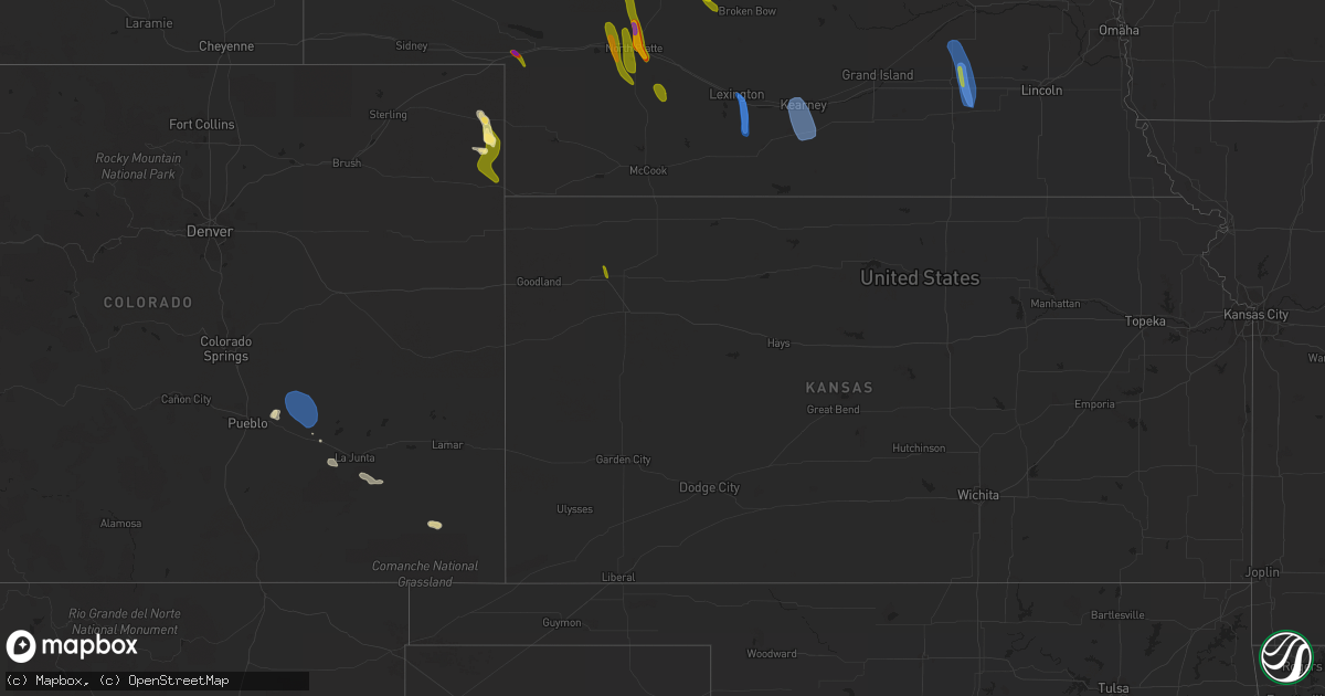
Hail Map in Kansas on July 10, 2023
Get this storm
July 10 map
$229
one time, instant access
Download today. No call, no setup
Keep the $229
Bought the map and want the full workflow? Apply the entire $229 to a subscription within 7 days. None of it is wasted.
Every map, not just this one
This buys you this map. Subscription and you get every map we run, in the markets you choose from a few cities to whole states to nationwide. Plus real-time alerts the moment a storm fires.
Contact data
Name, contact info, occupancy, even credit band for addresses in the footprint. You go from where it hit to who to call.
Become the source they trust
Unlimited branding weather history reports on demand. You already have the documented answer ready for the property owner, and you are the one who showed up with it.
Property data and RoofTrace estimates
Pull up any address you have got, its value and the exact code rules for that jurisdiction, straight from One Click Code. Then RoofTrace estimates the squares, pitch, and roof value, priced the way you price.
Storm reports in Kansas
Kansas
| Date | Description |
|---|---|
| 07/10/20236:56 PM CDT | Mesonet station luek1 ludell 3n. 10m wind gust measurement. |
| 07/10/20236:53 PM CDT | Tallgrass energy awn mesonet station. |
| 07/10/20236:50 PM CDT | Awos station kadt 1 nnw atwood. |
| 07/10/20236:45 PM CDT | Mesonet station gw1727 atwood. |
| 07/09/202311:00 PM CDT | Delayed report. 6 to 10 inch diameter tree limbs downed in town. Observer estimated high winds occurred between 1045pm and 1115pm. |
| 07/09/202310:35 PM CDT | A local report indicates 61 MPH wind near Smith Center Airport |
| 07/09/202310:10 PM CDT | Time estimated from radar. |
| 07/09/202310:09 PM CDT | A local report indicates 61 MPH wind near 8 SSE Glade |
| 07/09/20239:55 PM CDT | Broken power poles in agra. A roof hit a power pole. Power lines down. |
| 07/09/20239:55 PM CDT | Public report relayed via social media of powerlines down. Time estimated based on radar. |
| 07/09/20239:55 PM CDT | Broken power poles in agra. A roof was taken off a building and hit a power pole. Powerlines are down. |
| 07/09/20239:54 PM CDT | Ksu mesonet. |
| 07/09/20237:40 PM CDT | Nickel to quarter sized hail with 10-15 mph winds. |
| 07/09/20237:00 PM CDT | Delayed report. Trained spotter reported estimated 60 mph winds between atwood and midway on highway 36 and between midway and the state line on highway 117. Time is es |
All States Impacted by Hail Map on July 10, 2023
Cities Impacted by Hail Map on July 10, 2023
- Motley, MN
- Staples, MN
- Pillager, MN
- Cushing, MN
- Mesquite, TX
- Balch Springs, TX
- Garland, TX
- Plano, TX
- Sachse, TX
- Richardson, TX
- Dallas, TX
- Allen, TX
- Rowlett, TX
- Wylie, TX
- Winnsboro, TX
- Sunnyvale, TX
- Wagner, SD
- Avon, SD
- Tyndall, SD
- Tabor, SD
- Lake Andes, SD
- Olney Springs, CO
- Ordway, CO
- Boone, CO
- Yoder, CO
- Dante, SD
- Springfield, SD
- Hurley, SD
- Viborg, SD
- Crofton, NE
- Yankton, SD
- Niobrara, NE
- Bloomfield, NE
- Verdigre, NE
- Johnstown, NE
- Purdum, NE
- Thedford, NE
- Halsey, NE
- Mullen, NE
- Seneca, NE
- Winnetoon, NE
- Center, NE
- Davis, SD
- Centerville, SD
- Lennox, SD
- Beresford, SD
- Hudson, SD
- Alcester, SD
- Canton, SD
- Hawarden, IA
- Rock Valley, IA
- Ainsworth, NE
- Brewster, NE
- Irene, SD
- Creighton, NE
- Sioux Center, IA
- Hull, IA
- Dunning, NE
- Tryon, NE
- Holyoke, CO
- Wray, CO
- Boyden, IA
- Orange City, IA
- Arnold, NE
- Sheldon, IA
- Matlock, IA
- George, IA
- Ashton, IA
- Sanborn, IA
- Hermosa, SD
- Melvin, IA
- Plainview, NE
- Wausa, NE
- Magnet, NE
- Mclean, NE
- Randolph, NE
- Hartley, IA
- Hoskins, NE
- Carroll, NE
- Winside, NE
- Fairburn, SD
- Everly, IA
- Osmond, NE
- Anselmo, NE
- Pierce, NE
- Elgin, NE
- Clearwater, NE
- Norfolk, NE
- Oakdale, NE
- Bartlett, NE
- Ocheyedan, IA
- Sibley, IA
- La Junta, CO
- Inwood, IA
- Taylor, NE
- Scotland, SD
- Crystal Falls, MI
- Doon, IA
- Hospers, IA
- Worthing, SD
- Townsend, MT
- Lesterville, SD
- Utica, SD
- Menno, SD
- Van Horn, TX
- Conner, MT
- Sula, MT
- Republic, MI
- Amasa, MI
- Chambers, NE
- Inman, NE
- Oneill, NE
- Ewing, NE
- Amelia, NE
- Woodruff, WI
- Boulder Junction, WI
- Ishpeming, MI
- Gwinn, MI
- Channing, MI
- Foster City, MI
- Iron River, MI
- Winston, MT
- Marquette, MI
- Lac Du Flambeau, WI
- Minocqua, WI
- Springfield, CO
- Manzanola, CO
- Eagle River, WI
- Conover, WI
- Pueblo, CO
- Keystone, SD
- Burwell, NE
- Newcastle, NE
- Rocky Ford, CO
- Buffalo Gap, SD
- Spencer, IA
- Milford, IA
- Lake Park, IA
- Harris, IA
- Fostoria, IA
- Arnolds Park, IA
- Spirit Lake, IA
- Ruthven, IA
- Terril, IA
- Dickens, IA
- Wayne, NE
- Pilger, NE
- Stanton, NE
- Meadow Grove, NE
- Battle Creek, NE
- Petersburg, NE
- North Platte, NE
- Estherville, IA
- Wallingford, IA
- Emmetsburg, IA
- Graettinger, IA
- Ringsted, IA
- Armstrong, IA
- Fenton, IA
- Cylinder, IA
- Whittemore, IA
- Lone Rock, IA
- Algona, IA
- Hudson, WI
- Roberts, WI
- River Falls, WI
- Prior Lake, MN
- Lakeville, MN
- Maxwell, NE
- Beldenville, WI
- Sheldon, WI
- Holcombe, WI
- Conrath, WI
- Hawkins, WI
- Glen Flora, WI
- Hershey, NE
- Lexington, NE
- Albert Lea, MN
- Bertrand, NE
- Smithfield, NE
- Dundas, MN
- Lonsdale, MN
- Faribault, MN
- Northfield, MN
- Curtis, NE
- Callaway, NE
- Merna, NE
- Wellfleet, NE
- Brule, NE
- Venango, NE
- Saint Germain, WI
- Sayner, WI
- Bruce, WI
- Ladysmith, WI
- Weyerhaeuser, WI
- Mankato, MN
- Eagle Lake, MN
- Skandia, MI
- York, NE
- Stromsburg, NE
- Waco, NE
- Benedict, NE
- Medford, MN
- Owatonna, MN
- Axtell, NE
- Kearney, NE
- Funk, NE
- Minden, NE
- Exeter, NE
- Osceola, NE
- McCool Junction, NE
- Gresham, NE
- Beaver Crossing, NE
- Bloomington, NE
- Waterville, WA
- Tripp, SD
- Marienthal, KS
- Leoti, KS
- Farmington, MN
- Newberry, MI
- McMillan, MI
- Germfask, MI
- Gulliver, MI
- Gould City, MI
- Champion, MI
- Naponee, NE
- Waseca, MN
- Hayward, WI
- Joplin, MT
- Athol, ID
- Bryant, WI
- Antigo, WI
- Millsap, TX
- Butternut, WI
- Mercer, WI
- Iron Mountain, MI
- Yeso, NM
- Wetmore, MI
- Munising, MI
- Beaver City, NE
- Oxford, NE
- Ledyard, IA
- Swea City, IA
- Seney, MI
- Good Thunder, MN
- Mapleton, MN
- Lake Crystal, MN
- Caspian, MI
- Gaastra, MI
- Rhinelander, WI
- Lake Tomahawk, WI
- Three Lakes, WI
- Saint Peter, MN
- Kasota, MN
- Lakota, IA
- Bancroft, IA
- Rathdrum, ID
- Sault Sainte Marie, MI
- Dafter, MI
- Brimley, MI
- Elk, WA
- Newport, WA
- Blanchard, ID
- Chattaroy, WA
- Spirit Lake, ID
- Saint Edward, NE
- Alden, MN
- Elwood, NE
- Hastings, MN
- Catawba, WI
- Kennan, WI
- Deer Park, WA
- Tumtum, WA
- Wellpinit, WA
- Ford, WA
- Albion, NE
- Hayden, ID
- Las Animas, CO
- Weatherford, TX
- Iredell, TX
- Sagola, MI
- Trenton, NE
- Culbertson, NE
- Chatham, MI
- Trenary, MI
- Rapid River, MI
- Prairie Farm, WI
- Dallas, WI
- Spring Valley, WI
- Tripoli, WI
- Hazelhurst, WI
- Harshaw, WI
- Stockton, KS
- Sutherland, NE
- Granada, CO
- Holly, CO
- Lovington, NM
- Farnam, NE
- Stapleton, NE
- Broken Bow, NE
- Oconto, NE
- Tony, WI
- Lake Charles, LA
- Eckerman, MI
- Hulbert, MI
- Kinross, MI
- Grand Marais, MI
- Perkasie, PA
- Silver Creek, NE
- Colfax, WI
- Lipan, TX
- Stephenville, TX
- Weskan, KS
- Tribune, KS
- Manitowish Waters, WI
- New Auburn, WI
- Clayton, WA
- Genoa, NE
- Leland, IA
- Maywood, NE
- Ericson, NE
- Snyder, TX
- Morristown, MN
- Covington, MI
- Michigamme, MI
- Watton, MI
- Elko New Market, MN
- Marathon, WI
- Athens, WI
- Merrill, WI
- Buffalo Center, IA
- Plains, TX
- Kenyon, MN
- West Concord, MN
- Pickerel, WI
- Shingleton, MI
- Manistique, MI
- Edson, KS
- Brewster, KS
- Friend, NE
- New Prague, MN
- Neligh, NE
- Whitlash, MT
- Franklin, NE
- Kensington, KS
- Riverton, NE
- Campbell, NE
- Upland, NE
- Hildreth, NE
- Glenville, MN
- Dolliver, IA
- Ellsworth, WI
- Bay City, WI
- Stone Lake, WI
- Springbrook, WI
- Hico, TX
- Hamlin, TX
- Rock, MI
- Roby, TX
- Ceylon, MN
- Dunnell, MN
- Phillips, WI
- Lakeland, MN
- Hammond, WI
- Afton, MN
- Baldwin, WI
- Stillwater, MN
- Prescott, WI
- Fairfax, SD
- Madison, NE
- Pickstown, SD
- Long Lake, WI
- Paxton, NE
- Warsaw, MN
- Engadine, MI
- Welch, MN
- Hartline, WA
- Aspermont, TX
- Rotan, TX
- Brunswick, NE
- Republican City, NE
- Alma, NE
- Hanlontown, IA
- Lake Mills, IA
- Northwood, IA
- Kensett, IA
- Joice, IA
- Amherst, CO
- Cleburne, TX
- Granbury, TX
- Rainbow, TX
- Land O'Lakes, WI
- Wausau, WI
- Quakertown, PA
- Richlandtown, PA
- Atwood, KS
- Colby, KS
- Primghar, IA
- Ottsville, PA
- Doylestown, PA
- Pipersville, PA
- Phelps, WI
- Bloomer, WI
- Hampton, MN
- Boise City, OK
- Felt, OK
- Levant, KS
- Walsh, CO
- Two Buttes, CO
- Jayton, TX
- Holdrege, NE
- Wilcox, NE
- Park Falls, WI
- Cornell, WI
- Wilson, WI
- New Richmond, WI
- Woodville, WI
- Glen Rose, TX
- Dalhart, TX
- Prentice, WI
- Arapahoe, NE
- Webster, MN
- Pearson, WI
- Waterville, MN
- Janesville, MN
- Little Lake, MI
- McCook, NE
- Phillipsburg, KS
- Edgar, WI
- Rule, TX
- Stamford, TX
- Knapp, WI
- Menomonie, WI
- Elysian, MN
- Sweetwater, TX
- Florence, WI
- Maiden Rock, WI
- Hager City, WI
- Watersmeet, MI
- Lebanon, KS
- Smith Center, KS
- Boyceville, WI
- Riverdale, NE
- Amherst, NE
- Westlake, LA
- Minnesota Lake, MN
- Thompson, IA
- Forest City, IA
- Cornell, MI
- Star Lake, WI
- Stratton, NE
- Larchwood, IA
- Madison Lake, MN
- Iowa, LA
- Brady, NE
- Moorefield, NE
- Oakwood, OK
- Taloga, OK
- Seiling, OK
- Putnam, OK
- Canton, OK
- Custer City, OK
- Thomas, OK
- Shawnee, OK
- Edmond, OK
- Oklahoma City, OK
- Yukon, OK
- Ada, OK
- Ralls, TX
- Wolfforth, TX
- Lorenzo, TX
- Shallowater, TX
- Lubbock, TX
- Slaton, TX
- Ransom Canyon, TX
- Davis, OK
- Sulphur, OK
- Hinton, OK
- Lookeba, OK
- Calumet, OK
- Weatherford, OK
- Union City, OK
- Anadarko, OK
- Clinton, OK
- Binger, OK
- Colony, OK
- Hydro, OK
- Arapaho, OK
- Corn, OK
- Gracemont, OK
- Minco, OK
- El Reno, OK
- Foss, OK
- Geary, OK
- Harrah, OK
- Earlsboro, OK
- Wellston, OK
- Luther, OK
- Meeker, OK
- Mcloud, OK
- Jones, OK
- Tecumseh, OK
- Mustang, OK
- Pocasset, OK
- Tuttle, OK
- Asher, OK
- Maud, OK
- Macomb, OK
- Seminole, OK
- Konawa, OK
- Blanchard, OK
- Newcastle, OK
- Amber, OK
- Wilson, TX
- Meadow, TX
- Ropesville, TX
- Tahoka, TX
- Spur, TX
- Winona, MN
- Dustin, OK
- Elmore, MN
- Ellinwood, KS
- Trempealeau, WI
- Park, KS
- Guthrie, OK
- Edison, NE
- Perkins, MI
- Gladstone, MI
- Arcadia, OK
- Zumbrota, MN
- Oronoco, MN
- Pine Island, MN
- Canadian, TX
- Miami, TX
- Chandler, OK
- Crosbyton, TX
- Plevna, KS
- Sylvia, KS
- Collyer, KS
- Utica, KS
- Cottage Grove, WI
- Stoughton, WI
- Cambridge, WI
- Nine Mile Falls, WA
- Springdale, WA
- Elton, WI
- White Lake, WI
- Pauls Valley, OK
- Stratford, OK
- Wynnewood, OK
- Roff, OK
- Prague, OK
- Rosemount, MN
- Leedey, OK
- Mineral Wells, TX
- Agra, KS
- Burlington, CO
- Orleans, NE
- Arapahoe, CO
- Kingfisher, OK
- Galesville, WI
- Cashion, OK
- Hennessey, OK
- Eustis, NE
- Wells, MN
- Calvin, OK
- Centrahoma, OK
- Allen, OK
- Tupelo, OK
- Junction City, WI
- Crescent, OK
- Rumely, MI
- Madison, WI
- Bowler, WI
- Aniwa, WI
- Milladore, WI
- Stevens Point, WI
- Rudolph, WI
- Deerton, MI
- Bogue, KS
- Great Bend, KS
- Okarche, OK
- Dublin, TX
- Stuart, OK
- Weleetka, OK
- Custer, WI
- Rosholt, WI
- Piedmont, OK
- Okeene, OK
- Holdenville, OK
- Holbrook, NE
- Ettrick, WI
- Hudson, KS
- Scott City, KS
- Lenora, KS
- Logan, KS
- Hayward, MN
- Ransom, KS
- Brownell, KS
- Welcome, MN
- Fairmont, MN
- Blooming Prairie, MN
- Hoisington, KS
- Hitchcock, OK
- Mazeppa, MN
- Zumbro Falls, MN
- Eben Junction, MI
- Blue Earth, MN
- Granada, MN
- Arcadia, WI
- Dodge, WI
- Claremont, MN
- Bessie, OK
- Benton, LA
- Loyal, OK
- Plainville, KS
- Okemah, OK
- Nerstrand, MN
- Montgomery, MN
- Lake City, MN
- Millville, MN
- Clayton, KS
- Butler, OK
- Fountain City, WI
- Paden, OK
- Overton, NE
- Longdale, OK
- Goodhue, MN
- Kellogg, MN
- Washington, OK
- Cordell, OK
- Wetumka, OK
- Sharon Springs, KS
- Spencer, OK
- Choctaw, OK
- Woodward, OK
- Newalla, OK
- Purcell, OK
- Sundance, WY
- Devils Tower, WY
- Moorcroft, WY
- Omega, OK
- Byars, OK
- Sasakwa, OK
- Arthur City, TX
- Sumner, TX
- Wayne, OK
- Paoli, OK
- Stringtown, OK
- Beulah, WY
- Mcfarland, WI
- Deerfield, WI
- Bokchito, OK
- Arnett, OK
- Fitzhugh, OK
- Gate, OK
- Rosston, OK
- Stonewall, OK
- Wewoka, OK
- Sharon, OK
- Coleman, OK
- Norman, OK
- Atwood, OK
- Palisades, WA
- Bark River, MI
- Negaunee, MI
- Fountainville, PA
- Dublin, PA


