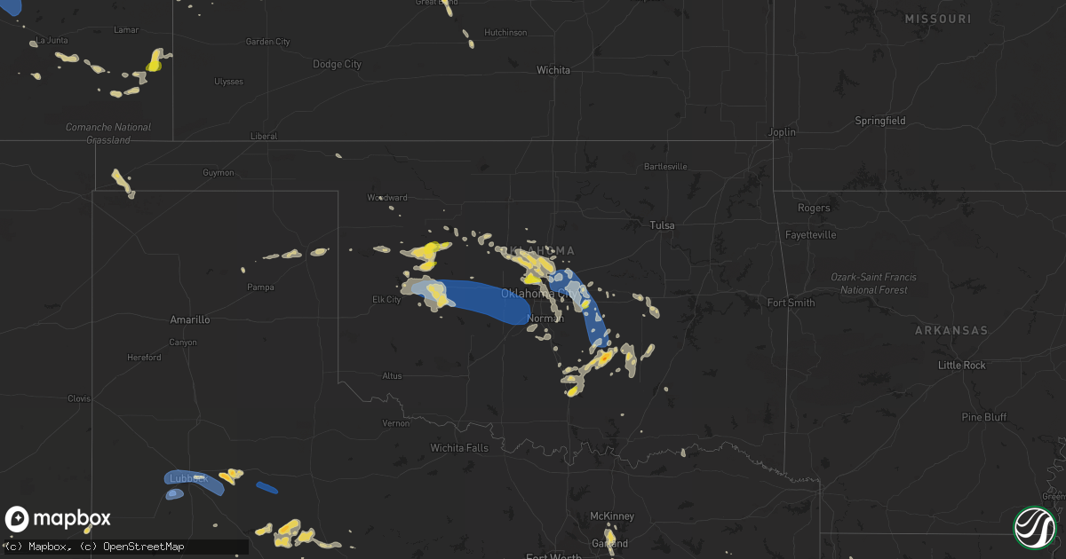
Hail Map on July 10, 2023
Get this storm
July 10 map
$229
one time, instant access
Download today. No call, no setup
Keep the $229
Bought the map and want the full workflow? Apply the entire $229 to a subscription within 7 days. None of it is wasted.
Every map, not just this one
This buys you this map. Subscription and you get every map we run, in the markets you choose from a few cities to whole states to nationwide. Plus real-time alerts the moment a storm fires.
Contact data
Name, contact info, occupancy, even credit band for addresses in the footprint. You go from where it hit to who to call.
Become the source they trust
Unlimited branding weather history reports on demand. You already have the documented answer ready for the property owner, and you are the one who showed up with it.
Property data and RoofTrace estimates
Pull up any address you have got, its value and the exact code rules for that jurisdiction, straight from One Click Code. Then RoofTrace estimates the squares, pitch, and roof value, priced the way you price.
States Impacted by Hail Map on July 10, 2023
Storm reports
Pennsylvania
| Date | Description |
|---|---|
| 07/10/20236:26 PM CDT | Trees and wires down across the township. |
| 07/10/20236:26 PM CDT | Trees and wires down. |
| 07/10/20236:26 PM CDT | Additional details: trees and wires down across the township - heavy concentration at geddes way near potters lane. |
| 07/10/20236:23 PM CDT | Trees and wires down. |
| 07/10/20236:22 PM CDT | Multiple trees down on creamery road. Report via social media. Time estimated from radar. |
| 07/10/20236:20 PM CDT | Several trees uprooted at a residence on sterner mill road. Power out. Report via social media. Time estimated from radar. |
| 07/10/20236:20 PM CDT | Multiple trees down at a residence on east rock road near dublin pike. Power out. Report via social media. Time estimated from radar. |
| 07/10/20236:20 PM CDT | Trees down. Time estimated from radar. |
| 07/10/20236:16 PM CDT | A severe thunderstorm produced a widespread area of somewhat sporadic straight line wind damage. A survey team found damage beginning in northeast portion of east rockh |
| 07/10/20236:15 PM CDT | Report from mping: trees uprooted or snapped. |
| 07/10/20236:14 PM CDT | Report from mping: quarter |
Nebraska
| Date | Description |
|---|---|
| 07/10/20236:55 PM CDT | Caller estimated up to 60 mph winds. |
| 07/10/20236:55 PM CDT | Estimated quarter sized hail. Time estimated via radar. |
| 07/10/20236:50 PM CDT | A local report indicates 2.00 inch wind near 4 N North Platte |
| 07/10/20236:48 PM CDT | Baseball size hail... Possibly larger. |
| 07/10/20236:33 PM CDT | A local report indicates 2.75 inch wind near 11 N North Platte |
| 07/10/20236:29 PM CDT | A local report indicates 59 MPH wind near Broken Bow |
| 07/10/20236:15 PM CDT | Spotter shared picture on social media of healthy tree limb around 6 inches in diameter down on truck. |
| 07/10/20235:37 PM CDT | A local report indicates 60 MPH wind near 11 ENE Arnold |
| 07/10/20235:30 PM CDT | Additional information... Roof blown off elementary school... Which was blown into the high school and damaged it as well. Numerous trees uprooted across town. Numerous |
| 07/10/20235:30 PM CDT | Emergency management passed along report and photo of the plainview elementary school roof being torn off. Time estimated based on radar data. |
| 07/10/20235:14 PM CDT | A local report indicates 1.25 inch wind near Bazile Mills |
| 07/10/20235:08 PM CDT | Trees leaning against power lines near highway 20. |
| 07/10/20235:06 PM CDT | Relayed report from trained spotter. |
| 07/10/20235:00 PM CDT | Measured gust on a personal weather station. |
| 07/10/20234:57 PM CDT | A local report indicates 1.00 inch wind near 13 S Thedford |
| 07/10/20234:51 PM CDT | Several very large tree limbs down greater than 1 foot in diameter. |
| 07/10/20234:46 PM CDT | Streets are impassable due to the number of large trees down. |
| 07/10/20234:45 PM CDT | A local report indicates 1.25 inch wind near 9 NNW Brewster |
| 07/10/20234:44 PM CDT | A local report indicates 1.25 inch wind near Center |
| 07/10/20234:43 PM CDT | Social media photo of steeple ripped off of a church. Also several photos of snapped trees. Time estimated from radar. |
| 07/10/20234:38 PM CDT | A local report indicates 1.50 inch wind near 1 SSE Center |
| 07/10/20234:31 PM CDT | Large trees blown down. |
| 07/10/20234:12 PM CDT | Hail was larger than a golf ball but smaller than a tennis ball. |
| 07/10/20234:05 PM CDT | Hail is larger than a quarter and smaller than a golf ball. |
| 07/10/20234:05 PM CDT | A local report indicates 1.75 inch wind near 2 W Niobrara |
| 07/10/20234:04 PM CDT | A local report indicates 60 MPH wind near 3 ESE Seneca |
| 07/10/20234:00 PM CDT | A local report indicates 1.00 inch wind near 3 E Seneca |
| 07/09/20239:32 PM CDT | Report from mping: quarter |
| 07/09/20239:28 PM CDT | A local report indicates 67 MPH wind near 4 NW Huntley |
| 07/09/20239:22 PM CDT | Trained spotter reported quarter size hail on the north side of town. |
| 07/09/20239:20 PM CDT | Corrects time of previous tstm wnd dmg report from alma. Delayed report. Multiple reports via social media of large tree limbs downed in alma. Time estimated from radar |
| 07/09/20239:20 PM CDT | Corrects previous tstm wnd dmg report from 1 w waco. Irrigation pivot blown over and severely damaged. Extensive hail and wind damage to crops observed. Damage to a gra |
| 07/09/20239:20 PM CDT | Report on social media of grain bins destroyed 3 s of waco. |
| 07/09/20239:20 PM CDT | Irrigation pivot blown over and severely damaged. Extensive hail and wind damage to crops observed. |
| 07/09/20239:20 PM CDT | Unknown number of semi trucks overturned on interstate 80 near mile marker 360. Time estimated based on radar. |
| 07/09/20239:15 PM CDT | Trained spotter reported 65 to 70 mph wind gusts. Winds pushed a grill with locked wheels 2 feet. Power is out at spotters location. Also reported dime to nickel size h |
| 07/09/20239:11 PM CDT | Corrects previous tstm wnd gst report from 4 nw huntley. |
| 07/09/20239:10 PM CDT | Small tree branches down along with dime sized hail. |
| 07/09/20239:00 PM CDT | Measured with handheld... 64 mph winds. |
| 07/09/20238:50 PM CDT | Peak gust from home weather station. |
| 07/09/20238:25 PM CDT | Delayed report via social media of 4 to 6 inch tree limbs downed at this location. Time estimated from radar. |
| 07/09/20238:20 PM CDT | Delayed report. Multiple reports via social media of large tree limbs downed in alma. Time estimated from radar. |
| 07/09/20238:17 PM CDT | A local report indicates 71 MPH wind near 3 NE Smithfield |
| 07/09/20238:11 PM CDT | A local report indicates 58 MPH wind near 3 SW Kearney |
| 07/09/20238:11 PM CDT | Measured on home weather station. The wind gust bent his flag pole. |
| 07/09/20238:11 PM CDT | Report of a downed tree limb approximately 6 inches in diameter in southwest kearney. |
| 07/09/20238:06 PM CDT | A local report indicates 59 MPH wind near 1 W Kearney |
| 07/09/20238:00 PM CDT | A local report indicates 60 MPH wind near Lexington |
| 07/09/20237:47 PM CDT | A local report indicates 1.75 inch wind near Hershey |
| 07/09/20237:47 PM CDT | A local report indicates 1.75 inch wind near Hershey |
| 07/09/20237:31 PM CDT | A local report indicates 1.25 inch wind near 3 W North Platte |
| 07/09/20237:15 PM CDT | A local report indicates 1.75 inch wind near North Platte |
| 07/09/20237:14 PM CDT | A local report indicates 1.50 inch wind near 1 NNW North Platte |
| 07/09/20237:13 PM CDT | A local report indicates 1.75 inch wind near 3 ENE North Platte |
| 07/09/20237:11 PM CDT | Mping report. |
| 07/09/20237:11 PM CDT | Mping report |
| 07/09/20237:11 PM CDT | Mping report |
| 07/09/20237:10 PM CDT | A local report indicates 2.50 inch wind near 1 ENE North Platte |
| 07/09/20237:06 PM CDT | A local report indicates 1.00 inch wind near 1 SE North Platte |
| 07/09/20237:03 PM CDT | A local report indicates 1.50 inch wind near 5 NNE North Platte |
| 07/09/20237:03 PM CDT | Tree limbs were also knocked down. |
| 07/09/20237:02 PM CDT | A local report indicates 2.50 inch wind near 3 W Brule |
| 07/09/20237:00 PM CDT | A local report indicates 1.75 inch wind near 2 WSW Brule |
Oklahoma
| Date | Description |
|---|---|
| 07/10/20234:25 AM CDT | 12 to 24 inch diameter tree limb down... Blocking portions of highway 29. Time estim |
| 07/10/20234:25 AM CDT | 12 to 24 inch diameter tree limb down... Blocking portions of highway 29. Time estimated via radar. |
| 07/10/20234:24 AM CDT | Report from mping: trees uprooted or snapped; roof blown off. |
| 07/10/20234:20 AM CDT | Large |
| 07/10/20234:15 AM CDT | A local report indicates 66 MPH wind near 4 NNE Sulphur |
| 07/10/20234:05 AM CDT | Trees and powerlines down in byng. Roof and garage door damage. |
| 07/10/20233:22 AM CDT | A local report indicates 72 MPH wind near 1 SSE Tinker Air Force |
| 07/10/20233:15 AM CDT | Minco mesonet. |
| 07/10/20232:50 AM CDT | At norman mesonet site. Norman awos recorded 47 kt gust as well. |
| 07/10/20232:43 AM CDT | A local report indicates 1.50 inch wind near 3 NW Ada |
| 07/10/20232:30 AM CDT | Hinton mesonet site. |
| 07/10/20232:30 AM CDT | A local report indicates 64 MPH wind near 3 NNW Shawnee |
| 07/10/20232:25 AM CDT | A local report indicates 60 MPH wind near 3 NW The Village |
| 07/10/20232:14 AM CDT | A local report indicates 1.00 inch wind near 5 NW The Village |
| 07/10/20232:14 AM CDT | A local report indicates 1.00 inch wind near 6 WNW The Village |
| 07/10/20232:14 AM CDT | A local report indicates 1.25 inch wind near 4 W Edmond |
| 07/10/20232:14 AM CDT | A local report indicates 60 MPH wind near Weatherford |
| 07/10/20232:10 AM CDT | A local report indicates 1.00 inch wind near 6 E Piedmont |
| 07/10/20231:52 AM CDT | A local report indicates 1.00 inch wind near Shawnee |
| 07/10/20231:38 AM CDT | Powerlines down in vicinity of 122nd/memorial on penn. Time estimated by radar. |
Minnesota
| Date | Description |
|---|---|
| 07/09/20239:25 PM CDT | Report from twitter. |
| 07/09/20239:00 PM CDT | Relayed via chat. |
| 07/09/20238:52 PM CDT | Phone report. |
| 07/09/20238:26 PM CDT | Phone report. |
| 07/09/20238:14 PM CDT | Report from mping: quarter |
| 07/09/20237:36 PM CDT | Photo relayed via social media. |
| 07/09/20237:20 PM CDT | Photo relayed via social media with measuring tape. |
| 07/09/20237:19 PM CDT | Photo relayed via twitter. |
| 07/09/20237:11 PM CDT | Metro skywarn phone report. |
Colorado
| Date | Description |
|---|---|
| 07/10/20236:18 PM CDT | A local report indicates 1.00 inch wind near 12 NE Two Buttes |
Michigan
| Date | Description |
|---|---|
| 07/10/20236:20 PM CDT | Picture on twitter of hail stone measuremnet just under 3 cm ie 1 inch. |
| 07/10/20236:15 PM CDT | Social media report showing a picture of a hailstone that was estimated to be quarter sized near johnson lake. Time estimated by radar. |
| 07/10/20236:13 PM CDT | Report with picture. |
| 07/10/20236:10 PM CDT | A local report indicates 1.00 inch wind near 1 NW Little Lake |
| 07/10/20236:00 PM CDT | A local report indicates 2.00 inch wind near 1 WSW Traunik |
| 07/10/20235:45 PM CDT | Social media photo of hail slightly larger than an adjacent quarter observed towards the end of cr 581. Time estimated by radar. |
| 07/10/20235:35 PM CDT | Picture report on facebook. |
| 07/10/20235:30 PM CDT | Facebook comment on wjmn local 3s post. Time estimated by radar. |
| 07/09/20238:45 PM CDT | Power out on the northwest side of big manistique lake. Two cell towers on the north side of the lake are also out. Time of wind damage estimated by radar. From faceboo |
| 07/09/20237:52 PM CDT | Fire chief reports quarter sized hail at 6 mile road and east birch point trail. Time estimated by radar. |
| 07/09/20237:30 PM CDT | Trained spotter reports small trees downed on mcneary lake. Time estimated by radar. |
| 07/09/20237:08 PM CDT | Dozens of trees snapped and uprooted. |
| 07/09/20237:00 PM CDT | Several trees down. Camper windows blown out. |
Montana
| Date | Description |
|---|---|
| 07/10/20236:57 PM CDT | A local report indicates 63 MPH wind near 3 ENE Livingston |
| 07/10/20236:54 PM CDT | Mesonet station ekhm8 elkhorn raws - 8 w townsend. |
| 07/10/20236:44 PM CDT | Measured at site kmtulm7. |
| 07/10/20236:43 PM CDT | Mesonet station mtdpc deep creek us12 mp 23.5. |
| 07/10/20236:40 PM CDT | Air temp went from 90 to 72 degrees. Via ambient weather. |
| 07/10/20236:20 PM CDT | A downed tree... Taking out a power pole was shared on social media on excelsior ave in butte... Mt. Time of the damage is estimated. A wind gust of 47mph was observed |
| 07/10/20236:15 PM CDT | Mesonet station ginm8 ginger raws. Time is estimate of occurrence. Finalized time will be determined in storm data. |
| 07/09/20238:30 PM CDT | A local report indicates 59 MPH wind near 5 N Rapleje |
| 07/09/20238:12 PM CDT | A local report indicates 64 MPH wind near 17 NE Wilsall |
| 07/09/20237:01 PM CDT | A local report indicates 65 MPH wind near 6 ENE Livingston |
Washington
| Date | Description |
|---|---|
| 07/10/20236:30 PM CDT | Crop damage reported in areas around harline from wind and flooding. Time estimated from radar. Hail to dime size also reported. |
| 07/10/20236:12 PM CDT | Downed power lines and power outages north of wilbur. Time estimated from radar. |
| 07/10/20235:53 PM CDT | Multiple reports of crop damage from wind... Hail... And flooding between hartline and almira. Time estimated from radar. |
| 07/10/20235:34 PM CDT | Several reports of crop damage from hail and flooding between waterville and coulee city. Hail ranged from penny to quarter size in this corridor. Time estimated from r |
| 07/09/20238:57 PM CDT | Time estimated from radar. |
| 07/09/20238:50 PM CDT | Facebook picture of hailstones varying from dimes to quarters to half dollars. |
| 07/09/20238:34 PM CDT | Downed tree limbs from a combination of wind and hail. Hail up to penny size also reported. Time estimated from radar. |
| 07/09/20237:50 PM CDT | Facebook picture of damaged roofing panels. Time estimated from radar. |
Texas
| Date | Description |
|---|---|
| 07/10/20236:14 PM CDT | Em reporting getting dispatched for an empty 18 wheeler blown over on hwy 84 and hwy 180. Estimated winds speeds of 60+mph. |
| 07/10/20233:30 PM CDT | Mesonet station twb49 11.2 ne van horn |
| 07/09/202311:23 PM CDT | A local report indicates 68 MPH wind near 1 W Spur |
| 07/09/202311:11 PM CDT | A local report indicates 63 MPH wind near 3 WNW Lubbock |
| 07/09/202310:52 PM CDT | A local report indicates 76 MPH wind near 6 S Wolfforth |
South Dakota
| Date | Description |
|---|---|
| 07/10/20235:18 PM CDT | Mainly half inch size hail |
| 07/10/20234:29 PM CDT | A local report indicates 1.25 inch wind near Hudson |
| 07/10/20234:10 PM CDT | Report via social media. Time estimated by radar. |
| 07/10/20234:00 PM CDT | A local report indicates 1.00 inch wind near 4 NNW Viborg |
| 07/10/20233:52 PM CDT | A local report indicates 1.00 inch wind near Viborg |
| 07/10/20233:49 PM CDT | A local report indicates 1.75 inch wind near 10 W Springfield |
| 07/10/20233:49 PM CDT | Corrects previous hail report from 8 w springfield. |
| 07/10/20233:43 PM CDT | Damaging winds took the roof off of a dairy. |
| 07/10/20233:41 PM CDT | A local report indicates 1.00 inch wind near 8 W Springfield |
| 07/10/20233:35 PM CDT | A local report indicates 1.00 inch wind near 4 ESE Tabor |
| 07/10/20233:25 PM CDT | Multiple healthy trees uprooted. Time estimated from radar. |
| 07/10/20233:24 PM CDT | Personal weather station measured a wind gust to 76 mph. Time estimated from radar. |
| 07/10/20233:16 PM CDT | Delayed report from social media. Time estimated by radar. |
| 07/10/20232:54 PM CDT | Mostly nickel to dime size hail... But the largest stones were the size of a quarter. Time estimated from radar. |
Kansas
| Date | Description |
|---|---|
| 07/10/20236:56 PM CDT | Mesonet station luek1 ludell 3n. 10m wind gust measurement. |
| 07/10/20236:53 PM CDT | Tallgrass energy awn mesonet station. |
| 07/10/20236:50 PM CDT | Awos station kadt 1 nnw atwood. |
| 07/10/20236:45 PM CDT | Mesonet station gw1727 atwood. |
| 07/09/202311:00 PM CDT | Delayed report. 6 to 10 inch diameter tree limbs downed in town. Observer estimated high winds occurred between 1045pm and 1115pm. |
| 07/09/202310:35 PM CDT | A local report indicates 61 MPH wind near Smith Center Airport |
| 07/09/202310:10 PM CDT | Time estimated from radar. |
| 07/09/202310:09 PM CDT | A local report indicates 61 MPH wind near 8 SSE Glade |
| 07/09/20239:55 PM CDT | Public report relayed via social media of powerlines down. Time estimated based on radar. |
| 07/09/20239:55 PM CDT | Broken power poles in agra. A roof was taken off a building and hit a power pole. Powerlines are down. |
| 07/09/20239:55 PM CDT | Broken power poles in agra. A roof hit a power pole. Power lines down. |
| 07/09/20239:54 PM CDT | Ksu mesonet. |
| 07/09/20237:40 PM CDT | Nickel to quarter sized hail with 10-15 mph winds. |
| 07/09/20237:00 PM CDT | Delayed report. Trained spotter reported estimated 60 mph winds between atwood and midway on highway 36 and between midway and the state line on highway 117. Time is es |
Florida
| Date | Description |
|---|---|
| 07/10/202311:29 AM CDT | Tree reported down caused by thunderstorm winds. |
| 07/10/202311:25 AM CDT | Tree was downed at the intersection of buccaneer trail and 1st coast highway. Time estimate based on radar. |
| 07/10/202311:00 AM CDT | Mesonet station 1323w 1.3 se jacksonville |
| 07/10/202310:50 AM CDT | Tree down off lem turner road near jax airport. Time estimated by radar. |
| 07/10/202310:40 AM CDT | Tree down blocking the road near haddock drive/haddock rd. Time estimated by radar. |
| 07/10/20237:37 AM CDT | Tree limb fell on a power line resulting in a power outage along orange ave between jim lee road and s monroe street. |
| 07/10/20237:15 AM CDT | A tree limb fell onto power lines and resulted in a power outage in the lake talquin area. |
Wisconsin
| Date | Description |
|---|---|
| 07/10/20236:58 PM CDT | Phone report. |
| 07/10/20236:52 PM CDT | Phone report. |
| 07/10/20236:45 PM CDT | Photo relayed via news station. |
| 07/10/20236:24 PM CDT | Photo sent to news station. |
| 07/10/20236:14 PM CDT | Near kentuck lake. |
| 07/10/20236:10 PM CDT | Photo relayed via twitter. |
| 07/10/20236:08 PM CDT | A local report indicates 1.00 inch wind near 4 E Weyerhaeuser |
| 07/10/20236:06 PM CDT | Photo relayed via social media. |
| 07/10/20236:03 PM CDT | Hail ranging from pea size up to quarter size. Time estimated from radar. |
| 07/10/20236:00 PM CDT | Delayed report. |
| 07/10/20235:52 PM CDT | A local report indicates 1.00 inch wind near 3 W Eagle River |
| 07/09/202310:46 PM CDT | Report from mping: 1-inch tree limbs broken; shingles blown off. |
| 07/09/202310:18 PM CDT | Large tree limb down along us highway 53. |
| 07/09/20237:20 PM CDT | 10 inch diameter tree snapped off from winds. |
| 07/09/20237:13 PM CDT | Phone report. |
| 07/09/20237:03 PM CDT | Phone report... Two separate hail bursts with this one being the larger of the two. |
Iowa
| Date | Description |
|---|---|
| 07/10/20236:34 PM CDT | A local report indicates 1.00 inch wind near 3 NE Estherville |
| 07/10/20236:29 PM CDT | Asos station kest estherville airport. |
| 07/10/20236:18 PM CDT | Power pole leaning over and large tree branches broken off. Time estimated by radar. |
| 07/10/20236:16 PM CDT | Time estimated by radar. |
| 07/10/20236:16 PM CDT | Forwarded from gruver fd. Time estimated. |
| 07/10/20236:14 PM CDT | Report from mesonet station kiaterri4 west of terril. |
| 07/10/20236:14 PM CDT | Corrects previous tstm wnd gst report from 3 sw terril. Measured wind gust by personal weather station. |
| 07/10/20236:10 PM CDT | Time estimated by radar. |
| 07/10/20236:10 PM CDT | Measured wind gust by personal weather station. |
| 07/10/20235:54 PM CDT | Large tree branch over the road. |
| 07/10/20235:43 PM CDT | Also with dime size hail. |
| 07/10/20235:30 PM CDT | Roof of outbuilding was tossed 200 yards. Large walnut tree broken off. |
| 07/10/20235:21 PM CDT | Report from mping: quarter |
| 07/10/20235:21 PM CDT | Hail ranging in size from pea to golf ball size. Tree limbs 2-3 inches in diamater also downed. |
| 07/10/20235:19 PM CDT | Report from mping: half dollar |
| 07/10/20235:15 PM CDT | A local report indicates 1.75 inch wind near 4 NNE Sheldon |
| 07/10/20235:15 PM CDT | A local report indicates 60 MPH wind near 4 NNE Sheldon |
| 07/10/20235:11 PM CDT | A local report indicates 1.00 inch wind near Matlock |
| 07/10/20234:48 PM CDT | 50 mph winds also observed. |
| 07/10/20234:42 PM CDT | Multiple 3-4 inch tree limbs downed. |
Idaho
| Date | Description |
|---|---|
| 07/09/20239:34 PM CDT | Downed trees and wires near kelso lake road. Time estimated from radar. |
| 07/09/20239:29 PM CDT | Downed trees and wires near barrett road. Time estimated from radar. |
| 07/09/20239:16 PM CDT | Time estimated from radar. |
| 07/09/20239:16 PM CDT | Corrects previous hail report from blanchard. Facebook picture of one inch hail. Time corrected based on radar data. |
| 07/09/20239:10 PM CDT | Facebook picture of one inch hail. |
Cities Impacted by Hail Map on July 10, 2023
- Motley, MN
- Staples, MN
- Pillager, MN
- Cushing, MN
- Mesquite, TX
- Balch Springs, TX
- Garland, TX
- Plano, TX
- Sachse, TX
- Richardson, TX
- Dallas, TX
- Allen, TX
- Rowlett, TX
- Wylie, TX
- Winnsboro, TX
- Sunnyvale, TX
- Wagner, SD
- Avon, SD
- Tyndall, SD
- Tabor, SD
- Lake Andes, SD
- Olney Springs, CO
- Ordway, CO
- Boone, CO
- Yoder, CO
- Dante, SD
- Springfield, SD
- Hurley, SD
- Viborg, SD
- Crofton, NE
- Yankton, SD
- Niobrara, NE
- Bloomfield, NE
- Verdigre, NE
- Johnstown, NE
- Purdum, NE
- Thedford, NE
- Halsey, NE
- Mullen, NE
- Seneca, NE
- Winnetoon, NE
- Center, NE
- Davis, SD
- Centerville, SD
- Lennox, SD
- Beresford, SD
- Hudson, SD
- Alcester, SD
- Canton, SD
- Hawarden, IA
- Rock Valley, IA
- Ainsworth, NE
- Brewster, NE
- Irene, SD
- Creighton, NE
- Sioux Center, IA
- Hull, IA
- Dunning, NE
- Tryon, NE
- Holyoke, CO
- Wray, CO
- Boyden, IA
- Orange City, IA
- Arnold, NE
- Sheldon, IA
- Matlock, IA
- George, IA
- Ashton, IA
- Sanborn, IA
- Hermosa, SD
- Melvin, IA
- Plainview, NE
- Wausa, NE
- Magnet, NE
- Mclean, NE
- Randolph, NE
- Hartley, IA
- Hoskins, NE
- Carroll, NE
- Winside, NE
- Fairburn, SD
- Everly, IA
- Osmond, NE
- Anselmo, NE
- Pierce, NE
- Elgin, NE
- Clearwater, NE
- Norfolk, NE
- Oakdale, NE
- Bartlett, NE
- Ocheyedan, IA
- Sibley, IA
- La Junta, CO
- Inwood, IA
- Taylor, NE
- Scotland, SD
- Crystal Falls, MI
- Doon, IA
- Hospers, IA
- Worthing, SD
- Townsend, MT
- Lesterville, SD
- Utica, SD
- Menno, SD
- Van Horn, TX
- Conner, MT
- Sula, MT
- Republic, MI
- Amasa, MI
- Chambers, NE
- Inman, NE
- Oneill, NE
- Ewing, NE
- Amelia, NE
- Woodruff, WI
- Boulder Junction, WI
- Ishpeming, MI
- Gwinn, MI
- Channing, MI
- Foster City, MI
- Iron River, MI
- Winston, MT
- Marquette, MI
- Lac Du Flambeau, WI
- Minocqua, WI
- Springfield, CO
- Manzanola, CO
- Eagle River, WI
- Conover, WI
- Pueblo, CO
- Keystone, SD
- Burwell, NE
- Newcastle, NE
- Rocky Ford, CO
- Buffalo Gap, SD
- Spencer, IA
- Milford, IA
- Lake Park, IA
- Harris, IA
- Fostoria, IA
- Arnolds Park, IA
- Spirit Lake, IA
- Ruthven, IA
- Terril, IA
- Dickens, IA
- Wayne, NE
- Pilger, NE
- Stanton, NE
- Meadow Grove, NE
- Battle Creek, NE
- Petersburg, NE
- North Platte, NE
- Estherville, IA
- Wallingford, IA
- Emmetsburg, IA
- Graettinger, IA
- Ringsted, IA
- Armstrong, IA
- Fenton, IA
- Cylinder, IA
- Whittemore, IA
- Lone Rock, IA
- Algona, IA
- Hudson, WI
- Roberts, WI
- River Falls, WI
- Prior Lake, MN
- Lakeville, MN
- Maxwell, NE
- Beldenville, WI
- Sheldon, WI
- Holcombe, WI
- Conrath, WI
- Hawkins, WI
- Glen Flora, WI
- Hershey, NE
- Lexington, NE
- Albert Lea, MN
- Bertrand, NE
- Smithfield, NE
- Dundas, MN
- Lonsdale, MN
- Faribault, MN
- Northfield, MN
- Curtis, NE
- Callaway, NE
- Merna, NE
- Wellfleet, NE
- Brule, NE
- Venango, NE
- Saint Germain, WI
- Sayner, WI
- Bruce, WI
- Ladysmith, WI
- Weyerhaeuser, WI
- Mankato, MN
- Eagle Lake, MN
- Skandia, MI
- York, NE
- Stromsburg, NE
- Waco, NE
- Benedict, NE
- Medford, MN
- Owatonna, MN
- Axtell, NE
- Kearney, NE
- Funk, NE
- Minden, NE
- Exeter, NE
- Osceola, NE
- McCool Junction, NE
- Gresham, NE
- Beaver Crossing, NE
- Bloomington, NE
- Waterville, WA
- Tripp, SD
- Marienthal, KS
- Leoti, KS
- Farmington, MN
- Newberry, MI
- McMillan, MI
- Germfask, MI
- Gulliver, MI
- Gould City, MI
- Champion, MI
- Naponee, NE
- Waseca, MN
- Hayward, WI
- Joplin, MT
- Athol, ID
- Bryant, WI
- Antigo, WI
- Millsap, TX
- Butternut, WI
- Mercer, WI
- Iron Mountain, MI
- Yeso, NM
- Wetmore, MI
- Munising, MI
- Beaver City, NE
- Oxford, NE
- Ledyard, IA
- Swea City, IA
- Seney, MI
- Good Thunder, MN
- Mapleton, MN
- Lake Crystal, MN
- Caspian, MI
- Gaastra, MI
- Rhinelander, WI
- Lake Tomahawk, WI
- Three Lakes, WI
- Saint Peter, MN
- Kasota, MN
- Lakota, IA
- Bancroft, IA
- Rathdrum, ID
- Sault Sainte Marie, MI
- Dafter, MI
- Brimley, MI
- Elk, WA
- Newport, WA
- Blanchard, ID
- Chattaroy, WA
- Spirit Lake, ID
- Saint Edward, NE
- Alden, MN
- Elwood, NE
- Hastings, MN
- Catawba, WI
- Kennan, WI
- Deer Park, WA
- Tumtum, WA
- Wellpinit, WA
- Ford, WA
- Albion, NE
- Hayden, ID
- Las Animas, CO
- Weatherford, TX
- Iredell, TX
- Sagola, MI
- Trenton, NE
- Culbertson, NE
- Chatham, MI
- Trenary, MI
- Rapid River, MI
- Prairie Farm, WI
- Dallas, WI
- Spring Valley, WI
- Tripoli, WI
- Hazelhurst, WI
- Harshaw, WI
- Stockton, KS
- Sutherland, NE
- Granada, CO
- Holly, CO
- Lovington, NM
- Farnam, NE
- Stapleton, NE
- Broken Bow, NE
- Oconto, NE
- Tony, WI
- Lake Charles, LA
- Eckerman, MI
- Hulbert, MI
- Kinross, MI
- Grand Marais, MI
- Perkasie, PA
- Silver Creek, NE
- Colfax, WI
- Lipan, TX
- Stephenville, TX
- Weskan, KS
- Tribune, KS
- Manitowish Waters, WI
- New Auburn, WI
- Clayton, WA
- Genoa, NE
- Leland, IA
- Maywood, NE
- Ericson, NE
- Snyder, TX
- Morristown, MN
- Covington, MI
- Michigamme, MI
- Watton, MI
- Elko New Market, MN
- Marathon, WI
- Athens, WI
- Merrill, WI
- Buffalo Center, IA
- Plains, TX
- Kenyon, MN
- West Concord, MN
- Pickerel, WI
- Shingleton, MI
- Manistique, MI
- Edson, KS
- Brewster, KS
- Friend, NE
- New Prague, MN
- Neligh, NE
- Whitlash, MT
- Franklin, NE
- Kensington, KS
- Riverton, NE
- Campbell, NE
- Upland, NE
- Hildreth, NE
- Glenville, MN
- Dolliver, IA
- Ellsworth, WI
- Bay City, WI
- Stone Lake, WI
- Springbrook, WI
- Hico, TX
- Hamlin, TX
- Rock, MI
- Roby, TX
- Ceylon, MN
- Dunnell, MN
- Phillips, WI
- Lakeland, MN
- Hammond, WI
- Afton, MN
- Baldwin, WI
- Stillwater, MN
- Prescott, WI
- Fairfax, SD
- Madison, NE
- Pickstown, SD
- Long Lake, WI
- Paxton, NE
- Warsaw, MN
- Engadine, MI
- Welch, MN
- Hartline, WA
- Aspermont, TX
- Rotan, TX
- Brunswick, NE
- Republican City, NE
- Alma, NE
- Hanlontown, IA
- Lake Mills, IA
- Northwood, IA
- Kensett, IA
- Joice, IA
- Amherst, CO
- Cleburne, TX
- Granbury, TX
- Rainbow, TX
- Land O'Lakes, WI
- Wausau, WI
- Quakertown, PA
- Richlandtown, PA
- Atwood, KS
- Colby, KS
- Primghar, IA
- Ottsville, PA
- Doylestown, PA
- Pipersville, PA
- Phelps, WI
- Bloomer, WI
- Hampton, MN
- Boise City, OK
- Felt, OK
- Levant, KS
- Walsh, CO
- Two Buttes, CO
- Jayton, TX
- Holdrege, NE
- Wilcox, NE
- Park Falls, WI
- Cornell, WI
- Wilson, WI
- New Richmond, WI
- Woodville, WI
- Glen Rose, TX
- Dalhart, TX
- Prentice, WI
- Arapahoe, NE
- Webster, MN
- Pearson, WI
- Waterville, MN
- Janesville, MN
- Little Lake, MI
- McCook, NE
- Phillipsburg, KS
- Edgar, WI
- Rule, TX
- Stamford, TX
- Knapp, WI
- Menomonie, WI
- Elysian, MN
- Sweetwater, TX
- Florence, WI
- Maiden Rock, WI
- Hager City, WI
- Watersmeet, MI
- Lebanon, KS
- Smith Center, KS
- Boyceville, WI
- Riverdale, NE
- Amherst, NE
- Westlake, LA
- Minnesota Lake, MN
- Thompson, IA
- Forest City, IA
- Cornell, MI
- Star Lake, WI
- Stratton, NE
- Larchwood, IA
- Madison Lake, MN
- Iowa, LA
- Brady, NE
- Moorefield, NE
- Oakwood, OK
- Taloga, OK
- Seiling, OK
- Putnam, OK
- Canton, OK
- Custer City, OK
- Thomas, OK
- Shawnee, OK
- Edmond, OK
- Oklahoma City, OK
- Yukon, OK
- Ada, OK
- Ralls, TX
- Wolfforth, TX
- Lorenzo, TX
- Shallowater, TX
- Lubbock, TX
- Slaton, TX
- Ransom Canyon, TX
- Davis, OK
- Sulphur, OK
- Hinton, OK
- Lookeba, OK
- Calumet, OK
- Weatherford, OK
- Union City, OK
- Anadarko, OK
- Clinton, OK
- Binger, OK
- Colony, OK
- Hydro, OK
- Arapaho, OK
- Corn, OK
- Gracemont, OK
- Minco, OK
- El Reno, OK
- Foss, OK
- Geary, OK
- Harrah, OK
- Earlsboro, OK
- Wellston, OK
- Luther, OK
- Meeker, OK
- Mcloud, OK
- Jones, OK
- Tecumseh, OK
- Mustang, OK
- Pocasset, OK
- Tuttle, OK
- Asher, OK
- Maud, OK
- Macomb, OK
- Seminole, OK
- Konawa, OK
- Blanchard, OK
- Newcastle, OK
- Amber, OK
- Wilson, TX
- Meadow, TX
- Ropesville, TX
- Tahoka, TX
- Spur, TX
- Winona, MN
- Dustin, OK
- Elmore, MN
- Ellinwood, KS
- Trempealeau, WI
- Park, KS
- Guthrie, OK
- Edison, NE
- Perkins, MI
- Gladstone, MI
- Arcadia, OK
- Zumbrota, MN
- Oronoco, MN
- Pine Island, MN
- Canadian, TX
- Miami, TX
- Chandler, OK
- Crosbyton, TX
- Plevna, KS
- Sylvia, KS
- Collyer, KS
- Utica, KS
- Cottage Grove, WI
- Stoughton, WI
- Cambridge, WI
- Nine Mile Falls, WA
- Springdale, WA
- Elton, WI
- White Lake, WI
- Pauls Valley, OK
- Stratford, OK
- Wynnewood, OK
- Roff, OK
- Prague, OK
- Rosemount, MN
- Leedey, OK
- Mineral Wells, TX
- Agra, KS
- Burlington, CO
- Orleans, NE
- Arapahoe, CO
- Kingfisher, OK
- Galesville, WI
- Cashion, OK
- Hennessey, OK
- Eustis, NE
- Wells, MN
- Calvin, OK
- Centrahoma, OK
- Allen, OK
- Tupelo, OK
- Junction City, WI
- Crescent, OK
- Rumely, MI
- Madison, WI
- Bowler, WI
- Aniwa, WI
- Milladore, WI
- Stevens Point, WI
- Rudolph, WI
- Deerton, MI
- Bogue, KS
- Great Bend, KS
- Okarche, OK
- Dublin, TX
- Stuart, OK
- Weleetka, OK
- Custer, WI
- Rosholt, WI
- Piedmont, OK
- Okeene, OK
- Holdenville, OK
- Holbrook, NE
- Ettrick, WI
- Hudson, KS
- Scott City, KS
- Lenora, KS
- Logan, KS
- Hayward, MN
- Ransom, KS
- Brownell, KS
- Welcome, MN
- Fairmont, MN
- Blooming Prairie, MN
- Hoisington, KS
- Hitchcock, OK
- Mazeppa, MN
- Zumbro Falls, MN
- Eben Junction, MI
- Blue Earth, MN
- Granada, MN
- Arcadia, WI
- Dodge, WI
- Claremont, MN
- Bessie, OK
- Benton, LA
- Loyal, OK
- Plainville, KS
- Okemah, OK
- Nerstrand, MN
- Montgomery, MN
- Lake City, MN
- Millville, MN
- Clayton, KS
- Butler, OK
- Fountain City, WI
- Paden, OK
- Overton, NE
- Longdale, OK
- Goodhue, MN
- Kellogg, MN
- Washington, OK
- Cordell, OK
- Wetumka, OK
- Sharon Springs, KS
- Spencer, OK
- Choctaw, OK
- Woodward, OK
- Newalla, OK
- Purcell, OK
- Sundance, WY
- Devils Tower, WY
- Moorcroft, WY
- Omega, OK
- Byars, OK
- Sasakwa, OK
- Arthur City, TX
- Sumner, TX
- Wayne, OK
- Paoli, OK
- Stringtown, OK
- Beulah, WY
- Mcfarland, WI
- Deerfield, WI
- Bokchito, OK
- Arnett, OK
- Fitzhugh, OK
- Gate, OK
- Rosston, OK
- Stonewall, OK
- Wewoka, OK
- Sharon, OK
- Coleman, OK
- Norman, OK
- Atwood, OK
- Palisades, WA
- Bark River, MI
- Negaunee, MI
- Fountainville, PA
- Dublin, PA