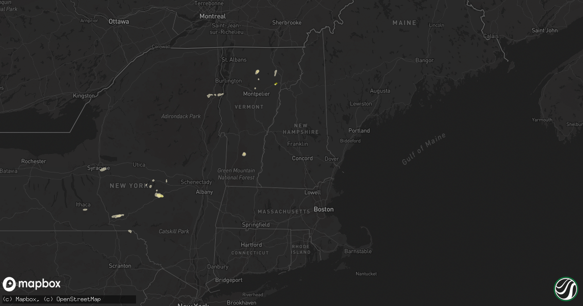
Hail Map in Vermont on July 7, 2023
Get this storm
July 7 map
$229
one time, instant access
Download today. No call, no setup
Keep the $229
Bought the map and want the full workflow? Apply the entire $229 to a subscription within 7 days. None of it is wasted.
Every map, not just this one
This buys you this map. Subscription and you get every map we run, in the markets you choose from a few cities to whole states to nationwide. Plus real-time alerts the moment a storm fires.
Contact data
Name, contact info, occupancy, even credit band for addresses in the footprint. You go from where it hit to who to call.
Become the source they trust
Unlimited branding weather history reports on demand. You already have the documented answer ready for the property owner, and you are the one who showed up with it.
Property data and RoofTrace estimates
Pull up any address you have got, its value and the exact code rules for that jurisdiction, straight from One Click Code. Then RoofTrace estimates the squares, pitch, and roof value, priced the way you price.
Storm reports in Vermont
Vermont
| Date | Description |
|---|---|
| 07/07/202312:48 PM CDT | 2nd downburst caused a down tree on power lines and produced additional power outages. |
| 07/07/202312:30 PM CDT | Multiple fire calls for trees and wires down near danville. |
| 07/07/202312:30 PM CDT | A local report indicates 1.00 inch wind near 2 E Danville |
| 07/07/202312:20 PM CDT | Trees down in sutton village. |
| 07/07/202311:42 AM CDT | Tree down |
| 07/07/202311:41 AM CDT | Down trees and wires on vermont route 14. |
| 07/07/202311:36 AM CDT | Several trees down near green river reservoir. |
| 07/07/202311:30 AM CDT | Wet microburst occurred near worcester with multiple reports of trees down by coop observer. |
| 07/07/202311:17 AM CDT | Trees on wires near the intersection of route 12 and keyser road. |
All States Impacted by Hail Map on July 7, 2023
Cities Impacted by Hail Map on July 7, 2023
- Liberal, KS
- Kismet, KS
- Plains, KS
- Meade, KS
- Forgan, OK
- Beaver, OK
- Gate, OK
- Laverne, OK
- Johnson, KS
- Richfield, KS
- Rolla, KS
- Hugoton, KS
- El Reno, OK
- Okarche, OK
- Calumet, OK
- Yukon, OK
- Piedmont, OK
- Bethany, OK
- Oklahoma City, OK
- Spencer, OK
- Edmond, OK
- Choctaw, OK
- Jones, OK
- Lawton, OK
- Taloga, OK
- Geary, OK
- Greenfield, OK
- Oakwood, OK
- Watonga, OK
- Seiling, OK
- Canton, OK
- Thomas, OK
- Fay, OK
- Kingfisher, OK
- Duncan, OK
- Ratliff City, OK
- Tussy, OK
- Danville, VT
- West Danville, VT
- Bennet, NE
- Osceola, NE
- Fort Sill, OK
- Morrisville, VT
- Hyde Park, VT
- Palmyra, NE
- Weleetka, OK
- New Ringgold, PA
- Fallston, MD
- Jarrettsville, MD
- Forest Hill, MD
- Elgin, OK
- Essex, NY
- Westport, NY
- Elizabethtown, NY
- Laurel, MD
- Walton, NE
- Lincoln, NE
- Sheffield, VT
- Lyndonville, VT
- Montpelier, VT
- Worcester, VT
- Wolcott, VT
- Dupree, SD
- Kulm, ND
- Ashley, ND
- Forbes, ND
- Moorhead, MN
- Sabin, MN
- Grenville, NM
- Folsom, NM
- Roswell, NM
- Dexter, NM
- Schenevus, NY
- Worcester, NY
- Hagerman, NM
- Clayton, NM
- Colorado Springs, CO
- Branson, CO
- Peyton, CO
- Trinidad, CO
- Cascade, CO
- Walsenburg, CO
- Texico, NM
- Clovis, NM
- Farwell, TX
- Bovina, TX
- Eureka, SD
- Calhan, CO
- Hartley, TX
- Channing, TX
- Dalhart, TX
- Adrian, TX
- Friona, TX
- Stratford, TX
- Dumas, TX
- Cactus, TX
- Sunray, TX
- Model, CO
- Vega, TX
- Masterson, TX
- Dimmitt, TX
- Hereford, TX
- Trinchera, CO
- Amarillo, TX
- Gruver, TX
- Morse, TX
- Stinnett, TX
- Nazareth, TX
- Fritch, TX
- Hart, TX
- Pep, TX
- Morton, TX
- Levelland, TX
- Amherst, TX
- Sudan, TX
- Whiteface, TX
- Enochs, TX
- Ropesville, TX
- Littlefield, TX
- Borger, TX
- Spearman, TX
- Panhandle, TX
- Wildorado, TX
- Tulia, TX
- Happy, TX
- Anton, TX
- Shallowater, TX
- Lubbock, TX
- Hale Center, TX
- Abernathy, TX
- Skellytown, TX
- Cripple Creek, CO
- Florissant, CO
- Miami, TX
- Perryton, TX
- Pampa, TX
- Smyer, TX
- Fuquay Varina, NC
- Victor, CO
- Groom, TX
- White Deer, TX
- Idalou, TX
- Petersburg, TX
- Lorenzo, TX
- Floydada, TX
- New Deal, TX
- Ralls, TX
- Claude, TX
- Mclean, TX
- Clarendon, TX
- Canadian, TX
- Mobeetie, TX
- Pueblo, CO
- Fountain, CO
- Wahpeton, ND
- Kent, MN
- Plainview, AR
- Perham, MN
- Angier, NC
- Vergas, MN
- Dent, MN
- Milnesand, NM
- Pep, NM
- Causey, NM
- Peru, VT
- Weston, VT
- Londonderry, VT
- Alachua, FL
- Livermore, CO
- New Effington, SD
- Hankinson, ND
- Rogers, NM
- Jamesville, NY
- Fayetteville, NY
- Syracuse, NY
- Manlius, NY
- Milner, GA
- Barnesville, GA
- Johnson, NE
- Crossroads, NM
- Tatum, NM
- Bryceville, FL
- Jacksonville, FL
- Kenansville, FL
- Saint Cloud, FL
- Tecumseh, NE
- Sterling, NE
- Warsaw, VA
- Fort Sumner, NM
- Portales, NM
- Enderlin, ND
- Jet, OK
- Cherokee, OK
- Edgeley, ND
- Manitou Springs, CO
- Des Moines, NM
- Richfield Springs, NY
- Springfield Center, NY
- Cooperstown, NY
- Mud Butte, SD
- Louisburg, NC
- Spring Hope, NC
- Broadview, NM
- Manchester, OK
- Medford, OK
- Brooktondale, NY
- Willseyville, NY
- Spencer, NY
- Ithaca, NY
- Auburn, NE
- Elk Creek, NE
- Crab Orchard, NE
- Verona, ND
- Litchville, ND
- Yellville, AR
- Selby, SD
- Nelson, NE
- Ruskin, NE
- Oak, NE
- Deshler, NE
- Burlington Flats, NY
- Hartwick, NY
- Crawfordville, FL
- Fort Lauderdale, FL
- Dania, FL
- Jennings, FL
- Long Lake, SD
- Eagle Butte, SD
- Mahaska, KS
- Harpursville, NY
- Chipley, FL
- Mosquero, NM
- Bluff City, KS
- Fly Creek, NY
- Port Crane, NY
- Mena, AR
- La Grange, NC
- Goldsboro, NC
- West Forks, ME
- Waubun, MN
- Clio, SC
- Leola, SD
- Mechanicsburg, PA
- Woodruff, UT
- Trail City, SD
- Burlington, OK
- Mahnomen, MN
- Unadilla, GA
- Caldwell, KS
- Tallahassee, FL
- Lisbon, ND
- Sheldon, ND
- Nome, ND
- Hatfield, AR
- Deridder, LA
- Pittston, PA
- Anthony, KS
- Waldron, KS
- Dillon, SC
- Patten, ME
- Hubbell, NE
- Chester, NE
- Bingham, ME
- Caratunk, ME
- Susquehanna, PA
- Deposit, NY
- Courtland, KS
- Webber, KS
- Scandia, KS
- Belleville, KS
- Madison, FL
- Honesdale, PA
- Ridgeway, SC
- Fleetwood, PA
- Kutztown, PA
- Afton, NY
- Chenango Forks, NY
- Enola, PA
- Java, SD
- San Mateo, FL
- Attica, KS
- Amistad, NM
- Canajoharie, NY
- Sharon Springs, NY
- Midland, SD
- Benson, NC
- Vredenburgh, AL
- Monroeville, AL
- McColl, SC
- Hawley, PA
- Lakeville, PA
- Willow Spring, NC
- Garner, NC
- Raleigh, NC
- Maryland, NY
- Shamrock, TX
- Wheeler, TX
- Briscoe, TX
- Boone, CO
- Hedley, TX
- Lelia Lake, TX
- Quail, TX
- Wellington, TX
- Texola, OK
- Reydon, OK
- Sweetwater, OK
- Durham, OK
- Erick, OK
- Arnett, OK
- Higgins, TX
- Crawford, OK
- Lipscomb, TX
- Shattuck, OK
- Follett, TX
- Booker, TX
- Fargo, OK
- Gage, OK
- Memphis, TX
- Sharon, OK
- Leedey, OK
- Hammon, OK
- Sayre, OK
- Cheyenne, OK
- Mangum, OK
- Dodson, TX
- Willow, OK
- Hollis, OK
- Elk City, OK
- Vinson, OK
- Gould, OK
- Childress, TX
- Quanah, TX
- Eldorado, OK
- Duke, OK
- Carter, OK
- Granite, OK
- Butler, OK
- Vici, OK
- Camargo, OK
- Dill City, OK
- Canute, OK
- Lone Wolf, OK
- Sentinel, OK
- Hobart, OK
- Foss, OK
- Ellington, MO
- Altus, OK
- Blair, OK
- Olustee, OK
- Elmer, OK
- Cordell, OK
- Arapaho, OK
- Custer City, OK
- Bessie, OK
- Corn, OK
- Clinton, OK
- Weatherford, OK
- Putnam, OK
- Winona, MO
- Van Buren, MO
- Altus Afb, OK
- Odell, TX
- Snyder, OK
- Tipton, OK
- Headrick, OK
- Vernon, TX
- Frederick, OK
- Davidson, OK
- Loveland, OK
- Grandfield, OK
- Electra, TX
- Hollister, OK
- Rocky, OK
- Gotebo, OK
- Mountain View, OK
- Fort Cobb, OK
- Carnegie, OK
- Apache, OK
- Fletcher, OK
- Anadarko, OK
- Cyril, OK
- Cement, OK
- Mutual, OK
- Harrold, TX
- Grandin, MO
- Plains, TX
- Sundown, TX
- Brownfield, TX
- Tokio, TX
- Meadow, TX
- Wilson, TX
- Slaton, TX
- Tahoka, TX
- Wolfforth, TX
- Ransom Canyon, TX
- Ola, AR
- Sawyer, KS
- Springfield, MO
- Turpin, OK
- Kingman, KS
- Onaka, SD
- Burchard, NE
- Waymart, PA
- Breckenridge, MN
- New York Mills, MN
- Rosholt, SD
- Salem, MO
- Yoder, CO
- Sisseton, SD
- Lidgerwood, ND
- Veblen, SD
- Ellsinore, MO
- Round O, SC
- Cottageville, SC
- Pollocksville, NC
- New Bern, NC
- Hooker, OK
- Bunker, MO
- Tie Siding, WY
- Vale, SD
- Sturgis, SD
- Millersburg, PA
- Elizabethville, PA
- Hardesty, OK
- Mount Ida, AR
- Eminence, MO
- Cayuga, ND
- Timmonsville, SC
- Muleshoe, TX
- Lake Arthur, NM
- Texline, TX
- Cook Sta, MO
- Hosmer, SD
- Bowdle, SD
- Roscoe, SD
- Ashland, KS
- Murdock, KS
- Beulah, CO
- Wheaton, MN
- Story, AR
- Morrowville, KS
- Dawson, NE
- Coats, NC
- Raymondville, MO
- Licking, MO
- Lenox, MO
- Dumont, MN
- Cumberland, VA
- Campbell, MN
- Tintah, MN
- Pritchett, CO
- Fowler, KS
- Nara Visa, NM
- Logan, NM
- Baldwin, MD
- Clarkton, NC
- Council, NC
- Elizabethtown, NC
- Hanceville, AL
- Elgin, SC
- Blythewood, SC
- Columbia, SC
- Tyrone, OK
- Penrose, CO
- Valley Center, KS
- Savannah, GA
- Nichols, SC
- Mound City, SD
- Hartshorn, MO
- Edgar Springs, MO
- Fergus Falls, MN
- Wichita, KS
- Ashburn, GA
- Beulah, MO
- Hardeeville, SC
- Saint James, MO
- Dillwyn, VA
- Birch Tree, MO
- Huntsville, AL
- Owens Cross Roads, AL
- New Hope, AL
- Haviland, KS
- Coats, KS
- Lesterville, MO
- Black, MO
- Englewood, KS
- King And Queen Court House, VA
- West Point, VA
- Baileyville, KS
- Beattie, KS
- Axtell, KS
- Tabor City, NC
- Green Sea, SC
- Cerro Gordo, NC
- Ozark, MO
- Rogersville, MO
- Rawlins, WY
- Lamar, CO
- Hasty, CO
- Carlisle, PA
- Isabel, KS
- Medicine Lodge, KS
- Dalmatia, PA
- Fremont, MO
- Doniphan, MO
- Alton, MO
- Hanna, WY
- Westville, OK
- Mullins, SC
- Sharon, KS
- Zenda, KS
- Lincoln, IL
- Pryor, OK
- Rocky Ford, CO
- Pocahontas, AR
- Maynard, AR
- Tahlequah, OK
- Hulbert, OK
- Bixby, OK
- Mounds, OK
- Gatewood, MO
- Unionville, VA
- Chouteau, OK
- Sun City, KS
- Orange, VA
- Couch, MO
- Carlyle, IL
- Quinton, OK
- Adair, OK
- Chelsea, OK
- Eufaula, OK
- Florence, KS
- Mullinville, KS


