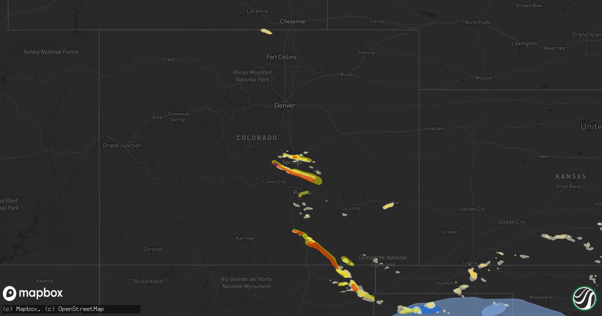
Hail Map on July 7, 2023
Get this storm
July 7 map
$229
one time, instant access
Download today. No call, no setup
Keep the $229
Bought the map and want the full workflow? Apply the entire $229 to a subscription within 7 days. None of it is wasted.
Every map, not just this one
This buys you this map. Subscription and you get every map we run, in the markets you choose from a few cities to whole states to nationwide. Plus real-time alerts the moment a storm fires.
Contact data
Name, contact info, occupancy, even credit band for addresses in the footprint. You go from where it hit to who to call.
Become the source they trust
Unlimited branding weather history reports on demand. You already have the documented answer ready for the property owner, and you are the one who showed up with it.
Property data and RoofTrace estimates
Pull up any address you have got, its value and the exact code rules for that jurisdiction, straight from One Click Code. Then RoofTrace estimates the squares, pitch, and roof value, priced the way you price.
States Impacted by Hail Map on July 7, 2023
Storm reports
Arkansas
| Date | Description |
|---|---|
| 07/06/20237:02 PM CDT | Part of the roof at the mountain harbor resort marina over the docks/boat slips damaged. Winds estimated by radar to be around 40 mph. |
Virginia
| Date | Description |
|---|---|
| 07/07/20236:48 PM CDT | Tree down blocking route 610. |
| 07/07/20236:34 PM CDT | Corrects previous tstm wnd dmg report from 2 wsw new canton. Numerous trees and power lines down across the eastern portion of the county beginning at arvonia and conti |
| 07/07/20236:30 PM CDT | Tree limbs downed on cloverdale road. Utility outage map also shows several power outages due to storm in the area. Time is estimated. |
| 07/07/20236:30 PM CDT | Trees downed along cartersville road at va-45. Time estimated. |
| 07/07/20235:45 PM CDT | Tree limbs downed onto power lines at west green springs road. Numerous power outages reported due to thunderstorms. |
| 07/07/20235:09 PM CDT | Large tree down on the road near the intersection of stony point road and echo valley road. |
| 07/07/20234:50 PM CDT | Corrects previous tstm wind dmg report from 3 ese rose garden for time. Tree downed on foxes tract road. |
| 07/07/20234:09 PM CDT | Large tree down near the 3900 block of hebron valley road |
| 07/07/20234:05 PM CDT | Tree downed on foxes tract road. |
| 07/07/20233:56 PM CDT | Multiple large trees down near the 2100 block of s f t valley road. |
| 07/07/20232:35 PM CDT | Multiple trees down on powerlines in the area around good hope road. |
| 07/07/20232:33 PM CDT | Multiple trees down onto powerlines near ridge road. |
| 07/07/20232:21 PM CDT | Multiple trees down onto powerlines around owens drive in dahlgren. |
| 07/06/20237:43 PM CDT | Trees down along s james madison highway. |
| 07/06/20237:29 PM CDT | Trees down along plank road. |
| 07/06/20237:22 PM CDT | Trees downed in numerous locations along anderson and cumberland roads in the western portion of cumberland county. Numerous power outages reported county wide. Time es |
| 07/06/20237:22 PM CDT | Trees downed in numerous locations along anderson and cumberland roads in the western portion of cumberland county. Time estimated. |
| 07/06/20237:16 PM CDT | Trees down along claybank road. |
| 07/06/20237:10 PM CDT | Trees and pasture fencing blown down. Time estimated from radar. |
| 07/06/20237:09 PM CDT | Trees down along e james anderson hwy. |
South Dakota
| Date | Description |
|---|---|
| 07/07/20234:11 PM CDT | Photo of nickel to quarter sized hail. |
Colorado
| Date | Description |
|---|---|
| 07/07/20236:45 PM CDT | Picture from social media... Size estimated. |
| 07/07/20236:40 PM CDT | Reports of damaged windows in cars and communications lines down. Size estimated. |
| 07/07/20236:35 PM CDT | Damage to windshields and skylights. Time estimated from radar. |
| 07/07/20235:18 PM CDT | Report from mping: half dollar |
| 07/07/20235:02 PM CDT | Report from mping: quarter |
| 07/07/20235:01 PM CDT | Report from mping: quarter |
| 07/07/20234:52 PM CDT | Report from mping: quarter |
| 07/07/20234:35 PM CDT | Report from mping: half dollar |
| 07/07/20234:26 PM CDT | A local report indicates 1.75 inch wind near 2 NW Peterson AFB |
| 07/07/20234:26 PM CDT | Report from mping: quarter |
| 07/07/20234:25 PM CDT | Report from mping: half dollar |
| 07/07/20234:24 PM CDT | Report from mping: quarter |
| 07/07/20234:23 PM CDT | Report from mping: quarter |
| 07/07/20234:23 PM CDT | A local report indicates 1.00 inch wind near 6 NNW Peterson AFB |
| 07/07/20234:21 PM CDT | A local report indicates 1.50 inch wind near 2 NW Peterson AFB |
| 07/07/20234:20 PM CDT | Report from mping: quarter |
| 07/06/20237:04 PM CDT | A local report indicates 1.00 inch wind near 5 W Blende |
South Carolina
| Date | Description |
|---|---|
| 07/07/20235:15 PM CDT | Tree limb fell onto residential power line resulted in a local power outage. |
| 07/07/20235:05 PM CDT | Trained storm spotters reports estimated 60 mph winds near the intersection of hard scrabble road and lake carolina blvd. Time estimated from radar. |
| 07/07/20234:54 PM CDT | Corrects previous tstm wnd dmg report from 5 e blythewood. Added location. Several large tree branches down with power outage also reported. Located on dobson rd. |
| 07/07/20234:54 PM CDT | Several large tree branches down with power outage also reported. |
| 07/07/20233:58 PM CDT | Corrects previous tstm wnd dmg report from 1 sse oak grove. Corrects previous tstm wnd dmg report from 1 sse oak grove. Public report via social media with pictures. Tr |
| 07/07/20233:58 PM CDT | Corrects previous tstm wnd dmg report from 1 sse oak grove. Public report via social media with pictures. Tree down on power lines at 200 ermine road. The tree went thr |
| 07/07/20233:58 PM CDT | Public report via social media with pictures. Tree down on power lines at 200 ermine road. The tree went through the windshield of a pickup truck. No injuries. Peak win |
| 07/07/20232:00 PM CDT | Tree down near the intersection of flint hill dr and n glassy mountain rd. |
Texas
| Date | Description |
|---|---|
| 07/07/20236:55 PM CDT | A local report indicates 64 MPH wind near 2 SSW Levelland |
| 07/07/20236:54 PM CDT | West texas mesonet report. |
| 07/07/20236:40 PM CDT | First severe wind gust of 59 mph was at 1840cdt. Peak wind gust of 61 mph was at 1852cdt. Last 60 mph wind gust was at 1857cdt. |
| 07/07/20236:40 PM CDT | West texas mesonet report. |
| 07/07/20236:40 PM CDT | A local report indicates 75 MPH wind near 3 SE Pantex |
| 07/07/20236:39 PM CDT | First gust of 61 mph at 1839cdt... Gust picked back up to 61 at 1848cdt. Peak gust of 65 mph was at 1849cdt and last 61 mph wind gust was at 1850cdt. |
| 07/07/20236:35 PM CDT | A local report indicates 60 MPH wind near 2 N Spearman |
| 07/07/20236:32 PM CDT | West texas mesonet report. Additional severe gust at 6:13p. |
| 07/07/20236:26 PM CDT | West texas mesonet report. Additional severe gust to 61 mph at 6:27p. |
| 07/07/20236:18 PM CDT | Multiple wind gusts in excess of 58 mph measured by the mesonet located 9 nne of amarillo. |
| 07/07/20236:15 PM CDT | Large tree branches down by intersection near sam houston park. |
| 07/07/20236:13 PM CDT | A local report indicates 75 MPH wind near 2 N Borger |
| 07/07/20236:11 PM CDT | Metal fence blown out into roadway. |
| 07/07/20236:11 PM CDT | A local report indicates 65 MPH wind near 7 E Borger |
| 07/07/20236:10 PM CDT | Report sent in by emergency manager with pictures of large trees limbs snapped... Large signs blown over... And metal shingles ripped off roof of house in the town of f |
| 07/07/20236:10 PM CDT | A local report indicates 74 MPH wind near 10 ESE Valley de Oro |
| 07/07/20236:04 PM CDT | Mesonet measured 66 mph wind gust at 1804cdt and peaked at 69 mph at 1806cdt. Still gusting upwards of 64 mph at 1810cdt. |
| 07/07/20235:57 PM CDT | West texas mesonet report. |
| 07/07/20235:49 PM CDT | A local report indicates 58 MPH wind near 1 NW Boys Ranch |
| 07/07/20235:47 PM CDT | West texas mesonet report. |
| 07/07/20235:38 PM CDT | Mesonet station near sunray measured multiple wind gusts between 58 and 61 mph between 1738cdt and 1747cdt. |
| 07/07/20235:36 PM CDT | West texas mesonet report. Multiple severe wind gusts from 5:35p to 5:40p. |
| 07/07/20235:34 PM CDT | West texas mesonet report. Multiple severe gusts from 5:25p to 5:38p. |
| 07/07/20235:25 PM CDT | Video of tornado looking west from a few miles southeast of stratford. Tornado was intermittently on the ground for about 2 minutes. |
| 07/07/20234:55 PM CDT | West texas mesonet report |
| 07/07/20234:35 PM CDT | Corrects previous tstm wnd gst report from 3 sw dalhart. From 1635cdt through 1650cdt the asos in dalhart gusted 58 to 64 mph from a line of thunderstorms moving throug |
| 07/07/20233:35 PM CDT | From 1535cdt through 1550cdt the asos in dalhart gusted 58 to 64 mph from a line of thunderstorms moving through. |
| 07/07/202312:05 AM CDT | A local report indicates 60 MPH wind near 6 SSW Lubbock |
| 07/06/202311:57 PM CDT | A local report indicates 64 MPH wind near 2 WNW Burris |
| 07/06/202311:57 PM CDT | A local report indicates 58 MPH wind near Reese Center |
| 07/06/202311:48 PM CDT | A local report indicates 59 MPH wind near 6 SSW Wolfforth |
| 07/06/202311:46 PM CDT | A local report indicates 60 MPH wind near Reese Center |
| 07/06/202310:51 PM CDT | A local report indicates 66 MPH wind near 8 WSW Sundown |
| 07/06/20239:55 PM CDT | Wilbarger county airport. |
| 07/06/20238:24 PM CDT | 59 mph wind gusts were reported at 824 and 827 pm cdt at the post west texas mesonet site. |
| 07/06/20238:16 PM CDT | First wind gust was 66 mph at 2016cdt. A gust of 73 mph was measured at 2018cdt. The mesonet measured an even higher wind gust of 76 mph at 2025cdt and continued to gus |
| 07/06/20238:10 PM CDT | Multiple reports of tree damage across wellington. Branches ranges from 1 inch to greater than 3 inches. Time estimated from radar. |
| 07/06/20238:06 PM CDT | A local report indicates 60 MPH wind near 1 ENE Mclean |
| 07/06/20237:27 PM CDT | Mesonet gusted to 76 mph at 1927cdt... And quickly measured a 95 and 96 mph gust over the next two minute. Last gust of 61 mph was at 1935cdt. |
| 07/06/20237:27 PM CDT | Mesonet gusted to 76 mph at 1927cdt... And quickly measured a 95 and 96 mph gust over the next two minute. Last gust of 61 mph was at |
| 07/06/20237:22 PM CDT | A local report indicates 66 MPH wind near 6 ESE Lora |
| 07/06/20237:11 PM CDT | A local report indicates 60 MPH wind near Goodnight |
| 07/06/20237:10 PM CDT | A local report indicates 60 MPH wind near 2 WNW Lake Mcclellan |
| 07/06/20237:09 PM CDT | A local report indicates 60 MPH wind near 5 S Wolfforth |
North Carolina
| Date | Description |
|---|---|
| 07/07/20236:36 PM CDT | Tree down near southern wayne high school. |
| 07/07/20236:25 PM CDT | Tree down blocking highway 87 east near intersection with airport road in council... Nc. Time estimated based on radar. Lightning strike damage possible. |
| 07/07/20236:20 PM CDT | A local report indicates 1.25 inch wind near 1 S Fuquay-Varina |
| 07/07/20236:18 PM CDT | A local report indicates 1.00 inch wind near 3 SSE Fuquay-Varina |
| 07/07/20236:09 PM CDT | Tree down on c r lewis dairy rd. |
| 07/07/20236:05 PM CDT | Fallen trees or limbs damaged power equipment. |
| 07/07/20235:57 PM CDT | 1 downed tree. |
| 07/07/20235:55 PM CDT | Tree down on 638 old grantham rd. |
| 07/07/20235:50 PM CDT | Fallen trees or limbs damaged power equipment. |
| 07/07/20235:48 PM CDT | Report from mping: quarter sized hail |
| 07/07/20235:39 PM CDT | Fallen trees or limbs damaged power equipment. |
| 07/07/20235:32 PM CDT | 1 downed tree. |
| 07/07/20234:45 PM CDT | Tree downed on gliden road. Time estimated. |
| 07/07/20234:45 PM CDT | Tree downed on gliden |
| 07/07/20234:39 PM CDT | Fallen trees or limbs damaged power equipment. |
| 07/07/20234:36 PM CDT | Large tree down near/on a house. Time estimated by radar. |
| 07/07/20234:28 PM CDT | Fallen trees or limbs damaged power equipment. |
| 07/07/20234:13 PM CDT | Multiple trees and powerlines down. A house was moved off of its foundation. |
| 07/06/20237:16 PM CDT | Duplin county 911 center reports trees down in the teachey area. |
| 07/06/20237:09 PM CDT | Power outage caused by fallen trees and limbs on equipment. |
Florida
| Date | Description |
|---|---|
| 07/07/20235:10 PM CDT | Tree down on power line. |
| 07/07/20234:45 PM CDT | Tree damage reported along sr 6. |
| 07/07/20234:42 PM CDT | Tree on power line on paul poppell road. |
| 07/07/20234:38 PM CDT | Duke energy reports power outages on the northeast side of perry due to tree damage. |
| 07/07/20234:38 PM CDT | Delayed report of power line and pole down on top of a tracker. Time estimated from radar. |
| 07/07/20234:32 PM CDT | Power line down along county road 251. |
| 07/07/20234:16 PM CDT | Tree down on power line along sundown creek road. |
| 07/07/20234:03 PM CDT | Tree down along upper cody road. |
| 07/07/20233:36 PM CDT | Duke energy reports power outages near newport due to tree damage. |
| 07/07/20233:23 PM CDT | Fhp reports power line down on roadway near bluebird lane and summerwood drive. |
| 07/07/20232:39 PM CDT | Delayed report. Three trees down across terrell road near the jacksonville international airport. Time estimated by radar downburst signature. |
New York
| Date | Description |
|---|---|
| 07/07/20233:23 PM CDT | Trees on wires. |
| 07/07/20233:12 PM CDT | Tree down on wires on pleasant ave near main st. |
| 07/07/20233:02 PM CDT | Trees and wires down. |
| 07/07/20232:46 PM CDT | Tree down on route 79. |
| 07/07/20232:39 PM CDT | Trees on wires. |
| 07/07/20232:16 PM CDT | Wires down on boswell hill road. |
| 07/07/20232:15 PM CDT | Tree down on river street. |
| 07/07/20231:52 PM CDT | Trees on powerlines. Trees on a few vehicles and a home. |
| 07/07/20231:41 PM CDT | Tree on wire. |
| 07/07/20231:33 PM CDT | Trees on wires |
| 07/07/20231:23 PM CDT | Tree down on road... Blocking lane of traffic. Via county dispatch feed. Radar estimated time. |
| 07/07/202312:55 PM CDT | Small tree fell down onto an unoccupied little league baseball field and damaged the outfield chainlink fence. |
| 07/07/202312:53 PM CDT | Trees and wires down according to county dispatch feed... Blocking cedar bay road. Radar-estimated time. |
| 07/07/202312:53 PM CDT | Trees and wires down according to cou |
| 07/07/202311:35 AM CDT | Trees and wires down on lake shore road. |
| 07/07/202311:30 AM CDT | Trees and wires down between westport and essex from wet microburst. |
| 07/07/202311:30 AM CDT | A few trees down. |
| 07/07/202311:28 AM CDT | Trees down... Windows blown out... And other property damage. |
| 07/07/202310:55 AM CDT | Trees and wires down in wadhams. |
Missouri
| Date | Description |
|---|---|
| 07/07/20231:20 AM CDT | Several trees down near intersection of hwy 160w and j hwy. Observed by local firefighter and relayed by doniphan pd. Time estimated from radar. |
| 07/06/202310:30 PM CDT | Large tree limb down along hwy 60. |
| 07/06/202310:20 PM CDT | Several large tree limbs down. |
| 07/06/20239:28 PM CDT | Damage to windshields and windows reported in ellington. |
| 07/06/20239:25 PM CDT | Reynolds county sheriff department has received numerous reports of trees and power lines down within the city of ellington. Time estimated from radar. |
| 07/06/20238:18 PM CDT | At least 50 mph winds. Tree down. |
| 07/06/20238:18 PM CDT | Reports of numerous trees and branches down in the galloway area. |
| 07/06/20237:05 PM CDT | A local report indicates 1.00 inch wind near Galloway |
North Dakota
| Date | Description |
|---|---|
| 07/07/20232:00 PM CDT | Ongoing tornado reported from law enforcement. |
| 07/07/20231:27 PM CDT | A local report indicates 1.00 inch wind near 5 SW Kulm |
New Mexico
| Date | Description |
|---|---|
| 07/07/20235:10 PM CDT | Mesonet station svan5 se vaughn. |
| 07/07/20234:45 PM CDT | Near white out conditions with hail falling. |
| 07/07/20234:28 PM CDT | Awos station kcvn clovis muni airport. |
| 07/07/20234:15 PM CDT | A local report indicates 1.00 inch wind near 1 W Clayton |
| 07/07/20234:12 PM CDT | A local report indicates 1.00 inch wind near Roswell Correctional Fa |
| 07/07/20233:27 PM CDT | Awos station k4mr 12 se tolar. |
Pennsylvania
| Date | Description |
|---|---|
| 07/07/20235:49 PM CDT | Wires down on rutter road. |
| 07/07/20235:31 PM CDT | Trees and wires down along route 6. Time estimated by radar. |
| 07/07/20235:03 PM CDT | Corrects the time from previous tstm wnd dmg report from 2 se westminister. Trees down blocking roadway. Time estimated by radar. |
| 07/07/20234:32 PM CDT | Corrects the time previous tstm wnd dmg report from west pittston. Trees down blocking roadway. Time estimated by radar. |
| 07/07/20234:03 PM CDT | Trees down blocking roadway. Time estimated by radar. |
| 07/07/20233:32 PM CDT | Trees down blocking roadway. Time estimated by radar. |
| 07/07/20231:21 PM CDT | Pictures sent in via social media of widespread corn crop damage in an open field due to a downburst. Time estimated from radar. |
Oklahoma
| Date | Description |
|---|---|
| 07/07/20238:55 AM CDT | Kduc. |
| 07/07/20238:06 AM CDT | Kokc. |
| 07/07/20238:05 AM CDT | Light pole blown down onto vehicle. |
| 07/07/20237:54 AM CDT | A local report indicates 72 MPH wind near Meers |
| 07/07/20237:23 AM CDT | A local report indicates 58 MPH wind near Okarche |
| 07/06/20239:27 PM CDT | Altus afb. |
| 07/06/20238:55 PM CDT | A local report indicates 59 MPH wind near 2 WSW Woodward |
| 07/06/20238:55 PM CDT | A local report indicates 59 MPH wind near 1 NE Woodward |
| 07/06/20238:53 PM CDT | Tree down near elk city pd. |
| 07/06/20238:50 PM CDT | A local report indicates 63 MPH wind near 4 WNW Camargo |
| 07/06/20238:50 PM CDT | Foss state park ranger reports damage to a cabin... Trees and vehicles... Mainly on the south side of foss reservoir. |
| 07/06/20238:50 PM CDT | A local report indicates 74 MPH wind near 2 NE Elk City |
| 07/06/20238:50 PM CDT | A local report indicates 63 MPH wind near 3 WNW Camargo |
| 07/06/20238:45 PM CDT | A local report indicates 68 MPH wind near 5 S Elk City |
| 07/06/20238:45 PM CDT | A local report indicates 68 MPH wind near 5 S Elk City |
| 07/06/20237:57 PM CDT | Brick building reportedly collapsed. Time estimated by radar. |
Georgia
| Date | Description |
|---|---|
| 07/07/20234:51 PM CDT | Received report from em of numerous trees down in a multiple block radius of mahaffey st in the town of jefferson. Roughly 10 trees down on houses or cars. |
| 07/07/20234:20 PM CDT | Nws peachtree city relayed two reports of thunderstorm wind damage. There was a report of trees and power lines down along brooklet-denmark rd at brannen pond connector |
Vermont
| Date | Description |
|---|---|
| 07/07/202312:48 PM CDT | 2nd downburst caused a down tree on power lines and produced additional power outages. |
| 07/07/202312:30 PM CDT | A local report indicates 1.00 inch wind near 2 E Danville |
| 07/07/202312:30 PM CDT | Multiple fire calls for trees and wires down near danville. |
| 07/07/202312:20 PM CDT | Trees down in sutton village. |
| 07/07/202311:42 AM CDT | Tree down |
| 07/07/202311:41 AM CDT | Down trees and wires on vermont route 14. |
| 07/07/202311:36 AM CDT | Several trees down near green river reservoir. |
| 07/07/202311:30 AM CDT | Wet microburst occurred near worcester with multiple reports of trees down by coop observer. |
| 07/07/202311:17 AM CDT | Trees on wires near the intersection of route 12 and keyser road. |
Maryland
| Date | Description |
|---|---|
| 07/07/202312:03 PM CDT | One large tree down and multiple large limbs down near the 1900 block of parkwood drive. |
| 07/07/202310:59 AM CDT | Large tree down near the 10600 block of delfield court. |
Maine
| Date | Description |
|---|---|
| 07/07/20231:36 PM CDT | Tree down on power line in garfield plantation. Time estimated based on radar. |
Cities Impacted by Hail Map on July 7, 2023
- Liberal, KS
- Kismet, KS
- Plains, KS
- Meade, KS
- Forgan, OK
- Beaver, OK
- Gate, OK
- Laverne, OK
- Johnson, KS
- Richfield, KS
- Rolla, KS
- Hugoton, KS
- El Reno, OK
- Okarche, OK
- Calumet, OK
- Yukon, OK
- Piedmont, OK
- Bethany, OK
- Oklahoma City, OK
- Spencer, OK
- Edmond, OK
- Choctaw, OK
- Jones, OK
- Lawton, OK
- Taloga, OK
- Geary, OK
- Greenfield, OK
- Oakwood, OK
- Watonga, OK
- Seiling, OK
- Canton, OK
- Thomas, OK
- Fay, OK
- Kingfisher, OK
- Duncan, OK
- Ratliff City, OK
- Tussy, OK
- Danville, VT
- West Danville, VT
- Bennet, NE
- Osceola, NE
- Fort Sill, OK
- Morrisville, VT
- Hyde Park, VT
- Palmyra, NE
- Weleetka, OK
- New Ringgold, PA
- Fallston, MD
- Jarrettsville, MD
- Forest Hill, MD
- Elgin, OK
- Essex, NY
- Westport, NY
- Elizabethtown, NY
- Laurel, MD
- Walton, NE
- Lincoln, NE
- Sheffield, VT
- Lyndonville, VT
- Montpelier, VT
- Worcester, VT
- Wolcott, VT
- Dupree, SD
- Kulm, ND
- Ashley, ND
- Forbes, ND
- Moorhead, MN
- Sabin, MN
- Grenville, NM
- Folsom, NM
- Roswell, NM
- Dexter, NM
- Schenevus, NY
- Worcester, NY
- Hagerman, NM
- Clayton, NM
- Colorado Springs, CO
- Branson, CO
- Peyton, CO
- Trinidad, CO
- Cascade, CO
- Walsenburg, CO
- Texico, NM
- Clovis, NM
- Farwell, TX
- Bovina, TX
- Eureka, SD
- Calhan, CO
- Hartley, TX
- Channing, TX
- Dalhart, TX
- Adrian, TX
- Friona, TX
- Stratford, TX
- Dumas, TX
- Cactus, TX
- Sunray, TX
- Model, CO
- Vega, TX
- Masterson, TX
- Dimmitt, TX
- Hereford, TX
- Trinchera, CO
- Amarillo, TX
- Gruver, TX
- Morse, TX
- Stinnett, TX
- Nazareth, TX
- Fritch, TX
- Hart, TX
- Pep, TX
- Morton, TX
- Levelland, TX
- Amherst, TX
- Sudan, TX
- Whiteface, TX
- Enochs, TX
- Ropesville, TX
- Littlefield, TX
- Borger, TX
- Spearman, TX
- Panhandle, TX
- Wildorado, TX
- Tulia, TX
- Happy, TX
- Anton, TX
- Shallowater, TX
- Lubbock, TX
- Hale Center, TX
- Abernathy, TX
- Skellytown, TX
- Cripple Creek, CO
- Florissant, CO
- Miami, TX
- Perryton, TX
- Pampa, TX
- Smyer, TX
- Fuquay Varina, NC
- Victor, CO
- Groom, TX
- White Deer, TX
- Idalou, TX
- Petersburg, TX
- Lorenzo, TX
- Floydada, TX
- New Deal, TX
- Ralls, TX
- Claude, TX
- Mclean, TX
- Clarendon, TX
- Canadian, TX
- Mobeetie, TX
- Pueblo, CO
- Fountain, CO
- Wahpeton, ND
- Kent, MN
- Plainview, AR
- Perham, MN
- Angier, NC
- Vergas, MN
- Dent, MN
- Milnesand, NM
- Pep, NM
- Causey, NM
- Peru, VT
- Weston, VT
- Londonderry, VT
- Alachua, FL
- Livermore, CO
- New Effington, SD
- Hankinson, ND
- Rogers, NM
- Jamesville, NY
- Fayetteville, NY
- Syracuse, NY
- Manlius, NY
- Milner, GA
- Barnesville, GA
- Johnson, NE
- Crossroads, NM
- Tatum, NM
- Bryceville, FL
- Jacksonville, FL
- Kenansville, FL
- Saint Cloud, FL
- Tecumseh, NE
- Sterling, NE
- Warsaw, VA
- Fort Sumner, NM
- Portales, NM
- Enderlin, ND
- Jet, OK
- Cherokee, OK
- Edgeley, ND
- Manitou Springs, CO
- Des Moines, NM
- Richfield Springs, NY
- Springfield Center, NY
- Cooperstown, NY
- Mud Butte, SD
- Louisburg, NC
- Spring Hope, NC
- Broadview, NM
- Manchester, OK
- Medford, OK
- Brooktondale, NY
- Willseyville, NY
- Spencer, NY
- Ithaca, NY
- Auburn, NE
- Elk Creek, NE
- Crab Orchard, NE
- Verona, ND
- Litchville, ND
- Yellville, AR
- Selby, SD
- Nelson, NE
- Ruskin, NE
- Oak, NE
- Deshler, NE
- Burlington Flats, NY
- Hartwick, NY
- Crawfordville, FL
- Fort Lauderdale, FL
- Dania, FL
- Jennings, FL
- Long Lake, SD
- Eagle Butte, SD
- Mahaska, KS
- Harpursville, NY
- Chipley, FL
- Mosquero, NM
- Bluff City, KS
- Fly Creek, NY
- Port Crane, NY
- Mena, AR
- La Grange, NC
- Goldsboro, NC
- West Forks, ME
- Waubun, MN
- Clio, SC
- Leola, SD
- Mechanicsburg, PA
- Woodruff, UT
- Trail City, SD
- Burlington, OK
- Mahnomen, MN
- Unadilla, GA
- Caldwell, KS
- Tallahassee, FL
- Lisbon, ND
- Sheldon, ND
- Nome, ND
- Hatfield, AR
- Deridder, LA
- Pittston, PA
- Anthony, KS
- Waldron, KS
- Dillon, SC
- Patten, ME
- Hubbell, NE
- Chester, NE
- Bingham, ME
- Caratunk, ME
- Susquehanna, PA
- Deposit, NY
- Courtland, KS
- Webber, KS
- Scandia, KS
- Belleville, KS
- Madison, FL
- Honesdale, PA
- Ridgeway, SC
- Fleetwood, PA
- Kutztown, PA
- Afton, NY
- Chenango Forks, NY
- Enola, PA
- Java, SD
- San Mateo, FL
- Attica, KS
- Amistad, NM
- Canajoharie, NY
- Sharon Springs, NY
- Midland, SD
- Benson, NC
- Vredenburgh, AL
- Monroeville, AL
- McColl, SC
- Hawley, PA
- Lakeville, PA
- Willow Spring, NC
- Garner, NC
- Raleigh, NC
- Maryland, NY
- Shamrock, TX
- Wheeler, TX
- Briscoe, TX
- Boone, CO
- Hedley, TX
- Lelia Lake, TX
- Quail, TX
- Wellington, TX
- Texola, OK
- Reydon, OK
- Sweetwater, OK
- Durham, OK
- Erick, OK
- Arnett, OK
- Higgins, TX
- Crawford, OK
- Lipscomb, TX
- Shattuck, OK
- Follett, TX
- Booker, TX
- Fargo, OK
- Gage, OK
- Memphis, TX
- Sharon, OK
- Leedey, OK
- Hammon, OK
- Sayre, OK
- Cheyenne, OK
- Mangum, OK
- Dodson, TX
- Willow, OK
- Hollis, OK
- Elk City, OK
- Vinson, OK
- Gould, OK
- Childress, TX
- Quanah, TX
- Eldorado, OK
- Duke, OK
- Carter, OK
- Granite, OK
- Butler, OK
- Vici, OK
- Camargo, OK
- Dill City, OK
- Canute, OK
- Lone Wolf, OK
- Sentinel, OK
- Hobart, OK
- Foss, OK
- Ellington, MO
- Altus, OK
- Blair, OK
- Olustee, OK
- Elmer, OK
- Cordell, OK
- Arapaho, OK
- Custer City, OK
- Bessie, OK
- Corn, OK
- Clinton, OK
- Weatherford, OK
- Putnam, OK
- Winona, MO
- Van Buren, MO
- Altus Afb, OK
- Odell, TX
- Snyder, OK
- Tipton, OK
- Headrick, OK
- Vernon, TX
- Frederick, OK
- Davidson, OK
- Loveland, OK
- Grandfield, OK
- Electra, TX
- Hollister, OK
- Rocky, OK
- Gotebo, OK
- Mountain View, OK
- Fort Cobb, OK
- Carnegie, OK
- Apache, OK
- Fletcher, OK
- Anadarko, OK
- Cyril, OK
- Cement, OK
- Mutual, OK
- Harrold, TX
- Grandin, MO
- Plains, TX
- Sundown, TX
- Brownfield, TX
- Tokio, TX
- Meadow, TX
- Wilson, TX
- Slaton, TX
- Tahoka, TX
- Wolfforth, TX
- Ransom Canyon, TX
- Ola, AR
- Sawyer, KS
- Springfield, MO
- Turpin, OK
- Kingman, KS
- Onaka, SD
- Burchard, NE
- Waymart, PA
- Breckenridge, MN
- New York Mills, MN
- Rosholt, SD
- Salem, MO
- Yoder, CO
- Sisseton, SD
- Lidgerwood, ND
- Veblen, SD
- Ellsinore, MO
- Round O, SC
- Cottageville, SC
- Pollocksville, NC
- New Bern, NC
- Hooker, OK
- Bunker, MO
- Tie Siding, WY
- Vale, SD
- Sturgis, SD
- Millersburg, PA
- Elizabethville, PA
- Hardesty, OK
- Mount Ida, AR
- Eminence, MO
- Cayuga, ND
- Timmonsville, SC
- Muleshoe, TX
- Lake Arthur, NM
- Texline, TX
- Cook Sta, MO
- Hosmer, SD
- Bowdle, SD
- Roscoe, SD
- Ashland, KS
- Murdock, KS
- Beulah, CO
- Wheaton, MN
- Story, AR
- Morrowville, KS
- Dawson, NE
- Coats, NC
- Raymondville, MO
- Licking, MO
- Lenox, MO
- Dumont, MN
- Cumberland, VA
- Campbell, MN
- Tintah, MN
- Pritchett, CO
- Fowler, KS
- Nara Visa, NM
- Logan, NM
- Baldwin, MD
- Clarkton, NC
- Council, NC
- Elizabethtown, NC
- Hanceville, AL
- Elgin, SC
- Blythewood, SC
- Columbia, SC
- Tyrone, OK
- Penrose, CO
- Valley Center, KS
- Savannah, GA
- Nichols, SC
- Mound City, SD
- Hartshorn, MO
- Edgar Springs, MO
- Fergus Falls, MN
- Wichita, KS
- Ashburn, GA
- Beulah, MO
- Hardeeville, SC
- Saint James, MO
- Dillwyn, VA
- Birch Tree, MO
- Huntsville, AL
- Owens Cross Roads, AL
- New Hope, AL
- Haviland, KS
- Coats, KS
- Lesterville, MO
- Black, MO
- Englewood, KS
- King And Queen Court House, VA
- West Point, VA
- Baileyville, KS
- Beattie, KS
- Axtell, KS
- Tabor City, NC
- Green Sea, SC
- Cerro Gordo, NC
- Ozark, MO
- Rogersville, MO
- Rawlins, WY
- Lamar, CO
- Hasty, CO
- Carlisle, PA
- Isabel, KS
- Medicine Lodge, KS
- Dalmatia, PA
- Fremont, MO
- Doniphan, MO
- Alton, MO
- Hanna, WY
- Westville, OK
- Mullins, SC
- Sharon, KS
- Zenda, KS
- Lincoln, IL
- Pryor, OK
- Rocky Ford, CO
- Pocahontas, AR
- Maynard, AR
- Tahlequah, OK
- Hulbert, OK
- Bixby, OK
- Mounds, OK
- Gatewood, MO
- Unionville, VA
- Chouteau, OK
- Sun City, KS
- Orange, VA
- Couch, MO
- Carlyle, IL
- Quinton, OK
- Adair, OK
- Chelsea, OK
- Eufaula, OK
- Florence, KS
- Mullinville, KS