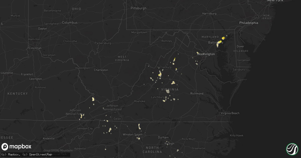
Hail Map in Virginia on July 5, 2020
Get this storm
July 5 map
$229
one time, instant access
Download today. No call, no setup
Keep the $229
Bought the map and want the full workflow? Apply the entire $229 to a subscription within 7 days. None of it is wasted.
Every map, not just this one
This buys you this map. Subscription and you get every map we run, in the markets you choose from a few cities to whole states to nationwide. Plus real-time alerts the moment a storm fires.
Contact data
Name, contact info, occupancy, even credit band for addresses in the footprint. You go from where it hit to who to call.
Become the source they trust
Unlimited branding weather history reports on demand. You already have the documented answer ready for the property owner, and you are the one who showed up with it.
Property data and RoofTrace estimates
Pull up any address you have got, its value and the exact code rules for that jurisdiction, straight from One Click Code. Then RoofTrace estimates the squares, pitch, and roof value, priced the way you price.
Storm reports in Virginia
Virginia
| Date | Description |
|---|---|
| 07/05/20206:48 PM CDT | Several trees were reported down across the county. |
| 07/05/20205:58 PM CDT | Quarter sized hail reported on route 39 in rockbridge baths. |
| 07/05/20205:42 PM CDT | A local report indicates 1.00 inch wind near 3 W EVERGREEN |
| 07/05/20205:22 PM CDT | A few trees down and high winds. |
| 07/05/20205:01 PM CDT | A few trees down. |
| 07/05/20204:41 PM CDT | Two trees were down in the deerfield area. |
| 07/05/20204:24 PM CDT | Multiple trees down along slate creek road to edgewater drive... Picture provided of large healthy tree downed at local university in grundy |
| 07/05/20204:20 PM CDT | Most hail less than half inch but a few up to quarter size |
| 07/05/20204:19 PM CDT | Several trees down. |
| 07/05/20204:10 PM CDT | Downed tree on power lines near lee hwy and cedar ln |
| 07/05/20204:04 PM CDT | Several trees down and hail. Hail size was not known. |
| 07/05/20204:03 PM CDT | A local report indicates 1.00 inch wind near 3 S HERNDON |
| 07/05/20203:59 PM CDT | Four trees down on slate road in stacy. Numerous power outages ongoing in area. |
| 07/05/20203:43 PM CDT | Tree reported down on rt. 20 near keene... Va. |
| 07/05/20202:47 PM CDT | A local report indicates 1.25 inch wind near RILEYVILLE |
| 07/05/20202:30 PM CDT | Trees reported down on boxley lane near maddox drive |
| 07/05/20202:30 PM CDT | Tree fell onto power line at the intersection of dry run rd and clearview rd. |
| 07/05/20202:24 PM CDT | Two trees down at the intersection of us 340 northbound and pass run rd. Lat/lon corrected. |
| 07/05/20202:24 PM CDT | Two trees down at the intersection of us 340 northbound and pass run rd. |
| 07/05/20202:19 PM CDT | A few trees reported down in luray |
| 07/05/20202:10 PM CDT | Multiple trees down blocking roads in the ivy area |
| 07/05/20202:10 PM CDT | Large tree downed at residence |
| 07/05/20201:20 PM CDT | Large tree down on wolftown-hood rd at the greene and madison county border. |
| 07/05/20203:35 AM CDT | At 834 PM EDT, a severe thunderstorm was located over Evergreen, or near Appomattox, moving north at 15 mph. HAZARD...60 mph wind gusts and quarter size hail. SOURCE...Radar indicated. IMPACT...Hail damage to vehicles is expected. Expect wind damage to roofs, siding, and trees. Locations impacted include... Appomattox... Concord... Pamplin City... Appomattox National Historic Park... Stonewall... Hixburg... and Oakville. |
| 07/05/20202:14 AM CDT | At 714 PM EDT, a severe thunderstorm was located over Mayodan, moving north at 15 mph. HAZARD...60 mph wind gusts and quarter size hail. SOURCE...Radar indicated. IMPACT...Hail damage to vehicles is expected. Expect wind damage to roofs, siding, and trees. Locations impacted include... Mayodan... Madison... Stoneville... Spencer... Sandy Ridge... Intelligence... and Ayersville. |
| 07/05/20201:27 AM CDT | At 626 PM EDT, a severe thunderstorm was located over Bells Valley, or near Goshen, moving south at 10 mph. HAZARD...60 mph wind gusts and quarter size hail. SOURCE...Radar indicated. IMPACT...Hail damage to vehicles is expected. Expect wind damage to roofs, siding, and trees. Locations impacted include... Goshen... Rockbridge Baths... Bells Valley... Fairfield... Brownsburg... Yost... and Vesuvius. |
| 07/05/20201:22 AM CDT | At 621 PM EDT, a severe thunderstorm was located over Bells Valley, or 7 miles northeast of Goshen, moving southeast at 5 mph. HAZARD...60 mph wind gusts and quarter size hail. SOURCE...Radar indicated. IMPACT...Damaging winds will cause some trees and large branches to fall. This could injure those outdoors, as well as damage homes and vehicles. Roadways may become blocked by downed trees. Localized power outages are possible. Unsecured light objects may become projectiles. Locations impacted include... Craigsville and Augusta Springs. |
| 07/05/20201:13 AM CDT | At 613 PM EDT, a severe thunderstorm was located over Cleveland Va, or near Lebanon, moving north at 10 mph. HAZARD...60 mph wind gusts and quarter size hail. SOURCE...Radar indicated. IMPACT...Hail damage to vehicles is expected. Expect wind damage to roofs, siding, and trees. Locations impacted include... Lebanon, Cleveland Va, Honaker and Castlewood. |
| 07/05/202012:44 AM CDT | At 544 PM EDT, a severe thunderstorm was located 11 miles southeast of Norton, moving northeast at 10 mph. HAZARD...60 mph wind gusts and quarter size hail. SOURCE...Radar indicated. IMPACT...Hail damage to vehicles is expected. Expect wind damage to roofs, siding, and trees. Locations impacted include... Coeburn, St. Paul, Nickelsville, Dungannon and Castlewood. |
| 07/05/202012:42 AM CDT | At 542 PM EDT, a severe thunderstorm was located near Staunton, moving southeast at 10 mph. HAZARD...60 mph wind gusts and quarter size hail. SOURCE...Radar indicated. IMPACT...Damaging winds will cause some trees and large branches to fall. This could injure those outdoors, as well as damage homes and vehicles. Roadways may become blocked by downed trees. Localized power outages are possible. Unsecured light objects may become projectiles. Locations impacted include... Staunton, Waynesboro, Stuarts Draft, Sherando, Wintergreen, Afton, Fishersville, Verona, Lyndhurst, Nellysford, Greenville, Middlebrook, Greenwood, Hermitage, Mint Spring, Greenfield and Afton Mountain. |
| 07/05/202012:38 AM CDT | At 538 PM EDT, a severe thunderstorm was located over Dulles International Airport, and is nearly stationary. HAZARD...60 mph wind gusts and quarter size hail. SOURCE...Radar indicated. IMPACT...Damaging winds will cause some trees and large branches to fall. This could injure those outdoors, as well as damage homes and vehicles. Roadways may become blocked by downed trees. Localized power outages are possible. Unsecured light objects may become projectiles. Locations impacted include... Centreville, Reston, South Riding, Herndon, Brambleton, Dulles International Airport, Ashburn, Oakton, Sterling, Chantilly, Wolf Trap, Great Falls, Countryside, Arcola and Sterling Park. |
| 07/05/202012:23 AM CDT | At 523 PM EDT, a severe thunderstorm was located 16 miles southeast of Monterey, moving southeast at 5 mph. HAZARD...60 mph wind gusts and quarter size hail. SOURCE...Radar indicated. IMPACT...Damaging winds will cause some trees and large branches to fall. This could injure those outdoors, as well as damage homes and vehicles. Roadways may become blocked by downed trees. Localized power outages are possible. Unsecured light objects may become projectiles. Locations impacted include... Augusta Springs, Churchville, Deerfield, West Augusta, Buffalo Gap, Trimbles Mill, Christian and Swoope. |
| 07/05/202012:12 AM CDT | At 511 PM EDT, a severe thunderstorm was located over Linton Hall, or 9 miles southwest of Centreville, moving north at 5 mph. HAZARD...60 mph wind gusts and quarter size hail. SOURCE...Radar indicated. IMPACT...Damaging winds will cause some trees and large branches to fall. This could injure those outdoors, as well as damage homes and vehicles. Roadways may become blocked by downed trees. Localized power outages are possible. Unsecured light objects may become projectiles. Locations impacted include... Centreville, South Riding, Linton Hall, Chantilly, Bull Run, Haymarket, Manassas, Sudley, Manassas Park, Gainesville, Nokesville, Catharpin, Woolsey and Greenwich. |
| 07/05/202012:07 AM CDT | At 507 PM EDT, a severe thunderstorm was located near Gate City, and is nearly stationary. HAZARD...60 mph wind gusts and nickel size hail. SOURCE...Radar indicated. IMPACT...Expect damage to roofs, siding, and trees. Locations impacted include... Gate City, St. Paul, Nickelsville, Dungannon, Collingwood, Castlewood, Fort Blackmore and Hiltons. |
| 07/04/202011:57 PM CDT | At 457 PM EDT, a severe thunderstorm was located 11 miles west of Franklin, moving southeast at 20 mph. HAZARD...60 mph wind gusts and quarter size hail. SOURCE...Radar indicated. IMPACT...Damaging winds will cause some trees and large branches to fall. This could injure those outdoors, as well as damage homes and vehicles. Roadways may become blocked by downed trees. Localized power outages are possible. Unsecured light objects may become projectiles. Locations impacted include... Circleville, Palo Alto, Blue Grass, Doe Hill, Possum Trot, Moyers, Sirons Mill, Cherry Grove, Sugar Grove, New Hampden, Harper and Mcdowell. |
| 07/04/202011:55 PM CDT | At 455 PM EDT, a severe thunderstorm was located near Staunton, moving southeast at 15 mph. HAZARD...60 mph wind gusts and quarter size hail. SOURCE...Radar indicated. IMPACT...Damaging winds will cause some trees and large branches to fall. This could injure those outdoors, as well as damage homes and vehicles. Roadways may become blocked by downed trees. Localized power outages are possible. Unsecured light objects may become projectiles. Locations impacted include... Staunton, Waynesboro, Stuarts Draft, Crimora, Sherando, Fishersville, Verona, Lyndhurst, New Hope, Mount Sidney, Churchville, Hermitage, Mint Spring and Fort Defiance. |
| 07/04/202011:46 PM CDT | At 446 PM EDT, a severe thunderstorm was located over Gate City, and is nearly stationary. HAZARD...60 mph wind gusts and penny size hail. SOURCE...Radar indicated. IMPACT...Expect damage to roofs, siding, and trees. Locations impacted include... Kingsport, Gate City, Weber City, Church Hill, Mount Carmel, Clinchport and Bloomingdale.This includes Interstate 26 in Tennessee near mile marker 1. |
| 07/04/202011:32 PM CDT | At 432 PM EDT, a severe thunderstorm was located 10 miles west of Lake Monticello, or 11 miles south of Charlottesville, moving southeast at 15 mph. HAZARD...60 mph wind gusts and quarter size hail. SOURCE...Radar indicated. IMPACT...Damaging winds will cause some trees and large branches to fall. This could injure those outdoors, as well as damage homes and vehicles. Roadways may become blocked by downed trees. Localized power outages are possible. Unsecured light objects may become projectiles. Locations impacted include... Scottsville, Esmont, Woodridge, Keene and Glendower. |
| 07/04/202011:30 PM CDT | At 429 PM EDT, a severe thunderstorm was located 8 miles east of Monterey, moving southeast at 10 mph. HAZARD...60 mph wind gusts and quarter size hail. SOURCE...Radar indicated. IMPACT...Damaging winds will cause some trees and large branches to fall. This could injure those outdoors, as well as damage homes and vehicles. Roadways may become blocked by downed trees. Localized power outages are possible. Unsecured light objects may become projectiles. Locations impacted include... West Augusta, Palo Alto, Doe Hill, Head Waters and Sirons Mill. |
| 07/04/202011:23 PM CDT | At 423 PM EDT, a severe thunderstorm was located near Bridgewater, or 7 miles southwest of Harrisonburg, and is nearly stationary. HAZARD...60 mph wind gusts and quarter size hail. SOURCE...Radar indicated. IMPACT...Damaging winds will cause some trees and large branches to fall. This could injure those outdoors, as well as damage homes and vehicles. Roadways may become blocked by downed trees. Localized power outages are possible. Unsecured light objects may become projectiles. Locations impacted include... Harrisonburg, Bridgewater, Grottoes, Massanutten, Crimora, Verona, Weyers Cave, Dayton, New Hope, Mount Sidney, Mount Crawford, Rocky Bar, Penn Laird, Port Republic, Hermitage, Pleasant Valley, Moscow, Montezuma, Mount Solon and Fort Defiance. |
| 07/04/202011:18 PM CDT | At 418 PM EDT, a severe thunderstorm was located near Front Royal, and is nearly stationary. HAZARD...60 mph wind gusts and quarter size hail. SOURCE...Radar indicated. IMPACT...Damaging winds will cause some trees and large branches to fall. This could injure those outdoors, as well as damage homes and vehicles. Roadways may become blocked by downed trees. Localized power outages are possible. Unsecured light objects may become projectiles. Locations impacted include... Front Royal, Karo, Glen Echo and Riverside. |
| 07/04/202011:12 PM CDT | At 412 PM EDT, a severe thunderstorm was located near Triangle, or near Quantico, and is nearly stationary. HAZARD...60 mph wind gusts and quarter size hail. SOURCE...Radar indicated. IMPACT...Damaging winds will cause some trees and large branches to fall. This could injure those outdoors, as well as damage homes and vehicles. Roadways may become blocked by downed trees. Localized power outages are possible. Unsecured light objects may become projectiles. Locations impacted include... Garrisonville, Widewater, Aquia, Ruby and Arkendale. |
| 07/04/202011:10 PM CDT | At 410 PM EDT, a severe thunderstorm was located over Colonial Heights, or near Kingsport, moving west at 5 mph. HAZARD...60 mph wind gusts and nickel size hail. SOURCE...Radar indicated. IMPACT...Expect damage to roofs, siding, and trees. Locations impacted include... Johnson City, Kingsport, Gray, Oak Grove, Spurgeon, Colonial Heights, Tri-City Airport, Sullivan Gardens, Fall Branch and Warriors Path State Park.This includes the following highways... Interstate 26 in Tennessee between mile markers 1 and 12. Interstate 81 in Tennessee between mile markers 52 and 68. |
| 07/04/202011:04 PM CDT | At 404 PM EDT, a severe thunderstorm was located near Charlottesville, moving southeast at 15 mph. HAZARD...60 mph wind gusts and quarter size hail. SOURCE...Radar indicated. IMPACT...Damaging winds will cause some trees and large branches to fall. This could injure those outdoors, as well as damage homes and vehicles. Roadways may become blocked by downed trees. Localized power outages are possible. Unsecured light objects may become projectiles. Locations impacted include... Boyd Tavern, Woodridge, Monticello and Overton. |
| 07/04/202011:02 PM CDT | At 402 PM EDT, a severe thunderstorm was located near Wingina, or 9 miles northeast of Bent Creek, moving southeast at 15 mph. HAZARD...60 mph wind gusts and quarter size hail. SOURCE...Radar indicated. IMPACT...Damaging winds will cause some trees and large branches to fall. This could injure those outdoors, as well as damage homes and vehicles. Roadways may become blocked by downed trees. Localized power outages are possible. Unsecured light objects may become projectiles. Locations impacted include... Shipman, Arrington, Norwood and Wingina. |
| 07/04/202010:40 PM CDT | At 340 PM EDT, a severe thunderstorm was located near Luray, or 12 miles southeast of Woodstock, moving northeast at 10 mph. HAZARD...60 mph wind gusts and quarter size hail. SOURCE...Radar indicated. IMPACT...Damaging winds will cause some trees and large branches to fall. This could injure those outdoors, as well as damage homes and vehicles. Roadways may become blocked by downed trees. Localized power outages are possible. Unsecured light objects may become projectiles. Locations impacted include... Luray, Sperryville, Washington, Kimball, Compton, Fourway, Fairview, Karo, Glen Echo, Bentonville, Panorama, Browntown and Rileyville. |
| 07/04/202010:25 PM CDT | At 324 PM EDT, a severe thunderstorm was located near Orange, moving east at 10 mph. HAZARD...60 mph wind gusts and quarter size hail. SOURCE...Radar indicated. IMPACT...Damaging winds will cause some trees and large branches to fall. This could injure those outdoors, as well as damage homes and vehicles. Roadways may become blocked by downed trees. Localized power outages are possible. Unsecured light objects may become projectiles. Locations impacted include... Orange, Thornhill, Madison Run and Lahore. |
| 07/04/202010:16 PM CDT | At 316 PM EDT, a severe thunderstorm was located over Luray, or 12 miles south of Woodstock, moving northeast at 15 mph. HAZARD...60 mph wind gusts and quarter size hail. SOURCE...Radar indicated. IMPACT...Damaging winds will cause some trees and large branches to fall. This could injure those outdoors, as well as damage homes and vehicles. Roadways may become blocked by downed trees. Localized power outages are possible. Unsecured light objects may become projectiles. Locations impacted include... Luray, Fairview, Kimball, Compton, Hamburg, Fourway and Rileyville. |
| 07/04/202010:07 PM CDT | At 306 PM EDT, a severe thunderstorm was located near Crozet, or near Charlottesville, moving southeast at 5 mph. HAZARD...60 mph wind gusts and quarter size hail. SOURCE...Radar indicated. IMPACT...Damaging winds will cause some trees and large branches to fall. This could injure those outdoors, as well as damage homes and vehicles. Roadways may become blocked by downed trees. Localized power outages are possible. Unsecured light objects may become projectiles. Locations impacted include... Charlottesville, Crozet, Westmoreland, Ivy, Newcomb Hall, Monticello, Keswick, Flordon, Carrsbrook, Shadwell, Barracks, Keene, Overton and Scott Stadium. |
| 07/04/202010:01 PM CDT | At 301 PM EDT, a severe thunderstorm was located near Big Meadows, or 16 miles northwest of Madison, moving east at 5 mph. HAZARD...60 mph wind gusts and quarter size hail. SOURCE...Radar indicated. IMPACT...Damaging winds will cause some trees and large branches to fall. This could injure those outdoors, as well as damage homes and vehicles. Roadways may become blocked by downed trees. Localized power outages are possible. Unsecured light objects may become projectiles. Locations impacted include... Luray, Stanley, Sperryville, Big Meadows, Fairview, Panorama, Pine Grove, Ida, Etlan, Nethers and Skyland. |
| 07/04/20209:58 PM CDT | At 258 PM EDT, a severe thunderstorm was located near Shenandoah, or 16 miles east of Harrisonburg, moving east at 5 mph. HAZARD...60 mph wind gusts and quarter size hail. SOURCE...Radar indicated. IMPACT...Damaging winds will cause some trees and large branches to fall. This could injure those outdoors, as well as damage homes and vehicles. Roadways may become blocked by downed trees. Localized power outages are possible. Unsecured light objects may become projectiles. Locations impacted include... Shenandoah, Elkton, Mcmullen, Fletcher and Jollett. |
| 07/04/20209:08 PM CDT | At 207 PM EDT, a severe thunderstorm was located near Madison, and is nearly stationary. HAZARD...60 mph wind gusts and quarter size hail. SOURCE...Radar indicated. IMPACT...Damaging winds will cause some trees and large branches to fall. This could injure those outdoors, as well as damage homes and vehicles. Roadways may become blocked by downed trees. Localized power outages are possible. Unsecured light objects may become projectiles. Locations impacted include... Madison, Brightwood, Criglersville, Oakpark, Pratts, Rochelle, Aroda, Banco, Shelby, Fordsville, Graves Mill, Twymans Mill, Aylor, Wolftown, Hood and Locust Dale. |
| 07/04/20208:36 PM CDT | At 134 PM EDT, a severe thunderstorm was located near Madison, and is nearly stationary. HAZARD...60 mph wind gusts and quarter size hail. SOURCE...Radar indicated. IMPACT...Damaging winds will cause some trees and large branches to fall. This could injure those outdoors, as well as damage homes and vehicles. Roadways may become blocked by downed trees. Localized power outages are possible. Unsecured light objects may become projectiles. Locations impacted include... Madison, Brightwood, Aroda, Criglersville, Banco, Graves Mill, Haywood, Aylor, Pratts and Syria. |
| 07/04/20208:01 PM CDT | Tree down on salem road. |
| 07/04/20208:00 PM CDT | A thunderstorm produced damaging winds... Which brought a tree down along purdum mill road... Just south of the intersection with country club road. |
| 07/04/20207:49 PM CDT | Tree down on road. |
| 07/04/20207:47 PM CDT | Tree down on power line along promise land road. |
| 07/04/20207:38 PM CDT | Tree down along promise land road. |
| 07/04/20207:35 PM CDT | Tree down on double bridges road. |
| 07/04/20207:29 PM CDT | Tree down on red house road. |
All States Impacted by Hail Map on July 5, 2020
Cities Impacted by Hail Map on July 5, 2020
- Agar, SD
- Belvidere, SD
- Abilene, TX
- Newell, SD
- Capitan, NM
- Cornell, MI
- Escanaba, MI
- Bark River, MI
- Lorenzo, TX
- Kindred, ND
- Leola, SD
- Winter Garden, FL
- Hermosa, SD
- Keystone, SD
- Rapid City, SD
- Tinnie, NM
- Duluth, MN
- Ralph, SD
- Brimson, MN
- High Point, NC
- Grady, NM
- Fort Lauderdale, FL
- Pink Hill, NC
- Beulaville, NC
- Hayes, SD
- Baltimore, MD
- Dundalk, MD
- Essex, MD
- Roberts, MT
- Kadoka, SD
- Philip, SD
- Hopkinsville, KY
- Iron River, WI
- Mason, WI
- Saint Paul, MN
- Meriden, WY
- Murdo, SD
- Foxboro, WI
- Superior, WI
- Nickelsville, VA
- Granbury, TX
- Manville, WY
- Kaycee, WY
- Stoneville, NC
- Mayodan, NC
- Dundee, MS
- Mud Butte, SD
- Corydon, IN
- Verona, VA
- Mount Sidney, VA
- Staunton, VA
- Middle River, MD
- Tupelo, MS
- Saltillo, MS
- Satanta, KS
- Sublette, KS
- San Jon, NM
- Scranton, ND
- Lodgepole, SD
- Ludlow, SD
- Moorcroft, WY
- New Leipzig, ND
- Lead, SD
- Lakin, KS
- Pine Ridge, SD
- Tulare, SD
- Elizabethtown, KY
- Rineyville, KY
- Glendale, KY
- Eastview, KY
- Cecilia, KY
- Lipan, TX
- Saint Xavier, MT
- Redfield, SD
- Purlear, NC
- Fort Pierre, SD
- Nye, MT
- Roscoe, MT
- Fishtail, MT
- Red Lodge, MT
- Gillette, WY
- Belmont, MS
- Golden, MS
- Mantachie, MS
- Guntown, MS
- Baldwyn, MS
- Dennis, MS
- New Site, MS
- Burnsville, MS
- Fulton, MS
- Tishomingo, MS
- Booneville, MS
- Marietta, MS
- Garryowen, MT
- Lodge Grass, MT
- Reva, SD
- Orr, MN
- Cook, MN
- Springfield, TN
- Seven Springs, NC
- Hulett, WY
- Alzada, MT
- Jamestown, NC
- Killdeer, ND
- Dunn Center, ND
- Manning, ND
- Taylor, ND
- Halliday, ND
- Gladstone, ND
- Mott, ND
- Oakes, ND
- Fullerton, ND
- Ramer, TN
- Custer, SD
- Spearfish, SD
- Las Vegas, NM
- Loxahatchee, FL
- Rockledge, FL
- Scenic, SD
- Scottsville, VA
- Elkton, KY
- Elgin, ND
- Carson, ND
- Lidgerwood, ND
- Godwin, NC
- Hackleburg, AL
- Kilgore, TX
- Midland, SD
- Okaton, SD
- Martin, SD
- Wanblee, SD
- Liberty, KY
- Windsor, KY
- Russell Springs, KY
- Summerfield, NC
- Mentone, TX
- Harrold, SD
- Hudson, KY
- Leitchfield, KY
- Garden City, TX
- Sterling City, TX
- Drummond, WI
- Fort Supply, OK
- Buffalo, OK
- Lame Deer, MT
- Birney, MT
- Busby, MT
- Wilson, MI
- Powers, MI
- Sterling, VA
- Reston, VA
- Herndon, VA
- Marlinton, WV
- Campbellsville, KY
- Fort Smith, MT
- Fromberg, MT
- Bridger, MT
- Hill City, SD
- Bradford, AR
- Oil Trough, AR
- Gate City, VA
- Lubbock, TX
- Farmville, VA
- Kingsport, TN
- Lance Creek, WY
- Alva, WY
- Mesquite, TX
- Dallas, TX
- Garland, TX
- Grundy, VA
- Presho, SD
- Culbertson, MT
- Dunnville, KY
- Pioneer, TN
- Pilot Mountain, NC
- Lake Elmo, MN
- Danbury, WI
- Tolstoy, SD
- Bowdle, SD
- Upton, KY
- Hodgenville, KY
- Buffalo, KY
- Mount Sherman, KY
- Sonora, KY
- Magnolia, KY
- Alstead, NH
- Walpole, NH
- Lefor, ND
- Dickinson, ND
- New England, ND
- Carney, MI
- Perronville, MI
- Spalding, MI
- Osceola, AR
- Etowah, AR
- Lepanto, AR
- Pikeville, NC
- Kempner, TX
- Littlefork, MN
- Kennebec, SD
- Linden, TN
- Guernsey, WY
- Crossroads, NM
- Tatum, NM
- Stillwater, MN
- Draper, SD
- Wood, SD
- White River, SD
- Douglas, WY
- Cheyenne, WY
- West Palm Beach, FL
- Dowelltown, TN
- Curtis Bay, MD
- Clarksville, TN
- Lohn, TX
- Hayward, WI
- Ropesville, TX
- Tahoka, TX
- Edgemont, SD
- Scandia, MN
- Chisago City, MN
- Pembroke, KY
- Olmstead, KY
- Russellville, KY
- Hustonville, KY
- Cadiz, KY
- Glen Burnie, MD
- Pasadena, MD
- Fort Sumner, NM
- Cookeville, TN
- Baxter, TN
- Leoti, KS
- Cable, WI
- Weston, WY
- Devils Tower, WY
- Big Spring, TX
- Howes, SD
- Appomattox, VA
- Spout Spring, VA
- Concord, VA
- Tucumcari, NM
- Melrose, NM
- Mcalister, NM
- Wills Point, TX
- Edgewood, TX
- Fruitvale, TX
- Ranger, TX
- Overton, TX
- Henderson, TX
- Portland, TN
- House, NM
- Hohenwald, TN
- Tunica, MS
- Flasher, ND
- Marine On Saint Croix, MN
- Beulah, ND
- Mouth Of Wilson, VA
- Grassy Creek, NC
- Buckeye, WV
- New Haven, KY
- Trenton, KY
- Adams, TN
- Guthrie, KY
- Eastland, TX
- Piney Creek, NC
- Crumpler, NC
- Hinton, OK
- Hobbs, NM
- Buffalo, SD
- Lisbon, ND
- Hosmer, SD
- Weber City, VA
- Zap, ND
- Golden Valley, ND
- Sturgis, KY
- Gunpowder, MD
- Edgewood, MD
- Solon Springs, WI
- Long Lake, SD
- Froid, MT
- Pringle, SD
- Hot Springs, SD
- Buffalo Gap, SD
- Quinwood, WV
- Alexandria, TN
- Richardton, ND
- Wayland, MA
- Sudbury, MA
- Stuarts Draft, VA
- Waynesboro, VA
- Auburn, KY
- Cunningham, TN
- Cumberland Furnace, TN
- Lovington, NM
- Cary, NC
- Verona, ND
- Fort Ransom, ND
- Stirum, ND
- Gwinner, ND
- Faith, SD
- Monticello, KY
- Allensville, KY
- Dungannon, VA
- Fort Blackmore, VA
- Fall Branch, TN
- Limestone, TN
- Minong, WI
- Stow, MA
- Glen Ullin, ND
- Solen, ND
- Stanton, TX
- Tarzan, TX
- Saint Onge, SD
- Roy, NM
- Solano, NM
- Helenwood, TN
- Oneida, TN
- Stoystown, PA
- Somerset, PA
- Friedens, PA
- Abingdon, MD
- Aberdeen, MD
- Belcamp, MD
- Joppa, MD
- Dunn, NC
- Strawn, TX
- Drummonds, TN
- Selby, SD
- Java, SD
- Byers, TX
- Luray, VA
- Stanley, VA
- Hickory, NC
- Hettinger, ND
- Hitchcock, SD
- McLeansville, NC
- Grand Saline, TX
- Knott, TX
- Smithfield, NC
- Selma, NC
- San Saba, TX
- Renick, WV
- Cayuga, ND
- Huntsville, AL
- Greenville, VA
- Steeles Tavern, VA
- Morrilton, AR
- Rosedale, MD
- Raven, VA
- Oakwood, VA
- Huntsville, TN
- Palmyra, VA
- Charlottesville, VA
- Ballard, WV
- Tyler, TX
- Union Center, SD
- Hereford, TX
- Greenville, KY
- Marshall, TX
- Forbes, ND
- Evansville, WY
- Casper, WY
- Glenrock, WY
- Manter, KS
- Dickson, TN
- Breckenridge, TX
- Regent, ND
- Amidon, ND
- Electra, TX
- Nara Visa, NM
- Fort Hood, TX
- Alhambra, IL
- New Douglas, IL
- Weston, MA
- East Walpole, MA
- Wellesley, MA
- Maynard, MA
- Sharon, MA
- Medfield, MA
- Boxborough, MA
- Concord, MA
- Sherborn, MA
- Framingham, MA
- Wellesley Hills, MA
- Harvard, MA
- Acton, MA
- Walpole, MA
- Natick, MA
- Dover, MA
- Westmoreland, TN
- Lafayette, TN
- Newburyport, MA
- Newbury, MA
- White Bluff, TN
- Big Falls, MN
- Hugo, MN
- Horse Branch, KY
- Morgantown, KY
- Caneyville, KY
- Forest Lake, MN
- Crawford, NE
- Mays Landing, NJ
- Saint Jacob, IL
- Marine, IL
- Madison, NC
- Stokesdale, NC
- Sugar Grove, VA
- Franklin, KY
- Lawrenceburg, TN
- Rozet, WY
- Apex, NC
- Plains, TX
- Lismore, MN
- Kenneth, MN
- Hooversville, PA
- Bridgewater, VA
- Mount Solon, VA
- Dillwyn, VA
- Knoxville, TN
- Belle Fourche, SD
- Seminole, TX
- Wall, SD
- Arlington, VA
- Hughes, AR
- Robinsonville, MS
- Lake Cormorant, MS
- Deadwood, SD
- Traphill, NC
- Roaring River, NC
- Vale, NC
- Taiban, NM
- Erin, TN
- Sunnyvale, TX
- Lower Brule, SD
- Raleigh, NC
- Eubank, KY
- Science Hill, KY
- Petrolia, TX
- Temple, OK
- Waurika, OK
- Wichita Falls, TX
- Henrietta, TX
- Vaughn, NM
- Rockwall, TX
- New Salem, ND
- Gainesville, VA
- Nokesville, VA
- Hiltons, VA
- Bristol, VA
- Wilkesboro, NC
- Smithville, TN
- Solgohachia, AR
- Springfield, AR
- Copperas Cove, TX
- Alpha, KY
- Albany, KY
- Cotton, MN
- Clifton Forge, VA
- Wingina, VA
- Buckingham, VA
- Gladstone, VA
- Brickeys, AR
- Watersmeet, MI
- Havana, ND
- Frederick, SD
- Duff, TN
- Clairfield, TN
- Washburn, TN
- Millers Creek, NC
- Hurley, VA
- Kernersville, NC
- Belfast, TN
- Lewisburg, TN
- Elida, NM
- Hebron, ND
- Grand Chenier, LA
- Madison, VA
- Orange, VA
- Idalou, TX
- Isabella, MN
- McGrady, NC
- Ely, MN
- Dupree, SD
- Gettysburg, SD
- Jefferson, NC
- West Jefferson, NC
- Copeland, KS
- Britton, SD
- Brady, TX
- Rochelle, TX
- Owens Cross Roads, AL
- Enderlin, ND
- Hazen, ND
- Two Harbors, MN
- Eagle Butte, SD
- Jamestown, KY
- Falls Of Rough, KY
- Hardinsburg, KY
- Reeder, ND
- Aladdin, WY
- Melbourne, FL
- Merritt Island, FL
- Lebanon, KY
- Chapel Hill, TN
- Mount Crawford, VA
- Murray, KY
- Makinen, MN
- Mcleod, ND
- Edgeley, ND
- Nellysford, VA
- Roseland, VA
- Rutland, ND
- Roswell, NM
- Alvaton, KY
- Bowling Green, KY
- Scottsville, KY
- Adairville, KY
- Deep Gap, NC
- Ferguson, NC
- Boone, NC
- Sweetwater, TX
- Seney, MI
- Manistique, MI
- Roosevelt, OK
- Cogswell, ND
- Pulaski, TN
- Doole, TX
- Pierre, SD
- Chamberlain, SD
- Big Clifty, KY
- Clarkson, KY
- Indian Mound, TN
- Wentzville, MO
- Defiance, MO
- O'Fallon, MO
- Lake Saint Louis, MO
- Loudon, TN
- Greenwood Springs, MS
- Tremont, MS
- Smithville, MS
- Onida, SD
- Burkesville, KY
- Grapevine, TX
- White Plains, KY
- Crofton, KY
- Jacksboro, TN
- Manassas, VA
- Pilgrims Knob, VA
- Bolton, MA
- Chinquapin, NC
- Ulysses, KS
- North Wilkesboro, NC
- Silver Point, TN
- Buffalo Valley, TN
- Bath Springs, TN
- Prospect, TN
- Ardmore, TN
- Seagraves, TX
- Gordon, WI
- Sheldon, ND
- Lamoure, ND
- Ellsworth, NE
- Morganfield, KY
- Harrold, TX
- Middlebrook, VA
- Raphine, VA
- Charleston, TN
- Front Royal, VA
- Morton, TX
- Aberdeen Proving Ground, MD
- Manchester, KY
- Abernathy, TX
- Liberty, TN
- Nettleton, MS
- Westbrook, TX
- Watertown, TN
- Gordonsville, TN
- Crozet, VA
- Amherst, VA
- Raywick, KY
- Wessington, SD
- Lawton, OK
- Bowie, TX
- Goshen, VA
- South Heart, ND
- Mount Olive, NC
- Saginaw, MN
- Rochelle, VA
- Prospect, VA
- Kingston, TN
- Jacksboro, TX
- Riceville, TN
- McEwen, TN
- Clifton, TN
- Marianna, AR
- Friona, TX
- Vineland, NJ
- Franklin, WV
- Circleville, WV
- Glade Valley, NC
- Phelps, WI
- Richlands, NC
- Wallace, NC
- Blunt, SD
- Saint Lawrence, SD
- Havre De Grace, MD
- Harrisonburg, VA
- Broadway, VA
- Davenport, VA
- Saint Charles, MO
- Terrell, TX
- Canyon, MN
- Mooreville, MS
- Brownfield, TX
- Meadow, TX
- Wolfforth, TX
- Leavenworth, IN
- Newton Grove, NC
- Newport, AR
- Chester, VT
- Bellows Falls, VT
- Springfield, VT
- Newcastle, WY
- Wytheville, VA
- Lenoir City, TN
- Athens, TN
- Norwood, MA
- Needham, MA
- Westwood, MA
- Millis, MA
- Newport, MN
- Deerfield, VA
- Craigsville, VA
- Tannersville, VA
- Sparta, TN
- Smiths Grove, KY
- Flower Mound, TX
- Laneville, TX
- Wyndmere, ND
- Leonard, ND
- Forman, ND
- Elkin, NC
- Thurmond, NC
- Forney, TX
- Royse City, TX
- Mineral Wells, TX
- Pleasantville, NJ
- Absecon, NJ
- Egg Harbor Township, NJ
- Atlantic City, NJ
- Stafford, VA
- Quantico, VA
- Hudson, MA
- Nelson, NH
- Lake Worth, FL
- Lancaster, MA
- Floydada, TX
- Box Elder, SD
- Rowlett, TX
- Central City, KY
- Summersville, KY
- Burgaw, NC
- Spur, TX
- Crosbyton, TX
- Creston, NC
- Ovalo, TX
- Caddo, TX
- Hillsboro, WV
- Decatur, TN
- Lenorah, TX
- Fairburn, SD
- West Augusta, VA
- Walcott, ND
- Stephenson, MI
- Sparrows Point, MD
- Hialeah, FL
- Elk Creek, VA
- Langsville, OH
- Red Bay, AL
- Monterey, VA
- Arp, TX
- Troup, TX
- Rice, VA
- Aberdeen, SD
- Centerville, TN
- Saltillo, TN
- Morris Chapel, TN
- Turrell, AR
- Millington, TN
- Frenchmans Bayou, AR
- Denver City, TX
- Baird, TX
- Westport, SD
- Columbia, SD
- White Owl, SD
- Caputa, SD
- Owanka, SD
- Enning, SD
- New Underwood, SD
- Wasta, SD
- Ayer, MA
- Devens, MA
- Lincoln, MA
- Bel Air, MD
- South Range, WI
- Ashland, MT
- Greenville, ME
- Eureka, SD
- Almont, ND
- Noonan, ND
- Crosby, ND
- Columbus, ND
- Rileyville, VA


