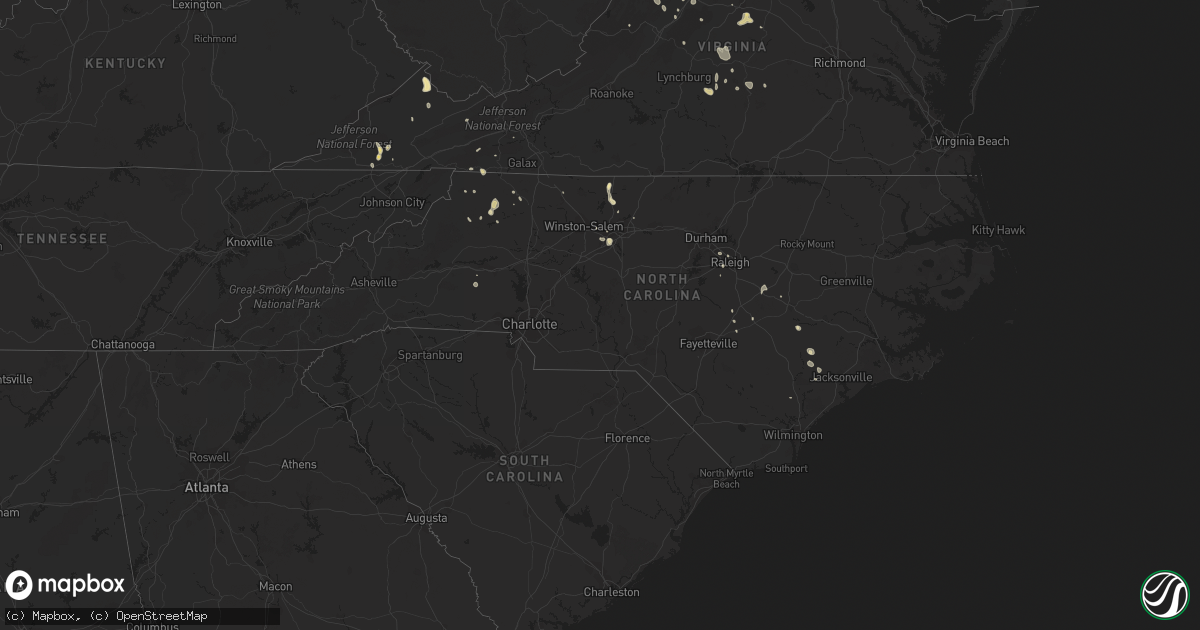
Hail Map in North Carolina on July 5, 2020
Get this storm
July 5 map
$229
one time, instant access
Download today. No call, no setup
Keep the $229
Bought the map and want the full workflow? Apply the entire $229 to a subscription within 7 days. None of it is wasted.
Every map, not just this one
This buys you this map. Subscription and you get every map we run, in the markets you choose from a few cities to whole states to nationwide. Plus real-time alerts the moment a storm fires.
Contact data
Name, contact info, occupancy, even credit band for addresses in the footprint. You go from where it hit to who to call.
Become the source they trust
Unlimited branding weather history reports on demand. You already have the documented answer ready for the property owner, and you are the one who showed up with it.
Property data and RoofTrace estimates
Pull up any address you have got, its value and the exact code rules for that jurisdiction, straight from One Click Code. Then RoofTrace estimates the squares, pitch, and roof value, priced the way you price.
Storm reports in North Carolina
North Carolina
| Date | Description |
|---|---|
| 07/05/20206:45 PM CDT | Trees down in high point at guyer/beaucrest intersection. |
| 07/05/20206:19 PM CDT | Several trees blown down along angell road near jacobs creek. |
| 07/05/20206:19 PM CDT | Several trees blown down along angell road near jacobs creek... Corrected to four miles west of bethany. |
| 07/05/20204:31 PM CDT | Power lines down at intersection of sw main st. And s. Church st. |
| 07/05/20204:30 PM CDT | Tree down at intersection of 55w and dura bilt ln. |
| 07/05/20204:13 PM CDT | Tree down at intersection of brookleaf drive and fairground rd. |
| 07/05/20203:00 PM CDT | Mostly nickel size hail with a few quarter size hail stones. Fell at residence of employee. |
| 07/05/20202:55 PM CDT | One tree blown down that is blocking one lane on route 21 close to the alleghany and wilkes county line. |
| 07/05/20202:45 PM CDT | One tree blown down along green acres road near the intersection with boone trail. |
| 07/05/20201:55 PM CDT | *** 1 fatal *** tree blown down on eddie nichols drive at the riverbend boat ramp. Person struck and killed by the tree. |
| 07/05/20201:42 PM CDT | One tree blown down along highway 16 south between vannoy construction road and buckeye lane. |
| 07/05/202012:54 PM CDT | Tree on a house power lines down at n. Hyde park ave and elmo st. |
| 07/05/20203:30 AM CDT | At 829 PM EDT, a severe thunderstorm was located near Kernersville, or near Winston-Salem, moving northwest at 15 mph. HAZARD...60 mph wind gusts. SOURCE...Radar indicated. IMPACT...Expect damage to roofs, siding, and trees. Locations impacted include... Winston-Salem, Kernersville, Walkertown, Rural Hall, Pfafftown, Stanleyville, Belews Lake, Sedge Garden and Belews Creek. |
| 07/05/20202:40 AM CDT | At 740 PM EDT, a severe thunderstorm was located over High Point, moving north at 15 mph. HAZARD...60 mph wind gusts. SOURCE...Radar indicated. IMPACT...Expect damage to roofs, siding, and trees. Locations impacted include... Greensboro, High Point, Kernersville, Jamestown, Sedge Garden, Colfax and Oak Hollow Marina. |
| 07/05/202012:04 AM CDT | At 504 PM EDT, severe thunderstorms were located along a line extending from 7 miles north of Smithfield to near Benson to near Dunn, moving northwest at 15 mph. HAZARD...60 mph wind gusts. SOURCE...Radar indicated. IMPACT...Expect damage to roofs, siding, and trees. Locations impacted include... Smithfield, Lillington, Clayton, Dunn, Angier, Benson, Micro, Selma, Erwin and Coats. |
| 07/04/202011:09 PM CDT | At 408 PM EDT, a severe thunderstorm was located near Fuquay-Varina, or 8 miles south of Cary, moving north at 10 mph. HAZARD...60 mph wind gusts. SOURCE...Radar indicated. IMPACT...Expect damage to roofs, siding, and trees. Locations impacted include... Raleigh, Cary, Garner, Fuquay-Varina, Apex, Holly Springs, Lake Wheeler, New Hill, Lake Benson and Shearon Harris Reservoir. |
| 07/04/202010:38 PM CDT | At 338 PM EDT, a severe thunderstorm was located over Halls Mills, or near Mc Grady, and is nearly stationary. HAZARD...60 mph wind gusts and quarter size hail. SOURCE...Radar indicated. IMPACT...Hail damage to vehicles is expected. Expect wind damage to roofs, siding, and trees. Locations impacted include... North Wilkesboro... Laurel Springs... Traphill... Glendale Springs... Wilbar... Mc Grady... and Mulberry. |
| 07/04/20209:23 PM CDT | At 222 PM EDT, a severe thunderstorm was located 8 miles southwest of Huntersville, or 4 miles northeast of Mt Holly, moving north at 10 mph. HAZARD...60 mph wind gusts and quarter size hail. SOURCE...Radar indicated. IMPACT...Minor hail damage to vehicles is expected. Expect wind damage to trees and power lines. Locations impacted include... Huntersville, Northwest Charlotte, Cornelius, Mt Holly, Davidson, Stanley, Westport, Paw Creek, Ramsey Creek Park and Lowesville. |
| 07/04/20208:55 PM CDT | At 154 PM EDT, a severe thunderstorm was located over Mouth Of Wilson, moving east at 10 mph. HAZARD...60 mph wind gusts and quarter size hail. SOURCE...Radar indicated. IMPACT...Hail damage to vehicles is expected. Expect wind damage to roofs, siding, and trees. Locations impacted include... Sparta... Independence... Mouth Of Wilson... Volney... Stratford... Flatridge... and Elk Creek. |
| 07/04/20208:52 PM CDT | At 152 PM EDT, a severe thunderstorm was located over Durham, and is nearly stationary. HAZARD...60 mph wind gusts. SOURCE...Radar indicated. IMPACT...Expect damage to roofs, siding, and trees. Locations impacted include... Durham, Chapel Hill, Butner, Lake Michie, Eno River State Park, Gorman, Parkwood, Bahama, Bethesda and Research Triangle. |
| 07/04/20208:15 PM CDT | Tree down on road at intersection of ebert rd and clemmonsville rd. |
| 07/04/20207:05 PM CDT | Tree down through house on 200 block of bear run lane in kernersville. |
| 07/04/20207:02 PM CDT | Tree down... Fallen across elevated cable lines on 500 block of curry rd in high point... Nc. |
All States Impacted by Hail Map on July 5, 2020
Cities Impacted by Hail Map on July 5, 2020
- Agar, SD
- Belvidere, SD
- Abilene, TX
- Newell, SD
- Capitan, NM
- Cornell, MI
- Escanaba, MI
- Bark River, MI
- Lorenzo, TX
- Kindred, ND
- Leola, SD
- Winter Garden, FL
- Hermosa, SD
- Keystone, SD
- Rapid City, SD
- Tinnie, NM
- Duluth, MN
- Ralph, SD
- Brimson, MN
- High Point, NC
- Grady, NM
- Fort Lauderdale, FL
- Pink Hill, NC
- Beulaville, NC
- Hayes, SD
- Baltimore, MD
- Dundalk, MD
- Essex, MD
- Roberts, MT
- Kadoka, SD
- Philip, SD
- Hopkinsville, KY
- Iron River, WI
- Mason, WI
- Saint Paul, MN
- Meriden, WY
- Murdo, SD
- Foxboro, WI
- Superior, WI
- Nickelsville, VA
- Granbury, TX
- Manville, WY
- Kaycee, WY
- Stoneville, NC
- Mayodan, NC
- Dundee, MS
- Mud Butte, SD
- Corydon, IN
- Verona, VA
- Mount Sidney, VA
- Staunton, VA
- Middle River, MD
- Tupelo, MS
- Saltillo, MS
- Satanta, KS
- Sublette, KS
- San Jon, NM
- Scranton, ND
- Lodgepole, SD
- Ludlow, SD
- Moorcroft, WY
- New Leipzig, ND
- Lead, SD
- Lakin, KS
- Pine Ridge, SD
- Tulare, SD
- Elizabethtown, KY
- Rineyville, KY
- Glendale, KY
- Eastview, KY
- Cecilia, KY
- Lipan, TX
- Saint Xavier, MT
- Redfield, SD
- Purlear, NC
- Fort Pierre, SD
- Nye, MT
- Roscoe, MT
- Fishtail, MT
- Red Lodge, MT
- Gillette, WY
- Belmont, MS
- Golden, MS
- Mantachie, MS
- Guntown, MS
- Baldwyn, MS
- Dennis, MS
- New Site, MS
- Burnsville, MS
- Fulton, MS
- Tishomingo, MS
- Booneville, MS
- Marietta, MS
- Garryowen, MT
- Lodge Grass, MT
- Reva, SD
- Orr, MN
- Cook, MN
- Springfield, TN
- Seven Springs, NC
- Hulett, WY
- Alzada, MT
- Jamestown, NC
- Killdeer, ND
- Dunn Center, ND
- Manning, ND
- Taylor, ND
- Halliday, ND
- Gladstone, ND
- Mott, ND
- Oakes, ND
- Fullerton, ND
- Ramer, TN
- Custer, SD
- Spearfish, SD
- Las Vegas, NM
- Loxahatchee, FL
- Rockledge, FL
- Scenic, SD
- Scottsville, VA
- Elkton, KY
- Elgin, ND
- Carson, ND
- Lidgerwood, ND
- Godwin, NC
- Hackleburg, AL
- Kilgore, TX
- Midland, SD
- Okaton, SD
- Martin, SD
- Wanblee, SD
- Liberty, KY
- Windsor, KY
- Russell Springs, KY
- Summerfield, NC
- Mentone, TX
- Harrold, SD
- Hudson, KY
- Leitchfield, KY
- Garden City, TX
- Sterling City, TX
- Drummond, WI
- Fort Supply, OK
- Buffalo, OK
- Lame Deer, MT
- Birney, MT
- Busby, MT
- Wilson, MI
- Powers, MI
- Sterling, VA
- Reston, VA
- Herndon, VA
- Marlinton, WV
- Campbellsville, KY
- Fort Smith, MT
- Fromberg, MT
- Bridger, MT
- Hill City, SD
- Bradford, AR
- Oil Trough, AR
- Gate City, VA
- Lubbock, TX
- Farmville, VA
- Kingsport, TN
- Lance Creek, WY
- Alva, WY
- Mesquite, TX
- Dallas, TX
- Garland, TX
- Grundy, VA
- Presho, SD
- Culbertson, MT
- Dunnville, KY
- Pioneer, TN
- Pilot Mountain, NC
- Lake Elmo, MN
- Danbury, WI
- Tolstoy, SD
- Bowdle, SD
- Upton, KY
- Hodgenville, KY
- Buffalo, KY
- Mount Sherman, KY
- Sonora, KY
- Magnolia, KY
- Alstead, NH
- Walpole, NH
- Lefor, ND
- Dickinson, ND
- New England, ND
- Carney, MI
- Perronville, MI
- Spalding, MI
- Osceola, AR
- Etowah, AR
- Lepanto, AR
- Pikeville, NC
- Kempner, TX
- Littlefork, MN
- Kennebec, SD
- Linden, TN
- Guernsey, WY
- Crossroads, NM
- Tatum, NM
- Stillwater, MN
- Draper, SD
- Wood, SD
- White River, SD
- Douglas, WY
- Cheyenne, WY
- West Palm Beach, FL
- Dowelltown, TN
- Curtis Bay, MD
- Clarksville, TN
- Lohn, TX
- Hayward, WI
- Ropesville, TX
- Tahoka, TX
- Edgemont, SD
- Scandia, MN
- Chisago City, MN
- Pembroke, KY
- Olmstead, KY
- Russellville, KY
- Hustonville, KY
- Cadiz, KY
- Glen Burnie, MD
- Pasadena, MD
- Fort Sumner, NM
- Cookeville, TN
- Baxter, TN
- Leoti, KS
- Cable, WI
- Weston, WY
- Devils Tower, WY
- Big Spring, TX
- Howes, SD
- Appomattox, VA
- Spout Spring, VA
- Concord, VA
- Tucumcari, NM
- Melrose, NM
- Mcalister, NM
- Wills Point, TX
- Edgewood, TX
- Fruitvale, TX
- Ranger, TX
- Overton, TX
- Henderson, TX
- Portland, TN
- House, NM
- Hohenwald, TN
- Tunica, MS
- Flasher, ND
- Marine On Saint Croix, MN
- Beulah, ND
- Mouth Of Wilson, VA
- Grassy Creek, NC
- Buckeye, WV
- New Haven, KY
- Trenton, KY
- Adams, TN
- Guthrie, KY
- Eastland, TX
- Piney Creek, NC
- Crumpler, NC
- Hinton, OK
- Hobbs, NM
- Buffalo, SD
- Lisbon, ND
- Hosmer, SD
- Weber City, VA
- Zap, ND
- Golden Valley, ND
- Sturgis, KY
- Gunpowder, MD
- Edgewood, MD
- Solon Springs, WI
- Long Lake, SD
- Froid, MT
- Pringle, SD
- Hot Springs, SD
- Buffalo Gap, SD
- Quinwood, WV
- Alexandria, TN
- Richardton, ND
- Wayland, MA
- Sudbury, MA
- Stuarts Draft, VA
- Waynesboro, VA
- Auburn, KY
- Cunningham, TN
- Cumberland Furnace, TN
- Lovington, NM
- Cary, NC
- Verona, ND
- Fort Ransom, ND
- Stirum, ND
- Gwinner, ND
- Faith, SD
- Monticello, KY
- Allensville, KY
- Dungannon, VA
- Fort Blackmore, VA
- Fall Branch, TN
- Limestone, TN
- Minong, WI
- Stow, MA
- Glen Ullin, ND
- Solen, ND
- Stanton, TX
- Tarzan, TX
- Saint Onge, SD
- Roy, NM
- Solano, NM
- Helenwood, TN
- Oneida, TN
- Stoystown, PA
- Somerset, PA
- Friedens, PA
- Abingdon, MD
- Aberdeen, MD
- Belcamp, MD
- Joppa, MD
- Dunn, NC
- Strawn, TX
- Drummonds, TN
- Selby, SD
- Java, SD
- Byers, TX
- Luray, VA
- Stanley, VA
- Hickory, NC
- Hettinger, ND
- Hitchcock, SD
- McLeansville, NC
- Grand Saline, TX
- Knott, TX
- Smithfield, NC
- Selma, NC
- San Saba, TX
- Renick, WV
- Cayuga, ND
- Huntsville, AL
- Greenville, VA
- Steeles Tavern, VA
- Morrilton, AR
- Rosedale, MD
- Raven, VA
- Oakwood, VA
- Huntsville, TN
- Palmyra, VA
- Charlottesville, VA
- Ballard, WV
- Tyler, TX
- Union Center, SD
- Hereford, TX
- Greenville, KY
- Marshall, TX
- Forbes, ND
- Evansville, WY
- Casper, WY
- Glenrock, WY
- Manter, KS
- Dickson, TN
- Breckenridge, TX
- Regent, ND
- Amidon, ND
- Electra, TX
- Nara Visa, NM
- Fort Hood, TX
- Alhambra, IL
- New Douglas, IL
- Weston, MA
- East Walpole, MA
- Wellesley, MA
- Maynard, MA
- Sharon, MA
- Medfield, MA
- Boxborough, MA
- Concord, MA
- Sherborn, MA
- Framingham, MA
- Wellesley Hills, MA
- Harvard, MA
- Acton, MA
- Walpole, MA
- Natick, MA
- Dover, MA
- Westmoreland, TN
- Lafayette, TN
- Newburyport, MA
- Newbury, MA
- White Bluff, TN
- Big Falls, MN
- Hugo, MN
- Horse Branch, KY
- Morgantown, KY
- Caneyville, KY
- Forest Lake, MN
- Crawford, NE
- Mays Landing, NJ
- Saint Jacob, IL
- Marine, IL
- Madison, NC
- Stokesdale, NC
- Sugar Grove, VA
- Franklin, KY
- Lawrenceburg, TN
- Rozet, WY
- Apex, NC
- Plains, TX
- Lismore, MN
- Kenneth, MN
- Hooversville, PA
- Bridgewater, VA
- Mount Solon, VA
- Dillwyn, VA
- Knoxville, TN
- Belle Fourche, SD
- Seminole, TX
- Wall, SD
- Arlington, VA
- Hughes, AR
- Robinsonville, MS
- Lake Cormorant, MS
- Deadwood, SD
- Traphill, NC
- Roaring River, NC
- Vale, NC
- Taiban, NM
- Erin, TN
- Sunnyvale, TX
- Lower Brule, SD
- Raleigh, NC
- Eubank, KY
- Science Hill, KY
- Petrolia, TX
- Temple, OK
- Waurika, OK
- Wichita Falls, TX
- Henrietta, TX
- Vaughn, NM
- Rockwall, TX
- New Salem, ND
- Gainesville, VA
- Nokesville, VA
- Hiltons, VA
- Bristol, VA
- Wilkesboro, NC
- Smithville, TN
- Solgohachia, AR
- Springfield, AR
- Copperas Cove, TX
- Alpha, KY
- Albany, KY
- Cotton, MN
- Clifton Forge, VA
- Wingina, VA
- Buckingham, VA
- Gladstone, VA
- Brickeys, AR
- Watersmeet, MI
- Havana, ND
- Frederick, SD
- Duff, TN
- Clairfield, TN
- Washburn, TN
- Millers Creek, NC
- Hurley, VA
- Kernersville, NC
- Belfast, TN
- Lewisburg, TN
- Elida, NM
- Hebron, ND
- Grand Chenier, LA
- Madison, VA
- Orange, VA
- Idalou, TX
- Isabella, MN
- McGrady, NC
- Ely, MN
- Dupree, SD
- Gettysburg, SD
- Jefferson, NC
- West Jefferson, NC
- Copeland, KS
- Britton, SD
- Brady, TX
- Rochelle, TX
- Owens Cross Roads, AL
- Enderlin, ND
- Hazen, ND
- Two Harbors, MN
- Eagle Butte, SD
- Jamestown, KY
- Falls Of Rough, KY
- Hardinsburg, KY
- Reeder, ND
- Aladdin, WY
- Melbourne, FL
- Merritt Island, FL
- Lebanon, KY
- Chapel Hill, TN
- Mount Crawford, VA
- Murray, KY
- Makinen, MN
- Mcleod, ND
- Edgeley, ND
- Nellysford, VA
- Roseland, VA
- Rutland, ND
- Roswell, NM
- Alvaton, KY
- Bowling Green, KY
- Scottsville, KY
- Adairville, KY
- Deep Gap, NC
- Ferguson, NC
- Boone, NC
- Sweetwater, TX
- Seney, MI
- Manistique, MI
- Roosevelt, OK
- Cogswell, ND
- Pulaski, TN
- Doole, TX
- Pierre, SD
- Chamberlain, SD
- Big Clifty, KY
- Clarkson, KY
- Indian Mound, TN
- Wentzville, MO
- Defiance, MO
- O'Fallon, MO
- Lake Saint Louis, MO
- Loudon, TN
- Greenwood Springs, MS
- Tremont, MS
- Smithville, MS
- Onida, SD
- Burkesville, KY
- Grapevine, TX
- White Plains, KY
- Crofton, KY
- Jacksboro, TN
- Manassas, VA
- Pilgrims Knob, VA
- Bolton, MA
- Chinquapin, NC
- Ulysses, KS
- North Wilkesboro, NC
- Silver Point, TN
- Buffalo Valley, TN
- Bath Springs, TN
- Prospect, TN
- Ardmore, TN
- Seagraves, TX
- Gordon, WI
- Sheldon, ND
- Lamoure, ND
- Ellsworth, NE
- Morganfield, KY
- Harrold, TX
- Middlebrook, VA
- Raphine, VA
- Charleston, TN
- Front Royal, VA
- Morton, TX
- Aberdeen Proving Ground, MD
- Manchester, KY
- Abernathy, TX
- Liberty, TN
- Nettleton, MS
- Westbrook, TX
- Watertown, TN
- Gordonsville, TN
- Crozet, VA
- Amherst, VA
- Raywick, KY
- Wessington, SD
- Lawton, OK
- Bowie, TX
- Goshen, VA
- South Heart, ND
- Mount Olive, NC
- Saginaw, MN
- Rochelle, VA
- Prospect, VA
- Kingston, TN
- Jacksboro, TX
- Riceville, TN
- McEwen, TN
- Clifton, TN
- Marianna, AR
- Friona, TX
- Vineland, NJ
- Franklin, WV
- Circleville, WV
- Glade Valley, NC
- Phelps, WI
- Richlands, NC
- Wallace, NC
- Blunt, SD
- Saint Lawrence, SD
- Havre De Grace, MD
- Harrisonburg, VA
- Broadway, VA
- Davenport, VA
- Saint Charles, MO
- Terrell, TX
- Canyon, MN
- Mooreville, MS
- Brownfield, TX
- Meadow, TX
- Wolfforth, TX
- Leavenworth, IN
- Newton Grove, NC
- Newport, AR
- Chester, VT
- Bellows Falls, VT
- Springfield, VT
- Newcastle, WY
- Wytheville, VA
- Lenoir City, TN
- Athens, TN
- Norwood, MA
- Needham, MA
- Westwood, MA
- Millis, MA
- Newport, MN
- Deerfield, VA
- Craigsville, VA
- Tannersville, VA
- Sparta, TN
- Smiths Grove, KY
- Flower Mound, TX
- Laneville, TX
- Wyndmere, ND
- Leonard, ND
- Forman, ND
- Elkin, NC
- Thurmond, NC
- Forney, TX
- Royse City, TX
- Mineral Wells, TX
- Pleasantville, NJ
- Absecon, NJ
- Egg Harbor Township, NJ
- Atlantic City, NJ
- Stafford, VA
- Quantico, VA
- Hudson, MA
- Nelson, NH
- Lake Worth, FL
- Lancaster, MA
- Floydada, TX
- Box Elder, SD
- Rowlett, TX
- Central City, KY
- Summersville, KY
- Burgaw, NC
- Spur, TX
- Crosbyton, TX
- Creston, NC
- Ovalo, TX
- Caddo, TX
- Hillsboro, WV
- Decatur, TN
- Lenorah, TX
- Fairburn, SD
- West Augusta, VA
- Walcott, ND
- Stephenson, MI
- Sparrows Point, MD
- Hialeah, FL
- Elk Creek, VA
- Langsville, OH
- Red Bay, AL
- Monterey, VA
- Arp, TX
- Troup, TX
- Rice, VA
- Aberdeen, SD
- Centerville, TN
- Saltillo, TN
- Morris Chapel, TN
- Turrell, AR
- Millington, TN
- Frenchmans Bayou, AR
- Denver City, TX
- Baird, TX
- Westport, SD
- Columbia, SD
- White Owl, SD
- Caputa, SD
- Owanka, SD
- Enning, SD
- New Underwood, SD
- Wasta, SD
- Ayer, MA
- Devens, MA
- Lincoln, MA
- Bel Air, MD
- South Range, WI
- Ashland, MT
- Greenville, ME
- Eureka, SD
- Almont, ND
- Noonan, ND
- Crosby, ND
- Columbus, ND
- Rileyville, VA


