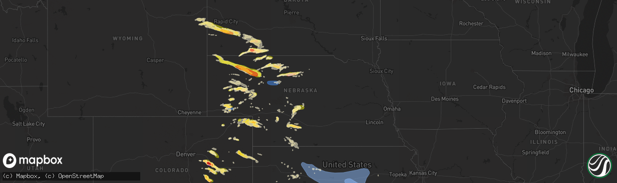
Hail Map in Nebraska on July 3, 2024
The weather event in Nebraska on July 3, 2024 includes Hail, Wind, and Tornado maps. 16 states and 364 cities were impacted and suffered possible damage. The total estimated number of properties impacted is 5,770.
Want more than just the map?
Turn this storm into a full workflow.
- Owner + property data so you know who to knock
- OnDemand branded weather history reports to win the "did we even have hail?" argument
- RoofTrace estimate so reps stop guessing numbers at the door
Bought this map? Upgrade within 7 days and we'll credit the $230. (10-15 min setup call)
Hail
Wind
Tornado
5,770
Estimated number of impacted properties by a 1.00" hail or larger770
Estimated number of impacted properties by a 1.75" hail or larger10
Estimated number of impacted properties by a 2.50" hail or largerStorm reports in Nebraska
Nebraska
| Date | Description |
|---|---|
| 07/03/20246:35 PM CDT | Weak tornado reported from custer co em. |
| 07/03/20246:14 PM CDT | Spotter report of ping pong ball sized hail. |
| 07/03/20246:10 PM CDT | Large tree limb blocking road on east side of north platte. Estimated time from radar. |
| 07/03/20245:15 PM CDT | A local report indicates 60 MPH wind near 4 NNW Kingsley Dam |
| 07/03/20244:49 PM CDT | A local report indicates 59 MPH wind near 5 SSW Oshkosh |
| 07/03/20244:30 PM CDT | Report from mping: half dollar |
| 07/03/20244:17 PM CDT | Spotter estimated quarter sized hail. Time estimated from radar. |
| 07/03/20244:02 PM CDT | Delayed report via social media. Time estimated from radar. |
| 07/03/20243:57 PM CDT | Time estimate based on radar via social media. |
| 07/03/20243:41 PM CDT | Via spotternetwork. |
| 07/03/20243:22 PM CDT | Ping pong hail reported on the west and north side of gurley. |
| 07/03/20243:01 PM CDT | A local report indicates 1.50 inch wind near 5 W Gurley |
| 07/03/20242:58 PM CDT | Trained spotter reports 1 inch to 1.25 inch hail. |
| 07/03/20242:48 PM CDT | Gurley fire chief reported ground circulation. |
| 07/03/20242:44 PM CDT | Spotter reported nickel size hail. |
| 07/03/20242:19 PM CDT | A local report indicates 1.25 inch wind near 2 W Broadwater |
| 07/03/20242:08 PM CDT | A local report indicates 1.00 inch wind near 8 SE Bridgeport |
| 07/03/20241:35 PM CDT | A local report indicates 1.00 inch wind near 24 NE Bridgeport |
| 07/02/202410:21 PM CDT | Delayed report via social media. Time estimated from radar. |
| 07/02/202410:03 PM CDT | Delayed report from social media. Time estimated from radar. |
| 07/02/20249:50 PM CDT | Roof blown off shed... Tree downed... Vehicle and crop damage from wind and hail. Time estimated by radar. Delayed report. |
| 07/02/20249:45 PM CDT | Hwy 87 covered in hail 1 mi s of hay springs. Stones measured up to quarter size. Time estimated by radar. |
| 07/02/20249:37 PM CDT | Estimated 60 mph wind gust. |
| 07/02/20249:17 PM CDT | A local report indicates 60 MPH wind near 9 SW Chadron |
| 07/02/20249:04 PM CDT | Relayed from spotter network. |
| 07/02/20248:48 PM CDT | A local report indicates 1.00 inch wind near 24 NE Harrison |
| 07/02/20248:33 PM CDT | Corrects previous tstm wnd gst report from 2 e mccook. Asos station kmck mccook airport. |
| 07/02/20248:03 PM CDT | A local report indicates 62 MPH wind near 1 E Odessa |
| 07/02/20247:58 PM CDT | A local report indicates 61 MPH wind near 6 NNE Sherman Reservoir |
| 07/02/20247:44 PM CDT | Large tree blew over in thunderstorm. |
| 07/02/20247:20 PM CDT | Delayed report via social media with approximated time. |
| 07/02/20247:05 PM CDT | A local report indicates 1.00 inch wind near 2 NW Eustis |
| 07/02/20247:03 PM CDT | Numerous large tree branches down across town. A very large tree was also uprooted. |
| 07/02/20247:02 PM CDT | Delayed report via social media. Time estimated from radar. |
All States Impacted by Hail Map on July 3, 2024
Cities Impacted by Hail Map on July 3, 2024
- Adair, IA
- Exira, IA
- Anita, IA
- Hay Springs, NE
- Rushville, NE
- Pine Ridge, SD
- Wounded Knee, SD
- Batesland, SD
- Martin, SD
- Audubon, IA
- Merriman, NE
- Tuthill, SD
- Kyle, SD
- Wanblee, SD
- Angora, NE
- Cody, NE
- Dix, NE
- Bridgeport, NE
- Valentine, NE
- Oshkosh, NE
- Potter, NE
- Fort Leonard Wood, MO
- Waynesville, MO
- Thedford, NE
- Broadwater, NE
- Porcupine, SD
- Harrisburg, NE
- Lakeside, NE
- Ellsworth, NE
- Dalton, NE
- Allen, SD
- Gurley, NE
- Shepherd, MT
- Hyannis, NE
- Bingham, NE
- Sidney, NE
- Oelrichs, SD
- Laurel, MT
- Park City, MT
- Sterling, CO
- Worden, MT
- Alliance, NE
- Johnstown, NE
- Whitman, NE
- Lewellen, NE
- Edgemont, SD
- Custer, SD
- Lisco, NE
- Saint Francis, SD
- Ashby, NE
- Mullen, NE
- Wood Lake, NE
- Arthur, NE
- Willow Springs, MO
- Winslow, IN
- Upton, WY
- Moorcroft, WY
- Sundance, WY
- Ironton, MO
- Osage, WY
- Fleming, CO
- Haxtun, CO
- Newcastle, WY
- Jasper, IN
- Otwell, IN
- Lesterville, MO
- Rye, CO
- Bennett, CO
- Fredericktown, MO
- Annapolis, MO
- Arcadia, MO
- Walsenburg, CO
- Fort Myers, FL
- Deer Trail, CO
- Lodgepole, NE
- Velpen, IN
- Cabool, MO
- Cascade, MT
- Hill City, SD
- Des Moines, NM
- Sedgwick, CO
- Woodrow, CO
- Solo, MO
- Elk Creek, MO
- Folsom, NM
- Cape Coral, FL
- Perryville, MO
- Ovid, CO
- Pueblo, CO
- Fort Morgan, CO
- Byers, CO
- Crook, CO
- Iliff, CO
- Akron, CO
- Otis, CO
- Patton, MO
- Houston, MO
- Julesburg, CO
- Model, CO
- Fowler, CO
- Lake Park, GA
- Marquand, MO
- Sedgewickville, MO
- Greenville, MO
- Agate, CO
- Kim, CO
- Uniontown, MO
- Frohna, MO
- Jackson, MO
- Oak Ridge, MO
- Altenburg, MO
- Valdosta, GA
- Sutherland, NE
- Lemoyne, NE
- Glenallen, MO
- Keystone, SD
- Hermosa, SD
- Ogallala, NE
- Micanopy, FL
- Hawthorne, FL
- Williamsville, MO
- Keystone, NE
- Mill Spring, MO
- Curtis, NE
- Rapid City, SD
- Fairburn, SD
- Ramah, CO
- Yuma, CO
- Ainsworth, NE
- Maxwell, NE
- Moorefield, NE
- Simla, CO
- Genoa, CO
- Farnam, NE
- Joes, CO
- Limon, CO
- Wolf Lake, IL
- Doniphan, MO
- Santa Fe, NM
- Stapleton, NE
- Venango, NE
- Patterson, MO
- Brady, NE
- Ellsinore, MO
- Rocky Ford, CO
- Hershey, NE
- North Platte, NE
- Swink, CO
- La Junta, CO
- Trinidad, CO
- Las Animas, CO
- Alto Pass, IL
- Kirk, CO
- Gothenburg, NE
- Amherst, CO
- Grandin, MO
- Dickens, NE
- Claremore, OK
- Cobden, IL
- Matheson, CO
- Manzanola, CO
- Cheraw, CO
- Champion, NE
- Imperial, NE
- Eustis, NE
- Bassett, NE
- Idalia, CO
- Arnold, NE
- Scenic, SD
- Elsie, NE
- Makanda, IL
- Holyoke, CO
- Grant, NE
- Flagler, CO
- Callaway, NE
- Broken Bow, NE
- Calhan, CO
- Bradleyville, MO
- Ava, MO
- Seibert, CO
- Hugo, CO
- Rush, CO
- Merna, NE
- Arriba, CO
- Pryor, OK
- Poplar Bluff, MO
- Fairview, MO
- Belknap, IL
- Elwood, NE
- Lamar, CO
- Hasty, CO
- McClave, CO
- Wiley, CO
- Holly, CO
- Sugar City, CO
- Kanorado, KS
- Saint Francis, KS
- Burlington, CO
- Francisco, IN
- Princeton, IN
- Yoder, CO
- Keyes, OK
- Dalhart, TX
- Purdy, MO
- Goodland, KS
- Wauneta, NE
- Monett, MO
- Cassville, MO
- Goodwell, OK
- Richfield, KS
- Aurora, MO
- Verona, MO
- Syracuse, KS
- Bird City, KS
- Cape Fair, MO
- Galena, MO
- Chelsea, OK
- Shell Knob, MO
- Oxly, MO
- Stockville, NE
- Reeds Spring, MO
- Naylor, MO
- Lexington, NE
- Neelyville, MO
- McCook, NE
- Blue Eye, MO
- Branson, MO
- Harrison, NE
- Indianola, NE
- Hollister, MO
- Conchas Dam, NM
- Deerfield, KS
- Crawford, NE
- Marienthal, KS
- Holcomb, KS
- Rexford, KS
- Whitney, NE
- Danbury, NE
- Oberlin, KS
- Lebanon, NE
- Bartley, NE
- Wilsonville, NE
- Scott City, KS
- Selden, KS
- Chadron, NE
- Hoxie, KS
- Oakley, KS
- Norcatur, KS
- Winona, KS
- Healy, KS
- Norton, KS
- Gove, KS
- Quinter, KS
- Park, KS
- Grainfield, KS
- Collyer, KS
- Gordon, NE
- Wakeeney, KS
- Texhoma, OK
- Guymon, OK
- Palco, KS
- Plainville, KS
- Stratford, TX
- Natoma, KS
- Ellis, KS
- Paradise, KS
- Hemingford, NE
- Hardesty, OK
- Bayard, NE
- El Dorado, KS
- Potwin, KS
- Burns, KS
- Durham, KS
- Junction City, KS
- Alta Vista, KS
- Thornfield, MO
- Kirbyville, MO
- Bennington, KS
- Damar, KS
- Sedgwick, KS
- Burrton, KS
- Lorraine, KS
- Salina, KS
- Inman, KS
- Falun, KS
- Minneapolis, KS
- Lincoln, KS
- Sterling, KS
- Abilene, KS
- Hutchinson, KS
- North Newton, KS
- Windom, KS
- Hesston, KS
- Talmage, KS
- Chase, KS
- Wilson, KS
- Peabody, KS
- Claflin, KS
- Solomon, KS
- Waldo, KS
- Partridge, KS
- Walton, KS
- Ellinwood, KS
- Dorrance, KS
- Chapman, KS
- Canton, KS
- Lindsborg, KS
- Little River, KS
- Bunker Hill, KS
- South Hutchinson, KS
- Tescott, KS
- Gorham, KS
- Abbyville, KS
- Enterprise, KS
- Tampa, KS
- Catharine, KS
- Walker, KS
- Buhler, KS
- Roxbury, KS
- Nickerson, KS
- Raymond, KS
- Newton, KS
- Barnard, KS
- Pretty Prairie, KS
- Assaria, KS
- Russell, KS
- Gypsum, KS
- Goessel, KS
- Milford, KS
- Marquette, KS
- Hays, KS
- Mount Hope, KS
- Geneseo, KS
- Galva, KS
- Lehigh, KS
- Arlington, KS
- Hill City, KS
- Bogue, KS
- Beverly, KS
- Hillsboro, KS
- Sylvan Grove, KS
- Penokee, KS
- Hope, KS
- Mcpherson, KS
- New Cambria, KS
- Brookville, KS
- Halstead, KS
- Bushton, KS
- Ellsworth, KS
- Lyons, KS
- Holyrood, KS
- Hoisington, KS
- Clay Center, KS
- Victoria, KS
- Haven, KS
- Kanopolis, KS
- Lucas, KS
- Luray, KS
- Marion, KS
- Longford, KS
- Wakefield, KS
- Moundridge, KS
- Stockton, KS
- Overton, NE


