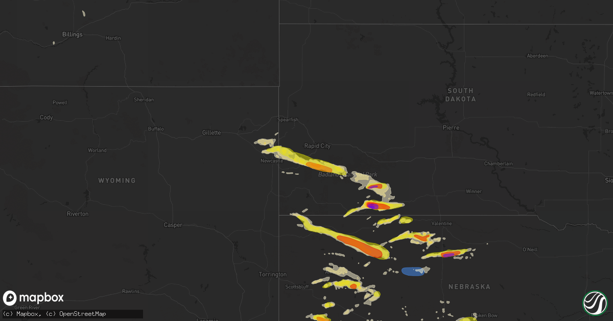
Hail Map on July 3, 2024
Get this storm
July 3 map
$229
one time, instant access
Download today. No call, no setup
Keep the $229
Bought the map and want the full workflow? Apply the entire $229 to a subscription within 7 days. None of it is wasted.
Every map, not just this one
This buys you this map. Subscription and you get every map we run, in the markets you choose from a few cities to whole states to nationwide. Plus real-time alerts the moment a storm fires.
Contact data
Name, contact info, occupancy, even credit band for addresses in the footprint. You go from where it hit to who to call.
Become the source they trust
Unlimited branding weather history reports on demand. You already have the documented answer ready for the property owner, and you are the one who showed up with it.
Property data and RoofTrace estimates
Pull up any address you have got, its value and the exact code rules for that jurisdiction, straight from One Click Code. Then RoofTrace estimates the squares, pitch, and roof value, priced the way you price.
States Impacted by Hail Map on July 3, 2024
Storm reports
New Mexico
| Date | Description |
|---|---|
| 07/03/20246:46 PM CDT | Downburst wind gust. Asos station krtn raton crews airport. |
Kansas
| Date | Description |
|---|---|
| 07/03/20242:00 AM CDT | A local report indicates 59 MPH wind near 2 NE Maize |
| 07/03/20241:59 AM CDT | A local report indicates 60 MPH wind near Sedgwick |
| 07/03/20241:42 AM CDT | Large tree uprooted. |
| 07/03/20241:25 AM CDT | A local report indicates 59 MPH wind near 1 SW Hillsboro |
| 07/03/20241:15 AM CDT | A local report indicates 58 MPH wind near 3 E Hutchinson |
| 07/03/20241:13 AM CDT | A local report indicates 63 MPH wind near 4 S Durham |
| 07/03/20241:09 AM CDT | A local report indicates 58 MPH wind near 6 N Moundridge |
| 07/03/20241:09 AM CDT | A local report indicates 67 MPH wind near 5 ESE Partridge |
| 07/03/20241:09 AM CDT | A local report indicates 72 MPH wind near 1 W Canton |
| 07/03/20241:05 AM CDT | A local report indicates 76 MPH wind near 1 S Mcpherson |
| 07/03/20241:04 AM CDT | A local report indicates 58 MPH wind near 1 W Canton |
| 07/03/20241:00 AM CDT | A local report indicates 59 MPH wind near 1 NE Inman |
| 07/03/202412:58 AM CDT | Delayed report of tree limbs 4 inches in diameter blown down and a dumpster was blown over onto a train track. Power is out for part of the area. |
| 07/03/202412:57 AM CDT | Awos station kk78 abilene. |
| 07/03/202412:57 AM CDT | A local report indicates 60 MPH wind near 6 ESE Inman |
| 07/03/202412:55 AM CDT | A local report indicates 62 MPH wind near 2 SW Mcpherson |
| 07/03/202412:52 AM CDT | A local report indicates 69 MPH wind near Lindsborg |
| 07/03/202412:51 AM CDT | A local report indicates 75 MPH wind near 3 E Mcpherson |
| 07/03/202412:43 AM CDT | 4 to 5 inch diameter limbs also reported down. |
| 07/03/202412:42 AM CDT | A local report indicates 58 MPH wind near 5 SE Lyons |
| 07/03/202412:38 AM CDT | Asos station ksln salina regional airport. |
| 07/03/202412:35 AM CDT | A local report indicates 61 MPH wind near 2 W Little River |
| 07/03/202412:33 AM CDT | Asos station ksln salina regional airport. |
| 07/03/202412:33 AM CDT | A local report indicates 70 MPH wind near 8 WNW Marquette |
| 07/03/202412:27 AM CDT | Estimated 55-65mph wind gusts. |
| 07/03/202412:14 AM CDT | A local report indicates 73 MPH wind near 6 ENE Kanopolis |
| 07/03/202412:08 AM CDT | Also reported 0.85 inches of rain in 15 minutes. |
| 07/03/202412:05 AM CDT | Report of a house with part of the roof blown off about 5 miles northeast of ellsworth. Also... Tree limbs down in the town of ellsworth. Delayed report. Report relayed |
| 07/03/202412:00 AM CDT | Also reported an 8 inch diameter limb down. |
| 07/02/202411:58 PM CDT | A local report indicates 70 MPH wind near 3 SE Sylvan Grove |
| 07/02/202411:51 PM CDT | A local report indicates 60 MPH wind near 4 ESE Wilson |
| 07/02/202411:45 PM CDT | *** 1 fatal... 3 inj *** campers blown over from high winds at lake wilson. Updated information from russell county sheriff press release. |
| 07/02/202411:45 PM CDT | Report of multiple campers blown over at wilson lake. |
| 07/02/202411:34 PM CDT | A local report indicates 60 MPH wind near 3 NNE Bunker Hill |
| 07/02/202411:33 PM CDT | A local report indicates 70 MPH wind near Russell Airport |
| 07/02/202411:32 PM CDT | A local report indicates 68 MPH wind near Russell |
| 07/02/202411:01 PM CDT | Awos station khys hays regional airport awos site. |
| 07/02/202410:35 PM CDT | The asos in hill city |
| 07/02/202410:24 PM CDT | The asos in hill city |
| 07/02/202410:22 PM CDT | The asos in hill city |
| 07/02/20249:30 PM CDT | Many three and a half inch diameter green tree limbs blown down. Estimated time of report from radar. |
| 07/02/20249:14 PM CDT | Pws-kksselde4 wuunderground station. |
Wyoming
| Date | Description |
|---|---|
| 07/03/20245:46 PM CDT | Mesonet station wy2 4.7 se aberdeen |
| 07/03/20243:46 PM CDT | A local report indicates 1.00 inch wind near 10 NNE Osage |
South Dakota
| Date | Description |
|---|---|
| 07/03/20246:45 PM CDT | A local report indicates 60 MPH wind near 14 NNE Rockyford |
| 07/03/20245:40 PM CDT | Reported damage from hail |
| 07/03/20245:40 PM CDT | A local report indicates 1.50 inch wind near 4 NNW Fairburn |
| 07/03/20245:38 PM CDT | A local report indicates 1.00 inch wind near 6 W Hermosa |
| 07/03/20245:37 PM CDT | A local report indicates 65 MPH wind near 5 NNW Fairburn |
| 07/03/20245:12 PM CDT | A local report indicates 1.25 inch wind near 5 NNW Custer |
| 07/03/20245:11 PM CDT | A local report indicates 1.00 inch wind near 3 SSW Hill City |
| 07/03/20244:37 PM CDT | A local report indicates 1.00 inch wind near 6 SW Deerfield |
| 07/03/20244:34 PM CDT | A local report indicates 1.00 inch wind near 6 SW Deerfield |
| 07/03/20243:16 PM CDT | A local report indicates 1.50 inch wind near 5 W Martin |
| 07/03/20242:58 PM CDT | Combined with 50mph winds |
| 07/03/20242:50 PM CDT | A local report indicates 1.75 inch wind near 3 WSW Swett |
| 07/03/20242:35 PM CDT | Mostly golf ball size with a few baseball. |
Colorado
| Date | Description |
|---|---|
| 07/03/20246:47 PM CDT | Mesonet station dw6957 walsh. |
| 07/03/20246:42 PM CDT | Trained spotter reports estimated 60 mph winds 4s of idalia and some pea sized hail. |
| 07/03/20246:40 PM CDT | Caller estimated 60 mph gust. Time radar estimated. |
| 07/03/20246:25 PM CDT | Large tree limbs blown down with minor damage to camping trailers from limb impalement. |
| 07/03/20246:23 PM CDT | Asos station klic limon. |
| 07/03/20246:10 PM CDT | Caller reported several healthy american elm tree branches snapped off the tree. Limbs were estimated to be 4 inches in diameter. Time estimated via caller and radar. |
| 07/03/20246:04 PM CDT | Report from mping: baseball++ |
| 07/03/20246:02 PM CDT | Report from mping: baseball |
| 07/03/20246:01 PM CDT | A local report indicates 2.65 inch wind near 3 W Cedar Point |
| 07/03/20245:53 PM CDT | Asos station klhx la junta airport. |
| 07/03/20245:46 PM CDT | Spotter at location and time reported ongoing quarter size hail. |
| 07/03/20245:36 PM CDT | Report from mping: half dollar |
| 07/03/20245:16 PM CDT | Report from mping: half dollar |
| 07/03/20245:15 PM CDT | Mesonet station fw4234 fowler. |
| 07/03/20245:05 PM CDT | A local report indicates 1.75 inch wind near 8 SW Deer Trail |
| 07/03/20244:58 PM CDT | A local report indicates 1.00 inch wind near 5 ESE Twin Buttes |
| 07/03/20244:54 PM CDT | Report from mping: quarter |
| 07/03/20244:07 PM CDT | Mesonet station co029 025s066 ap |
| 07/03/20244:07 PM CDT | Mesonet station co029 025s066 apache city. |
| 07/03/20243:29 PM CDT | Delayed report from trained spotter. Most hailstones were smaller than 1 inch in diameter. |
| 07/02/20247:50 PM CDT | Reports via twitter. |
| 07/02/20247:40 PM CDT | Report via x. |
| 07/02/20247:09 PM CDT | Picture of hail measuring 1.65 inches in diameter via social media. |
| 07/02/20247:04 PM CDT | Hail reported from 604 pm through 626 pm. |
Missouri
| Date | Description |
|---|---|
| 07/03/20245:50 PM CDT | Late report. Tree down in greenville reported by 911 dispatch center. Time estimated by radar. |
| 07/03/20245:35 PM CDT | Tree down on grandview dr. |
| 07/02/20248:14 PM CDT | Mping report of 1 inch hail. |
| 07/02/20248:10 PM CDT | Awos station kfwb branson west awos. |
| 07/02/20248:09 PM CDT | Time indicated by radar. Photo report from public on social media. |
| 07/02/20248:06 PM CDT | Mping report of 1 inch hail. |
| 07/02/20248:05 PM CDT | A local report indicates 1.75 inch wind near 3 W West Branson |
| 07/02/20248:02 PM CDT | Widespread 6 inch to 8 inch limbs down on ance creek road west of branson west. Large trees down in places with minor home damage. |
| 07/02/20247:58 PM CDT | Several pictures and reports of baseball to three inch hail in cape fair. |
| 07/02/20247:56 PM CDT | Damage at the dock/marina. Unknown extent at this time. Trees down in the area. |
| 07/02/20247:55 PM CDT | Numerous trees down. |
| 07/02/20247:52 PM CDT | Thunderstorm winds ranging from 70 to 80 mph produced damage to marina with a portion breaking away from mooring. Dock a sustained most damage. Tree branches broken... |
| 07/02/20247:50 PM CDT | Collapse of a 280 feet free standing cell phone tower. No debris lofted around home or tower. Strongest winds near 100 mph remained at tower height. Tower built on elev |
| 07/02/20247:48 PM CDT | Trees down over roadway. |
Oklahoma
| Date | Description |
|---|---|
| 07/02/202410:54 PM CDT | A local report indicates 61 MPH wind near 1 WSW Guymon |
| 07/02/202410:50 PM CDT | A local report indicates 63 MPH wind near 2 ENE Goodwell |
| 07/02/202410:45 PM CDT | A local report indicates 60 MPH wind near 2 ENE Goodwell |
Nebraska
| Date | Description |
|---|---|
| 07/03/20246:35 PM CDT | Weak tornado reported from custer co em. |
| 07/03/20246:14 PM CDT | Spotter report of ping pong ball sized hail. |
| 07/03/20246:10 PM CDT | Large tree limb blocking road on east side of north platte. Estimated time from radar. |
| 07/03/20245:15 PM CDT | A local report indicates 60 MPH wind near 4 NNW Kingsley Dam |
| 07/03/20244:49 PM CDT | A local report indicates 59 MPH wind near 5 SSW Oshkosh |
| 07/03/20244:30 PM CDT | Report from mping: half dollar |
| 07/03/20244:17 PM CDT | Spotter estimated quarter sized hail. Time estimated from radar. |
| 07/03/20244:02 PM CDT | Delayed report via social media. Time estimated from radar. |
| 07/03/20243:57 PM CDT | Time estimate based on radar via social media. |
| 07/03/20243:41 PM CDT | Via spotternetwork. |
| 07/03/20243:22 PM CDT | Ping pong hail reported on the west and north side of gurley. |
| 07/03/20243:01 PM CDT | A local report indicates 1.50 inch wind near 5 W Gurley |
| 07/03/20242:58 PM CDT | Trained spotter reports 1 inch to 1.25 inch hail. |
| 07/03/20242:48 PM CDT | Gurley fire chief reported ground circulation. |
| 07/03/20242:44 PM CDT | Spotter reported nickel size hail. |
| 07/03/20242:19 PM CDT | A local report indicates 1.25 inch wind near 2 W Broadwater |
| 07/03/20242:08 PM CDT | A local report indicates 1.00 inch wind near 8 SE Bridgeport |
| 07/03/20241:35 PM CDT | A local report indicates 1.00 inch wind near 24 NE Bridgeport |
| 07/02/202410:21 PM CDT | Delayed report via social media. Time estimated from radar. |
| 07/02/202410:03 PM CDT | Delayed report from social media. Time estimated from radar. |
| 07/02/20249:50 PM CDT | Roof blown off shed... Tree downed... Vehicle and crop damage from wind and hail. Time estimated by radar. Delayed report. |
| 07/02/20249:45 PM CDT | Hwy 87 covered in hail 1 mi s of hay springs. Stones measured up to quarter size. Time estimated by radar. |
| 07/02/20249:37 PM CDT | Estimated 60 mph wind gust. |
| 07/02/20249:17 PM CDT | A local report indicates 60 MPH wind near 9 SW Chadron |
| 07/02/20249:04 PM CDT | Relayed from spotter network. |
| 07/02/20248:48 PM CDT | A local report indicates 1.00 inch wind near 24 NE Harrison |
| 07/02/20248:33 PM CDT | Corrects previous tstm wnd gst report from 2 e mccook. Asos station kmck mccook airport. |
| 07/02/20248:03 PM CDT | A local report indicates 62 MPH wind near 1 E Odessa |
| 07/02/20247:58 PM CDT | A local report indicates 61 MPH wind near 6 NNE Sherman Reservoir |
| 07/02/20247:44 PM CDT | Large tree blew over in thunderstorm. |
| 07/02/20247:20 PM CDT | Delayed report via social media with approximated time. |
| 07/02/20247:05 PM CDT | A local report indicates 1.00 inch wind near 2 NW Eustis |
| 07/02/20247:03 PM CDT | Numerous large tree branches down across town. A very large tree was also uprooted. |
| 07/02/20247:02 PM CDT | Delayed report via social media. Time estimated from radar. |
Indiana
| Date | Description |
|---|---|
| 07/03/20244:04 PM CDT | Trees and powerlines came down. |
| 07/02/20247:00 PM CDT | Tree down on power line on south 2nd street. |
Texas
| Date | Description |
|---|---|
| 07/02/202411:59 PM CDT | A local report indicates 58 MPH wind near 4 E Perryton |
| 07/02/202411:30 PM CDT | A local report indicates 60 MPH wind near 1 NW Palo Duro Reservoi |
Cities Impacted by Hail Map on July 3, 2024
- Adair, IA
- Exira, IA
- Anita, IA
- Hay Springs, NE
- Rushville, NE
- Pine Ridge, SD
- Wounded Knee, SD
- Batesland, SD
- Martin, SD
- Audubon, IA
- Merriman, NE
- Tuthill, SD
- Kyle, SD
- Wanblee, SD
- Angora, NE
- Cody, NE
- Dix, NE
- Bridgeport, NE
- Valentine, NE
- Oshkosh, NE
- Potter, NE
- Fort Leonard Wood, MO
- Waynesville, MO
- Thedford, NE
- Broadwater, NE
- Porcupine, SD
- Harrisburg, NE
- Lakeside, NE
- Ellsworth, NE
- Dalton, NE
- Allen, SD
- Gurley, NE
- Shepherd, MT
- Hyannis, NE
- Bingham, NE
- Sidney, NE
- Oelrichs, SD
- Laurel, MT
- Park City, MT
- Sterling, CO
- Worden, MT
- Alliance, NE
- Johnstown, NE
- Whitman, NE
- Lewellen, NE
- Edgemont, SD
- Custer, SD
- Lisco, NE
- Saint Francis, SD
- Ashby, NE
- Mullen, NE
- Wood Lake, NE
- Arthur, NE
- Willow Springs, MO
- Winslow, IN
- Upton, WY
- Moorcroft, WY
- Sundance, WY
- Ironton, MO
- Osage, WY
- Fleming, CO
- Haxtun, CO
- Newcastle, WY
- Jasper, IN
- Otwell, IN
- Lesterville, MO
- Rye, CO
- Bennett, CO
- Fredericktown, MO
- Annapolis, MO
- Arcadia, MO
- Walsenburg, CO
- Fort Myers, FL
- Deer Trail, CO
- Lodgepole, NE
- Velpen, IN
- Cabool, MO
- Cascade, MT
- Hill City, SD
- Des Moines, NM
- Sedgwick, CO
- Woodrow, CO
- Solo, MO
- Elk Creek, MO
- Folsom, NM
- Cape Coral, FL
- Perryville, MO
- Ovid, CO
- Pueblo, CO
- Fort Morgan, CO
- Byers, CO
- Crook, CO
- Iliff, CO
- Akron, CO
- Otis, CO
- Patton, MO
- Houston, MO
- Julesburg, CO
- Model, CO
- Fowler, CO
- Lake Park, GA
- Marquand, MO
- Sedgewickville, MO
- Greenville, MO
- Agate, CO
- Kim, CO
- Uniontown, MO
- Frohna, MO
- Jackson, MO
- Oak Ridge, MO
- Altenburg, MO
- Valdosta, GA
- Sutherland, NE
- Lemoyne, NE
- Glenallen, MO
- Keystone, SD
- Hermosa, SD
- Ogallala, NE
- Micanopy, FL
- Hawthorne, FL
- Williamsville, MO
- Keystone, NE
- Mill Spring, MO
- Curtis, NE
- Rapid City, SD
- Fairburn, SD
- Ramah, CO
- Yuma, CO
- Ainsworth, NE
- Maxwell, NE
- Moorefield, NE
- Simla, CO
- Genoa, CO
- Farnam, NE
- Joes, CO
- Limon, CO
- Wolf Lake, IL
- Doniphan, MO
- Santa Fe, NM
- Stapleton, NE
- Venango, NE
- Patterson, MO
- Brady, NE
- Ellsinore, MO
- Rocky Ford, CO
- Hershey, NE
- North Platte, NE
- Swink, CO
- La Junta, CO
- Trinidad, CO
- Las Animas, CO
- Alto Pass, IL
- Kirk, CO
- Gothenburg, NE
- Amherst, CO
- Grandin, MO
- Dickens, NE
- Claremore, OK
- Cobden, IL
- Matheson, CO
- Manzanola, CO
- Cheraw, CO
- Champion, NE
- Imperial, NE
- Eustis, NE
- Bassett, NE
- Idalia, CO
- Arnold, NE
- Scenic, SD
- Elsie, NE
- Makanda, IL
- Holyoke, CO
- Grant, NE
- Flagler, CO
- Callaway, NE
- Broken Bow, NE
- Calhan, CO
- Bradleyville, MO
- Ava, MO
- Seibert, CO
- Hugo, CO
- Rush, CO
- Merna, NE
- Arriba, CO
- Pryor, OK
- Poplar Bluff, MO
- Fairview, MO
- Belknap, IL
- Elwood, NE
- Lamar, CO
- Hasty, CO
- McClave, CO
- Wiley, CO
- Holly, CO
- Sugar City, CO
- Kanorado, KS
- Saint Francis, KS
- Burlington, CO
- Francisco, IN
- Princeton, IN
- Yoder, CO
- Keyes, OK
- Dalhart, TX
- Purdy, MO
- Goodland, KS
- Wauneta, NE
- Monett, MO
- Cassville, MO
- Goodwell, OK
- Richfield, KS
- Aurora, MO
- Verona, MO
- Syracuse, KS
- Bird City, KS
- Cape Fair, MO
- Galena, MO
- Chelsea, OK
- Shell Knob, MO
- Oxly, MO
- Stockville, NE
- Reeds Spring, MO
- Naylor, MO
- Lexington, NE
- Neelyville, MO
- McCook, NE
- Blue Eye, MO
- Branson, MO
- Harrison, NE
- Indianola, NE
- Hollister, MO
- Conchas Dam, NM
- Deerfield, KS
- Crawford, NE
- Marienthal, KS
- Holcomb, KS
- Rexford, KS
- Whitney, NE
- Danbury, NE
- Oberlin, KS
- Lebanon, NE
- Bartley, NE
- Wilsonville, NE
- Scott City, KS
- Selden, KS
- Chadron, NE
- Hoxie, KS
- Oakley, KS
- Norcatur, KS
- Winona, KS
- Healy, KS
- Norton, KS
- Gove, KS
- Quinter, KS
- Park, KS
- Grainfield, KS
- Collyer, KS
- Gordon, NE
- Wakeeney, KS
- Texhoma, OK
- Guymon, OK
- Palco, KS
- Plainville, KS
- Stratford, TX
- Natoma, KS
- Ellis, KS
- Paradise, KS
- Hemingford, NE
- Hardesty, OK
- Bayard, NE
- El Dorado, KS
- Potwin, KS
- Burns, KS
- Durham, KS
- Junction City, KS
- Alta Vista, KS
- Thornfield, MO
- Kirbyville, MO
- Bennington, KS
- Damar, KS
- Sedgwick, KS
- Burrton, KS
- Lorraine, KS
- Salina, KS
- Inman, KS
- Falun, KS
- Minneapolis, KS
- Lincoln, KS
- Sterling, KS
- Abilene, KS
- Hutchinson, KS
- North Newton, KS
- Windom, KS
- Hesston, KS
- Talmage, KS
- Chase, KS
- Wilson, KS
- Peabody, KS
- Claflin, KS
- Solomon, KS
- Waldo, KS
- Partridge, KS
- Walton, KS
- Ellinwood, KS
- Dorrance, KS
- Chapman, KS
- Canton, KS
- Lindsborg, KS
- Little River, KS
- Bunker Hill, KS
- South Hutchinson, KS
- Tescott, KS
- Gorham, KS
- Abbyville, KS
- Enterprise, KS
- Tampa, KS
- Catharine, KS
- Walker, KS
- Buhler, KS
- Roxbury, KS
- Nickerson, KS
- Raymond, KS
- Newton, KS
- Barnard, KS
- Pretty Prairie, KS
- Assaria, KS
- Russell, KS
- Gypsum, KS
- Goessel, KS
- Milford, KS
- Marquette, KS
- Hays, KS
- Mount Hope, KS
- Geneseo, KS
- Galva, KS
- Lehigh, KS
- Arlington, KS
- Hill City, KS
- Bogue, KS
- Beverly, KS
- Hillsboro, KS
- Sylvan Grove, KS
- Penokee, KS
- Hope, KS
- Mcpherson, KS
- New Cambria, KS
- Brookville, KS
- Halstead, KS
- Bushton, KS
- Ellsworth, KS
- Lyons, KS
- Holyrood, KS
- Hoisington, KS
- Clay Center, KS
- Victoria, KS
- Haven, KS
- Kanopolis, KS
- Lucas, KS
- Luray, KS
- Marion, KS
- Longford, KS
- Wakefield, KS
- Moundridge, KS
- Stockton, KS
- Overton, NE