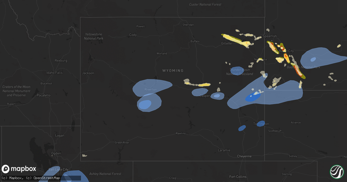
Hail Map in Wyoming on July 3, 2023
Get this storm
July 3 map
$229
one time, instant access
Download today. No call, no setup
Keep the $229
Bought the map and want the full workflow? Apply the entire $229 to a subscription within 7 days. None of it is wasted.
Every map, not just this one
This buys you this map. Subscription and you get every map we run, in the markets you choose from a few cities to whole states to nationwide. Plus real-time alerts the moment a storm fires.
Contact data
Name, contact info, occupancy, even credit band for addresses in the footprint. You go from where it hit to who to call.
Become the source they trust
Unlimited branding weather history reports on demand. You already have the documented answer ready for the property owner, and you are the one who showed up with it.
Property data and RoofTrace estimates
Pull up any address you have got, its value and the exact code rules for that jurisdiction, straight from One Click Code. Then RoofTrace estimates the squares, pitch, and roof value, priced the way you price.
Storm reports in Wyoming
Wyoming
| Date | Description |
|---|---|
| 07/03/20236:50 PM CDT | Camp creek raws. |
| 07/03/20236:41 PM CDT | Asos station krwl 1 ene rawlins. |
| 07/03/20236:15 PM CDT | Mesonet station fw5226 shoshoni. |
| 07/03/20236:15 PM CDT | Mesonet station camw4 muddy gap 7 sw. Raws sensors report on the hour... So estimated time based on gust front arrival for nearby sensors. |
| 07/03/20236:08 PM CDT | Asos station kriw riverton airport. |
| 07/03/20236:06 PM CDT | Mesonet station kbvr beaver rim |
| 07/03/20235:55 PM CDT | A number of tree limbs broke and down. |
| 07/03/20235:53 PM CDT | Asos station klnd lander airport. |
| 07/03/20235:50 PM CDT | Mesonet station andw4 south pass city 8 w. |
| 07/03/20235:46 PM CDT | Corrects previous non-tstm wnd gst report from 10 ne atlantic city... As it was with a thunderstorm. Local terrain funnels wind at this location. Mesonet station krec r |
| 07/03/20235:45 PM CDT | Mesonet station fw3817 kinnear. |
| 07/03/20235:39 PM CDT | Asos station klnd lander airport. |
| 07/03/20235:20 PM CDT | Mesonet sensor. |
| 07/03/20234:42 PM CDT | Mesonet station wy42 farson |
| 07/03/20234:40 PM CDT | Mesonet station pc280 riverside. |
| 07/03/20234:15 PM CDT | About 30 percent of commercial warehouse building tin roof torn back by strong wind. |
| 07/03/20234:13 PM CDT | Asos station kbpi big piney airport. |
| 07/03/20233:45 PM CDT | Mesonet station tetwy teton saddle. |
| 07/02/202311:32 PM CDT | Mesonet station kbvr beaver rim |
| 07/02/202311:32 PM CDT | Mesonet station kctd wamsutter 10.5 e |
| 07/02/202311:26 PM CDT | Mesonet station krec red canyon - south pass. Wind funnels through this gap. This is the second round of thunderstorms to move through today. |
| 07/02/202311:15 PM CDT | A local report indicates 60 MPH wind near 4 SSE Pine Haven |
| 07/02/202310:42 PM CDT | Mostly marble hail with a few quarters |
| 07/02/202310:30 PM CDT | Mostly smaller hail with a few up to an inch. Heavy rainfall. |
| 07/02/202310:17 PM CDT | Asos station krks rock springs airport. |
| 07/02/202310:05 PM CDT | A local report indicates 61 MPH wind near 25 ESE Wright |
| 07/02/202310:00 PM CDT | A local report indicates 1.50 inch wind near 4 ESE Pine Haven |
| 07/02/20239:30 PM CDT | A local report indicates 1.00 inch wind near 13 SE Weston |
| 07/02/20239:23 PM CDT | Asos station ktor torrington airport - tor. |
| 07/02/20239:14 PM CDT | Em estimated winds of 70 to 80 mph across the town of lusk. |
| 07/02/20239:14 PM CDT | 80' cedar tree reported broken in half. |
| 07/02/20239:10 PM CDT | Caller estimated 60 mph with the front edge of the line of storms. |
| 07/02/20239:10 PM CDT | Spotter estimated 50 to 60 mph wind gust. |
| 07/02/20238:45 PM CDT | A local report indicates 1.75 inch wind near Wright |
| 07/02/20238:36 PM CDT | Mesonet station wy56 i25 us26 us87 - platte converse. |
| 07/02/20238:32 PM CDT | Asos station kdgw douglas airport - dgw. |
| 07/02/20238:18 PM CDT | Trees blown down. |
| 07/02/20238:15 PM CDT | Mesonet station ew6313 douglas. |
| 07/02/20238:06 PM CDT | Mesonet station kdrc 1.4 s glenrock |
| 07/02/20238:00 PM CDT | School crossing sign blown off pole. |
| 07/02/20237:57 PM CDT | A local report indicates 73 MPH wind near 3 WNW Evanston |
| 07/02/20237:56 PM CDT | Corrects previous non-tstm wnd gst report from 14 n bar nunn... As it was with a thunderstorm. Mesonet station ktmh bar nunn 13.6 n |
| 07/02/20237:52 PM CDT | Corrects previous non-tstm wnd gst report from 2 sse casper... As it was with a thunderstorm. Mesonet station wy47 casper 2.1 sw |
| 07/02/20237:46 PM CDT | Mesonet station kbrx 1.4 s bordeaux |
| 07/02/20237:42 PM CDT | Asos station kcpr casper airport. |
| 07/02/20237:42 PM CDT | Mesonet station kbrx 1.4 s bordeaux |
| 07/02/20237:35 PM CDT | Asos station kcpr casper airport. |
| 07/02/20237:12 PM CDT | Mesonet station kpat alcova 7 w |
| 07/02/20237:10 PM CDT | Mesonet station rsnw4 hiland 16 s. |
| 07/02/20237:02 PM CDT | Mesonet station kpat alcova 7 w |
All States Impacted by Hail Map on July 3, 2023
Cities Impacted by Hail Map on July 3, 2023
- Shipman, VA
- Wingina, VA
- Schuyler, VA
- Esmont, VA
- Howardsville, VA
- Lodge Grass, MT
- Wakita, OK
- Perry, OK
- Waukomis, OK
- Bison, OK
- Town Creek, AL
- Burlington, OK
- Red Rock, OK
- Stillwater, OK
- Fowler, IN
- Ames, OK
- Enid, OK
- Amorita, OK
- Boswell, IN
- Brookston, IN
- Wolcott, IN
- Chalmers, IN
- Earl Park, IN
- Forest City, NC
- Ellenboro, NC
- Mooresboro, NC
- Shelby, NC
- Grover, NC
- Gaffney, SC
- Blacksburg, SC
- Yankton, SD
- Lesterville, SD
- Utica, SD
- Stony Point, NY
- Fort Montgomery, NY
- Cortlandt Manor, NY
- Garrison, NY
- Bear Mountain, NY
- Tomkins Cove, NY
- Yorktown Heights, NY
- Shrub Oak, NY
- Mohegan Lake, NY
- Peekskill, NY
- Lake Peekskill, NY
- Crompond, NY
- Buchanan, NY
- Montrose, NY
- Verplanck, NY
- Putnam Valley, NY
- Jefferson Valley, NY
- Chesapeake, VA
- Portsmouth, VA
- Norfolk, VA
- Virginia Beach, VA
- Piedmont, SD
- Sturgis, SD
- Aylett, VA
- Walkerton, VA
- King William, VA
- Woodbine, GA
- Star Prairie, WI
- New Richmond, WI
- Deer Park, WI
- Hawarden, IA
- Alcester, SD
- Elk Point, SD
- Somers, NY
- Katonah, NY
- Mahopac, NY
- Amawalk, NY
- Granite Springs, NY
- Bruington, VA
- Saint Stephens Church, VA
- Black Hawk, SD
- Rapid City, SD
- Chatsworth, IA
- Akron, IA
- Aurelia, IA
- Alta, IA
- Lead, SD
- Grand View, WI
- Cable, WI
- Hayward, WI
- Mason, WI
- Drummond, WI
- Marengo, WI
- High Bridge, WI
- Clam Lake, WI
- Upson, WI
- Mellen, WI
- Iron Belt, WI
- Glidden, WI
- Butternut, WI
- Solon Springs, WI
- Linn Grove, IA
- Cherokee, IA
- Deadwood, SD
- Oxford, MD
- Cambridge, MD
- Trappe, MD
- Rush Valley, UT
- Dugway, UT
- Stockton, UT
- Tooele, UT
- Vernon, UT
- Lander, WY
- Arapahoe, WY
- Riverton, WY
- Fort Washakie, WY
- Kinnear, WY
- Pavillion, WY
- Hudson, WY
- Shoshoni, WY
- Jeffrey City, WY
- Lysite, WY
- Hermosa, SD
- Rembrandt, IA
- Storm Lake, IA
- North Beach, MD
- Saint Michaels, MD
- Royal Oak, MD
- Easton, MD
- Tilghman, MD
- Bozman, MD
- Sherwood, MD
- Neavitt, MD
- Wittman, MD
- Preston, MD
- Hurlock, MD
- East New Market, MD
- Secretary, MD
- Owings, MD
- Chesapeake Beach, MD
- Mercer, WI
- Park Falls, WI
- Winter, WI
- Hurley, WI
- Phillips, WI
- Fifield, WI
- Cedar Valley, UT
- Eureka, UT
- Orem, UT
- Santaquin, UT
- Spanish Fork, UT
- Goshen, UT
- Payson, UT
- Provo, UT
- Mapleton, UT
- Mona, UT
- Springville, UT
- Salem, UT
- Hill City, SD
- Port Wing, WI
- Houston, MS
- Scotland, SD
- Ashland, WI
- Iron River, WI
- Sheridan, AR
- Maple, WI
- Brule, WI
- Luck, WI
- Cushing, WI
- Frederic, WI
- Soda Springs, ID
- Yates Center, KS
- Cleveland, MS
- Moulton, AL
- Waskom, TX
- Eagle Butte, SD
- Williamston, NC
- Washington, NC
- Hammond, WI
- Baldwin, WI
- Homer, LA
- Gordon, WI
- Beresford, SD
- Shannon, MS
- Story, AR
- Emerson, AR
- Magnolia, AR
- Somerset, WI
- Ada, OK
- Stonewall, OK
- Cumberland, WI
- Martin, SD
- Courtland, VA
- Siren, WI
- Danbury, WI
- Webster, WI
- Nemo, SD
- Truman, MN
- Trimont, MN
- Welcome, MN
- Fairmont, MN
- Scott, AR
- England, AR
- Houlton, WI
- Hudson, WI
- Avon, SD
- Dante, SD
- Suffolk, VA
- Drumright, OK
- Jennings, OK
- Mannford, OK
- Mescalero, NM
- Centerville, SD
- Wakonda, SD
- Cove, AR
- Volin, SD
- Inman, SC
- Campobello, SC
- Pleasant Hill, NC
- Emporia, VA
- Margarettsville, NC
- Seaboard, NC
- Clarksville, TX
- Bagwell, TX
- Marshall, OK
- Union Grove, AL
- Arab, AL
- Hobbsville, NC
- Gatesville, NC
- Laceys Spring, AL
- Somerville, AL
- Valhermoso Springs, AL
- Nash, OK
- Jacksonville, FL
- Amery, WI
- Osceola, WI
- Dresser, WI
- Double Springs, AL
- Sulligent, AL
- Vernon, AL
- Roberts, WI
- Vivian, LA
- Jefferson, TX
- Minong, WI
- Rodessa, LA
- Collierville, TN
- Red Banks, MS
- Holly Springs, MS
- Byhalia, MS
- Pound Ridge, NY
- Bedford, NY
- Atwood, OK
- Longview, TX
- Harrellsville, NC
- Cofield, NC
- Hennepin, OK
- Ratliff City, OK
- Waldorf, MD
- Bryans Road, MD
- Alexandria, VA
- Lorton, VA
- Fort Belvoir, VA
- Fort Washington, MD
- Accokeek, MD
- Sunflower, MS
- Schlater, MS
- Tucker, AR
- Crescent, OK
- Bristow, OK
- Trinity, AL
- Smithville, OK
- Aberdeen, MS
- Okolona, MS
- Bernice, LA
- Mccurtain, OK
- Stigler, OK
- Collinsville, AL
- Wickes, AR
- Capron, VA
- Okemah, OK
- Greenville, NC
- Paden, OK
- Boley, OK
- Addison, AL
- Ranburne, AL
- Heflin, AL
- Bowdon, GA
- Hot Springs National Park, AR
- Fairmont, OK
- Douglas, OK
- McCaskill, AR
- Roff, OK
- Tatum, NM
- Eudora, AR
- Dermott, AR
- Scotland Neck, NC
- Enfield, NC
- Pontotoc, MS
- Gunnison, MS
- Courtland, MS
- Little Rock, AR
- Castle, OK
- Superior, WI
- Marietta, MS
- Fulton, MS
- Mantachie, MS
- Two Harbors, MN
- Stuart, OK
- Mcalester, OK
- Fulton, AR
- Morganton, NC
- Guntersville, AL
- Ireton, IA
- Farmerville, LA
- Central Valley, NY
- Bedford Hills, NY
- Harriman, NY
- Monroe, NY
- Southfields, NY
- Whiteville, NC
- Kingfisher, OK
- Mulhall, OK
- Crossville, AL
- Boaz, AL
- New Hope, AL
- Huntsville, AL
- Owens Cross Roads, AL
- Red Bay, AL
- Leesburg, AL
- Knotts Island, NC
- Umpire, AR
- Glen, MS
- Booneville, MS
- Burnsville, MS
- Rienzi, MS
- Mangham, LA
- Graham, OK
- Healdton, OK
- Clinton, NC
- Tabor City, NC
- Maidens, VA
- Rockville, VA
- Oilville, VA
- Itta Bena, MS
- Greenwood, LA
- Crozier, VA
- Goochland, VA
- Manakin Sabot, VA
- Powhatan, VA
- Mer Rouge, LA
- Atlanta, TX
- Baileyton, AL
- Eva, AL
- Sims, AR
- Mount Ida, AR
- Gregory, SD
- Dallas, SD
- Halifax, NC
- Blossom, TX
- Detroit, TX
- Roland, AR
- Bruce, MS
- Houlka, MS
- Randolph, MS
- Arthur City, TX
- Irene, SD
- Springville, PA
- Meshoppen, PA
- Spearsville, LA
- Junction City, AR
- Lillie, LA
- Ely, MN
- Waverly, GA
- Mounds, OK
- Beggs, OK
- Danville, AR
- Belleville, AR
- Shreveport, LA
- Altus, OK
- Hillsboro, AL
- Courtland, AL
- Darien, GA
- Townsend, GA
- Walters, OK
- Haynesville, LA
- Avinger, TX
- Silver Bay, MN
- Houston, AR
- Perryville, AR
- Ashland, VA
- Cushing, OK
- Yale, OK
- Moorhead, MS
- Henryetta, OK
- Okmulgee, OK
- Amboy, MN
- Chocowinity, NC
- Brunswick, GA
- Belcher, LA
- Mooringsport, LA
- Guthrie, OK
- Edmond, OK
- Blackshear, GA
- Patterson, GA
- Holdenville, OK
- Calvin, OK
- Diana, TX
- Centuria, WI
- Balsam Lake, WI
- Saint Croix Falls, WI
- Laceyville, PA
- Montrose, PA
- El Reno, OK
- Hinton, OK
- Comstock, WI
- Lovington, NM
- Brimson, MN
- Nettleton, MS
- Amory, MS
- Depew, OK
- South Boston, VA
- Halifax, VA
- Victor, ID
- Driggs, ID
- Lava Hot Springs, ID
- Bigelow, AR
- Keo, AR
- Seminole, OK
- Prague, OK
- Olive Branch, MS
- Omega, OK
- Rutherfordton, NC
- Belmont, MS
- Golden, MS
- New Site, MS
- Dennis, MS
- Mission Hill, SD
- Drewryville, VA
- Boykins, VA
- Croton On Hudson, NY
- Sherburn, MN
- Dunnell, MN
- Flomot, TX
- Grapevine, AR
- Rohwer, AR
- Hot Springs Village, AR
- Jessieville, AR
- Mound Bayou, MS
- Rayville, LA
- Rossville, TN
- Oak Ridge, LA
- Hawkinsville, GA
- Tishomingo, MS
- Redfield, AR
- Washington, AR
- Spruce Pine, AL
- Russellville, AL
- Greenwood, MS
- Corinth, MS
- Marshall, TX
- Watson, OK
- South Mills, NC
- Macon, GA
- Orlando, OK
- Mena, AR
- Hallsville, TX
- Sterling, KS
- Oxford, MS
- Albertville, AL
- Hennessey, OK
- Webbers Falls, OK
- Porum, OK
- Malvern, AR
- Drew, MS
- Ruleville, MS
- Merigold, MS
- Duluth, MN
- Culloden, GA
- Yatesville, GA
- Paris, TX
- Spindale, NC
- Kings Mountain, NC
- Mill Spring, NC
- Gilmer, TX
- Ore City, TX
- Hartselle, AL
- Clarkton, NC
- Hatfield, AR
- South Salem, NY
- Gretna, VA
- Lake Waccamaw, NC
- Council, NC
- Mccammon, ID
- Canton, MS
- Folkston, GA
- Anadarko, OK
- Fort Cobb, OK
- Pawnee, OK
- Arcadia, OK
- Pomeroy, IA
- Manson, IA
- Rockwell City, IA
- Jolley, IA
- Salt Lake City, UT
- West Valley City, UT
- Bingham Canyon, UT
- Bountiful, UT
- Magna, UT
- North Salt Lake, UT
- Grantsville, UT
- West Jordan, UT
- Vineyard, UT
- Wallsburg, UT
- American Fork, UT
- Pleasant Grove, UT
- Lindon, UT
- Midway, UT
- Heber City, UT
- Oakley, UT
- Kamas, UT
- Mountain Home, UT
- Fruitland, UT
- Hanna, UT
- Tabiona, UT
- Roosevelt, UT
- Talmage, UT
- Park City, UT
- Coalville, UT
- Peoa, UT
- Saratoga Springs, UT
- Sandy, UT
- Alpine, UT
- Federalsburg, MD
- Wheatland, WY
- Hastings, MN
- Fairburn, SD
- Pine Ridge, SD
- Custer, SD
- Keystone, SD
- Evansville, WY
- Casper, WY
- Mills, WY
- Natrona, WY
- Douglas, WY
- Glenrock, WY
- Glendo, WY
- Shawnee, WY
- Lakeville, MN
- Rosemount, MN
- Farmington, MN
- Saint Paul, MN
- Dundas, MN
- Northfield, MN
- Lingle, WY
- Torrington, WY
- Veteran, WY
- Morrill, NE
- Lance Creek, WY
- Lost Springs, WY
- Manville, WY
- Lusk, WY
- Harrison, NE
- Van Tassell, WY
- Gillette, WY
- Rozet, WY
- Moorcroft, WY
- Imperial, TX
- Upton, WY
- Edgemont, SD
- Newcastle, WY
- Smithwick, SD
- Oelrichs, SD
- Whitney, NE
- Oral, SD
- Crawford, NE
- Chadron, NE
- Tolstoy, SD
- Onaka, SD
- Seneca, SD
- Florence, SD
- Henry, SD
- Oglala, SD
- Rushville, NE
- Hay Springs, NE
- Garretson, SD
- Little Elm, TX
- Bruce, WI
- Menomonie, WI
- Stillwater, MN
- Glen Flora, WI
- Tony, WI
- Gilman, WI
- Livingston, MT
- Washburn, WI
- Hooper, UT
- Ladysmith, WI
- Caddo Gap, AR
- Glenwood, AR
- Sheldon, WI
- Hobbs, NM
- Sundance, WY
- Devils Tower, WY
- Belle Fourche, SD
- Evanston, WY
- Eau Galle, WI
- Elmwood, WI
- Gettysburg, SD
- Springer, OK
- Matador, TX
- Mckinney, TX
- Afton, MN
- River Falls, WI
- White Hall, AR
- Wilson, OK
- Orient, SD
- Seminole, TX
- Cornell, WI
- Honey Grove, TX
- Kennan, WI
- Hawkins, WI
- Commerce, TX
- Campbell, TX
- Wallace, SD
- Fort Stockton, TX
- Garysburg, NC
- Conrath, WI
- Holcombe, WI
- Murdo, SD
- Turtle Lake, WI
- North Garden, VA
- Faber, VA
- Lovingston, VA
- Piney River, VA
- Arrington, VA
- Roseland, VA
- Draper, SD
- Seaford, DE
- Bridgeville, DE
- Collinsville, TX
- Howe, TX
- Marine On Saint Croix, MN
- Scandia, MN
- Cottage Grove, MN
- Tyndall, SD
- Tabor, SD
- Clare, IA
- Frisco, TX
- Prattsville, AR
- Claflin, KS
- Leola, AR
- Carthage, AR
- Lancaster, VA
- Weems, VA
- Monahans, TX
- Saint Paul Park, MN
- Spring Valley, WI
- Woodville, WI
- Center City, MN
- Bald Knob, AR
- Elk Mound, WI
- Mondovi, WI
- Sadler, TX
- Whitesboro, TX
- Sherman, TX
- Couderay, WI
- Lindstrom, MN
- Holstein, IA
- Quimby, IA
- Lublin, WI
- Thorp, WI
- Brookston, TX
- Sarah, MS
- Crenshaw, MS
- Sardis, MS
- Shafer, MN
- Taylors Falls, MN
- Alden, KS
- Kingsley, IA
- Correctionville, IA
- Pierson, IA
- Washta, IA
- Galva, IA
- Batesville, MS
- Peterson, IA
- Plains, TX
- Withee, WI
- Caputa, SD
- Maiden Rock, WI
- Ellsworth, WI
- Arkansaw, WI
- Plum City, WI
- Whitewright, TX
- Bonham, TX
- Trenton, TX
- Stanley, WI
- Boyd, WI
- Celina, TX
- Albert City, IA
- Palmer, IA
- Watson, AR
- Highland Mills, NY
- Cornwall, NY
- Towson, MD
- Branchville, VA
- Columbus, MS
- Como, MS
- Bayport, MN
- Scottsburg, VA
- New Canaan, CT
- Stamford, CT
- Milltown, WI
- Lakeland, MN
- Clear Lake, WI
- Wilson, WI
- Broken Bow, OK
- Telephone, TX
- Gainesville, TX
- Cannon Falls, MN
- Randolph, MN
- Lutherville Timonium, MD
- Loris, SC
- Tunica, MS
- Prosper, TX
- Sledge, MS
- Marks, MS
- Monument, NM
- Grayson, GA
- Lawrenceville, GA
- Loganville, GA
- Valley Cottage, NY
- Congers, NY
- Lake City, MN
- Donaldson, AR
- Friendship, AR
- Arkadelphia, AR
- Sheffield, TX
- Klondike, TX
- Wright, WY
- Ringling, OK
- Powderly, TX
- Roxton, TX
- Petty, TX
- Sumner, TX
- Macon, MS
- Brooksville, MS
- Nerstrand, MN
- Faribault, MN
- Elmore City, OK
- Tillar, AR
- Lonsdale, MN
- Webster, MN
- Gilmore City, IA
- Cumby, TX
- Ladonia, TX
- Greenville, TX
- Pecan Gap, TX
- Waco, GA
- Milburn, OK
- Senatobia, MS
- Chippewa Falls, WI
- Eau Claire, WI
- Westover, MD
- Gunter, TX
- Pilot Point, TX
- Lake Dallas, TX
- McCall Creek, MS
- Union Church, MS
- Brookhaven, MS
- Faulkton, SD
- Orange City, IA
- Maurice, IA
- Hot Springs, SD
- Topping, VA
- White Stone, VA
- Goldens Bridge, NY
- Mount Kisco, NY
- King And Queen Court House, VA
- Muscadine, AL
- Valley View, TX
- Inver Grove Heights, MN
- Many, LA
- Palatka, FL
- Manquin, VA
- Long Valley, SD
- Wanblee, SD
- Valliant, OK
- Dundee, MS
- Vermillion, MN
- Spout Spring, VA
- Concord, VA
- Denver City, TX
- Wilsonville, AL
- Columbiana, AL
- Olustee, OK
- Elmer, OK
- Rich Square, NC
- Hanover, VA
- Center Cross, VA
- West Point, MS
- Minco, OK
- Fitzhugh, OK
- Rosston, TX
- Era, TX
- Forestburg, TX
- Beldenville, WI
- Aubrey, TX
- Savoy, TX
- Wilton, CT
- Ridgefield, CT
- Marion Station, MD
- Princess Anne, MD
- Waltham, MN
- Hugo, OK
- Prescott, WI
- Ector, TX
- Schaller, IA
- Wall, SD
- Scenic, SD
- Interior, SD
- Quinn, SD
- Owanka, SD
- New Underwood, SD
- Kadoka, SD
- Kyle, SD
- Wasta, SD
- Philip, SD
- Vermillion, SD
- Burbank, SD
- Belvidere, SD
- Okaton, SD
- White River, SD
- Midland, SD
- Selby, SD
- Bowdle, SD
- Java, SD
- Hosmer, SD
- Bradley, SD
- Wood, SD
- Hoven, SD
- Redfield, SD
- Huron, SD
- Winner, SD
- Pierre, SD
- Fort Pierre, SD
- Raymond, SD
- Houston, MN
- Randolph, TX
- Turton, SD
- Charlottesville, VA
- Millville, MN
- Alma, WI
- Nelson, WI
- Frankfort, SD
- Doland, SD
- Rhodesdale, MD
- Blunt, SD
- Mechanicsville, VA
- Garden City, SD
- Greenwood, DE
- Kellogg, MN
- Wabasha, MN
- White Plains, MD
- Mission, SD
- Presho, SD
- Lake Preston, SD
- Bivins, TX
- Independence, WI
- Woonsocket, SD
- Dubach, LA
- Wykoff, MN
- Preston, MN
- Spring Valley, MN
- Upper Marlboro, MD
- Brandywine, MD
- Rehoboth Beach, DE
- Lewes, DE
- Bryant, SD
- Yale, SD
- Willow Lake, SD
- Carpenter, SD
- Iroquois, SD
- De Smet, SD
- Le Roy, MN
- Ashton, SD
- Millsboro, DE
- Harbeson, DE
- Mount Holly, AR
- El Dorado, AR
- Altura, MN
- Erwin, SD
- Rollingstone, MN
- Colome, SD
- Moville, IA
- Durand, WI
- Parkville, MD
- Baltimore, MD
- Oil City, LA
- Trempealeau, WI
- Galesville, WI
- Vivian, SD
- Dell Rapids, SD
- Fountain City, WI
- Arcadia, WI
- Saluda, VA
- Manly, IA
- Mason City, IA
- Stoddard, WI
- Clark, SD
- Witten, SD
- La Crescent, MN
- Hokah, MN
- Brownsville, MN
- Tioga, TX
- Plainview, MN
- Crisfield, MD
- Dakota, MN
- Winona, MN
- Pukwana, SD
- Fort Thompson, SD
- Wessington Springs, SD
- Gann Valley, SD
- Kimball, SD
- Reliance, SD
- Chamberlain, SD
- Oacoma, SD
- Artesian, SD
- Platte, SD
- Letcher, SD
- Lawler, IA
- White Lake, SD
- Mount Vernon, SD
- Stickney, SD
- Kennebec, SD
- Belmont, LA
- Carmel, NY
- Mitchell, SD
- Plankinton, SD
- Valentine, NE
- Burke, SD
- New Hampton, IA
- Fredericksburg, IA
- Trail City, SD
- Roscoe, SD
- Waverly, IA
- Shell Rock, IA
- Ethan, SD
- Fort Dodge, IA
- Janesville, IA
- Sacred Heart, MN
- The Colony, TX


