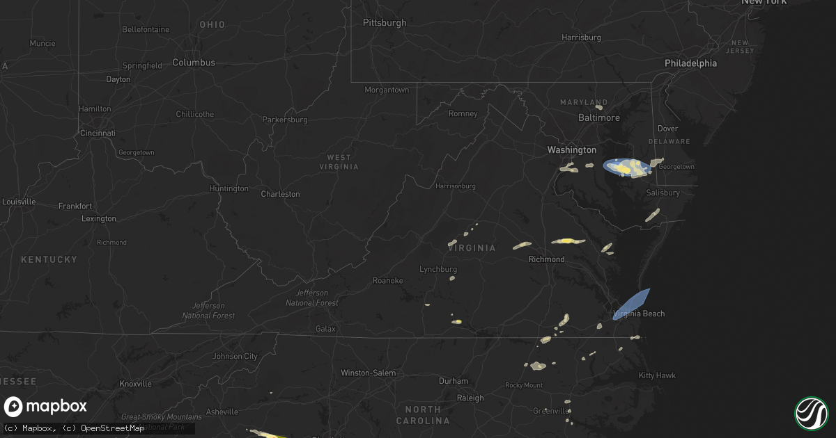
Hail Map in Virginia on July 3, 2023
Get this storm
July 3 map
$229
one time, instant access
Download today. No call, no setup
Keep the $229
Bought the map and want the full workflow? Apply the entire $229 to a subscription within 7 days. None of it is wasted.
Every map, not just this one
This buys you this map. Subscription and you get every map we run, in the markets you choose from a few cities to whole states to nationwide. Plus real-time alerts the moment a storm fires.
Contact data
Name, contact info, occupancy, even credit band for addresses in the footprint. You go from where it hit to who to call.
Become the source they trust
Unlimited branding weather history reports on demand. You already have the documented answer ready for the property owner, and you are the one who showed up with it.
Property data and RoofTrace estimates
Pull up any address you have got, its value and the exact code rules for that jurisdiction, straight from One Click Code. Then RoofTrace estimates the squares, pitch, and roof value, priced the way you price.
Storm reports in Virginia
Virginia
| Date | Description |
|---|---|
| 07/03/20236:47 PM CDT | Thunderstorm winds blew down one tree near the intersection of lowesville road and u.s. 60. |
| 07/03/20236:17 PM CDT | Thunderstorm winds blew down a tree near the intersection of elon road and the blue ridge parkway. |
| 07/03/20235:22 PM CDT | 911 call center reported a tree down on lancaster creek drive. Time estimated from radar. |
| 07/03/20235:02 PM CDT | Emergency manager reported structural/roof damage to 6 homes along little florida rd... Including a buckled roof that allowed water to enter the home. |
| 07/03/20234:27 PM CDT | One tree down due to thunderstorm winds along the 10500 block of belmont boulevard. |
| 07/03/20234:27 PM CDT | One tree down due to thunderstorm winds along the 10500 block of blemont boulevard. |
| 07/03/20234:27 PM CDT | One tree down due to thunderstorm winds along the 7600 block of wiley drive/ |
| 07/03/20234:25 PM CDT | A few hailstones as large as a quarter reported at a business on u.s. Highway 360. |
| 07/03/20234:18 PM CDT | 911 call center reported a tree down on irvington road. Time estimated from radar. |
| 07/03/20233:46 PM CDT | Lafayette river tower reported a wind gust of 54kt. |
| 07/03/20233:44 PM CDT | Tree downed on mountain road and rosmarin road. Time estimated from radar. |
| 07/03/20233:40 PM CDT | Trees downed along sandy hook rd. Va-522 near poorhouse road. |
| 07/03/20233:40 PM CDT | Report from mping: 1-inch tree limbs broken; shingles blown off. |
| 07/03/20233:12 PM CDT | Tree downed on river road west. |
| 07/03/20232:50 PM CDT | Multiple trees down due to thunderstorm winds near the intersection of stony point road and turkey sag road. |
| 07/03/20232:28 PM CDT | Tree down across va-35 near farmers bridges rd. Time estimated from radar. |
| 07/03/20232:25 PM CDT | Tree down across route 651 in the vicinity of popes station road. |
| 07/03/20232:15 PM CDT | Tree down at benefit road and blacksmith trail. Time estimated by radar. |
| 07/03/20232:08 PM CDT | Multiple trees down due to thunderstorm winds along patrick henry highway. |
| 07/03/20231:47 PM CDT | Several very large branches blown down by thunderstorm winds on piney grove road. Pea size hail was also observed. |
| 07/02/20238:36 PM CDT | Tree down along us-460 west of prospect. |
| 07/02/20238:34 PM CDT | Tree down on douglas church road. |
| 07/02/20238:24 PM CDT | Two trees blown down by thunderstorm winds near ca ira road. |
| 07/02/20238:24 PM CDT | Thunderstorm winds blew a tree onto the road near the intersection of old evergreen road and old bethany road. |
| 07/02/20238:21 PM CDT | Several trees down due to thunderstorm winds along stony point road. |
| 07/02/20238:21 PM CDT | Thunderstorm winds blew a tree down on rocks church road. |
| 07/02/20238:15 PM CDT | Thunderstorm winds blew a tree down on the road near the intersection of purdum mill road and country club lane. |
| 07/02/20238:07 PM CDT | Thunderstorm winds blew a tree down on the road near police tower road. |
| 07/02/20238:06 PM CDT | Thunderstorms winds blew a tree onto a power line near elliott lane. |
| 07/02/20238:00 PM CDT | Several trees down due to thunderstorm winds in the north garden area. |
| 07/02/20237:41 PM CDT | Thunderstorm winds blew down one tree near west james anderson highway near the appomattox county line. |
| 07/02/20237:38 PM CDT | One tree down due to thunderstorm winds along the 3000 block of river road. |
| 07/02/20237:38 PM CDT | Multiple trees down on old ridge road near woods mill. Trees also down near ridgecrest baptist church on us-29. |
| 07/02/20237:37 PM CDT | Thunderstorm winds blew a tree onto a powerline near the intersection of reedy spring road and richmond highway. |
| 07/02/20237:30 PM CDT | Thunderstorm winds blew down one tree at the intersection of dean johns place and oakville road. |
| 07/02/20237:30 PM CDT | Corrects previous tstm wnd dmg report from 2 sse oakville. Thunderstorm winds blew down at least two trees near the intersection of dean johns place and oakville road. |
| 07/02/20237:24 PM CDT | Multiple trees blew down on us-29 and adjoining roads near lovingston. |
| 07/02/20237:04 PM CDT | A few trees were downed by thunderstorm winds near the intersection of patrick henry highway and canodys store road. |
All States Impacted by Hail Map on July 3, 2023
Cities Impacted by Hail Map on July 3, 2023
- Shipman, VA
- Wingina, VA
- Schuyler, VA
- Esmont, VA
- Howardsville, VA
- Lodge Grass, MT
- Wakita, OK
- Perry, OK
- Waukomis, OK
- Bison, OK
- Town Creek, AL
- Burlington, OK
- Red Rock, OK
- Stillwater, OK
- Fowler, IN
- Ames, OK
- Enid, OK
- Amorita, OK
- Boswell, IN
- Brookston, IN
- Wolcott, IN
- Chalmers, IN
- Earl Park, IN
- Forest City, NC
- Ellenboro, NC
- Mooresboro, NC
- Shelby, NC
- Grover, NC
- Gaffney, SC
- Blacksburg, SC
- Yankton, SD
- Lesterville, SD
- Utica, SD
- Stony Point, NY
- Fort Montgomery, NY
- Cortlandt Manor, NY
- Garrison, NY
- Bear Mountain, NY
- Tomkins Cove, NY
- Yorktown Heights, NY
- Shrub Oak, NY
- Mohegan Lake, NY
- Peekskill, NY
- Lake Peekskill, NY
- Crompond, NY
- Buchanan, NY
- Montrose, NY
- Verplanck, NY
- Putnam Valley, NY
- Jefferson Valley, NY
- Chesapeake, VA
- Portsmouth, VA
- Norfolk, VA
- Virginia Beach, VA
- Piedmont, SD
- Sturgis, SD
- Aylett, VA
- Walkerton, VA
- King William, VA
- Woodbine, GA
- Star Prairie, WI
- New Richmond, WI
- Deer Park, WI
- Hawarden, IA
- Alcester, SD
- Elk Point, SD
- Somers, NY
- Katonah, NY
- Mahopac, NY
- Amawalk, NY
- Granite Springs, NY
- Bruington, VA
- Saint Stephens Church, VA
- Black Hawk, SD
- Rapid City, SD
- Chatsworth, IA
- Akron, IA
- Aurelia, IA
- Alta, IA
- Lead, SD
- Grand View, WI
- Cable, WI
- Hayward, WI
- Mason, WI
- Drummond, WI
- Marengo, WI
- High Bridge, WI
- Clam Lake, WI
- Upson, WI
- Mellen, WI
- Iron Belt, WI
- Glidden, WI
- Butternut, WI
- Solon Springs, WI
- Linn Grove, IA
- Cherokee, IA
- Deadwood, SD
- Oxford, MD
- Cambridge, MD
- Trappe, MD
- Rush Valley, UT
- Dugway, UT
- Stockton, UT
- Tooele, UT
- Vernon, UT
- Lander, WY
- Arapahoe, WY
- Riverton, WY
- Fort Washakie, WY
- Kinnear, WY
- Pavillion, WY
- Hudson, WY
- Shoshoni, WY
- Jeffrey City, WY
- Lysite, WY
- Hermosa, SD
- Rembrandt, IA
- Storm Lake, IA
- North Beach, MD
- Saint Michaels, MD
- Royal Oak, MD
- Easton, MD
- Tilghman, MD
- Bozman, MD
- Sherwood, MD
- Neavitt, MD
- Wittman, MD
- Preston, MD
- Hurlock, MD
- East New Market, MD
- Secretary, MD
- Owings, MD
- Chesapeake Beach, MD
- Mercer, WI
- Park Falls, WI
- Winter, WI
- Hurley, WI
- Phillips, WI
- Fifield, WI
- Cedar Valley, UT
- Eureka, UT
- Orem, UT
- Santaquin, UT
- Spanish Fork, UT
- Goshen, UT
- Payson, UT
- Provo, UT
- Mapleton, UT
- Mona, UT
- Springville, UT
- Salem, UT
- Hill City, SD
- Port Wing, WI
- Houston, MS
- Scotland, SD
- Ashland, WI
- Iron River, WI
- Sheridan, AR
- Maple, WI
- Brule, WI
- Luck, WI
- Cushing, WI
- Frederic, WI
- Soda Springs, ID
- Yates Center, KS
- Cleveland, MS
- Moulton, AL
- Waskom, TX
- Eagle Butte, SD
- Williamston, NC
- Washington, NC
- Hammond, WI
- Baldwin, WI
- Homer, LA
- Gordon, WI
- Beresford, SD
- Shannon, MS
- Story, AR
- Emerson, AR
- Magnolia, AR
- Somerset, WI
- Ada, OK
- Stonewall, OK
- Cumberland, WI
- Martin, SD
- Courtland, VA
- Siren, WI
- Danbury, WI
- Webster, WI
- Nemo, SD
- Truman, MN
- Trimont, MN
- Welcome, MN
- Fairmont, MN
- Scott, AR
- England, AR
- Houlton, WI
- Hudson, WI
- Avon, SD
- Dante, SD
- Suffolk, VA
- Drumright, OK
- Jennings, OK
- Mannford, OK
- Mescalero, NM
- Centerville, SD
- Wakonda, SD
- Cove, AR
- Volin, SD
- Inman, SC
- Campobello, SC
- Pleasant Hill, NC
- Emporia, VA
- Margarettsville, NC
- Seaboard, NC
- Clarksville, TX
- Bagwell, TX
- Marshall, OK
- Union Grove, AL
- Arab, AL
- Hobbsville, NC
- Gatesville, NC
- Laceys Spring, AL
- Somerville, AL
- Valhermoso Springs, AL
- Nash, OK
- Jacksonville, FL
- Amery, WI
- Osceola, WI
- Dresser, WI
- Double Springs, AL
- Sulligent, AL
- Vernon, AL
- Roberts, WI
- Vivian, LA
- Jefferson, TX
- Minong, WI
- Rodessa, LA
- Collierville, TN
- Red Banks, MS
- Holly Springs, MS
- Byhalia, MS
- Pound Ridge, NY
- Bedford, NY
- Atwood, OK
- Longview, TX
- Harrellsville, NC
- Cofield, NC
- Hennepin, OK
- Ratliff City, OK
- Waldorf, MD
- Bryans Road, MD
- Alexandria, VA
- Lorton, VA
- Fort Belvoir, VA
- Fort Washington, MD
- Accokeek, MD
- Sunflower, MS
- Schlater, MS
- Tucker, AR
- Crescent, OK
- Bristow, OK
- Trinity, AL
- Smithville, OK
- Aberdeen, MS
- Okolona, MS
- Bernice, LA
- Mccurtain, OK
- Stigler, OK
- Collinsville, AL
- Wickes, AR
- Capron, VA
- Okemah, OK
- Greenville, NC
- Paden, OK
- Boley, OK
- Addison, AL
- Ranburne, AL
- Heflin, AL
- Bowdon, GA
- Hot Springs National Park, AR
- Fairmont, OK
- Douglas, OK
- McCaskill, AR
- Roff, OK
- Tatum, NM
- Eudora, AR
- Dermott, AR
- Scotland Neck, NC
- Enfield, NC
- Pontotoc, MS
- Gunnison, MS
- Courtland, MS
- Little Rock, AR
- Castle, OK
- Superior, WI
- Marietta, MS
- Fulton, MS
- Mantachie, MS
- Two Harbors, MN
- Stuart, OK
- Mcalester, OK
- Fulton, AR
- Morganton, NC
- Guntersville, AL
- Ireton, IA
- Farmerville, LA
- Central Valley, NY
- Bedford Hills, NY
- Harriman, NY
- Monroe, NY
- Southfields, NY
- Whiteville, NC
- Kingfisher, OK
- Mulhall, OK
- Crossville, AL
- Boaz, AL
- New Hope, AL
- Huntsville, AL
- Owens Cross Roads, AL
- Red Bay, AL
- Leesburg, AL
- Knotts Island, NC
- Umpire, AR
- Glen, MS
- Booneville, MS
- Burnsville, MS
- Rienzi, MS
- Mangham, LA
- Graham, OK
- Healdton, OK
- Clinton, NC
- Tabor City, NC
- Maidens, VA
- Rockville, VA
- Oilville, VA
- Itta Bena, MS
- Greenwood, LA
- Crozier, VA
- Goochland, VA
- Manakin Sabot, VA
- Powhatan, VA
- Mer Rouge, LA
- Atlanta, TX
- Baileyton, AL
- Eva, AL
- Sims, AR
- Mount Ida, AR
- Gregory, SD
- Dallas, SD
- Halifax, NC
- Blossom, TX
- Detroit, TX
- Roland, AR
- Bruce, MS
- Houlka, MS
- Randolph, MS
- Arthur City, TX
- Irene, SD
- Springville, PA
- Meshoppen, PA
- Spearsville, LA
- Junction City, AR
- Lillie, LA
- Ely, MN
- Waverly, GA
- Mounds, OK
- Beggs, OK
- Danville, AR
- Belleville, AR
- Shreveport, LA
- Altus, OK
- Hillsboro, AL
- Courtland, AL
- Darien, GA
- Townsend, GA
- Walters, OK
- Haynesville, LA
- Avinger, TX
- Silver Bay, MN
- Houston, AR
- Perryville, AR
- Ashland, VA
- Cushing, OK
- Yale, OK
- Moorhead, MS
- Henryetta, OK
- Okmulgee, OK
- Amboy, MN
- Chocowinity, NC
- Brunswick, GA
- Belcher, LA
- Mooringsport, LA
- Guthrie, OK
- Edmond, OK
- Blackshear, GA
- Patterson, GA
- Holdenville, OK
- Calvin, OK
- Diana, TX
- Centuria, WI
- Balsam Lake, WI
- Saint Croix Falls, WI
- Laceyville, PA
- Montrose, PA
- El Reno, OK
- Hinton, OK
- Comstock, WI
- Lovington, NM
- Brimson, MN
- Nettleton, MS
- Amory, MS
- Depew, OK
- South Boston, VA
- Halifax, VA
- Victor, ID
- Driggs, ID
- Lava Hot Springs, ID
- Bigelow, AR
- Keo, AR
- Seminole, OK
- Prague, OK
- Olive Branch, MS
- Omega, OK
- Rutherfordton, NC
- Belmont, MS
- Golden, MS
- New Site, MS
- Dennis, MS
- Mission Hill, SD
- Drewryville, VA
- Boykins, VA
- Croton On Hudson, NY
- Sherburn, MN
- Dunnell, MN
- Flomot, TX
- Grapevine, AR
- Rohwer, AR
- Hot Springs Village, AR
- Jessieville, AR
- Mound Bayou, MS
- Rayville, LA
- Rossville, TN
- Oak Ridge, LA
- Hawkinsville, GA
- Tishomingo, MS
- Redfield, AR
- Washington, AR
- Spruce Pine, AL
- Russellville, AL
- Greenwood, MS
- Corinth, MS
- Marshall, TX
- Watson, OK
- South Mills, NC
- Macon, GA
- Orlando, OK
- Mena, AR
- Hallsville, TX
- Sterling, KS
- Oxford, MS
- Albertville, AL
- Hennessey, OK
- Webbers Falls, OK
- Porum, OK
- Malvern, AR
- Drew, MS
- Ruleville, MS
- Merigold, MS
- Duluth, MN
- Culloden, GA
- Yatesville, GA
- Paris, TX
- Spindale, NC
- Kings Mountain, NC
- Mill Spring, NC
- Gilmer, TX
- Ore City, TX
- Hartselle, AL
- Clarkton, NC
- Hatfield, AR
- South Salem, NY
- Gretna, VA
- Lake Waccamaw, NC
- Council, NC
- Mccammon, ID
- Canton, MS
- Folkston, GA
- Anadarko, OK
- Fort Cobb, OK
- Pawnee, OK
- Arcadia, OK
- Pomeroy, IA
- Manson, IA
- Rockwell City, IA
- Jolley, IA
- Salt Lake City, UT
- West Valley City, UT
- Bingham Canyon, UT
- Bountiful, UT
- Magna, UT
- North Salt Lake, UT
- Grantsville, UT
- West Jordan, UT
- Vineyard, UT
- Wallsburg, UT
- American Fork, UT
- Pleasant Grove, UT
- Lindon, UT
- Midway, UT
- Heber City, UT
- Oakley, UT
- Kamas, UT
- Mountain Home, UT
- Fruitland, UT
- Hanna, UT
- Tabiona, UT
- Roosevelt, UT
- Talmage, UT
- Park City, UT
- Coalville, UT
- Peoa, UT
- Saratoga Springs, UT
- Sandy, UT
- Alpine, UT
- Federalsburg, MD
- Wheatland, WY
- Hastings, MN
- Fairburn, SD
- Pine Ridge, SD
- Custer, SD
- Keystone, SD
- Evansville, WY
- Casper, WY
- Mills, WY
- Natrona, WY
- Douglas, WY
- Glenrock, WY
- Glendo, WY
- Shawnee, WY
- Lakeville, MN
- Rosemount, MN
- Farmington, MN
- Saint Paul, MN
- Dundas, MN
- Northfield, MN
- Lingle, WY
- Torrington, WY
- Veteran, WY
- Morrill, NE
- Lance Creek, WY
- Lost Springs, WY
- Manville, WY
- Lusk, WY
- Harrison, NE
- Van Tassell, WY
- Gillette, WY
- Rozet, WY
- Moorcroft, WY
- Imperial, TX
- Upton, WY
- Edgemont, SD
- Newcastle, WY
- Smithwick, SD
- Oelrichs, SD
- Whitney, NE
- Oral, SD
- Crawford, NE
- Chadron, NE
- Tolstoy, SD
- Onaka, SD
- Seneca, SD
- Florence, SD
- Henry, SD
- Oglala, SD
- Rushville, NE
- Hay Springs, NE
- Garretson, SD
- Little Elm, TX
- Bruce, WI
- Menomonie, WI
- Stillwater, MN
- Glen Flora, WI
- Tony, WI
- Gilman, WI
- Livingston, MT
- Washburn, WI
- Hooper, UT
- Ladysmith, WI
- Caddo Gap, AR
- Glenwood, AR
- Sheldon, WI
- Hobbs, NM
- Sundance, WY
- Devils Tower, WY
- Belle Fourche, SD
- Evanston, WY
- Eau Galle, WI
- Elmwood, WI
- Gettysburg, SD
- Springer, OK
- Matador, TX
- Mckinney, TX
- Afton, MN
- River Falls, WI
- White Hall, AR
- Wilson, OK
- Orient, SD
- Seminole, TX
- Cornell, WI
- Honey Grove, TX
- Kennan, WI
- Hawkins, WI
- Commerce, TX
- Campbell, TX
- Wallace, SD
- Fort Stockton, TX
- Garysburg, NC
- Conrath, WI
- Holcombe, WI
- Murdo, SD
- Turtle Lake, WI
- North Garden, VA
- Faber, VA
- Lovingston, VA
- Piney River, VA
- Arrington, VA
- Roseland, VA
- Draper, SD
- Seaford, DE
- Bridgeville, DE
- Collinsville, TX
- Howe, TX
- Marine On Saint Croix, MN
- Scandia, MN
- Cottage Grove, MN
- Tyndall, SD
- Tabor, SD
- Clare, IA
- Frisco, TX
- Prattsville, AR
- Claflin, KS
- Leola, AR
- Carthage, AR
- Lancaster, VA
- Weems, VA
- Monahans, TX
- Saint Paul Park, MN
- Spring Valley, WI
- Woodville, WI
- Center City, MN
- Bald Knob, AR
- Elk Mound, WI
- Mondovi, WI
- Sadler, TX
- Whitesboro, TX
- Sherman, TX
- Couderay, WI
- Lindstrom, MN
- Holstein, IA
- Quimby, IA
- Lublin, WI
- Thorp, WI
- Brookston, TX
- Sarah, MS
- Crenshaw, MS
- Sardis, MS
- Shafer, MN
- Taylors Falls, MN
- Alden, KS
- Kingsley, IA
- Correctionville, IA
- Pierson, IA
- Washta, IA
- Galva, IA
- Batesville, MS
- Peterson, IA
- Plains, TX
- Withee, WI
- Caputa, SD
- Maiden Rock, WI
- Ellsworth, WI
- Arkansaw, WI
- Plum City, WI
- Whitewright, TX
- Bonham, TX
- Trenton, TX
- Stanley, WI
- Boyd, WI
- Celina, TX
- Albert City, IA
- Palmer, IA
- Watson, AR
- Highland Mills, NY
- Cornwall, NY
- Towson, MD
- Branchville, VA
- Columbus, MS
- Como, MS
- Bayport, MN
- Scottsburg, VA
- New Canaan, CT
- Stamford, CT
- Milltown, WI
- Lakeland, MN
- Clear Lake, WI
- Wilson, WI
- Broken Bow, OK
- Telephone, TX
- Gainesville, TX
- Cannon Falls, MN
- Randolph, MN
- Lutherville Timonium, MD
- Loris, SC
- Tunica, MS
- Prosper, TX
- Sledge, MS
- Marks, MS
- Monument, NM
- Grayson, GA
- Lawrenceville, GA
- Loganville, GA
- Valley Cottage, NY
- Congers, NY
- Lake City, MN
- Donaldson, AR
- Friendship, AR
- Arkadelphia, AR
- Sheffield, TX
- Klondike, TX
- Wright, WY
- Ringling, OK
- Powderly, TX
- Roxton, TX
- Petty, TX
- Sumner, TX
- Macon, MS
- Brooksville, MS
- Nerstrand, MN
- Faribault, MN
- Elmore City, OK
- Tillar, AR
- Lonsdale, MN
- Webster, MN
- Gilmore City, IA
- Cumby, TX
- Ladonia, TX
- Greenville, TX
- Pecan Gap, TX
- Waco, GA
- Milburn, OK
- Senatobia, MS
- Chippewa Falls, WI
- Eau Claire, WI
- Westover, MD
- Gunter, TX
- Pilot Point, TX
- Lake Dallas, TX
- McCall Creek, MS
- Union Church, MS
- Brookhaven, MS
- Faulkton, SD
- Orange City, IA
- Maurice, IA
- Hot Springs, SD
- Topping, VA
- White Stone, VA
- Goldens Bridge, NY
- Mount Kisco, NY
- King And Queen Court House, VA
- Muscadine, AL
- Valley View, TX
- Inver Grove Heights, MN
- Many, LA
- Palatka, FL
- Manquin, VA
- Long Valley, SD
- Wanblee, SD
- Valliant, OK
- Dundee, MS
- Vermillion, MN
- Spout Spring, VA
- Concord, VA
- Denver City, TX
- Wilsonville, AL
- Columbiana, AL
- Olustee, OK
- Elmer, OK
- Rich Square, NC
- Hanover, VA
- Center Cross, VA
- West Point, MS
- Minco, OK
- Fitzhugh, OK
- Rosston, TX
- Era, TX
- Forestburg, TX
- Beldenville, WI
- Aubrey, TX
- Savoy, TX
- Wilton, CT
- Ridgefield, CT
- Marion Station, MD
- Princess Anne, MD
- Waltham, MN
- Hugo, OK
- Prescott, WI
- Ector, TX
- Schaller, IA
- Wall, SD
- Scenic, SD
- Interior, SD
- Quinn, SD
- Owanka, SD
- New Underwood, SD
- Kadoka, SD
- Kyle, SD
- Wasta, SD
- Philip, SD
- Vermillion, SD
- Burbank, SD
- Belvidere, SD
- Okaton, SD
- White River, SD
- Midland, SD
- Selby, SD
- Bowdle, SD
- Java, SD
- Hosmer, SD
- Bradley, SD
- Wood, SD
- Hoven, SD
- Redfield, SD
- Huron, SD
- Winner, SD
- Pierre, SD
- Fort Pierre, SD
- Raymond, SD
- Houston, MN
- Randolph, TX
- Turton, SD
- Charlottesville, VA
- Millville, MN
- Alma, WI
- Nelson, WI
- Frankfort, SD
- Doland, SD
- Rhodesdale, MD
- Blunt, SD
- Mechanicsville, VA
- Garden City, SD
- Greenwood, DE
- Kellogg, MN
- Wabasha, MN
- White Plains, MD
- Mission, SD
- Presho, SD
- Lake Preston, SD
- Bivins, TX
- Independence, WI
- Woonsocket, SD
- Dubach, LA
- Wykoff, MN
- Preston, MN
- Spring Valley, MN
- Upper Marlboro, MD
- Brandywine, MD
- Rehoboth Beach, DE
- Lewes, DE
- Bryant, SD
- Yale, SD
- Willow Lake, SD
- Carpenter, SD
- Iroquois, SD
- De Smet, SD
- Le Roy, MN
- Ashton, SD
- Millsboro, DE
- Harbeson, DE
- Mount Holly, AR
- El Dorado, AR
- Altura, MN
- Erwin, SD
- Rollingstone, MN
- Colome, SD
- Moville, IA
- Durand, WI
- Parkville, MD
- Baltimore, MD
- Oil City, LA
- Trempealeau, WI
- Galesville, WI
- Vivian, SD
- Dell Rapids, SD
- Fountain City, WI
- Arcadia, WI
- Saluda, VA
- Manly, IA
- Mason City, IA
- Stoddard, WI
- Clark, SD
- Witten, SD
- La Crescent, MN
- Hokah, MN
- Brownsville, MN
- Tioga, TX
- Plainview, MN
- Crisfield, MD
- Dakota, MN
- Winona, MN
- Pukwana, SD
- Fort Thompson, SD
- Wessington Springs, SD
- Gann Valley, SD
- Kimball, SD
- Reliance, SD
- Chamberlain, SD
- Oacoma, SD
- Artesian, SD
- Platte, SD
- Letcher, SD
- Lawler, IA
- White Lake, SD
- Mount Vernon, SD
- Stickney, SD
- Kennebec, SD
- Belmont, LA
- Carmel, NY
- Mitchell, SD
- Plankinton, SD
- Valentine, NE
- Burke, SD
- New Hampton, IA
- Fredericksburg, IA
- Trail City, SD
- Roscoe, SD
- Waverly, IA
- Shell Rock, IA
- Ethan, SD
- Fort Dodge, IA
- Janesville, IA
- Sacred Heart, MN
- The Colony, TX


