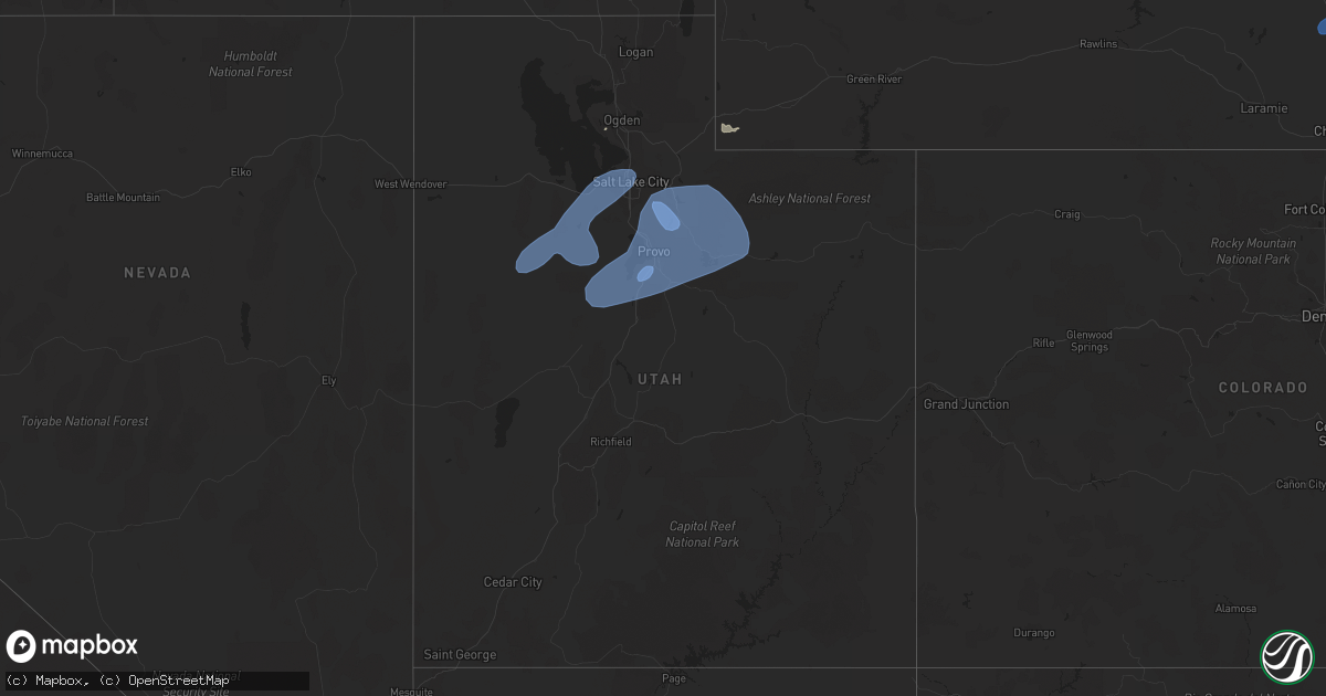
Hail Map in Utah on July 3, 2023
Get this storm
July 3 map
$229
one time, instant access
Download today. No call, no setup
Keep the $229
Bought the map and want the full workflow? Apply the entire $229 to a subscription within 7 days. None of it is wasted.
Every map, not just this one
This buys you this map. Subscription and you get every map we run, in the markets you choose from a few cities to whole states to nationwide. Plus real-time alerts the moment a storm fires.
Contact data
Name, contact info, occupancy, even credit band for addresses in the footprint. You go from where it hit to who to call.
Become the source they trust
Unlimited branding weather history reports on demand. You already have the documented answer ready for the property owner, and you are the one who showed up with it.
Property data and RoofTrace estimates
Pull up any address you have got, its value and the exact code rules for that jurisdiction, straight from One Click Code. Then RoofTrace estimates the squares, pitch, and roof value, priced the way you price.
Storm reports in Utah
Utah
| Date | Description |
|---|---|
| 07/03/20236:50 PM CDT | Mesonet station utdcd 3.3 ne sundance |
| 07/03/20236:45 PM CDT | Tree down in santaquin. |
| 07/03/20236:45 PM CDT | Large light pole down. |
| 07/03/20236:45 PM CDT | Roof blown off manufactured home. |
| 07/03/20236:45 PM CDT | Tree snapped near base. |
| 07/03/20236:40 PM CDT | 3 to 4 inch tree limbs broken. |
| 07/03/20236:34 PM CDT | Asos station kslc salt lake city intl arpt station elevation: 4225 ft. |
| 07/03/20236:34 PM CDT | Faa wind sensor. |
| 07/03/20236:30 PM CDT | Mesonet station utprb sr-131 at mp 0.5 porter rockwell station elevation: 4516 ft. |
| 07/03/20236:30 PM CDT | Mesonet station utbrc 2.8 n payson |
| 07/03/20236:30 PM CDT | Powerlines down. |
| 07/03/20236:30 PM CDT | Report from mping: 1-inch tree limbs broken; shingles blown off. |
| 07/03/20236:30 PM CDT | Mesonet station utalp 2.9 se bluffdale |
| 07/03/20236:24 PM CDT | Power poles down... Multiple trees uprooted. |
| 07/03/20236:20 PM CDT | Mesonet station utlak 7.6 se fairfield |
| 07/03/20236:20 PM CDT | Mesonet station fg024 1.8 nw santaquin |
| 07/03/20236:20 PM CDT | Mesonet station ut201 sr-201 at i-80 station elevation: 4271 ft. |
| 07/03/20236:20 PM CDT | Mesonet station ut107 i-80 at mp 107 station elevation: 4225 ft. |
| 07/03/20236:20 PM CDT | Mesonet station utbrc 2.8 n payson |
| 07/03/20236:20 PM CDT | Mesonet station fg009 0.9 n santaquin |
| 07/03/20236:15 PM CDT | Mesonet station kcc02 5.6 ne lake pt |
| 07/03/20236:15 PM CDT | Large tree down including a large root ball. |
| 07/03/20236:10 PM CDT | Many large branches and trees down in genola. |
| 07/03/20236:00 PM CDT | Mesonet station utedl 1.5 se delle |
| 07/03/20235:58 PM CDT | Mesonet station arau1 aragonite station elevation: 5029 ft. |
| 07/03/20235:50 PM CDT | Mesonet station pc195 eureka ridge station elevation: 7872 ft. |
| 07/03/20235:45 PM CDT | Mesonet station up106 5.4 se clover |
| 07/03/20235:40 PM CDT | Mesonet station pc348 tintic station elevation: 6575 ft. |
| 07/03/20235:40 PM CDT | Mesonet station utjps 5.4 w clover |
| 07/03/20235:20 PM CDT | Mesonet station dpg07 english village |
| 07/03/20235:10 PM CDT | Mesonet station dpg06 14.0 sw dugway |
| 07/02/20237:30 PM CDT | Mesonet station utkno i-80 at mp 40 knolls station elevation: 4243 ft. |
| 07/02/20237:20 PM CDT | Mesonet station ut33 11.5 w knolls |
| 07/02/20237:20 PM CDT | Mesonet station pc298 the head station elevation: 8539 ft. |
| 07/02/20237:20 PM CDT | Mesonet station pc063 brown's canyon station elevation: 6623 ft. |
| 07/02/20237:06 PM CDT | Power lines down in morgan. |
| 07/02/20237:06 PM CDT | Large... Healthy tree snapped near the base at heber city police station. |
| 07/02/20237:06 PM CDT | Trees reported down in midway. |
| 07/02/20237:05 PM CDT | 6 inch limbs snapped off trees. |
| 07/02/20237:04 PM CDT | Report from mping: 1-inch tree limbs broken; shingles blown off. |
| 07/02/20237:00 PM CDT | Mesonet station mby 3.3 s park city |
| 07/02/20237:00 PM CDT | Mesonet station hdp 0.7 se snowbird |
| 07/02/20237:00 PM CDT | Tree snapped at base. |
| 07/02/20237:00 PM CDT | Mesonet station iff 1.7 n snowbird |
All States Impacted by Hail Map on July 3, 2023
Cities Impacted by Hail Map on July 3, 2023
- Shipman, VA
- Wingina, VA
- Schuyler, VA
- Esmont, VA
- Howardsville, VA
- Lodge Grass, MT
- Wakita, OK
- Perry, OK
- Waukomis, OK
- Bison, OK
- Town Creek, AL
- Burlington, OK
- Red Rock, OK
- Stillwater, OK
- Fowler, IN
- Ames, OK
- Enid, OK
- Amorita, OK
- Boswell, IN
- Brookston, IN
- Wolcott, IN
- Chalmers, IN
- Earl Park, IN
- Forest City, NC
- Ellenboro, NC
- Mooresboro, NC
- Shelby, NC
- Grover, NC
- Gaffney, SC
- Blacksburg, SC
- Yankton, SD
- Lesterville, SD
- Utica, SD
- Stony Point, NY
- Fort Montgomery, NY
- Cortlandt Manor, NY
- Garrison, NY
- Bear Mountain, NY
- Tomkins Cove, NY
- Yorktown Heights, NY
- Shrub Oak, NY
- Mohegan Lake, NY
- Peekskill, NY
- Lake Peekskill, NY
- Crompond, NY
- Buchanan, NY
- Montrose, NY
- Verplanck, NY
- Putnam Valley, NY
- Jefferson Valley, NY
- Chesapeake, VA
- Portsmouth, VA
- Norfolk, VA
- Virginia Beach, VA
- Piedmont, SD
- Sturgis, SD
- Aylett, VA
- Walkerton, VA
- King William, VA
- Woodbine, GA
- Star Prairie, WI
- New Richmond, WI
- Deer Park, WI
- Hawarden, IA
- Alcester, SD
- Elk Point, SD
- Somers, NY
- Katonah, NY
- Mahopac, NY
- Amawalk, NY
- Granite Springs, NY
- Bruington, VA
- Saint Stephens Church, VA
- Black Hawk, SD
- Rapid City, SD
- Chatsworth, IA
- Akron, IA
- Aurelia, IA
- Alta, IA
- Lead, SD
- Grand View, WI
- Cable, WI
- Hayward, WI
- Mason, WI
- Drummond, WI
- Marengo, WI
- High Bridge, WI
- Clam Lake, WI
- Upson, WI
- Mellen, WI
- Iron Belt, WI
- Glidden, WI
- Butternut, WI
- Solon Springs, WI
- Linn Grove, IA
- Cherokee, IA
- Deadwood, SD
- Oxford, MD
- Cambridge, MD
- Trappe, MD
- Rush Valley, UT
- Dugway, UT
- Stockton, UT
- Tooele, UT
- Vernon, UT
- Lander, WY
- Arapahoe, WY
- Riverton, WY
- Fort Washakie, WY
- Kinnear, WY
- Pavillion, WY
- Hudson, WY
- Shoshoni, WY
- Jeffrey City, WY
- Lysite, WY
- Hermosa, SD
- Rembrandt, IA
- Storm Lake, IA
- North Beach, MD
- Saint Michaels, MD
- Royal Oak, MD
- Easton, MD
- Tilghman, MD
- Bozman, MD
- Sherwood, MD
- Neavitt, MD
- Wittman, MD
- Preston, MD
- Hurlock, MD
- East New Market, MD
- Secretary, MD
- Owings, MD
- Chesapeake Beach, MD
- Mercer, WI
- Park Falls, WI
- Winter, WI
- Hurley, WI
- Phillips, WI
- Fifield, WI
- Cedar Valley, UT
- Eureka, UT
- Orem, UT
- Santaquin, UT
- Spanish Fork, UT
- Goshen, UT
- Payson, UT
- Provo, UT
- Mapleton, UT
- Mona, UT
- Springville, UT
- Salem, UT
- Hill City, SD
- Port Wing, WI
- Houston, MS
- Scotland, SD
- Ashland, WI
- Iron River, WI
- Sheridan, AR
- Maple, WI
- Brule, WI
- Luck, WI
- Cushing, WI
- Frederic, WI
- Soda Springs, ID
- Yates Center, KS
- Cleveland, MS
- Moulton, AL
- Waskom, TX
- Eagle Butte, SD
- Williamston, NC
- Washington, NC
- Hammond, WI
- Baldwin, WI
- Homer, LA
- Gordon, WI
- Beresford, SD
- Shannon, MS
- Story, AR
- Emerson, AR
- Magnolia, AR
- Somerset, WI
- Ada, OK
- Stonewall, OK
- Cumberland, WI
- Martin, SD
- Courtland, VA
- Siren, WI
- Danbury, WI
- Webster, WI
- Nemo, SD
- Truman, MN
- Trimont, MN
- Welcome, MN
- Fairmont, MN
- Scott, AR
- England, AR
- Houlton, WI
- Hudson, WI
- Avon, SD
- Dante, SD
- Suffolk, VA
- Drumright, OK
- Jennings, OK
- Mannford, OK
- Mescalero, NM
- Centerville, SD
- Wakonda, SD
- Cove, AR
- Volin, SD
- Inman, SC
- Campobello, SC
- Pleasant Hill, NC
- Emporia, VA
- Margarettsville, NC
- Seaboard, NC
- Clarksville, TX
- Bagwell, TX
- Marshall, OK
- Union Grove, AL
- Arab, AL
- Hobbsville, NC
- Gatesville, NC
- Laceys Spring, AL
- Somerville, AL
- Valhermoso Springs, AL
- Nash, OK
- Jacksonville, FL
- Amery, WI
- Osceola, WI
- Dresser, WI
- Double Springs, AL
- Sulligent, AL
- Vernon, AL
- Roberts, WI
- Vivian, LA
- Jefferson, TX
- Minong, WI
- Rodessa, LA
- Collierville, TN
- Red Banks, MS
- Holly Springs, MS
- Byhalia, MS
- Pound Ridge, NY
- Bedford, NY
- Atwood, OK
- Longview, TX
- Harrellsville, NC
- Cofield, NC
- Hennepin, OK
- Ratliff City, OK
- Waldorf, MD
- Bryans Road, MD
- Alexandria, VA
- Lorton, VA
- Fort Belvoir, VA
- Fort Washington, MD
- Accokeek, MD
- Sunflower, MS
- Schlater, MS
- Tucker, AR
- Crescent, OK
- Bristow, OK
- Trinity, AL
- Smithville, OK
- Aberdeen, MS
- Okolona, MS
- Bernice, LA
- Mccurtain, OK
- Stigler, OK
- Collinsville, AL
- Wickes, AR
- Capron, VA
- Okemah, OK
- Greenville, NC
- Paden, OK
- Boley, OK
- Addison, AL
- Ranburne, AL
- Heflin, AL
- Bowdon, GA
- Hot Springs National Park, AR
- Fairmont, OK
- Douglas, OK
- McCaskill, AR
- Roff, OK
- Tatum, NM
- Eudora, AR
- Dermott, AR
- Scotland Neck, NC
- Enfield, NC
- Pontotoc, MS
- Gunnison, MS
- Courtland, MS
- Little Rock, AR
- Castle, OK
- Superior, WI
- Marietta, MS
- Fulton, MS
- Mantachie, MS
- Two Harbors, MN
- Stuart, OK
- Mcalester, OK
- Fulton, AR
- Morganton, NC
- Guntersville, AL
- Ireton, IA
- Farmerville, LA
- Central Valley, NY
- Bedford Hills, NY
- Harriman, NY
- Monroe, NY
- Southfields, NY
- Whiteville, NC
- Kingfisher, OK
- Mulhall, OK
- Crossville, AL
- Boaz, AL
- New Hope, AL
- Huntsville, AL
- Owens Cross Roads, AL
- Red Bay, AL
- Leesburg, AL
- Knotts Island, NC
- Umpire, AR
- Glen, MS
- Booneville, MS
- Burnsville, MS
- Rienzi, MS
- Mangham, LA
- Graham, OK
- Healdton, OK
- Clinton, NC
- Tabor City, NC
- Maidens, VA
- Rockville, VA
- Oilville, VA
- Itta Bena, MS
- Greenwood, LA
- Crozier, VA
- Goochland, VA
- Manakin Sabot, VA
- Powhatan, VA
- Mer Rouge, LA
- Atlanta, TX
- Baileyton, AL
- Eva, AL
- Sims, AR
- Mount Ida, AR
- Gregory, SD
- Dallas, SD
- Halifax, NC
- Blossom, TX
- Detroit, TX
- Roland, AR
- Bruce, MS
- Houlka, MS
- Randolph, MS
- Arthur City, TX
- Irene, SD
- Springville, PA
- Meshoppen, PA
- Spearsville, LA
- Junction City, AR
- Lillie, LA
- Ely, MN
- Waverly, GA
- Mounds, OK
- Beggs, OK
- Danville, AR
- Belleville, AR
- Shreveport, LA
- Altus, OK
- Hillsboro, AL
- Courtland, AL
- Darien, GA
- Townsend, GA
- Walters, OK
- Haynesville, LA
- Avinger, TX
- Silver Bay, MN
- Houston, AR
- Perryville, AR
- Ashland, VA
- Cushing, OK
- Yale, OK
- Moorhead, MS
- Henryetta, OK
- Okmulgee, OK
- Amboy, MN
- Chocowinity, NC
- Brunswick, GA
- Belcher, LA
- Mooringsport, LA
- Guthrie, OK
- Edmond, OK
- Blackshear, GA
- Patterson, GA
- Holdenville, OK
- Calvin, OK
- Diana, TX
- Centuria, WI
- Balsam Lake, WI
- Saint Croix Falls, WI
- Laceyville, PA
- Montrose, PA
- El Reno, OK
- Hinton, OK
- Comstock, WI
- Lovington, NM
- Brimson, MN
- Nettleton, MS
- Amory, MS
- Depew, OK
- South Boston, VA
- Halifax, VA
- Victor, ID
- Driggs, ID
- Lava Hot Springs, ID
- Bigelow, AR
- Keo, AR
- Seminole, OK
- Prague, OK
- Olive Branch, MS
- Omega, OK
- Rutherfordton, NC
- Belmont, MS
- Golden, MS
- New Site, MS
- Dennis, MS
- Mission Hill, SD
- Drewryville, VA
- Boykins, VA
- Croton On Hudson, NY
- Sherburn, MN
- Dunnell, MN
- Flomot, TX
- Grapevine, AR
- Rohwer, AR
- Hot Springs Village, AR
- Jessieville, AR
- Mound Bayou, MS
- Rayville, LA
- Rossville, TN
- Oak Ridge, LA
- Hawkinsville, GA
- Tishomingo, MS
- Redfield, AR
- Washington, AR
- Spruce Pine, AL
- Russellville, AL
- Greenwood, MS
- Corinth, MS
- Marshall, TX
- Watson, OK
- South Mills, NC
- Macon, GA
- Orlando, OK
- Mena, AR
- Hallsville, TX
- Sterling, KS
- Oxford, MS
- Albertville, AL
- Hennessey, OK
- Webbers Falls, OK
- Porum, OK
- Malvern, AR
- Drew, MS
- Ruleville, MS
- Merigold, MS
- Duluth, MN
- Culloden, GA
- Yatesville, GA
- Paris, TX
- Spindale, NC
- Kings Mountain, NC
- Mill Spring, NC
- Gilmer, TX
- Ore City, TX
- Hartselle, AL
- Clarkton, NC
- Hatfield, AR
- South Salem, NY
- Gretna, VA
- Lake Waccamaw, NC
- Council, NC
- Mccammon, ID
- Canton, MS
- Folkston, GA
- Anadarko, OK
- Fort Cobb, OK
- Pawnee, OK
- Arcadia, OK
- Pomeroy, IA
- Manson, IA
- Rockwell City, IA
- Jolley, IA
- Salt Lake City, UT
- West Valley City, UT
- Bingham Canyon, UT
- Bountiful, UT
- Magna, UT
- North Salt Lake, UT
- Grantsville, UT
- West Jordan, UT
- Vineyard, UT
- Wallsburg, UT
- American Fork, UT
- Pleasant Grove, UT
- Lindon, UT
- Midway, UT
- Heber City, UT
- Oakley, UT
- Kamas, UT
- Mountain Home, UT
- Fruitland, UT
- Hanna, UT
- Tabiona, UT
- Roosevelt, UT
- Talmage, UT
- Park City, UT
- Coalville, UT
- Peoa, UT
- Saratoga Springs, UT
- Sandy, UT
- Alpine, UT
- Federalsburg, MD
- Wheatland, WY
- Hastings, MN
- Fairburn, SD
- Pine Ridge, SD
- Custer, SD
- Keystone, SD
- Evansville, WY
- Casper, WY
- Mills, WY
- Natrona, WY
- Douglas, WY
- Glenrock, WY
- Glendo, WY
- Shawnee, WY
- Lakeville, MN
- Rosemount, MN
- Farmington, MN
- Saint Paul, MN
- Dundas, MN
- Northfield, MN
- Lingle, WY
- Torrington, WY
- Veteran, WY
- Morrill, NE
- Lance Creek, WY
- Lost Springs, WY
- Manville, WY
- Lusk, WY
- Harrison, NE
- Van Tassell, WY
- Gillette, WY
- Rozet, WY
- Moorcroft, WY
- Imperial, TX
- Upton, WY
- Edgemont, SD
- Newcastle, WY
- Smithwick, SD
- Oelrichs, SD
- Whitney, NE
- Oral, SD
- Crawford, NE
- Chadron, NE
- Tolstoy, SD
- Onaka, SD
- Seneca, SD
- Florence, SD
- Henry, SD
- Oglala, SD
- Rushville, NE
- Hay Springs, NE
- Garretson, SD
- Little Elm, TX
- Bruce, WI
- Menomonie, WI
- Stillwater, MN
- Glen Flora, WI
- Tony, WI
- Gilman, WI
- Livingston, MT
- Washburn, WI
- Hooper, UT
- Ladysmith, WI
- Caddo Gap, AR
- Glenwood, AR
- Sheldon, WI
- Hobbs, NM
- Sundance, WY
- Devils Tower, WY
- Belle Fourche, SD
- Evanston, WY
- Eau Galle, WI
- Elmwood, WI
- Gettysburg, SD
- Springer, OK
- Matador, TX
- Mckinney, TX
- Afton, MN
- River Falls, WI
- White Hall, AR
- Wilson, OK
- Orient, SD
- Seminole, TX
- Cornell, WI
- Honey Grove, TX
- Kennan, WI
- Hawkins, WI
- Commerce, TX
- Campbell, TX
- Wallace, SD
- Fort Stockton, TX
- Garysburg, NC
- Conrath, WI
- Holcombe, WI
- Murdo, SD
- Turtle Lake, WI
- North Garden, VA
- Faber, VA
- Lovingston, VA
- Piney River, VA
- Arrington, VA
- Roseland, VA
- Draper, SD
- Seaford, DE
- Bridgeville, DE
- Collinsville, TX
- Howe, TX
- Marine On Saint Croix, MN
- Scandia, MN
- Cottage Grove, MN
- Tyndall, SD
- Tabor, SD
- Clare, IA
- Frisco, TX
- Prattsville, AR
- Claflin, KS
- Leola, AR
- Carthage, AR
- Lancaster, VA
- Weems, VA
- Monahans, TX
- Saint Paul Park, MN
- Spring Valley, WI
- Woodville, WI
- Center City, MN
- Bald Knob, AR
- Elk Mound, WI
- Mondovi, WI
- Sadler, TX
- Whitesboro, TX
- Sherman, TX
- Couderay, WI
- Lindstrom, MN
- Holstein, IA
- Quimby, IA
- Lublin, WI
- Thorp, WI
- Brookston, TX
- Sarah, MS
- Crenshaw, MS
- Sardis, MS
- Shafer, MN
- Taylors Falls, MN
- Alden, KS
- Kingsley, IA
- Correctionville, IA
- Pierson, IA
- Washta, IA
- Galva, IA
- Batesville, MS
- Peterson, IA
- Plains, TX
- Withee, WI
- Caputa, SD
- Maiden Rock, WI
- Ellsworth, WI
- Arkansaw, WI
- Plum City, WI
- Whitewright, TX
- Bonham, TX
- Trenton, TX
- Stanley, WI
- Boyd, WI
- Celina, TX
- Albert City, IA
- Palmer, IA
- Watson, AR
- Highland Mills, NY
- Cornwall, NY
- Towson, MD
- Branchville, VA
- Columbus, MS
- Como, MS
- Bayport, MN
- Scottsburg, VA
- New Canaan, CT
- Stamford, CT
- Milltown, WI
- Lakeland, MN
- Clear Lake, WI
- Wilson, WI
- Broken Bow, OK
- Telephone, TX
- Gainesville, TX
- Cannon Falls, MN
- Randolph, MN
- Lutherville Timonium, MD
- Loris, SC
- Tunica, MS
- Prosper, TX
- Sledge, MS
- Marks, MS
- Monument, NM
- Grayson, GA
- Lawrenceville, GA
- Loganville, GA
- Valley Cottage, NY
- Congers, NY
- Lake City, MN
- Donaldson, AR
- Friendship, AR
- Arkadelphia, AR
- Sheffield, TX
- Klondike, TX
- Wright, WY
- Ringling, OK
- Powderly, TX
- Roxton, TX
- Petty, TX
- Sumner, TX
- Macon, MS
- Brooksville, MS
- Nerstrand, MN
- Faribault, MN
- Elmore City, OK
- Tillar, AR
- Lonsdale, MN
- Webster, MN
- Gilmore City, IA
- Cumby, TX
- Ladonia, TX
- Greenville, TX
- Pecan Gap, TX
- Waco, GA
- Milburn, OK
- Senatobia, MS
- Chippewa Falls, WI
- Eau Claire, WI
- Westover, MD
- Gunter, TX
- Pilot Point, TX
- Lake Dallas, TX
- McCall Creek, MS
- Union Church, MS
- Brookhaven, MS
- Faulkton, SD
- Orange City, IA
- Maurice, IA
- Hot Springs, SD
- Topping, VA
- White Stone, VA
- Goldens Bridge, NY
- Mount Kisco, NY
- King And Queen Court House, VA
- Muscadine, AL
- Valley View, TX
- Inver Grove Heights, MN
- Many, LA
- Palatka, FL
- Manquin, VA
- Long Valley, SD
- Wanblee, SD
- Valliant, OK
- Dundee, MS
- Vermillion, MN
- Spout Spring, VA
- Concord, VA
- Denver City, TX
- Wilsonville, AL
- Columbiana, AL
- Olustee, OK
- Elmer, OK
- Rich Square, NC
- Hanover, VA
- Center Cross, VA
- West Point, MS
- Minco, OK
- Fitzhugh, OK
- Rosston, TX
- Era, TX
- Forestburg, TX
- Beldenville, WI
- Aubrey, TX
- Savoy, TX
- Wilton, CT
- Ridgefield, CT
- Marion Station, MD
- Princess Anne, MD
- Waltham, MN
- Hugo, OK
- Prescott, WI
- Ector, TX
- Schaller, IA
- Wall, SD
- Scenic, SD
- Interior, SD
- Quinn, SD
- Owanka, SD
- New Underwood, SD
- Kadoka, SD
- Kyle, SD
- Wasta, SD
- Philip, SD
- Vermillion, SD
- Burbank, SD
- Belvidere, SD
- Okaton, SD
- White River, SD
- Midland, SD
- Selby, SD
- Bowdle, SD
- Java, SD
- Hosmer, SD
- Bradley, SD
- Wood, SD
- Hoven, SD
- Redfield, SD
- Huron, SD
- Winner, SD
- Pierre, SD
- Fort Pierre, SD
- Raymond, SD
- Houston, MN
- Randolph, TX
- Turton, SD
- Charlottesville, VA
- Millville, MN
- Alma, WI
- Nelson, WI
- Frankfort, SD
- Doland, SD
- Rhodesdale, MD
- Blunt, SD
- Mechanicsville, VA
- Garden City, SD
- Greenwood, DE
- Kellogg, MN
- Wabasha, MN
- White Plains, MD
- Mission, SD
- Presho, SD
- Lake Preston, SD
- Bivins, TX
- Independence, WI
- Woonsocket, SD
- Dubach, LA
- Wykoff, MN
- Preston, MN
- Spring Valley, MN
- Upper Marlboro, MD
- Brandywine, MD
- Rehoboth Beach, DE
- Lewes, DE
- Bryant, SD
- Yale, SD
- Willow Lake, SD
- Carpenter, SD
- Iroquois, SD
- De Smet, SD
- Le Roy, MN
- Ashton, SD
- Millsboro, DE
- Harbeson, DE
- Mount Holly, AR
- El Dorado, AR
- Altura, MN
- Erwin, SD
- Rollingstone, MN
- Colome, SD
- Moville, IA
- Durand, WI
- Parkville, MD
- Baltimore, MD
- Oil City, LA
- Trempealeau, WI
- Galesville, WI
- Vivian, SD
- Dell Rapids, SD
- Fountain City, WI
- Arcadia, WI
- Saluda, VA
- Manly, IA
- Mason City, IA
- Stoddard, WI
- Clark, SD
- Witten, SD
- La Crescent, MN
- Hokah, MN
- Brownsville, MN
- Tioga, TX
- Plainview, MN
- Crisfield, MD
- Dakota, MN
- Winona, MN
- Pukwana, SD
- Fort Thompson, SD
- Wessington Springs, SD
- Gann Valley, SD
- Kimball, SD
- Reliance, SD
- Chamberlain, SD
- Oacoma, SD
- Artesian, SD
- Platte, SD
- Letcher, SD
- Lawler, IA
- White Lake, SD
- Mount Vernon, SD
- Stickney, SD
- Kennebec, SD
- Belmont, LA
- Carmel, NY
- Mitchell, SD
- Plankinton, SD
- Valentine, NE
- Burke, SD
- New Hampton, IA
- Fredericksburg, IA
- Trail City, SD
- Roscoe, SD
- Waverly, IA
- Shell Rock, IA
- Ethan, SD
- Fort Dodge, IA
- Janesville, IA
- Sacred Heart, MN
- The Colony, TX


