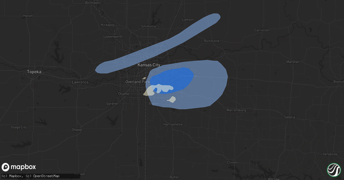
Hail Map in Lees Summit, MO on July 2, 2024
Get this storm
July 2 map
$229
one time, instant access
Download today. No call, no setup
Keep the $229
Bought the map and want the full workflow? Apply the entire $229 to a subscription within 7 days. None of it is wasted.
Every map, not just this one
This buys you this map. Subscription and you get every map we run, in the markets you choose from a few cities to whole states to nationwide. Plus real-time alerts the moment a storm fires.
Contact data
Name, contact info, occupancy, even credit band for addresses in the footprint. You go from where it hit to who to call.
Become the source they trust
Unlimited branding weather history reports on demand. You already have the documented answer ready for the property owner, and you are the one who showed up with it.
Property data and RoofTrace estimates
Pull up any address you have got, its value and the exact code rules for that jurisdiction, straight from One Click Code. Then RoofTrace estimates the squares, pitch, and roof value, priced the way you price.
Storm reports in Lees Summit, MO
Lees Summit, MO
| Date | Description |
|---|---|
| 07/01/20249:12 PM CDT | Multiple reports of trees and limbs down in the lake lotawana area. Time estimated from radar. |
| 07/01/20248:47 PM CDT | A local report indicates 89 MPH wind near 2 ENE Unity Village |
| 07/01/20248:47 PM CDT | Social media report... Photo of top of large walnut tree knocked down. |
| 07/01/20248:47 PM CDT | Downed trees near park springs terrace. Time estimated from radar. |
| 07/01/20248:45 PM CDT | Multiple reports of trees down in the lakewood area. Time estimated from radar. |
| 07/01/20248:45 PM CDT | Downed tree and wires near lees summit municipal airport. Time estimated from radar. |
All States Impacted by Hail Map on July 2, 2024
All Cities Impacted by Hail Map on July 2, 2024
- New Salem, ND
- Hazen, ND
- Beulah, ND
- Center, ND
- Stanton, ND
- Washburn, ND
- Exeter, NE
- Milligan, NE
- Friend, NE
- Geneva, NE
- Dorchester, NE
- Milford, NE
- Palmyra, NE
- Walton, NE
- Elmwood, NE
- Eagle, NE
- Bennet, NE
- Lincoln, NE
- Denton, NE
- Roca, NE
- Crete, NE
- Martell, NE
- Pleasant Dale, NE
- Malcolm, NE
- Davey, NE
- Raymond, NE
- Hogeland, MT
- Monticello, NM
- Hillsboro, NM
- Los Alamos, NM
- Benson, AZ
- Winterset, IA
- Griswold, IA
- Prole, IA
- Stanberry, MO
- Albany, MO
- Milo, IA
- Ackworth, IA
- Indianola, IA
- Knoxville, IA
- Pleasantville, IA
- Osceola, IA
- Swan, IA
- Humeston, IA
- Corydon, IA
- Saint Charles, IA
- Chariton, IA
- New Virginia, IA
- Murray, IA
- Otley, IA
- Pella, IA
- Darlington, MO
- King City, MO
- Raton, NM
- Truro, IA
- Laguna, NM
- San Simon, AZ
- Bowie, AZ
- Princeton, MO
- Mercer, MO
- Russell, IA
- Harvey, IA
- Cainsville, MO
- Sully, IA
- McFall, MO
- Martinsville, MO
- Bethany, MO
- New Hampton, MO
- Attica, KS
- Spivey, KS
- Harper, KS
- Kingman, KS
- Rea, MO
- Union Star, MO
- Ridgeway, MO
- Magdalena, NM
- Promise City, IA
- Allerton, IA
- Lineville, IA
- New Sharon, IA
- Savannah, MO
- Melrose, IA
- Montezuma, IA
- Barnes City, IA
- Deep River, IA
- Gibson, IA
- Murdock, KS
- Norwich, KS
- Milton, KS
- Cheney, KS
- Keswick, IA
- What Cheer, IA
- Webster, IA
- Folsom, NM
- Seymour, IA
- Plano, IA
- Albia, IA
- North English, IA
- Viola, KS
- Garden Plain, KS
- Goddard, KS
- Andale, KS
- Mount Hope, KS
- Gilman City, MO
- Mystic, IA
- Centerville, IA
- Oskaloosa, IA
- Rose Hill, IA
- Cedar, IA
- Fremont, IA
- Hedrick, IA
- Delta, IA
- Ottumwa, IA
- Bloomfield, IA
- Drakesville, IA
- Moulton, IA
- Hayesville, IA
- Agency, IA
- Martinsburg, IA
- Eldon, IA
- Floris, IA
- Sigourney, IA
- Guernsey, IA
- Marengo, IA
- Ladora, IA
- Williamsburg, IA
- Victor, IA
- South English, IA
- Millersburg, IA
- Keota, IA
- Wellman, IA
- Parnell, IA
- Harper, IA
- Packwood, IA
- Ollie, IA
- Batavia, IA
- Atchison, KS
- Rushville, MO
- Haven, KS
- Moravia, IA
- Powersville, MO
- Lucerne, MO
- Clearwater, KS
- Conway Springs, KS
- Wellington, KS
- Wichita, KS
- Colwich, KS
- Belle Plaine, KS
- Peck, KS
- Haysville, KS
- Pretty Prairie, KS
- Valley Center, KS
- Maize, KS
- Sedgwick, KS
- Mulvane, KS
- Kechi, KS
- Derby, KS
- Carmen, OK
- Cherokee, OK
- Helena, OK
- Jet, OK
- Childress, TX
- Faucett, MO
- De Kalb, MO
- Saint Joseph, MO
- Tucson, AZ
- Unionville, MO
- Spickard, MO
- Manchester, OK
- Anthony, KS
- Galata, MT
- Kalona, IA
- Clarksdale, MO
- Oxford, IA
- Council Grove, KS
- Jarales, NM
- Richland, IA
- Newtown, MO
- Pollock, MO
- Wakita, OK
- Nash, OK
- Halstead, KS
- Newton, KS
- Bentley, KS
- Burrton, KS
- North Newton, KS
- Walton, KS
- Mcconnell Afb, KS
- Benton, KS
- Andover, KS
- Greenwich, KS
- Augusta, KS
- Rose Hill, KS
- Douglass, KS
- Whitewater, KS
- Hesston, KS
- Moundridge, KS
- Elbing, KS
- Potwin, KS
- Peabody, KS
- Towanda, KS
- El Dorado, KS
- Leon, KS
- Burns, KS
- Florence, KS
- Marion, KS
- Hillsboro, KS
- Selma, IA
- Brighton, IA
- Libertyville, IA
- Douds, IA
- Washington, IA
- West Chester, IA
- Fairfield, IA
- Riverside, IA
- Iowa City, IA
- Tiffin, IA
- North Liberty, IA
- Coralville, IA
- Solon, IA
- West Branch, IA
- Ainsworth, IA
- Hills, IA
- Tipton, IA
- West Liberty, IA
- Lone Tree, IA
- Harris, MO
- Galt, MO
- Pattonsburg, MO
- Americus, KS
- Maysville, MO
- Amity, MO
- Arenas Valley, NM
- Agency, MO
- Gower, MO
- Nichols, IA
- Columbus Junction, IA
- Conesville, IA
- Mechanicsville, IA
- Atalissa, IA
- Wilton, IA
- Moscow, IA
- Crawfordsville, IA
- Wayland, IA
- Mount Pleasant, IA
- Grandview, IA
- Muscatine, IA
- Wapello, IA
- Columbus City, IA
- Letts, IA
- Illinois City, IL
- Fruitland, IA
- Durant, IA
- Grenville, NM
- Milan, MO
- Admire, KS
- Allen, KS
- Weatherby, MO
- Cedar Point, KS
- Cassoday, KS
- Dacoma, OK
- Strong City, KS
- Elmdale, KS
- Lincolnville, KS
- Cottonwood Falls, KS
- Matfield Green, KS
- Taylor Ridge, IL
- Davenport, IA
- Stockton, IA
- Bennett, IA
- Buffalo, IA
- Walcott, IA
- Blue Grass, IA
- Clarence, IA
- Montpelier, IA
- New Liberty, IA
- Lowden, IA
- Stanwood, IA
- Lisbon, IA
- Wheatland, IA
- Oxford Junction, IA
- Dixon, IA
- Emporia, KS
- Birmingham, IA
- Humphreys, MO
- Milton, IA
- Keosauqua, IA
- Dearborn, MO
- Platte City, MO
- Camden Point, MO
- Green City, MO
- Rock Island, IL
- Milan, IL
- Reynolds, IL
- Andalusia, IL
- New Boston, IL
- Joy, IL
- Calamus, IA
- Osco, IL
- Moline, IL
- Donahue, IA
- Sherrard, IL
- Eldridge, IA
- Orion, IL
- East Moline, IL
- Coal Valley, IL
- Bettendorf, IA
- Silvis, IL
- Delmar, IA
- Lost Nation, IA
- Carbon Cliff, IL
- Hampton, IL
- Pleasant Valley, IA
- Colona, IL
- Grand Mound, IA
- Long Grove, IA
- Maquoketa, IA
- De Witt, IA
- Geneseo, IL
- Port Byron, IL
- Rapids City, IL
- Princeton, IA
- Le Claire, IA
- Hillsdale, IL
- Stockport, IA
- Trenton, MO
- Olpe, KS
- Osborn, MO
- Easton, MO
- Stewartsville, MO
- Plattsburg, MO
- Turney, MO
- Cameron, MO
- Kingston, MO
- Winston, MO
- Kidder, MO
- Hamilton, MO
- Jameson, MO
- Altamont, MO
- Gallatin, MO
- Ludlow, MO
- Breckenridge, MO
- Utica, MO
- Lock Springs, MO
- Chillicothe, MO
- Mooresville, MO
- Jamesport, MO
- Camanche, IA
- McCausland, IA
- Goose Lake, IA
- Charlotte, IA
- Welton, IA
- Cordova, IL
- Clinton, IA
- Bryant, IA
- Low Moor, IA
- Fulton, IL
- Albany, IL
- Erie, IL
- Prophetstown, IL
- Hingham, MT
- New London, IA
- Hillsboro, IA
- Salem, IA
- Linwood, KS
- Tonganoxie, KS
- Clayton, NM
- Fenton, IL
- Lyndon, IL
- Morrison, IL
- Chula, MO
- Laredo, MO
- Wheeling, MO
- Linneus, MO
- Meadville, MO
- Laclede, MO
- Brookfield, MO
- Browning, MO
- Purdin, MO
- Edgerton, MO
- Trimble, MO
- Lathrop, MO
- Polo, MO
- Cowgill, MO
- Braymer, MO
- Sterling, IL
- Thomson, IL
- Chadwick, IL
- Sabula, IA
- Winigan, MO
- Novinger, MO
- Ethel, MO
- Green Castle, MO
- Elmer, MO
- La Plata, MO
- Kirksville, MO
- New Boston, MO
- Holt, MO
- Aline, OK
- Lawson, MO
- Brashear, MO
- Gibbs, MO
- Greentop, MO
- Hurdland, MO
- Baring, MO
- Edina, MO
- Novelty, MO
- Mutual, OK
- Nortonville, KS
- Cummings, KS
- Basehor, KS
- Bonner Springs, KS
- Leavenworth, KS
- Kansas City, KS
- Shawnee, KS
- Kansas City, MO
- Waldron, MO
- Riverside, MO
- Liberty, MO
- Excelsior Springs, MO
- Rayville, MO
- Richmond, MO
- Knox City, MO
- La Belle, MO
- Lewistown, MO
- Monticello, MO
- Mooreland, OK
- Valley Falls, KS
- Overland Park, KS
- Arnett, OK
- Rutledge, MO
- Memphis, MO
- Olathe, KS
- Williamstown, MO
- Vici, OK
- Prairie Village, KS
- Leawood, KS
- Grandview, MO
- Bucklin, MO
- Dawn, MO
- Lees Summit, MO
- Independence, MO
- Blue Springs, MO
- Greenwood, MO
- Pleasant Hill, MO
- Belton, MO
- Raymore, MO
- Lone Jack, MO
- Kingsville, MO
- Grain Valley, MO
- Buckner, MO
- Napoleon, MO
- Sibley, MO
- Bates City, MO
- Wellington, MO
- Oak Grove, MO
- Odessa, MO
- New Cambria, MO
- Weston, MO
- Holden, MO
- Seiling, OK
- Taloga, OK
- Chester, OK
- Fairview, OK
- Lexington, MO
- Mayview, MO
- Centerview, MO
- Amarillo, TX
- Sharon, OK
- Troy, KS
- Sedan, NM
- Fritch, TX
- Macomb, IL
- Industry, IL
- Brunswick, MO
- Denton, KS
- Bendena, KS
- Colchester, IL
- Littleton, IL
- Callao, MO
- Keytesville, MO
- Marceline, MO
- Salisbury, MO
- Vermont, IL
- Adair, IL
- Table Grove, IL
- Astoria, IL
- Rushville, IL
- Walsenburg, CO
- Cumberland, IA
- Ipava, IL
- Clifton Hill, MO
- Lewistown, IL
- Smithfield, IL
- Huntsville, MO
- Dalton, MO
- Cosby, MO
- Helena, MO
- Excello, MO
- Jacksonville, MO
- Cairo, MO
- Macon, MO
- Moberly, MO
- Dalhart, TX
- Higbee, MO
- Clark, MO
- Madison, MO
- Sturgeon, MO
- Centralia, MO
- Stratford, TX
- Texhoma, OK
- Masterson, TX
- Rocky Ford, CO
- Ulysses, KS
- La Junta, CO
- Karval, CO
- Hugo, CO
- Manzanola, CO
- Fowler, CO
- Olney Springs, CO
- Ordway, CO
- Sugar City, CO
- Cheraw, CO


